
Articles | Volume 14, issue 7
https://doi.org/10.5194/tc-14-2235-2020
© Author(s) 2020. This work is distributed under
the Creative Commons Attribution 4.0 License.
the Creative Commons Attribution 4.0 License.
https://doi.org/10.5194/tc-14-2235-2020
© Author(s) 2020. This work is distributed under
the Creative Commons Attribution 4.0 License.
the Creative Commons Attribution 4.0 License.
Research article
| 
16 Jul 2020
Research article |
| 16 Jul 2020
| 16 Jul 2020
The Copernicus Polar Ice and Snow Topography Altimeter (CRISTAL) high-priority candidate mission
Michael Kern
CORRESPONDING AUTHOR
European Space Agency (ESA-ESTEC), Keplerlaan 1, 2201 AZ Noordwijk,
the Netherlands
Robert Cullen
European Space Agency (ESA-ESTEC), Keplerlaan 1, 2201 AZ Noordwijk,
the Netherlands
Bruno Berruti
European Space Agency (ESA-ESTEC), Keplerlaan 1, 2201 AZ Noordwijk,
the Netherlands
Jerome Bouffard
European Space Agency (ESA-ESRIN), Via Galileo Galilei, Casella
Postale 64, 00044 Frascati, Italy
Tania Casal
European Space Agency (ESA-ESTEC), Keplerlaan 1, 2201 AZ Noordwijk,
the Netherlands
Mark R. Drinkwater
European Space Agency (ESA-ESTEC), Keplerlaan 1, 2201 AZ Noordwijk,
the Netherlands
Antonio Gabriele
European Space Agency (ESA-ESTEC), Keplerlaan 1, 2201 AZ Noordwijk,
the Netherlands
Arnaud Lecuyot
European Space Agency (ESA-ESTEC), Keplerlaan 1, 2201 AZ Noordwijk,
the Netherlands
Michael Ludwig
European Space Agency (ESA-ESTEC), Keplerlaan 1, 2201 AZ Noordwijk,
the Netherlands
Rolv Midthassel
European Space Agency (ESA-ESTEC), Keplerlaan 1, 2201 AZ Noordwijk,
the Netherlands
Ignacio Navas Traver
European Space Agency (ESA-ESTEC), Keplerlaan 1, 2201 AZ Noordwijk,
the Netherlands
Tommaso Parrinello
European Space Agency (ESA-ESRIN), Via Galileo Galilei, Casella
Postale 64, 00044 Frascati, Italy
Gerhard Ressler
European Space Agency (ESA-ESTEC), Keplerlaan 1, 2201 AZ Noordwijk,
the Netherlands
Erik Andersson
European Commission, BREY 09/154, 1049 Brussels, Belgium
Cristina Martin-Puig
EUMETSAT, Eumetsat Allee 1, 64295 Darmstadt, Germany
Ole Andersen
DTU Space, Elektrovej 28, 2800 Lyngby, Denmark
Annett Bartsch
b.geos, Industriestrasse 1, 2100 Korneuburg, Austria
Sinead Farrell
University of Maryland, 5825 University Research Court, 20740 College Park, MD, USA
Sara Fleury
CTOH/LEGOS/CNRS, 14 avenue Edouard Belin, 31400 Toulouse, France
Simon Gascoin
CESBIO, Université de Toulouse, CNRS/CNES/IRD/UPS, 31400 Toulouse, France
Amandine Guillot
CNES, 18 avenue Edouard Belin, 31400 Toulouse, France
Angelika Humbert
Alfred-Wegner-Institute Helmholtz Centre for Polar and Marine
Research, Am Alten Hafen 26, 2758 Bremerhaven, Germany
Eero Rinne
Finnish Meteorological Institute, P.O. Box 503, 00101 Helsinki, Finland
Andrew Shepherd
Centre for Polar Observation and Modelling, University of Leeds, LS2 9JT, UK
Michiel R. van den Broeke
Utrecht University, Princetonplein 5, 3584 CC Utrecht, the
Netherlands
John Yackel
University of Calgary, 2500 University Drive NW, Earth Sciences 356 Calgary, Alberta, Canada
Related authors
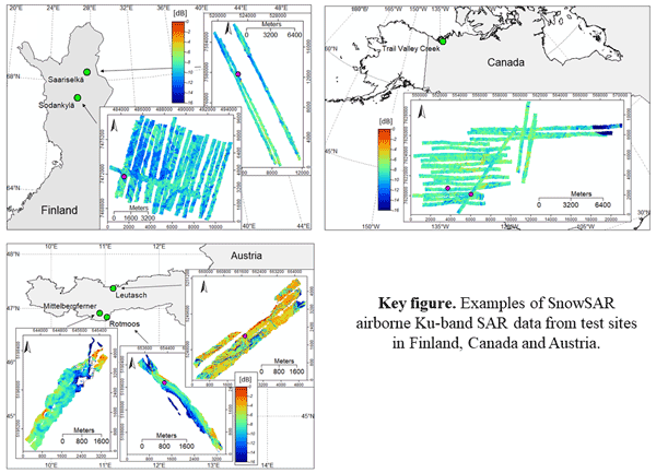
Juha Lemmetyinen, Juval Cohen, Anna Kontu, Juho Vehviläinen, Henna-Reetta Hannula, Ioanna Merkouriadi, Stefan Scheiblauer, Helmut Rott, Thomas Nagler, Elisabeth Ripper, Kelly Elder, Hans-Peter Marshall, Reinhard Fromm, Marc Adams, Chris Derksen, Joshua King, Adriano Meta, Alex Coccia, Nick Rutter, Melody Sandells, Giovanni Macelloni, Emanuele Santi, Marion Leduc-Leballeur, Richard Essery, Cecile Menard, and Michael Kern
Earth Syst. Sci. Data, 14, 3915–3945, https://doi.org/10.5194/essd-14-3915-2022, https://doi.org/10.5194/essd-14-3915-2022, 2022
Short summary
Short summary
The manuscript describes airborne, dual-polarised X and Ku band synthetic aperture radar (SAR) data collected over several campaigns over snow-covered terrain in Finland, Austria and Canada. Colocated snow and meteorological observations are also presented. The data are meant for science users interested in investigating X/Ku band radar signatures from natural environments in winter conditions.
Nikola Jovanovic, Timm Schultz, Angelika Humbert, Thomas Kleiner, and Samuel J. Cook
EGUsphere, https://doi.org/10.5194/egusphere-2026-4224, https://doi.org/10.5194/egusphere-2026-4224, 2026
This preprint is open for discussion and under review for The Cryosphere (TC).
Short summary
Short summary
The Greenland Ice Sheet (GrIS) has significantly melted in the last decades. However, melt formed on the surface can be stored in firn, a spongy layer between snow and ice. We use a model to simulate the change of the firn in a warming climate in regions of the GrIS. In southwest, thick ice layers (ice slabs) form. They limit the amount of water firn can store and their area increases with warming. In southeast, water bodies called firn aquifers form, that efficiently drain water into the ocean.
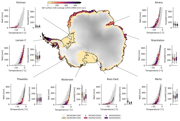
Marte Gé Hofsteenge, Willem Jan van de Berg, Christiaan van Dalum, Kristiina Verro, Maurice van Tiggelen, and Michiel van den Broeke
The Cryosphere, 20, 4747–4766, https://doi.org/10.5194/tc-20-4747-2026, https://doi.org/10.5194/tc-20-4747-2026, 2026
Short summary
Short summary
We use a regional climate model to study how surface melt on Antarctic ice shelves responds to air temperature. The relationship is strongly non-linear, mainly due to feedbacks in surface albedo, with other energy sources also contributing. Currently colder, drier, and more stable ice shelves will experience more melt at the same temperature than ice shelves in wetter climates, highlighting their vulnerability to fracturing, ice shelf instability, and contributions to global sea-level rise.
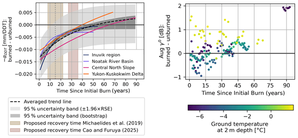
Barbara Widhalm, Annett Bartsch, and Benjamin Jones
The Cryosphere, 20, 4619–4654, https://doi.org/10.5194/tc-20-4619-2026, https://doi.org/10.5194/tc-20-4619-2026, 2026
Short summary
Short summary
This study examines the impacts of wildfires on permafrost thaw in the Arctic spanning up to ~90 years post-fire and explores the potential of using radar satellite observations to enhance our understanding of environmental change. By assessing diverse high-latitude permafrost landscapes, we show that ground deformation anomalies after fires display similar patterns across regions, while radar backscatter varies depending on predominant ground temperatures.
Sanne B. M. Veldhuijsen, Peter Kuipers Munneke, Willem Jan van de Berg, Michiel R. van den Broeke, and Luke D. Trusel
EGUsphere, https://doi.org/10.5194/egusphere-2026-3453, https://doi.org/10.5194/egusphere-2026-3453, 2026
This preprint is open for discussion and under review for The Cryosphere (TC).
Short summary
Short summary
Antarctica has floating ice shelves around its perimeter that provide stability to the ice sheet. As temperature rises, snow on the ice shelves may melt away, and ponding of meltwater may cause the ice shelves to collapse. If that happens, Antarctica may start to lose ice faster than before, resulting in accelerated sea-level rise. The tool presented in this article will be used in simulations of future climate to determine when climate change leads to collapse of the ice shelves in Antarctica.
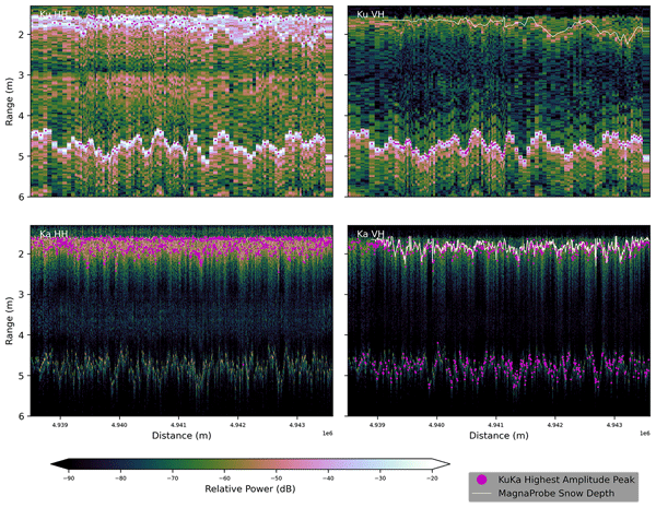
Julienne Stroeve, Rosemary Willatt, Madeleine Downie, Monojit Saha, Carmen Nab, Alicia Fallows, Clement Soriot, Robbie Mallett, Anton Komarov, Vishnu Nandan, Thomas Newman, Jennifer Lukovich, and John Yackel
The Cryosphere, 20, 4367–4399, https://doi.org/10.5194/tc-20-4367-2026, https://doi.org/10.5194/tc-20-4367-2026, 2026
Short summary
Short summary
We evaluate polarimetry for snow depth retrieval on Arctic winter transport routes. Over landfast ice and tundra, traditional dual-frequency (Ku/Ka) methods often fail. We demonstrate that cross-polarization (VH) provides a more reliable marker for snow/ice and snow/ground interfaces. For lakes, we successfully resolve air, snow, and ice interfaces to retrieve snow and ice thickness simultaneously. These results establish a baseline for future polarimetric satellite missions.
Philippe Gamet, Bimal K. Bhattacharya, Jean-Louis Roujean, Gilles Boulet, Corinne Salcedo, Albert Olioso, Kanishka Mallick, Marie Weiss, Emmanuelle Sarrazin, Emmanuelle Autret, Laure Roupioz, José Antonio Sobrino, Olivier Merlin, Ghislain Picard, Thomas H. G. Vidal, Mark Irvine, Rahul Nigam, Mehul Pandya, Simon Gascoin, Sébastien Marcq, Manoj K. Mishra, Emilie Delogu, Vincent Rivalland, Jordi Etchanchu, Jean-Louis Raynaud, Meenakshi Sarkar, Rishi K. Gangwar, Sushil K. Singh, Renaud Binet, Sara Arioli, Hervé Yésou, Isabelle Dadou, Alexei Kouraev, Julien Michel, Benoit Coudert, Samuel Mwangi, Nesrine Farhani, Ayan Das, Stéphane Saux-Picart, Thierry Tormos, Jean-François Piollé, Charles Verpoorter, Auline Rodler, Jonathan Leon Tavares, Jennifer Adams, Anand S. Sahadevan, Besavaraju Santhi Sree, Manikumar Vedantam, Dheeraj Adlakha, Laurence Buffet, Kathrin Naegeli, Itziar Barat, Jerome Demarty, Olivier Hagolle, and Philippe Maisongrande
EGUsphere, https://doi.org/10.5194/egusphere-2026-4492, https://doi.org/10.5194/egusphere-2026-4492, 2026
This preprint is open for discussion and under review for Earth Observation (EO).
Short summary
Short summary
This paper highlights how the upcoming TRISHNA satellite mission (launching 2027) will transform Earth observation by providing high-resolution (60 m) thermal infrared imagery with sub-weekly revisits. It details the mission's design and its synergies with other future missions to significantly improve the monitoring of global surface temperature and its dynamics, water stress, and ecosystem energy processes.
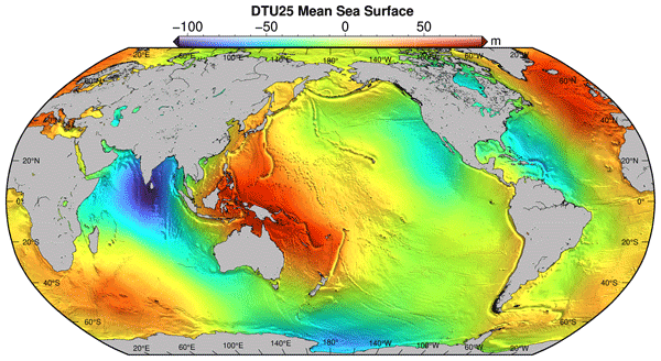
Bjarke Nilsson, Ole Baltazar Andersen, and Per Knudsen
Earth Syst. Sci. Data, 18, 5027–5051, https://doi.org/10.5194/essd-18-5027-2026, https://doi.org/10.5194/essd-18-5027-2026, 2026
Short summary
Short summary
The average height of the sea surface is important to understand if we are to accurately understand either the dynamic ocean or improve our understanding of the shape of the earth's surface. Currently we have been able to understand this to a certain degree, but with data from the new Surface Water and Ocean Topography (SWOT) satellite, we are now able to map the sea surface at a very small scale. We utilize this new data to better understand and map the shape of the global oceans.
Julien Meloche, Melody Sandells, Henning Löwe, Nick Rutter, Ghislain Picard, Richard Essery, Randall K. Scharien, Alexandre Langlois, Matthias Jaggi, Josh King, Peter Toose, Michele Scagliola, Jerome Bouffard, Alessandro Di Bella, and Christian Haas
EGUsphere, https://doi.org/10.5194/egusphere-2026-3615, https://doi.org/10.5194/egusphere-2026-3615, 2026
This preprint is open for discussion and under review for The Cryosphere (TC).
Short summary
Short summary
Sea ice thickness is essential for climate studies. Radar altimetry has provided sea ice thickness measurements, but uncertainty arises from the interaction of the signal with the snow cover. Therefore, modelling the signal interaction with the snow is necessary to improve retrieval. A radar model was used to simulate the radar signal from the snow-covered sea ice. This work paved the way to improved physical algorithms to retrieve snow depth and sea ice thickness for radar altimeter missions.
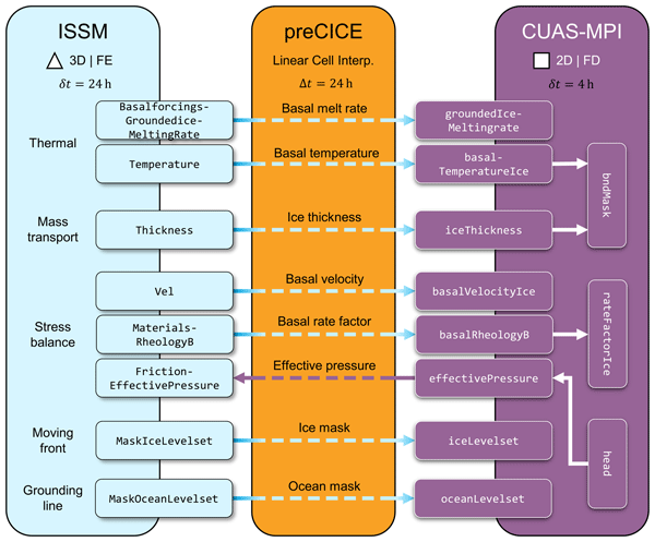
Daniel Abele, Thomas Kleiner, Yannic Fischler, Benjamin Uekermann, Gerasimos Chourdakis, Mathieu Morlighem, Achim Basermann, Christian Bischof, Hans-Joachim Bungartz, and Angelika Humbert
Geosci. Model Dev., 19, 5019–5039, https://doi.org/10.5194/gmd-19-5019-2026, https://doi.org/10.5194/gmd-19-5019-2026, 2026
Short summary
Short summary
Accurate simulations of ice-sheet evolution require a multi-physics approach that captures the interaction between glaciers and their subglacial environment. For this purpose, we have extended ice sheet and subglacial hydrology models using a coupling library. This simplifies coupled Earth systems simulations by allowing models to interact with minimal effort and computational expense. We have evaluated the solution regarding performance and choice of coupling library.
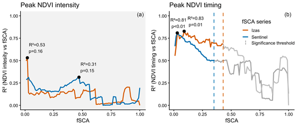
Pablo Domínguez-Aguilar, Jesús Revuelto, Simon Gascoin, and Juan I. López-Moreno
Biogeosciences, 23, 3793–3806, https://doi.org/10.5194/bg-23-3793-2026, https://doi.org/10.5194/bg-23-3793-2026, 2026
Short summary
Short summary
We studied how the timing of snowmelt shapes the growth of mountain grasslands in the western Spanish Pyrenees. Using satellite images and weather data, we found that grasslands start growing as soon as the snow disappears. However their maximum growth, occurring during summer, depends more on temperature and rainfall than on snowmelt timing. Stable patterns of productive areas suggest a strong influence of local soil and microclimate in shaping the distribution of vegetation and its growth.
Gwenael Jestin, Sara Fleury, Matthias Raynal, Marta Alves, Fanny Piras, Anaëlle Treboutte, François Boy, Inès Benabdillah, Louise Yu, and Gérald Dibarboure
EGUsphere, https://doi.org/10.5194/egusphere-2026-2569, https://doi.org/10.5194/egusphere-2026-2569, 2026
This preprint is open for discussion and under review for The Cryosphere (TC).
Short summary
Short summary
With its wide swath of 120 km, the SWOT altimeter offers unrivalled spatial and temporal coverage of the polar oceans. But frozen oceans are difficult to study because the ice cover only reveals the open ocean through cracks and polynyas. Whether studying the ice or the ocean, leads and floes must be distinguished. This classification is now available in the CNES L3 product at a resolution of 250 m. This paper outlines the methodology and improvements of the derived ice concentration maps.
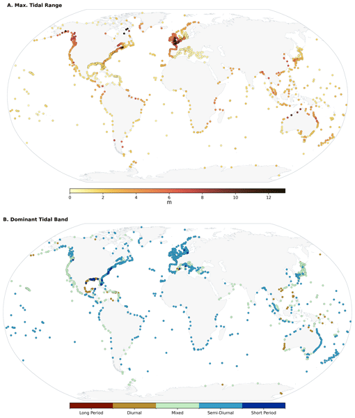
Michael G. Hart-Davis, Roman Sulzbach, Stefan A. Talke, Ivan D. Haigh, Marta Marcos, Philip Woodworth, Richard Ray, Ole B. Andersen, Florent Lyard, Ergane Fouchet, Denise Dettmering, Maik Thomas, and Florian Seitz
Ocean Sci., 22, 1681–1709, https://doi.org/10.5194/os-22-1681-2026, https://doi.org/10.5194/os-22-1681-2026, 2026
Short summary
Short summary
Ocean tides are a critical component of the global climate system, influencing a wide range of geophysical processes. Tide gauges have been a valuable source for developing the theory of ocean tides and for understanding their variability. We provide updated and new insights on tidal properties using the Global Extreme Sea Level Analysis tide gauge dataset, intended to be useful to a range of applications, from navigation and fishing communities to ocean scientists and tidal experts.
Fredrik Boberg, Xavier Fettweis, Nicolaj Hansen, Ruth Mottram, and Michiel R. van den Broeke
The Cryosphere, 20, 2947–2960, https://doi.org/10.5194/tc-20-2947-2026, https://doi.org/10.5194/tc-20-2947-2026, 2026
Short summary
Short summary
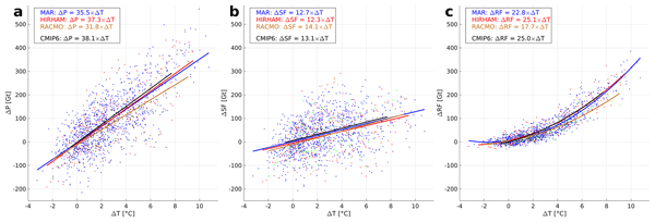
An ensemble of regional climate model simulations is used to estimate the 21st century change in precipitation on the Greenland ice sheet. For the end of the century, the change is in the range 40 to 170 Gt per year, depending on the emission scenario. Using annual values of 2 m air temperature and precipitation, we estimate an increase in precipitation of 35 Gt per year for every degree of warming.
James R. Jordan, Frank Pattyn, Daniel Abele, Torsten Albrecht, Jorge Alvarez-Solas, Jowan M. Barnes, Tijn Berends, Jorge A. Bernales, Javier Blasco, Gong Cheng, Youngmin Choi, Stephen L. Cornford, Cruz Garcia-Molina, Fabien Gillet-Chaulet, G. Hilmar Gudmundsson, Angelika Humbert, Gunter R. Leguy, William H. Lipscomb, Marisa Montoya, Daniel Moreno-Parada, Mathieu Morlighem, Tyler Pelle, Alexander Robinson, Martin Rückamp, Hélène Seroussi, Yanmei Tian, Luisa Wagner, Roderick S. W. van de Wal, Liyun Zhao, and Thomas Zwinger
EGUsphere, https://doi.org/10.5194/egusphere-2026-1962, https://doi.org/10.5194/egusphere-2026-1962, 2026
Short summary
Short summary
Ice calving is a recent inclusion in ice sheet models and there has not been a systematic test of how well it has been implemented. We show that models can accurately represent a given rate of ice calving, properties at the ice front evolve smoothly during calving, and that there are no consistent differences in ice behaviour between various approaches to representing calving in numerical ice models. This gives us confidence in their ability for use in sea level rise prediction simulations.
Samuel M. Tax, Maurice van Tiggelen, Thirza N. Feenstra, Paul C. J. P. Smeets, Srinidhi N. Gadde, Christiaan T. van Dalum, Willem Jan van de Berg, and Michiel R. van den Broeke
EGUsphere, https://doi.org/10.5194/egusphere-2026-1926, https://doi.org/10.5194/egusphere-2026-1926, 2026
Short summary
Short summary
Strong winds can lift snow into the air, which influences the energy exchange between the surface and the atmosphere. We studied this phenomenon over the Greenland Ice Sheet using observations and a climate model. We found that blowing snow traps heat near the surface like a blanket and reflects incoming sunlight like a mirror. Simulating these processes increases the net energy at the surface and improves model accuracy. Therefore, we recommend including these effects in climate models.
Steven Franke, Daniel Steinhage, Veit Helm, Tobias Binder, Uwe Nixdorf, Heinrich Miller, Angelika Humbert, Daniela Jansen, Graeme Eagles, Hannes Eisermann, Wilfried Jokat, Antonia Ruppel, Reinhard Drews, Alexandra Zuhr, Amelie Driemel, Andreas Walter, Peter Konopatzky, Robin Heß, Antonie Haas, Roland Koppe, Pascal H. Andreas, and Olaf Eisen
The Cryosphere, 20, 2485–2530, https://doi.org/10.5194/tc-20-2485-2026, https://doi.org/10.5194/tc-20-2485-2026, 2026
Short summary
Short summary
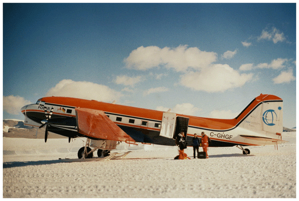
This review synthesizes 30 years of Alfred Wegener Institute’s (AWI) airborne radar research in Antarctica and Greenland, detailing six radar systems and their applications in studying ice dynamics, basal properties, and subglacial landscapes. Moreover, it introduces the public release of AWI's airborne radar datasets via the Radar Data over Polar Ice Sheets Viewer and PANGAEA, ensuring findable, accessible, interoperable, and reusable access for future polar research.
Valeria Briones, Hélène Genet, Elchin Jafarov, Brendan Rogers, Jennifer Watts, Anna-Maria Virkkala, Annett Bartsch, Benjamin Maglio, Joshua Rady, and Susan Natali
Earth Syst. Sci. Data Discuss., https://doi.org/10.5194/essd-2026-29, https://doi.org/10.5194/essd-2026-29, 2026
Preprint under review for ESSD
Short summary
Short summary
Rapid warming is reshaping Arctic landscapes as frozen ground thaws, affecting ecosystems and climate. To better understand these changes, we created a map showing the distribution of land types such as forests, shrubs, and wetlands across the Arctic and northern regions. We combined several existing maps using computer-based pattern recognition to develop a harmonized circumpolar land cover dataset that maps ecosystems across the Arctic–Boreal region at 1-km resolution for the period 2000–2023.
Ida Lundtorp Olsen, Henriette Skourup, Heidi Sallila, Stefan Hendricks, Renée Mie Fredensborg Hansen, Stefan Kern, Stephan Paul, Marion Bocquet, Sara Fleury, Dmitry Divine, and Eero Rinne
Earth Syst. Sci. Data, 18, 2469–2505, https://doi.org/10.5194/essd-18-2469-2026, https://doi.org/10.5194/essd-18-2469-2026, 2026
Short summary
Short summary
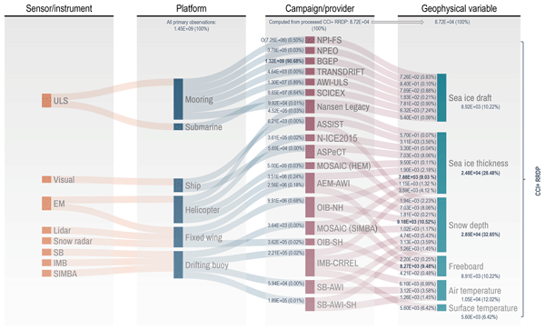
Discover the latest advancements in sea ice research with our comprehensive Climate Change Initiative (CCI) sea ice thickness (SIT) Round Robin Data Package (RRDP). This pioneering collection contains reference measurements from 1960 to 2024 from airborne sensors, buoys, visual observations and sonar and covers the polar regions from 1993 to 2024, providing crucial reference measurements for validating satellite-derived sea ice thickness.
Rasmus Tage Tonboe, Vishnu Nandan, Marcus Huntemann, Julienne Stroeve, Randall Scharien, John Yackel, Lars Kaleschke, Hoyeon Shi, and Tânia Casal
EGUsphere, https://doi.org/10.5194/egusphere-2026-1440, https://doi.org/10.5194/egusphere-2026-1440, 2026
Short summary
Short summary
Scattering and absorption from air bubbles, voids, and brine pockets significantly affect radar and microwave radiometer measurements of sea ice and light propagation through sea ice. Here, we used a high-resolution dataset, collected during the 2019–20 MOSAiC expedition, of thin ice slices of various Arctic sea ice types to estimate the autocorrelation length and density of the inclusions. The data can be used to initialize sea ice scattering models and for understanding satellite data.
Nicola Imperatore, Simon Gascoin, Matthieu Lafaysse, Marie Dumont, Adrien Mauss, Stéphane Guével, and Jean-Baptiste Hernandez
EGUsphere, https://doi.org/10.5194/egusphere-2026-1122, https://doi.org/10.5194/egusphere-2026-1122, 2026
Short summary
Short summary
Daily satellite snow cover observations are beneficial for water management in mountain regions, but it's crucial to understand their uncertainties. We evaluate the next-generation NASA constellation in mountainous terrain using higher-resolution satellite imagery as reference. We find an overall consistent performance across the platforms and combine their data to reduce cloud cover. These results support a confident transition and open new opportunities in snowpack modeling.
Simon Filhol, Clément Misset, Noélie Bontemps, Diego Cusicanqui, Emmanuel Paquet, Marie Dumont, Olivier Gagliardini, Pascal Lacroix, Simon Gascoin, Guillaume Thirel, Julien Brondex, Pascal Hagenmuller, Eric Larose, Philipp Schoeneich, Denis Roy, Emmanuel Thibert, Nicolas Eckert, Félix de Montety, Robin Mainieri, Alexandre Hauet, Frédéric Gottardi, Johan Berthet, Alexandre Baratier, Frédéric Liébault, Małgorzata Chmiel, Guillaume Piton, Guillaume Chambon, Guillaume James, Philippe Frey, Philip Deline, Laurent Astrade, Christian Vincent, Dominique Laigle, Alain Recking, Fatima Karbou, Adrien Mauss, Mylène Bonnefoy-Demongeot, Firmin Fontaine, Mickael Langlais, Etienne Berthier, and Antoine Blanc
EGUsphere, https://doi.org/10.5194/egusphere-2026-971, https://doi.org/10.5194/egusphere-2026-971, 2026
Short summary
Short summary
On June 21 2024, the village of La Bérarde, in the French Alps, was devastated by a flood destroying centuries old buildings. This study is an interdisciplinary work to decipher the causes and chronology of the event. The flood started with decadal rain falling on a thick snowpack. A lake observed on top of a glacier few days prior, had drained post event. With climate change, should we expect more similar compound events for alpine communities?
Benjamin Heurgue, Charles Amory, Christoph Kittel, Fredrik Boberg, Gaël Durand, Vincent Favier, Xavier Fettweis, Quentin Glaude, Heiko Goelzer, Nicolaj Hansen, Nicolas C. Jourdain, Ruth Mottram, Martin Olesen, Willem Jan Van de Berg, Michiel R. Van den Broeke, and René R. Wijngaard
EGUsphere, https://doi.org/10.5194/egusphere-2026-624, https://doi.org/10.5194/egusphere-2026-624, 2026
Short summary
Short summary
We studied how the Antarctic ice sheet surface mass balance may change by 2100 using three high-resolution climate models forced by the same future climate scenario. While the models agree for present-day conditions, they project very different futures, especially over floating ice shelves. These differences mainly come from how melting, refreezing, and temperature are represented. Our results show that future sea level projections strongly depend on how well models simulate today’s climate.
Thirza N. Feenstra, Willem Jan van de Berg, Gerd-Jan van Zadelhoff, David P. Donovan, Christiaan T. van Dalum, and Michiel R. van den Broeke
Atmos. Meas. Tech., 19, 1323–1344, https://doi.org/10.5194/amt-19-1323-2026, https://doi.org/10.5194/amt-19-1323-2026, 2026
Short summary
Short summary
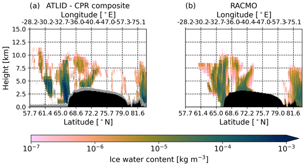
Cloud representation brings large uncertainties in polar climate modeling. We show the first evaluation of Greenland clouds in the Regional Atmospheric Climate Model (RACMO2.4) with new EarthCARE satellite data. Comparing lidar and radar observations and retrieved cloud profiles with co-located RACMO output, we find RACMO captures low ice clouds but underestimates high clouds, mid-altitude liquid clouds, and snowfall. These results highlight EarthCARE's potential to improve polar climate models.
Tesse E. A. van den Aker, Peter Kuipers Munneke, Willem Jan van de Berg, Walter W. Immerzeel, and Michiel R. van den Broeke
EGUsphere, https://doi.org/10.5194/egusphere-2026-462, https://doi.org/10.5194/egusphere-2026-462, 2026
Short summary
Short summary
The firn layer, i.e. permanent snow, regulates how an ice sheet responds to climate change. Firn models are forced with with climate data at time steps from sub-daily to annual in literature, however, implications are barely evaluated. We test the impact of different climate forcing time steps on the modeled firn layer. We conclude that the climate forcing time step (1) affects firn model output, (2) can lead to non-physical behaviour, and (3) that resolving at least a diurnal cycle is required.
Julia Wagner, Juliane Wolter, Justine Ramage, Victoria Martin, Andreas Richter, Niek Jesse Speetjens, Jorien E. Vonk, Rachele Lodi, Annett Bartsch, Michael Fritz, Hugues Lantuit, and Gustaf Hugelius
SOIL, 12, 113–132, https://doi.org/10.5194/soil-12-113-2026, https://doi.org/10.5194/soil-12-113-2026, 2026
Short summary
Short summary
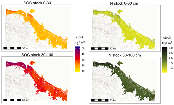
Permafrost soils store vast amounts of organic carbon, key to understanding climate change. This study uses machine learning and combines existing data with new field data to create detailed regional maps of soil carbon and nitrogen stocks for the Yukon coastal plain. The results show how soil properties vary across the landscape highlighting the importance of data selection for accurate predictions. These findings improve carbon storage estimates and may aid regional carbon budget assessments.
Ida Haven, Hans Christian Steen-Larsen, Laura J. Dietrich, Sonja Wahl, Jason E. Box, Michiel R. van den Broeke, Alun Hubbard, Stephan T. Kral, Joachim Reuder, and Maurice van Tiggelen
The Cryosphere, 20, 573–593, https://doi.org/10.5194/tc-20-573-2026, https://doi.org/10.5194/tc-20-573-2026, 2026
Short summary
Short summary
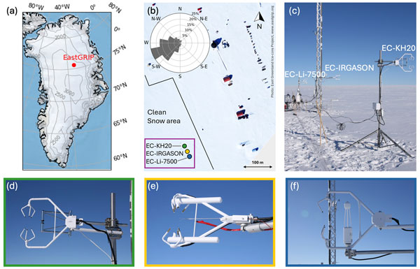
Three independent Eddy-Covariance measurement systems deployed on top of the Greenland Ice Sheet are compared. Using this dataset, we evaluate the reproducibility and quantify the differences between the systems. The fidelity of two regional climate models in capturing the seasonal variability in the latent and sensible heat flux between the snow surface and the atmosphere is assessed. We identify differences between observations and model simulations, especially during the winter period.
Hong Lin, Jinyang Du, John S. Kimball, Xiao Cheng, J. Patrick Donnelly, Jennifer D. Watts, and Annett Bartsch
Earth Syst. Sci. Data, 18, 535–549, https://doi.org/10.5194/essd-18-535-2026, https://doi.org/10.5194/essd-18-535-2026, 2026
Short summary
Short summary
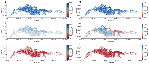
Ice cover on small water bodies is highly sensitive to climate change and influences ecosystems, water, and the carbon cycle. We produced a satellite-based ice fraction dataset for small water bodies on the Arctic Coastal Plain from 2017 to 2023. The dataset captures freeze-up and break-up timing and reveals spatial variability. It will support studies of climate–ice interactions and improve models of water and carbon processes.
Alessandro Cotronei, Ulrike Feudel, and Angelika Humbert
EGUsphere, https://doi.org/10.5194/egusphere-2025-6334, https://doi.org/10.5194/egusphere-2025-6334, 2026
Short summary
Short summary
We construct a mathematical model to describe the formation of lakes on the Greenland Ice Sheet across multiple years. The model represents the dynamics of ice, snow, and surface water, accounting for the influence of air temperature. Our results indicate that lakes can enhance ice melt by absorbing sunlight, thereby accelerating the loss of Greenland ice under realistic scenarios of temperature increase.

Horst Machguth, Andrew Tedstone, Peter Kuipers Munneke, Max Brils, Brice Noël, Nicole Clerx, Nicolas Jullien, Xavier Fettweis, and Michiel van den Broeke
The Cryosphere, 20, 427–452, https://doi.org/10.5194/tc-20-427-2026, https://doi.org/10.5194/tc-20-427-2026, 2026
Short summary
Short summary
Due to increasing air temperatures, surface melt expands to higher elevations on the Greenland ice sheet. This is visible on satellite imagery in the form of rivers of meltwater running across the surface of the ice sheet. We compare model results of meltwater at high elevations on the ice sheet to satellite observations. We find that each of the models shows strengths and weaknesses. A detailed look into the model results reveals potential reasons for the differences between models.
Esteban Alonso-González, Adrian Harpold, Jessica D. Lundquist, Cara Piske, Laura Sourp, Kristoffer Aalstad, and Simon Gascoin
The Cryosphere, 20, 209–225, https://doi.org/10.5194/tc-20-209-2026, https://doi.org/10.5194/tc-20-209-2026, 2026
Short summary
Short summary
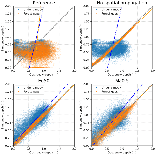
Simulating the snowpack is challenging, as there are several sources of uncertainty due to e.g. the meteorological forcing. Using data assimilation techniques, it is possible to improve the simulations by fusing models and snow observations. However in forests, observations are difficult to obtain, because they cannot be retrieved through the canopy. Here, we explore the possibility of propagating the information obtained in forest clearings to areas covered by the canopy.
Valentin Ludwig, Caroline Ribere, Sara Fleury, Christian Haas, Michel Tsamados, Mahmoud El Hajj, Jerome Bouffard, Michele Scagliola, Marion Bocquet, Eric de Boisseson, Vincent Boulenger, Guillaume Boutin, Laurence Connor, Léo Edel, Stefan Hendricks, Ferran Hernández Macià, Marcus Huntemann, Lars Kaleschke, Frank Kauker, Jack Landy, Tom Megain, Alek Petty, Till Soya Rasmussen, Mads Hvid Ribergaard, Robert Ricker, Axel Schweiger, Hoyeon Shi, Xiangshan Tian-Kunze, Donghui Yi, and Alessandro Di Bella
EGUsphere, https://doi.org/10.5194/egusphere-2025-6201, https://doi.org/10.5194/egusphere-2025-6201, 2026
Short summary
Short summary
Our paper compares Arctic sea-ice thickness datasets from models, reanalyses, satellite-only, and multi-product sources. We validate them against Beaufort Sea reference data, compare large-scale products, and analyse time series. Cross-product biases range from 0.2–0.4 m, RMSDs from 0.4–0.9 m, and correlations from 0.5–0.8. We find no 2010–2023 trend, but 1995–2023 thinning of ~ 0.5 m in November and ~ 0.3 m in March.
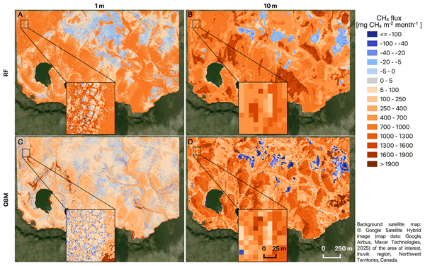
Kseniia Ivanova, Anna-Maria Virkkala, Victor Brovkin, Tobias Stacke, Barbara Widhalm, Annett Bartsch, Carolina Voigt, Oliver Sonnentag, and Mathias Göckede
Biogeosciences, 23, 233–262, https://doi.org/10.5194/bg-23-233-2026, https://doi.org/10.5194/bg-23-233-2026, 2026
Short summary
Short summary
We measured over 13,000 methane fluxes at a site in the Canadian Arctic and linked them with drone and free satellite images. We tested four machine-learning methods and two map scales. Metre-scale maps captured small wet and dry features that strongly affect methane release, while coarser maps blurred them. Different models shifted the monthly methane estimate. This helps choose the right data and tools to map methane, design monitoring networks, and check climate models.
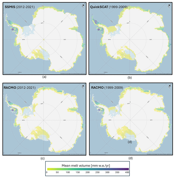
Valeria Di Biase, Peter Kuipers Munneke, Bert Wouters, Michiel R. van den Broeke, and Maurice van Tiggelen
The Cryosphere, 20, 87–96, https://doi.org/10.5194/tc-20-87-2026, https://doi.org/10.5194/tc-20-87-2026, 2026
Short summary
Short summary
We produce annual maps of Antarctic surface melt volumes from 2012 to 2021 using satellite microwave data. We detect melting days from thresholds on the satellite signal and then use actual melt measurements from weather stations to convert those signals into water‑equivalent volumes. Our maps capture known melt hotspots and show slightly lower totals than climate models. This dataset supports climate and ice‑shelf studies.

Heiko Goelzer, Constantijn J. Berends, Fredrik Boberg, Gael Durand, Tamsin L. Edwards, Xavier Fettweis, Fabien Gillet-Chaulet, Quentin Glaude, Philippe Huybrechts, Sébastien Le clec'h, Ruth Mottram, Brice Noël, Martin Olesen, Charlotte Rahlves, Jeremy Rohmer, Michiel van den Broeke, and Roderik S. W. van de Wal
The Cryosphere, 19, 6887–6906, https://doi.org/10.5194/tc-19-6887-2025, https://doi.org/10.5194/tc-19-6887-2025, 2025
Short summary
Short summary
We present an ensemble of ice sheet model projections for the Greenland ice sheet. The focus is on providing projections that improve our understanding of the range future sea-level rise and the inherent uncertainties over the next 100 to 300 years. Compared to earlier work we more fully account for some of the uncertainties in sea-level projections. We include a wider range of climate model output, more climate change scenarios and we extend projections schematically up to year 2300.
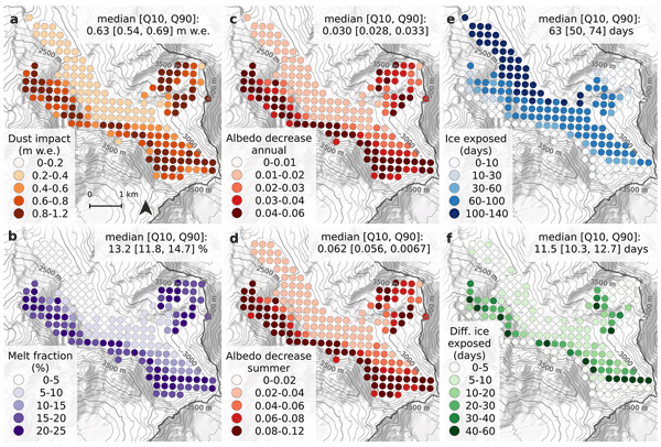
Léon Roussel, Marie Dumont, Marion Réveillet, Delphine Six, Marin Kneib, Pierre Nabat, Kévin Fourteau, Diego Monteiro, Simon Gascoin, Emmanuel Thibert, Antoine Rabatel, Jean-Emmanuel Sicart, Mylène Bonnefoy, Luc Piard, Olivier Laarman, Bruno Jourdain, Mathieu Fructus, Matthieu Vernay, and Matthieu Lafaysse
The Cryosphere, 19, 5201–5230, https://doi.org/10.5194/tc-19-5201-2025, https://doi.org/10.5194/tc-19-5201-2025, 2025
Short summary
Short summary
Saharan dust deposits frequently turn alpine glaciers orange. Mineral dust reduces snow albedo and increases snow and glaciers melt rate. Using physical modeling, we quantified the impact of dust on the Argentière Glacier over the period 2019–2022. We found that the contribution of mineral dust to the melt represents between 8 % and 16 % of Argentière Glacier summer melt. At specific locations, the impact of dust over one year can rise to an equivalent of 1.2 m of melted ice.
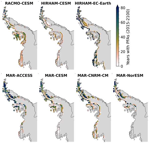
Sanne B. M. Veldhuijsen, Willem Jan van de Berg, Peter Kuipers Munneke, Nicolaj Hansen, Fredrik Boberg, Christoph Kittel, Charles Amory, and Michiel R. van den Broeke
The Cryosphere, 19, 5157–5173, https://doi.org/10.5194/tc-19-5157-2025, https://doi.org/10.5194/tc-19-5157-2025, 2025
Short summary
Short summary
Perennial firn aquifers (PFAs), year-round bodies of liquid water within firns, can potentially impact ice-shelf and ice-sheet stability. We developed a fast XGBoost firn emulator to predict the 21st-century distribution of PFAs in Antarctica for 12 climatic forcing datasets. Our findings suggest that, in low-emission scenarios, PFAs remain confined to the Antarctic Peninsula. However, in a high-emission scenario, PFAs are projected to expand to a region in West Antarctica and East Antarctica.
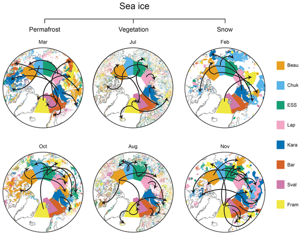
Annett Bartsch, Rodrigue Tanguy, Helena Bergstedt, Clemens von Baeckmann, Hans Tømmervik, Marc Macias-Fauria, Juha Lemmetyinen, Kimmo Rautiainen, Chiara Gruber, and Bruce C. Forbes
The Cryosphere, 19, 4929–4967, https://doi.org/10.5194/tc-19-4929-2025, https://doi.org/10.5194/tc-19-4929-2025, 2025
Short summary
Short summary
We identified similarities between sea ice dynamics and conditions on land across the Arctic, above 60° N, for 2000–2019. Significant correlations were more common for snow water equivalent and permafrost ground temperature than for the vegetation parameters. Changes across all the different parameters could specifically be determined for eastern Siberia. The results provide a baseline for future studies on common drivers of essential climate variables and causative effects across the Arctic.
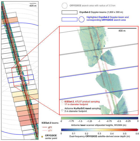
Renée Mie Fredensborg Hansen, Henriette Skourup, Eero Rinne, Arttu Jutila, Isobel R. Lawrence, Andrew Shepherd, Knut Vilhelm Høyland, Jilu Li, Fernando Rodriguez-Morales, Sebastian Bjerregaaard Simonsen, Jeremy Wilkinson, Gaelle Veyssiere, Donghui Yi, René Forsberg, and Taniâ Gil Duarte Casal
The Cryosphere, 19, 4193–4209, https://doi.org/10.5194/tc-19-4193-2025, https://doi.org/10.5194/tc-19-4193-2025, 2025
Short summary
Short summary
An airborne campaign collected unprecedented coincident multi-frequency radar and lidar data over sea ice along a CryoSat-2 and ICESat-2 (CRYO2ICE) orbit in the Weddell Sea, useful for evaluating microwave snow penetration. Ka-band and Ku-band had limited penetration with significant contributions from the air–snow interface, contradicting traditional assumptions with discrepancies between commonly used C/S-band "snow-radar" methodologies, all challenging comparisons of airborne and spaceborne estimates.
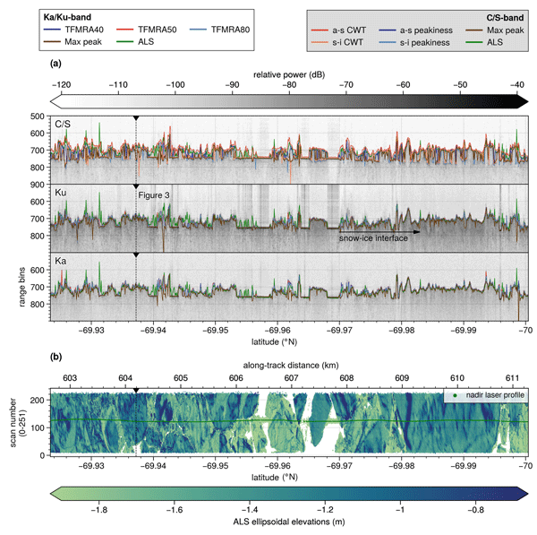
Renée Mie Fredensborg Hansen, Henriette Skourup, Eero Rinne, Arttu Jutila, Isobel R. Lawrence, Andrew Shepherd, Knut Vilhelm Høyland, Jilu Li, Fernando Rodriguez-Morales, Sebastian Bjerregaaard Simonsen, Jeremy Wilkinson, Gaelle Veyssiere, Donghui Yi, René Forsberg, and Taniâ Gil Duarte Casal
The Cryosphere, 19, 4167–4192, https://doi.org/10.5194/tc-19-4167-2025, https://doi.org/10.5194/tc-19-4167-2025, 2025
Short summary
Short summary
An airborne campaign collected unprecedented coincident multi-frequency radar and lidar data over sea ice along a CryoSat-2 and ICESat-2 (CRYO2ICE) orbit in the Weddell Sea, useful for evaluating microwave snow penetration. Ka-band and Ku-band had limited penetration with significant contributions from the air–snow interface, contradicting traditional assumptions with discrepancies between commonly used C/S-band "snow-radar" methodologies, all challenging comparisons of airborne and spaceborne estimates.
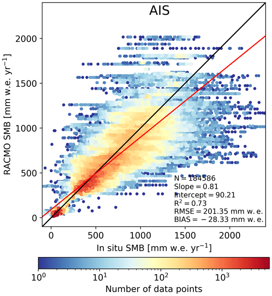
Christiaan T. van Dalum, Willem Jan van de Berg, Michiel R. van den Broeke, and Maurice van Tiggelen
The Cryosphere, 19, 4061–4090, https://doi.org/10.5194/tc-19-4061-2025, https://doi.org/10.5194/tc-19-4061-2025, 2025
Short summary
Short summary
In this study, we present a new surface mass balance (SMB) and near-surface climate product for Antarctica with the regional climate model RACMO2.4p1. We assess the impact of major model updates on the climate of Antarctica. Locally, the SMB has changed substantially but also agrees well with observations. In addition, we show that the SMB components, surface energy budget, albedo, pressure, temperature, and wind speed compare well with in situ and remote sensing observations.
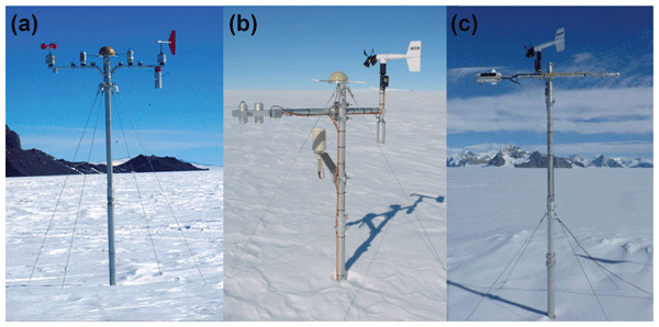
Maurice van Tiggelen, Paul C. J. P. Smeets, Carleen H. Reijmer, Peter Kuipers Munneke, and Michiel R. van den Broeke
Earth Syst. Sci. Data, 17, 4933–4955, https://doi.org/10.5194/essd-17-4933-2025, https://doi.org/10.5194/essd-17-4933-2025, 2025
Short summary
Short summary
This paper describes the measurements from the 19 IMAU (Institute for Marine and Atmospheric research Utrecht) automatic weather stations that operated on the Antarctic ice sheet from 1995 through 2022. These stations also measured the net surface radiation and surface height change, allowing for the quantification of the surface energy and mass balance at hourly resolution. These data are invaluable for the evaluation of atmospheric models and for the detection of climatological changes.
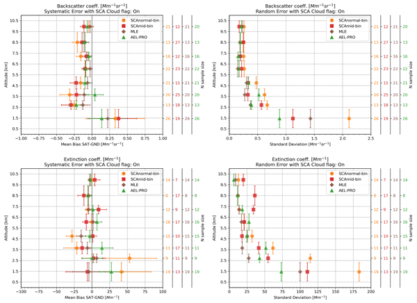
Peristera Paschou, Nikolaos Siomos, Eleni Marinou, Antonis Gkikas, Samira M. Idrissa, Daniel T. Quaye, Désiré D. Fiogbe Attannon, Kalliopi Artemis Voudouri, Charikleia Meleti, David P. Donovan, George Georgoussis, Tommaso Parrinello, Thorsten Fehr, Jonas von Bismarck, and Vassilis Amiridis
Atmos. Meas. Tech., 18, 4731–4754, https://doi.org/10.5194/amt-18-4731-2025, https://doi.org/10.5194/amt-18-4731-2025, 2025
Short summary
Short summary
This study presents the results from a validation study on the Level 2A products (aerosol optical properties) of the ESA's (European Space Agency) Aeolus mission. Measurements from the eVe lidar, a combined linear/circular polarization and Raman lidar and ESA's ground reference system, that have been collected during the Joint Aeolus Tropical Atlantic Campaign are compared with collocated Aeolus Level 2A profiles obtained from the latest version (Baseline 16) of the Aeolus algorithms.
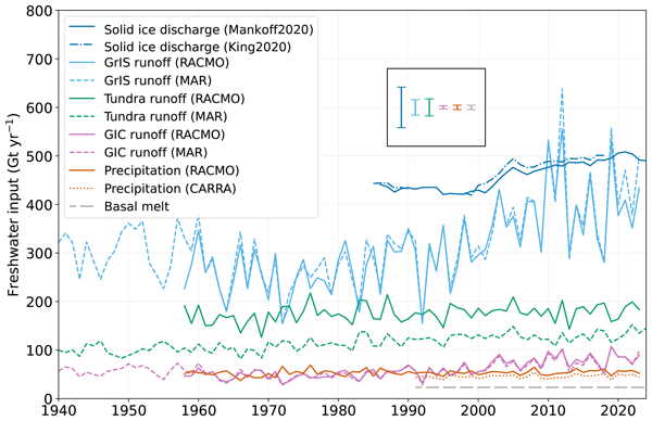
Anneke L. Vries, Willem Jan van de Berg, Brice Noël, Lorenz Meire, and Michiel R. van den Broeke
The Cryosphere, 19, 3897–3914, https://doi.org/10.5194/tc-19-3897-2025, https://doi.org/10.5194/tc-19-3897-2025, 2025
Short summary
Short summary
Freshwater flows into Greenland's fjords from various sources. Solid ice discharge (e.g. calving icebergs) dominates freshwater input in the southeast and northwest. In contrast, in the southwest, runoff from the ice sheet and tundra are the most significant. Seasonal data revealed that fjord precipitation and tundra runoff contribute up to 11 % and 35 % of the monthly freshwater input, respectively. Our results provide valuable input for ocean models and for researchers studying fjord ecosystems.
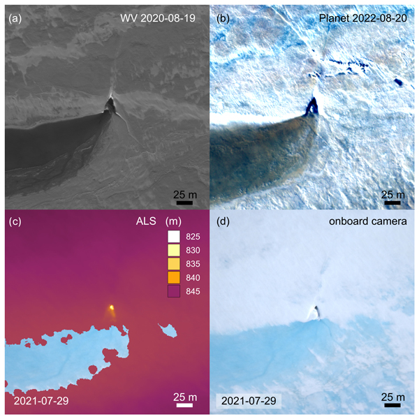
Angelika Humbert, Veit Helm, Ole Zeising, Niklas Neckel, Matthias H. Braun, Shfaqat Abbas Khan, Martin Rückamp, Holger Steeb, Julia Sohn, Matthias Bohnen, and Ralf Müller
The Cryosphere, 19, 3009–3032, https://doi.org/10.5194/tc-19-3009-2025, https://doi.org/10.5194/tc-19-3009-2025, 2025
Short summary
Short summary
We study the evolution of a massive lake on the Greenland Ice Sheet using satellite and airborne data and some modelling. The lake is emptying rapidly. Water flows to the glacier's base through cracks and triangular-shaped moulins that remain visible over the years. Some of them become reactivated. We find features inside the glacier that stem from drainage events with a width of even 1 km. These features are persistent over the years, although they are changing in shape.
Katrina Lutz, Ilaria Tabone, Angelika Humbert, and Matthias Braun
The Cryosphere, 19, 2601–2614, https://doi.org/10.5194/tc-19-2601-2025, https://doi.org/10.5194/tc-19-2601-2025, 2025
Short summary
Short summary
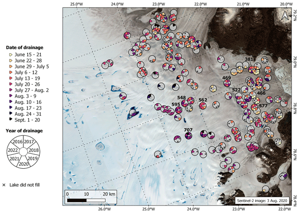
Supraglacial lakes develop from meltwater collecting on the surface of glaciers. These lakes can drain rapidly, discharging meltwater to the glacier bed. In this study, we assess the spatial and temporal distribution of rapid drainages in Northeast Greenland using optical satellite images. After comparing rapid drainage occurrence with several environmental and geophysical parameters, little indication of the influencing conditions for a rapid drainage was found.
Zacharie Barrou Dumont, Simon Gascoin, Jordi Inglada, Andreas Dietz, Jonas Köhler, Matthieu Lafaysse, Diego Monteiro, Carlo Carmagnola, Arthur Bayle, Jean-Pierre Dedieu, Olivier Hagolle, and Philippe Choler
The Cryosphere, 19, 2407–2429, https://doi.org/10.5194/tc-19-2407-2025, https://doi.org/10.5194/tc-19-2407-2025, 2025
Short summary
Short summary
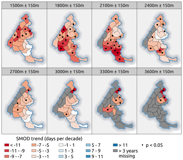
We generated annual maps of snow melt-out days at 20 m resolution over a period of 38 years from 10 different satellites. This study fills a knowledge gap regarding the evolution of mountain snow in Europe by covering a much longer period and characterizing trends at much higher resolutions than previous studies. We found a trend for earlier melt-out with average reductions of 5.51 d per decade over the French Alps and 4.04 d per decade over the Pyrenees for the period 1986–2023.
Shfaqat A. Khan, Helene Seroussi, Mathieu Morlighem, William Colgan, Veit Helm, Gong Cheng, Danjal Berg, Valentina R. Barletta, Nicolaj K. Larsen, William Kochtitzky, Michiel van den Broeke, Kurt H. Kjær, Andy Aschwanden, Brice Noël, Jason E. Box, Joseph A. MacGregor, Robert S. Fausto, Kenneth D. Mankoff, Ian M. Howat, Kuba Oniszk, Dominik Fahrner, Anja Løkkegaard, Eigil Y. H. Lippert, Alicia Bråtner, and Javed Hassan
Earth Syst. Sci. Data, 17, 3047–3071, https://doi.org/10.5194/essd-17-3047-2025, https://doi.org/10.5194/essd-17-3047-2025, 2025
Short summary
Short summary
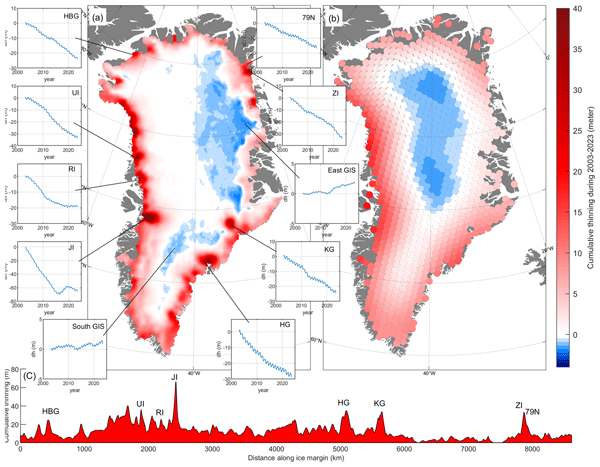
The surface elevation of the Greenland Ice Sheet is changing due to surface mass balance processes and ice dynamics, each exhibiting distinct spatiotemporal patterns. Here, we employ satellite and airborne altimetry data with fine spatial (1 km) and temporal (monthly) resolutions to document this spatiotemporal evolution from 2003 to 2023. This dataset of fine-resolution altimetry data in both space and time will support studies of ice mass loss and be useful for GIS ice sheet modeling.

Lea-Sophie Höyns, Thomas Kleiner, Andreas Rademacher, Martin Rückamp, Michael Wolovick, and Angelika Humbert
The Cryosphere, 19, 2133–2158, https://doi.org/10.5194/tc-19-2133-2025, https://doi.org/10.5194/tc-19-2133-2025, 2025
Short summary
Short summary
The sliding of glaciers over bedrock is influenced by water pressure in the underlying hydrological system and the roughness of the land underneath the glacier. We estimate this roughness through a modeling approach that optimizes this unknown parameter. Additionally, we simulate water pressure, enhancing the reliability of the computed drag at the ice sheet base. The resulting data are provided to other modelers and scientists conducting geophysical field observations.
Qing Ying, Benjamin Poulter, Jennifer D. Watts, Kyle A. Arndt, Anna-Maria Virkkala, Lori Bruhwiler, Youmi Oh, Brendan M. Rogers, Susan M. Natali, Hilary Sullivan, Amanda Armstrong, Eric J. Ward, Luke D. Schiferl, Clayton D. Elder, Olli Peltola, Annett Bartsch, Ankur R. Desai, Eugénie Euskirchen, Mathias Göckede, Bernhard Lehner, Mats B. Nilsson, Matthias Peichl, Oliver Sonnentag, Eeva-Stiina Tuittila, Torsten Sachs, Aram Kalhori, Masahito Ueyama, and Zhen Zhang
Earth Syst. Sci. Data, 17, 2507–2534, https://doi.org/10.5194/essd-17-2507-2025, https://doi.org/10.5194/essd-17-2507-2025, 2025
Short summary
Short summary
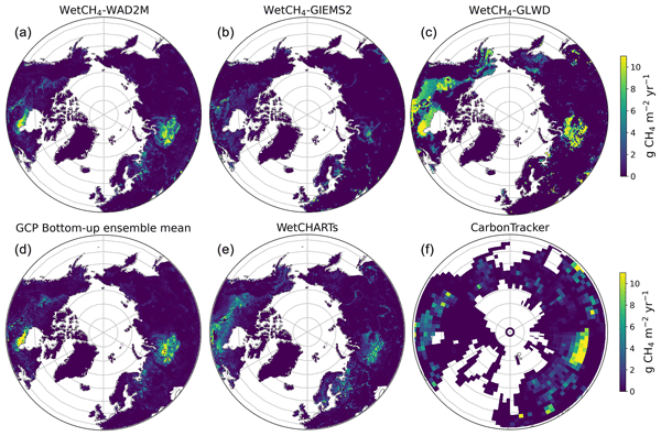
We present daily methane (CH4) fluxes of northern wetlands at 10 km resolution during 2016–2022 (WetCH4) derived from a novel machine learning framework. We estimated an average annual CH4 emission of 22.8 ± 2.4 Tg CH4 yr−1 (15.7–51.6 Tg CH4 yr−1). Emissions were intensified in 2016, 2020, and 2022, with the largest interannual variation coming from Western Siberia. Continued, all-season tower observations and improved soil moisture products are needed for future improvement of CH4 upscaling.
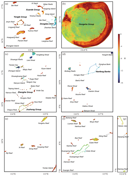
Yihao Wu, Hongkai Shi, Dongzhen Jia, Ole Baltazar Andersen, Xiufeng He, Zhicai Luo, Yu Li, Shiyuan Chen, Xiaohuan Si, Sisu Diao, Yihuang Shi, and Yanglin Chen
Earth Syst. Sci. Data, 17, 2463–2488, https://doi.org/10.5194/essd-17-2463-2025, https://doi.org/10.5194/essd-17-2463-2025, 2025
Short summary
Short summary
We developed a high-quality and cost-effective shallow-water depth model for >120 islands in the South China Sea, using ICESat-2 and Sentinel-2 satellite data. This model maps water depths with an accuracy of ~1 m. Our findings highlight the limitations of existing global bathymetry models in shallow regions. Our model exhibited superior performance in capturing fine-scale bathymetric features with unprecedented spatial resolution, providing essential data for marine applications.
Valeria Briones, Hélène Genet, Elchin E. Jafarov, Brendan M. Rogers, Jennifer D. Watts, Anna-Maria Virkkala, Annett Bartsch, Benjamin C. Maglio, Joshua Rady, and Susan M. Natali
Earth Syst. Sci. Data Discuss., https://doi.org/10.5194/essd-2025-226, https://doi.org/10.5194/essd-2025-226, 2025
Manuscript not accepted for further review
Short summary
Short summary
Arctic warming is causing permafrost to thaw, affecting ecosystems and climate. Since land cover, especially vegetation, shapes how permafrost responds, accurate maps are crucial. Using machine learning, we combined existing global and regional datasets to create a hybrid detailed 1-km map of Arctic-Boreal land cover, improving the representation of forests, shrubs, and wetlands across the circumpolar.
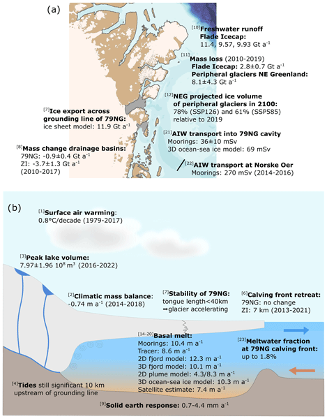
Torsten Kanzow, Angelika Humbert, Thomas Mölg, Mirko Scheinert, Matthias Braun, Hans Burchard, Francesca Doglioni, Philipp Hochreuther, Martin Horwath, Oliver Huhn, Maria Kappelsberger, Jürgen Kusche, Erik Loebel, Katrina Lutz, Ben Marzeion, Rebecca McPherson, Mahdi Mohammadi-Aragh, Marco Möller, Carolyne Pickler, Markus Reinert, Monika Rhein, Martin Rückamp, Janin Schaffer, Muhammad Shafeeque, Sophie Stolzenberger, Ralph Timmermann, Jenny Turton, Claudia Wekerle, and Ole Zeising
The Cryosphere, 19, 1789–1824, https://doi.org/10.5194/tc-19-1789-2025, https://doi.org/10.5194/tc-19-1789-2025, 2025
Short summary
Short summary
The Greenland Ice Sheet represents the second-largest contributor to global sea-level rise. We quantify atmosphere, ice and ocean processes related to the mass balance of glaciers in northeast Greenland, focusing on Greenland’s largest floating ice tongue, the 79° N Glacier. We find that together, the different in situ and remote sensing observations and model simulations reveal a consistent picture of a coupled atmosphere–ice sheet–ocean system that has entered a phase of major change.
Amy E. Swiggs, Isobel R. Lawrence, and Andrew Shepherd
EGUsphere, https://doi.org/10.5194/egusphere-2025-693, https://doi.org/10.5194/egusphere-2025-693, 2025
Preprint withdrawn
Short summary
Short summary
We produce a new sea ice concentration product in the Canadian Arctic. This region is vital for shipping, sea ice dependent species, and the movement of sea ice and freshwater. We find that the new dataset agrees well with existing sensors. As it is sensitive to leads, it can detect fine-scale sea ice features, and generally resolves a lower sea ice concentration for this reason. This different approach is important for monitoring sea ice dynamics in a changing climate.
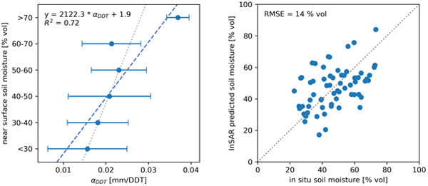
Barbara Widhalm, Annett Bartsch, Tazio Strozzi, Nina Jones, Artem Khomutov, Elena Babkina, Marina Leibman, Rustam Khairullin, Mathias Göckede, Helena Bergstedt, Clemens von Baeckmann, and Xaver Muri
The Cryosphere, 19, 1103–1133, https://doi.org/10.5194/tc-19-1103-2025, https://doi.org/10.5194/tc-19-1103-2025, 2025
Short summary
Short summary
Mapping soil moisture in Arctic permafrost regions is crucial for various activities, but it is challenging with typical satellite methods due to the landscape's diversity. Seasonal freezing and thawing cause the ground to periodically rise and subside. Our research demonstrates that this seasonal ground settlement, measured with Sentinel-1 satellite data, is larger in areas with wetter soils. This method helps to monitor permafrost degradation.
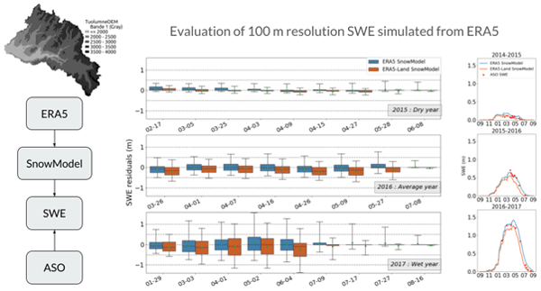
Laura Sourp, Simon Gascoin, Lionel Jarlan, Vanessa Pedinotti, Kat J. Bormann, and Mohamed Wassim Baba
Hydrol. Earth Syst. Sci., 29, 597–611, https://doi.org/10.5194/hess-29-597-2025, https://doi.org/10.5194/hess-29-597-2025, 2025
Short summary
Short summary
Accurate knowledge of the spatial distribution of snow masses across landscapes is important for water management in mountain catchments. We present a new tool for estimating snow water resources without ground measurements. We evaluate the output of this tool using accurate airborne measurements in the Sierra Nevada and find that it provides realistic estimates of snow mass and snow depth at the catchment scale.
Annett Bartsch, Xaver Muri, Markus Hetzenecker, Kimmo Rautiainen, Helena Bergstedt, Jan Wuite, Thomas Nagler, and Dmitry Nicolsky
The Cryosphere, 19, 459–483, https://doi.org/10.5194/tc-19-459-2025, https://doi.org/10.5194/tc-19-459-2025, 2025
Short summary
Short summary
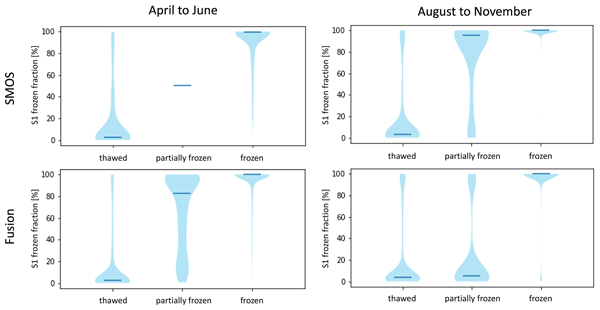
We developed a robust freeze–thaw detection approach, applying a constant threshold to Copernicus Sentinel-1 data that is suitable for tundra regions. All global, coarser-resolution products, tested with the resulting benchmarking dataset, are of value for freeze–thaw retrieval, although differences were found depending on the seasons, particularly during the spring and autumn transition.
Monojit Saha, Julienne Stroeve, Dustin Isleifson, John Yackel, Vishnu Nandan, Jack Christopher Landy, and Hoi Ming Lam
The Cryosphere, 19, 325–346, https://doi.org/10.5194/tc-19-325-2025, https://doi.org/10.5194/tc-19-325-2025, 2025
Short summary
Short summary
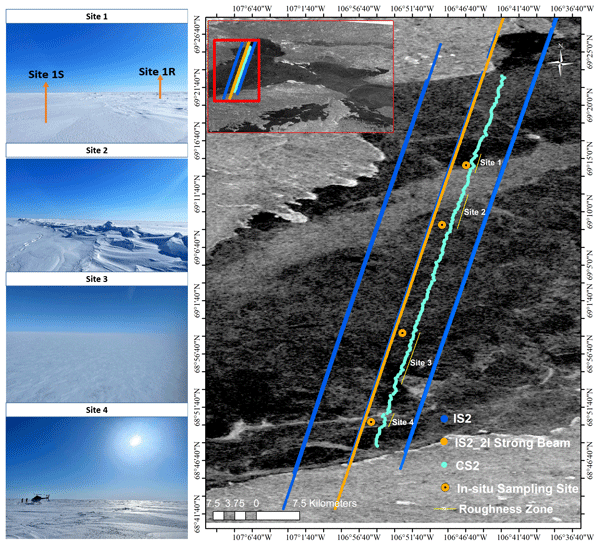
Snow on sea ice is vital for near-shore sea ice geophysical and biological processes. Past studies have measured snow depths using the satellite altimeters Cryosat-2 and ICESat-2 (Cryo2Ice), but estimating sea surface height from leadless landfast sea ice remains challenging. Snow depths from Cryo2Ice are compared to in situ data after adjusting for tides. Realistic snow depths are retrieved, but differences in roughness, satellite footprints, and snow geophysical properties are identified.
Thibault Xavier, Laurent Orgogozo, Anatoly S. Prokushkin, Esteban Alonso-González, Simon Gascoin, and Oleg S. Pokrovsky
The Cryosphere, 18, 5865–5885, https://doi.org/10.5194/tc-18-5865-2024, https://doi.org/10.5194/tc-18-5865-2024, 2024
Short summary
Short summary
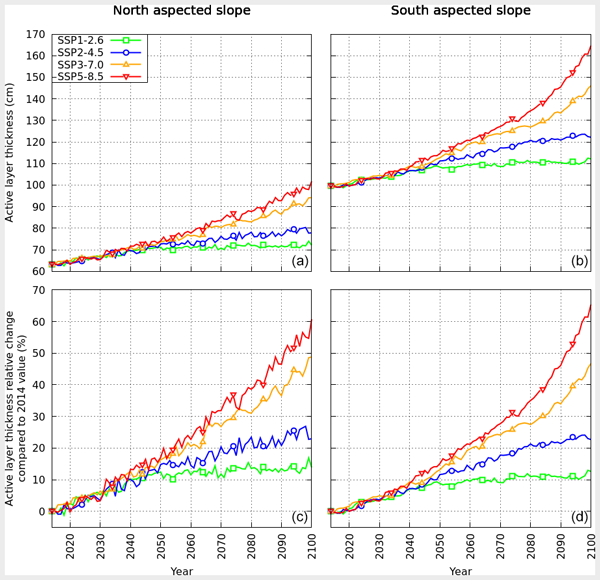
Permafrost (permanently frozen soil at depth) is thawing as a result of climate change. However, estimating its future degradation is particularly challenging due to the complex multi-physical processes involved. In this work, we designed and ran numerical simulations for months on a supercomputer to quantify the impact of climate change in a forested valley of central Siberia. There, climate change could increase the thickness of the seasonally thawed soil layer in summer by up to 65 % by 2100.
Katrina Lutz, Lily Bever, Christian Sommer, Thorsten Seehaus, Angelika Humbert, Mirko Scheinert, and Matthias Braun
The Cryosphere, 18, 5431–5449, https://doi.org/10.5194/tc-18-5431-2024, https://doi.org/10.5194/tc-18-5431-2024, 2024
Short summary
Short summary
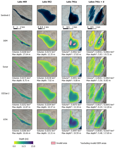
The estimation of the amount of water found within supraglacial lakes is important for understanding how much water is lost from glaciers each year. Here, we develop two new methods for estimating supraglacial lake volume that can be easily applied on a large scale. Furthermore, we compare these methods to two previously developed methods in order to determine when it is best to use each method. Finally, three of these methods are applied to peak melt dates over an area in Northeast Greenland.
Clemens von Baeckmann, Annett Bartsch, Helena Bergstedt, Aleksandra Efimova, Barbara Widhalm, Dorothee Ehrich, Timo Kumpula, Alexander Sokolov, and Svetlana Abdulmanova
The Cryosphere, 18, 4703–4722, https://doi.org/10.5194/tc-18-4703-2024, https://doi.org/10.5194/tc-18-4703-2024, 2024
Short summary
Short summary
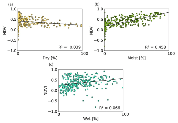
Lakes are common features in Arctic permafrost areas. Land cover change following their drainage needs to be monitored since it has implications for ecology and the carbon cycle. Satellite data are key in this context. We compared a common vegetation index approach with a novel land-cover-monitoring scheme. Land cover information provides specific information on wetland features. We also showed that the bioclimatic gradients play a significant role after drainage within the first 10 years.
Cecile B. Menard, Sirpa Rasmus, Ioanna Merkouriadi, Gianpaolo Balsamo, Annett Bartsch, Chris Derksen, Florent Domine, Marie Dumont, Dorothee Ehrich, Richard Essery, Bruce C. Forbes, Gerhard Krinner, David Lawrence, Glen Liston, Heidrun Matthes, Nick Rutter, Melody Sandells, Martin Schneebeli, and Sari Stark
The Cryosphere, 18, 4671–4686, https://doi.org/10.5194/tc-18-4671-2024, https://doi.org/10.5194/tc-18-4671-2024, 2024
Short summary
Short summary
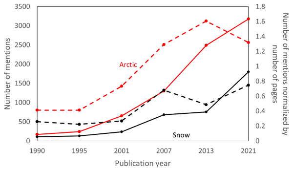
Computer models, like those used in climate change studies, are written by modellers who have to decide how best to construct the models in order to satisfy the purpose they serve. Using snow modelling as an example, we examine the process behind the decisions to understand what motivates or limits modellers in their decision-making. We find that the context in which research is undertaken is often more crucial than scientific limitations. We argue for more transparency in our research practice.
Maria T. Kappelsberger, Martin Horwath, Eric Buchta, Matthias O. Willen, Ludwig Schröder, Sanne B. M. Veldhuijsen, Peter Kuipers Munneke, and Michiel R. van den Broeke
The Cryosphere, 18, 4355–4378, https://doi.org/10.5194/tc-18-4355-2024, https://doi.org/10.5194/tc-18-4355-2024, 2024
Short summary
Short summary
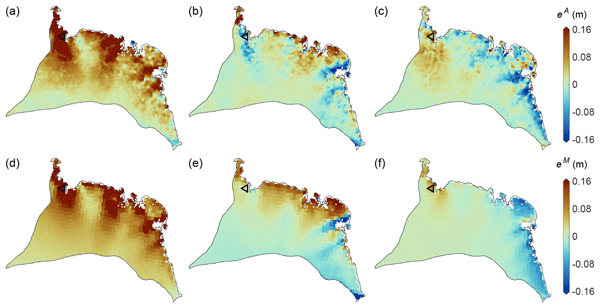
The interannual variations in the height of the Antarctic Ice Sheet (AIS) are mainly due to natural variations in snowfall. Precise knowledge of these variations is important for the detection of any long-term climatic trends in AIS surface elevation. We present a new product that spatially resolves these height variations over the period 1992–2017. The product combines the strengths of atmospheric modeling results and satellite altimetry measurements.
David L. McCann, Adrien C. H. Martin, Karlus A. C. de Macedo, Ruben Carrasco Alvarez, Jochen Horstmann, Louis Marié, José Márquez-Martínez, Marcos Portabella, Adriano Meta, Christine Gommenginger, Petronilo Martin-Iglesias, and Tania Casal
Ocean Sci., 20, 1109–1122, https://doi.org/10.5194/os-20-1109-2024, https://doi.org/10.5194/os-20-1109-2024, 2024
Short summary
Short summary
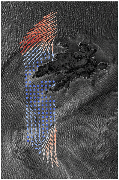
This paper presents the results of the first scientific campaign of a new method to remotely sense the small-scale, fast-evolving dynamics that are vital to our understanding of coastal and shelf sea processes. This work represents the first demonstration of the simultaneous measurement of current and wind vectors from this novel method. Comparisons with other current measuring systems and models around the dynamic area of the Iroise Sea are presented and show excellent agreement.
Christiaan T. van Dalum, Willem Jan van de Berg, Srinidhi N. Gadde, Maurice van Tiggelen, Tijmen van der Drift, Erik van Meijgaard, Lambertus H. van Ulft, and Michiel R. van den Broeke
The Cryosphere, 18, 4065–4088, https://doi.org/10.5194/tc-18-4065-2024, https://doi.org/10.5194/tc-18-4065-2024, 2024
Short summary
Short summary
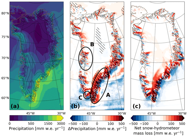
We present a new version of the polar Regional Atmospheric Climate Model (RACMO), version 2.4p1, and show first results for Greenland, Antarctica and the Arctic. We provide an overview of all changes and investigate the impact that they have on the climate of polar regions. By comparing the results with observations and the output from the previous model version, we show that the model performs well regarding the surface mass balance of the ice sheets and near-surface climate.
Veit Helm, Alireza Dehghanpour, Ronny Hänsch, Erik Loebel, Martin Horwath, and Angelika Humbert
The Cryosphere, 18, 3933–3970, https://doi.org/10.5194/tc-18-3933-2024, https://doi.org/10.5194/tc-18-3933-2024, 2024
Short summary
Short summary
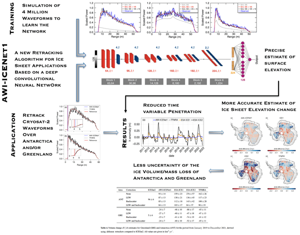
We present a new approach (AWI-ICENet1), based on a deep convolutional neural network, for analysing satellite radar altimeter measurements to accurately determine the surface height of ice sheets. Surface height estimates obtained with AWI-ICENet1 (along with related products, such as ice sheet height change and volume change) show improved and unbiased results compared to other products. This is important for the long-term monitoring of ice sheet mass loss and its impact on sea level rise.
Sara Arioli, Ghislain Picard, Laurent Arnaud, Simon Gascoin, Esteban Alonso-González, Marine Poizat, and Mark Irvine
Earth Syst. Sci. Data, 16, 3913–3934, https://doi.org/10.5194/essd-16-3913-2024, https://doi.org/10.5194/essd-16-3913-2024, 2024
Short summary
Short summary
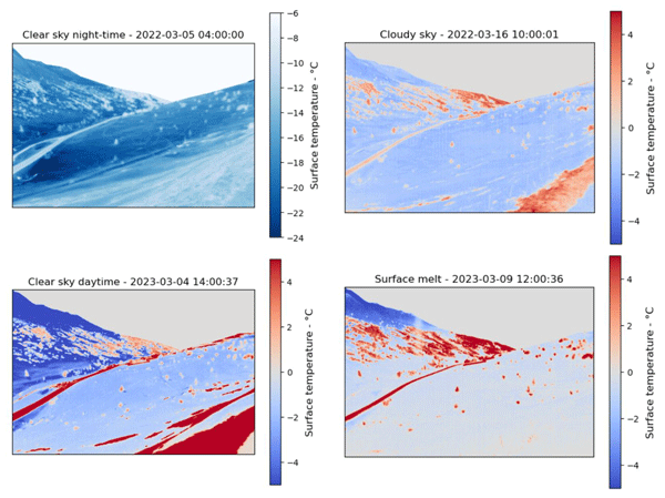
High-accuracy precision maps of the surface temperature of snow were acquired with an uncooled thermal-infrared camera during winter 2021–2022 and spring 2023. The accuracy – i.e., mean absolute error – improved from 1.28 K to 0.67 K between the seasons thanks to an improved camera setup and temperature stabilization. The dataset represents a major advance in the validation of satellite measurements and physical snow models over a complex topography.
Erik Loebel, Mirko Scheinert, Martin Horwath, Angelika Humbert, Julia Sohn, Konrad Heidler, Charlotte Liebezeit, and Xiao Xiang Zhu
The Cryosphere, 18, 3315–3332, https://doi.org/10.5194/tc-18-3315-2024, https://doi.org/10.5194/tc-18-3315-2024, 2024
Short summary
Short summary
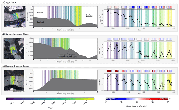
Comprehensive datasets of calving-front changes are essential for studying and modeling outlet glaciers. Current records are limited in temporal resolution due to manual delineation. We use deep learning to automatically delineate calving fronts for 23 glaciers in Greenland. Resulting time series resolve long-term, seasonal, and subseasonal patterns. We discuss the implications of our results and provide the cryosphere community with a data product and an implementation of our processing system.
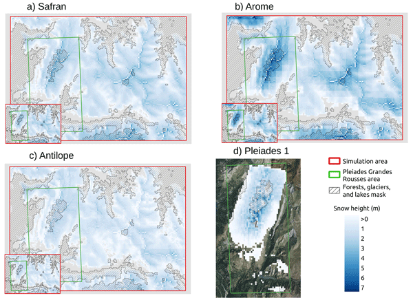
Ange Haddjeri, Matthieu Baron, Matthieu Lafaysse, Louis Le Toumelin, César Deschamps-Berger, Vincent Vionnet, Simon Gascoin, Matthieu Vernay, and Marie Dumont
The Cryosphere, 18, 3081–3116, https://doi.org/10.5194/tc-18-3081-2024, https://doi.org/10.5194/tc-18-3081-2024, 2024
Short summary
Short summary
Our study addresses the complex challenge of evaluating distributed alpine snow simulations with snow transport against snow depths from Pléiades stereo imagery and snow melt-out dates from Sentinel-2 and Landsat-8 satellites. Additionally, we disentangle error contributions between blowing snow, precipitation heterogeneity, and unresolved subgrid variability. Snow transport enhances the snow simulations at high elevations, while precipitation biases are the main error source in other areas.
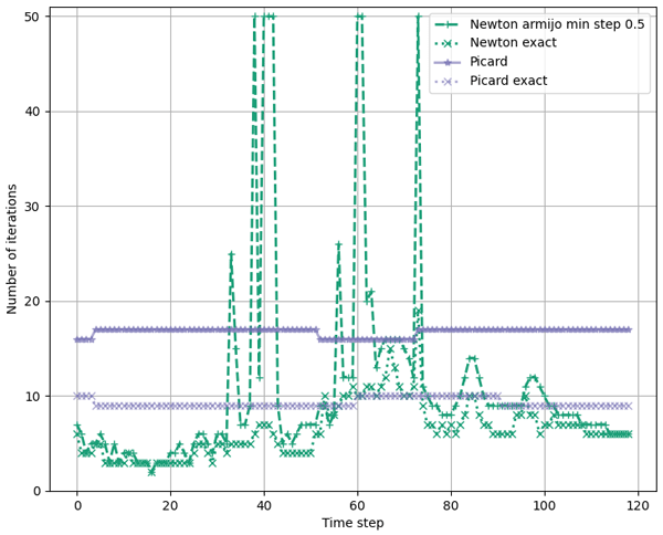
Niko Schmidt, Angelika Humbert, and Thomas Slawig
Geosci. Model Dev., 17, 4943–4959, https://doi.org/10.5194/gmd-17-4943-2024, https://doi.org/10.5194/gmd-17-4943-2024, 2024
Short summary
Short summary
Future sea-level rise is of big significance for coastal regions. The melting and acceleration of glaciers plays a major role in sea-level change. Computer simulation of glaciers costs a lot of computational resources. In this publication, we test a new way of simulating glaciers. This approach produces the same results but has the advantage that it needs much less computation time. As simulations can be obtained with fewer computation resources, higher resolution and physics become affordable.
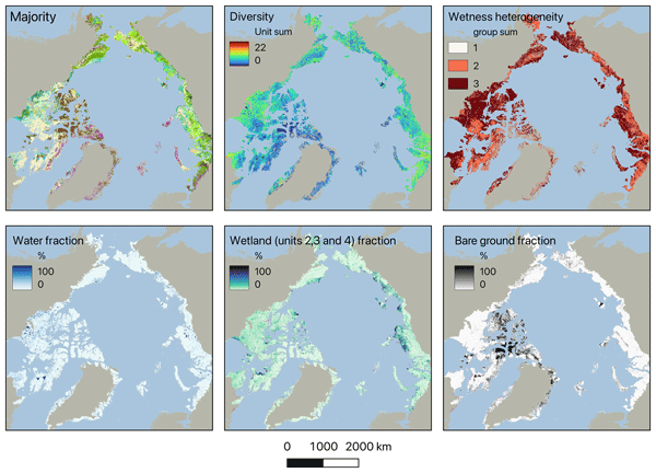
Annett Bartsch, Aleksandra Efimova, Barbara Widhalm, Xaver Muri, Clemens von Baeckmann, Helena Bergstedt, Ksenia Ermokhina, Gustaf Hugelius, Birgit Heim, and Marina Leibman
Hydrol. Earth Syst. Sci., 28, 2421–2481, https://doi.org/10.5194/hess-28-2421-2024, https://doi.org/10.5194/hess-28-2421-2024, 2024
Short summary
Short summary
Wetness gradients and landcover diversity for the entire Arctic tundra have been assessed using a novel satellite-data-based map. Patterns of lakes, wetlands, general soil moisture conditions and vegetation physiognomy are represented at 10 m. About 40 % of the area north of the treeline falls into three units of dry types, with limited shrub growth. Wetter regions have higher landcover diversity than drier regions.
Julien Meloche, Melody Sandells, Henning Löwe, Nick Rutter, Richard Essery, Ghislain Picard, Randall K. Scharien, Alexandre Langlois, Matthias Jaggi, Josh King, Peter Toose, Jérôme Bouffard, Alessandro Di Bella, and Michele Scagliola
EGUsphere, https://doi.org/10.5194/egusphere-2024-1583, https://doi.org/10.5194/egusphere-2024-1583, 2024
Preprint archived
Short summary
Short summary
Sea ice thickness is essential for climate studies. Radar altimetry has provided sea ice thickness measurement, but uncertainty arises from interaction of the signal with the snow cover. Therefore, modelling the signal interaction with the snow is necessary to improve retrieval. A radar model was used to simulate the radar signal from the snow-covered sea ice. This work paved the way to improved physical algorithm to retrieve snow depth and sea ice thickness for radar altimeter missions.
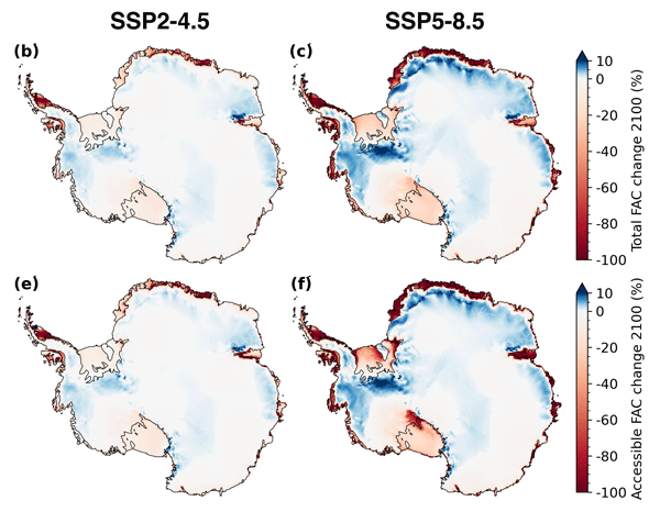
Sanne B. M. Veldhuijsen, Willem Jan van de Berg, Peter Kuipers Munneke, and Michiel R. van den Broeke
The Cryosphere, 18, 1983–1999, https://doi.org/10.5194/tc-18-1983-2024, https://doi.org/10.5194/tc-18-1983-2024, 2024
Short summary
Short summary
We use the IMAU firn densification model to simulate the 21st-century evolution of Antarctic firn air content. Ice shelves on the Antarctic Peninsula and the Roi Baudouin Ice Shelf in Dronning Maud Land are particularly vulnerable to total firn air content (FAC) depletion. Our results also underline the potentially large vulnerability of low-accumulation ice shelves to firn air depletion through ice slab formation.
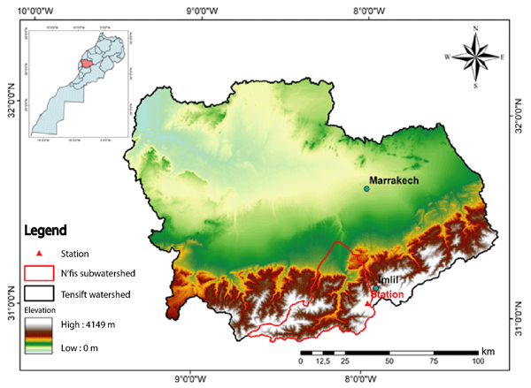
Lahoucine Hanich, Ouiaam Lahnik, Simon Gascoin, Adnane Chakir, and Vincent Simonneaux
Proc. IAHS, 385, 387–391, https://doi.org/10.5194/piahs-385-387-2024, https://doi.org/10.5194/piahs-385-387-2024, 2024
Short summary
Short summary
Using a dataset measured with the eddy covariance system (EC) for a period from September 2020 to January 2021 at the Tazaghart plateau, located in the High Atlas of Marrakech, the sublimation was estimated. The average daily sublimation rate measured was 0.41 mm per day. Measured sublimation accounted for 42 % and 40 % of snow ablation, based on the energy and water balances, respectively.
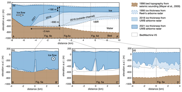
Ole Zeising, Niklas Neckel, Nils Dörr, Veit Helm, Daniel Steinhage, Ralph Timmermann, and Angelika Humbert
The Cryosphere, 18, 1333–1357, https://doi.org/10.5194/tc-18-1333-2024, https://doi.org/10.5194/tc-18-1333-2024, 2024
Short summary
Short summary
The 79° North Glacier in Greenland has experienced significant changes over the last decades. Due to extreme melt rates, the ice has thinned significantly in the vicinity of the grounding line, where a large subglacial channel has formed since 2010. We attribute these changes to warm ocean currents and increased subglacial discharge from surface melt. However, basal melting has decreased since 2018, indicating colder water inflow into the cavity below the glacier.
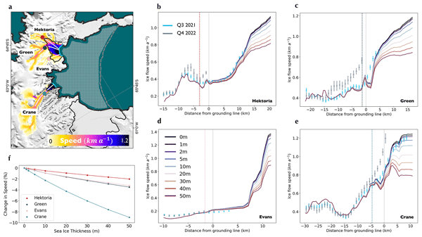
Trystan Surawy-Stepney, Anna E. Hogg, Stephen L. Cornford, Benjamin J. Wallis, Benjamin J. Davison, Heather L. Selley, Ross A. W. Slater, Elise K. Lie, Livia Jakob, Andrew Ridout, Noel Gourmelen, Bryony I. D. Freer, Sally F. Wilson, and Andrew Shepherd
The Cryosphere, 18, 977–993, https://doi.org/10.5194/tc-18-977-2024, https://doi.org/10.5194/tc-18-977-2024, 2024
Short summary
Short summary
Here, we use satellite observations and an ice flow model to quantify the impact of sea ice buttressing on ice streams on the Antarctic Peninsula. The evacuation of 11-year-old landfast sea ice in the Larsen B embayment on the East Antarctic Peninsula in January 2022 was closely followed by major changes in the calving behaviour and acceleration (30 %) of the ocean-terminating glaciers. Our results show that sea ice buttressing had a negligible direct role in the observed dynamic changes.
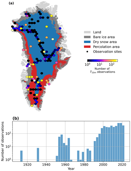
Baptiste Vandecrux, Robert S. Fausto, Jason E. Box, Federico Covi, Regine Hock, Åsa K. Rennermalm, Achim Heilig, Jakob Abermann, Dirk van As, Elisa Bjerre, Xavier Fettweis, Paul C. J. P. Smeets, Peter Kuipers Munneke, Michiel R. van den Broeke, Max Brils, Peter L. Langen, Ruth Mottram, and Andreas P. Ahlstrøm
The Cryosphere, 18, 609–631, https://doi.org/10.5194/tc-18-609-2024, https://doi.org/10.5194/tc-18-609-2024, 2024
Short summary
Short summary
How fast is the Greenland ice sheet warming? In this study, we compiled 4500+ temperature measurements at 10 m below the ice sheet surface (T10m) from 1912 to 2022. We trained a machine learning model on these data and reconstructed T10m for the ice sheet during 1950–2022. After a slight cooling during 1950–1985, the ice sheet warmed at a rate of 0.7 °C per decade until 2022. Climate models showed mixed results compared to our observations and underestimated the warming in key regions.
Esteban Alonso-González, Kristoffer Aalstad, Norbert Pirk, Marco Mazzolini, Désirée Treichler, Paul Leclercq, Sebastian Westermann, Juan Ignacio López-Moreno, and Simon Gascoin
Hydrol. Earth Syst. Sci., 27, 4637–4659, https://doi.org/10.5194/hess-27-4637-2023, https://doi.org/10.5194/hess-27-4637-2023, 2023
Short summary
Short summary
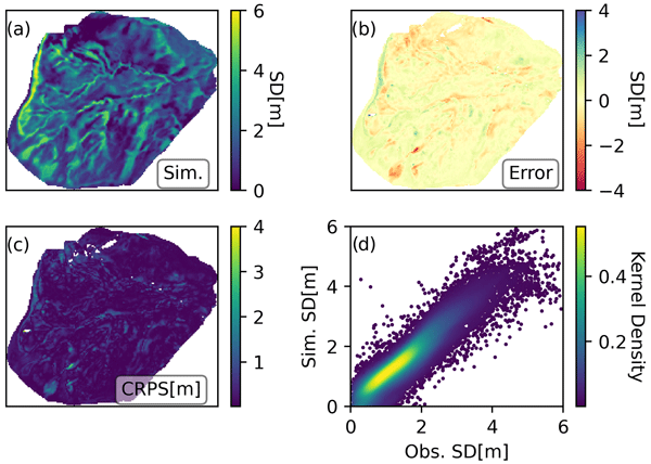
Here we explore how to improve hyper-resolution (5 m) distributed snowpack simulations using sparse observations, which do not provide information from all the areas of the simulation domain. We propose a new way of propagating information throughout the simulations adapted to the hyper-resolution, which could also be used to improve simulations of other nature. The method has been implemented in an open-source data assimilation tool that is readily accessible to everyone.
Hélène Seroussi, Vincent Verjans, Sophie Nowicki, Antony J. Payne, Heiko Goelzer, William H. Lipscomb, Ayako Abe-Ouchi, Cécile Agosta, Torsten Albrecht, Xylar Asay-Davis, Alice Barthel, Reinhard Calov, Richard Cullather, Christophe Dumas, Benjamin K. Galton-Fenzi, Rupert Gladstone, Nicholas R. Golledge, Jonathan M. Gregory, Ralf Greve, Tore Hattermann, Matthew J. Hoffman, Angelika Humbert, Philippe Huybrechts, Nicolas C. Jourdain, Thomas Kleiner, Eric Larour, Gunter R. Leguy, Daniel P. Lowry, Chistopher M. Little, Mathieu Morlighem, Frank Pattyn, Tyler Pelle, Stephen F. Price, Aurélien Quiquet, Ronja Reese, Nicole-Jeanne Schlegel, Andrew Shepherd, Erika Simon, Robin S. Smith, Fiammetta Straneo, Sainan Sun, Luke D. Trusel, Jonas Van Breedam, Peter Van Katwyk, Roderik S. W. van de Wal, Ricarda Winkelmann, Chen Zhao, Tong Zhang, and Thomas Zwinger
The Cryosphere, 17, 5197–5217, https://doi.org/10.5194/tc-17-5197-2023, https://doi.org/10.5194/tc-17-5197-2023, 2023
Short summary
Short summary
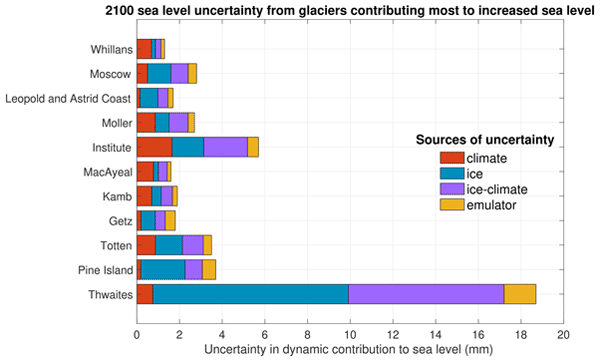
Mass loss from Antarctica is a key contributor to sea level rise over the 21st century, and the associated uncertainty dominates sea level projections. We highlight here the Antarctic glaciers showing the largest changes and quantify the main sources of uncertainty in their future evolution using an ensemble of ice flow models. We show that on top of Pine Island and Thwaites glaciers, Totten and Moscow University glaciers show rapid changes and a strong sensitivity to warmer ocean conditions.
Michael Wolovick, Angelika Humbert, Thomas Kleiner, and Martin Rückamp
The Cryosphere, 17, 5027–5060, https://doi.org/10.5194/tc-17-5027-2023, https://doi.org/10.5194/tc-17-5027-2023, 2023
Short summary
Short summary
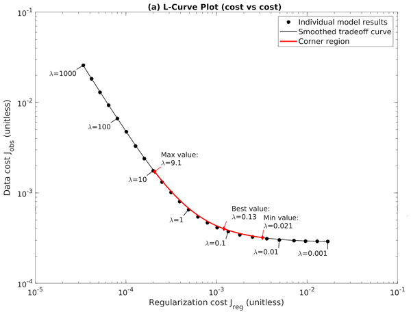
The friction underneath ice sheets can be inferred from observed velocity at the top, but this inference requires smoothing. The selection of smoothing has been highly variable in the literature. Here we show how to rigorously select the best smoothing, and we show that the inferred friction converges towards the best knowable field as model resolution improves. We use this to learn about the best description of basal friction and to formulate recommended best practices for other modelers.
Anne Braakmann-Folgmann, Andrew Shepherd, David Hogg, and Ella Redmond
The Cryosphere, 17, 4675–4690, https://doi.org/10.5194/tc-17-4675-2023, https://doi.org/10.5194/tc-17-4675-2023, 2023
Short summary
Short summary
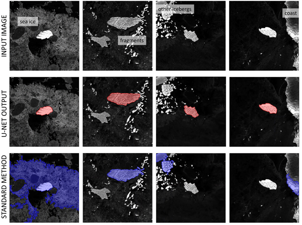
In this study, we propose a deep neural network to map the extent of giant Antarctic icebergs in Sentinel-1 images automatically. While each manual delineation requires several minutes, our U-net takes less than 0.01 s. In terms of accuracy, we find that U-net outperforms two standard segmentation techniques (Otsu, k-means) in most metrics and is more robust to challenging scenes with sea ice, coast and other icebergs. The absolute median deviation in iceberg area across 191 images is 4.1 %.
Lena G. Buth, Valeria Di Biase, Peter Kuipers Munneke, Stef Lhermitte, Sanne B. M. Veldhuijsen, Sophie de Roda Husman, Michiel R. van den Broeke, and Bert Wouters
EGUsphere, https://doi.org/10.5194/egusphere-2023-2000, https://doi.org/10.5194/egusphere-2023-2000, 2023
Preprint archived
Short summary
Short summary
Liquid meltwater which is stored in air bubbles in the compacted snow near the surface of Antarctica can affect ice shelf stability. In order to detect the presence of such firn aquifers over large scales, satellite remote sensing is needed. In this paper, we present our new detection method using radar satellite data as well as the results for the whole Antarctic Peninsula. Firn aquifers are found in the north and northwest of the peninsula, in agreement with locations predicted by models.
Yannic Fischler, Thomas Kleiner, Christian Bischof, Jeremie Schmiedel, Roiy Sayag, Raban Emunds, Lennart Frederik Oestreich, and Angelika Humbert
Geosci. Model Dev., 16, 5305–5322, https://doi.org/10.5194/gmd-16-5305-2023, https://doi.org/10.5194/gmd-16-5305-2023, 2023
Short summary
Short summary
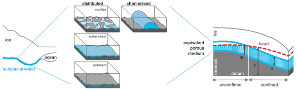
Water underneath ice sheets affects the motion of glaciers. This study presents a newly developed code, CUAS-MPI, that simulates subglacial hydrology. It is designed for supercomputers and is hence a parallelized code. We measure the performance of this code for simulations of the entire Greenland Ice Sheet and find that the code works efficiently. Moreover, we validated the code to ensure the correctness of the solution. CUAS-MPI opens new possibilities for simulations of ice sheet hydrology.
Ole Baltazar Andersen, Stine Kildegaard Rose, Adili Abulaitijiang, Shengjun Zhang, and Sara Fleury
Earth Syst. Sci. Data, 15, 4065–4075, https://doi.org/10.5194/essd-15-4065-2023, https://doi.org/10.5194/essd-15-4065-2023, 2023
Short summary
Short summary
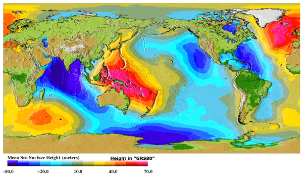
The mean sea surface (MSS) is an important reference for mapping sea-level changes across the global oceans. It is widely used by space agencies in the definition of sea-level anomalies as mapped by satellite altimetry from space. Here a new fully global high-resolution mean sea surface called DTU21MSS is presented, and a suite of evaluations are performed to demonstrate its performance.
Esteban Alonso-González, Simon Gascoin, Sara Arioli, and Ghislain Picard
The Cryosphere, 17, 3329–3342, https://doi.org/10.5194/tc-17-3329-2023, https://doi.org/10.5194/tc-17-3329-2023, 2023
Short summary
Short summary
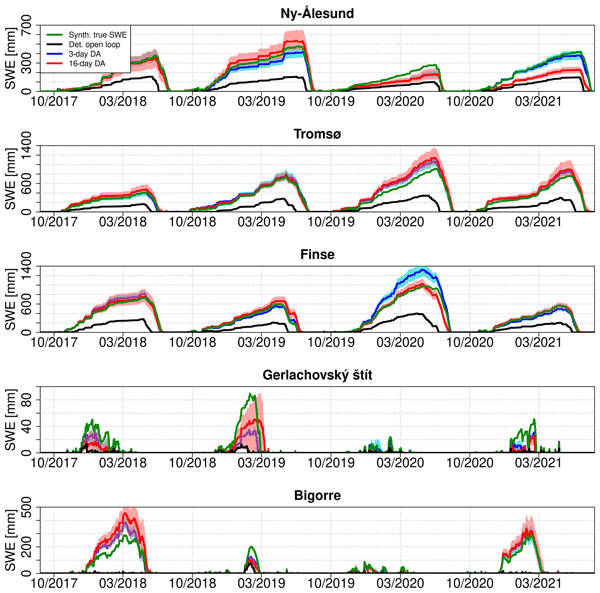
Data assimilation techniques are a promising approach to improve snowpack simulations in remote areas that are difficult to monitor. This paper studies the ability of satellite-observed land surface temperature to improve snowpack simulations through data assimilation. We show that it is possible to improve snowpack simulations, but the temporal resolution of the observations and the algorithm used are critical to obtain satisfactory results.
Marion Bocquet, Sara Fleury, Fanny Piras, Eero Rinne, Heidi Sallila, Florent Garnier, and Frédérique Rémy
The Cryosphere, 17, 3013–3039, https://doi.org/10.5194/tc-17-3013-2023, https://doi.org/10.5194/tc-17-3013-2023, 2023
Short summary
Short summary
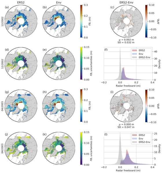
Sea ice has a large interannual variability, and studying its evolution requires long time series of observations. In this paper, we propose the first method to extend Arctic sea ice thickness time series to the ERS-2 altimeter. The developed method is based on a neural network to calibrate past missions on the current one by taking advantage of their differences during the mission-overlap periods. Data are available as monthly maps for each year during the winter period between 1995 and 2021.
Marie Dumont, Simon Gascoin, Marion Réveillet, Didier Voisin, François Tuzet, Laurent Arnaud, Mylène Bonnefoy, Montse Bacardit Peñarroya, Carlo Carmagnola, Alexandre Deguine, Aurélie Diacre, Lukas Dürr, Olivier Evrard, Firmin Fontaine, Amaury Frankl, Mathieu Fructus, Laure Gandois, Isabelle Gouttevin, Abdelfateh Gherab, Pascal Hagenmuller, Sophia Hansson, Hervé Herbin, Béatrice Josse, Bruno Jourdain, Irene Lefevre, Gaël Le Roux, Quentin Libois, Lucie Liger, Samuel Morin, Denis Petitprez, Alvaro Robledano, Martin Schneebeli, Pascal Salze, Delphine Six, Emmanuel Thibert, Jürg Trachsel, Matthieu Vernay, Léo Viallon-Galinier, and Céline Voiron
Earth Syst. Sci. Data, 15, 3075–3094, https://doi.org/10.5194/essd-15-3075-2023, https://doi.org/10.5194/essd-15-3075-2023, 2023
Short summary
Short summary
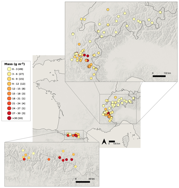
Saharan dust outbreaks have profound effects on ecosystems, climate, health, and the cryosphere, but the spatial deposition pattern of Saharan dust is poorly known. Following the extreme dust deposition event of February 2021 across Europe, a citizen science campaign was launched to sample dust on snow over the Pyrenees and the European Alps. This campaign triggered wide interest and over 100 samples. The samples revealed the high variability of the dust properties within a single event.
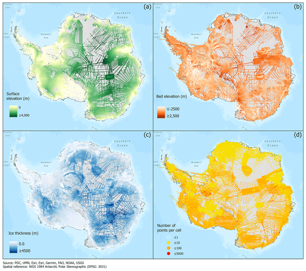
Alice C. Frémand, Peter Fretwell, Julien A. Bodart, Hamish D. Pritchard, Alan Aitken, Jonathan L. Bamber, Robin Bell, Cesidio Bianchi, Robert G. Bingham, Donald D. Blankenship, Gino Casassa, Ginny Catania, Knut Christianson, Howard Conway, Hugh F. J. Corr, Xiangbin Cui, Detlef Damaske, Volkmar Damm, Reinhard Drews, Graeme Eagles, Olaf Eisen, Hannes Eisermann, Fausto Ferraccioli, Elena Field, René Forsberg, Steven Franke, Shuji Fujita, Yonggyu Gim, Vikram Goel, Siva Prasad Gogineni, Jamin Greenbaum, Benjamin Hills, Richard C. A. Hindmarsh, Andrew O. Hoffman, Per Holmlund, Nicholas Holschuh, John W. Holt, Annika N. Horlings, Angelika Humbert, Robert W. Jacobel, Daniela Jansen, Adrian Jenkins, Wilfried Jokat, Tom Jordan, Edward King, Jack Kohler, William Krabill, Mette Kusk Gillespie, Kirsty Langley, Joohan Lee, German Leitchenkov, Carlton Leuschen, Bruce Luyendyk, Joseph MacGregor, Emma MacKie, Kenichi Matsuoka, Mathieu Morlighem, Jérémie Mouginot, Frank O. Nitsche, Yoshifumi Nogi, Ole A. Nost, John Paden, Frank Pattyn, Sergey V. Popov, Eric Rignot, David M. Rippin, Andrés Rivera, Jason Roberts, Neil Ross, Anotonia Ruppel, Dustin M. Schroeder, Martin J. Siegert, Andrew M. Smith, Daniel Steinhage, Michael Studinger, Bo Sun, Ignazio Tabacco, Kirsty Tinto, Stefano Urbini, David Vaughan, Brian C. Welch, Douglas S. Wilson, Duncan A. Young, and Achille Zirizzotti
Earth Syst. Sci. Data, 15, 2695–2710, https://doi.org/10.5194/essd-15-2695-2023, https://doi.org/10.5194/essd-15-2695-2023, 2023
Short summary
Short summary
This paper presents the release of over 60 years of ice thickness, bed elevation, and surface elevation data acquired over Antarctica by the international community. These data are a crucial component of the Antarctic Bedmap initiative which aims to produce a new map and datasets of Antarctic ice thickness and bed topography for the international glaciology and geophysical community.
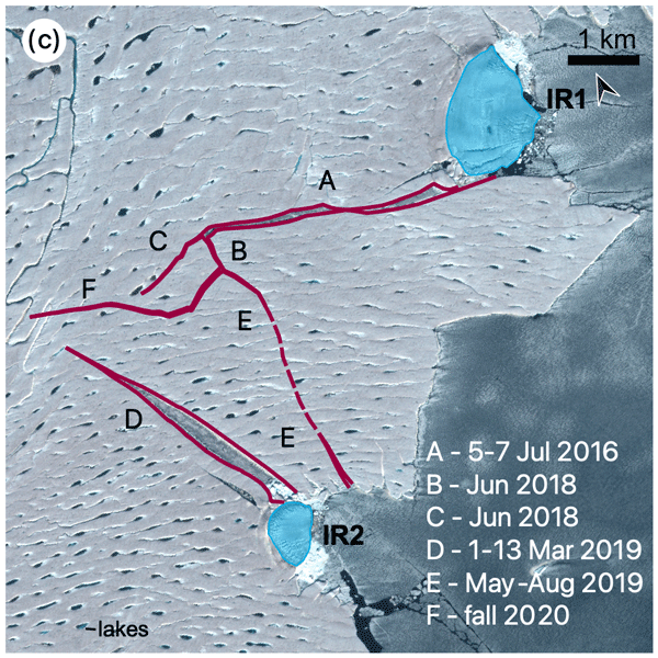
Angelika Humbert, Veit Helm, Niklas Neckel, Ole Zeising, Martin Rückamp, Shfaqat Abbas Khan, Erik Loebel, Jörg Brauchle, Karsten Stebner, Dietmar Gross, Rabea Sondershaus, and Ralf Müller
The Cryosphere, 17, 2851–2870, https://doi.org/10.5194/tc-17-2851-2023, https://doi.org/10.5194/tc-17-2851-2023, 2023
Short summary
Short summary
The largest floating glacier mass in Greenland, the 79° N Glacier, is showing signs of instability. We investigate how crack formation at the glacier's calving front has changed over the last decades by using satellite imagery and airborne data. The calving front is about to lose contact to stabilizing ice islands. Simulations show that the glacier will accelerate as a result of this, leading to an increase in ice discharge of more than 5.1 % if its calving front retreats by 46 %.
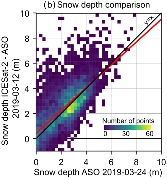
César Deschamps-Berger, Simon Gascoin, David Shean, Hannah Besso, Ambroise Guiot, and Juan Ignacio López-Moreno
The Cryosphere, 17, 2779–2792, https://doi.org/10.5194/tc-17-2779-2023, https://doi.org/10.5194/tc-17-2779-2023, 2023
Short summary
Short summary
The estimation of the snow depth in mountains is hard, despite the importance of the snowpack for human societies and ecosystems. We measured the snow depth in mountains by comparing the elevation of points measured with snow from the high-precision altimetric satellite ICESat-2 to the elevation without snow from various sources. Snow depths derived only from ICESat-2 were too sparse, but using external airborne/satellite products results in spatially richer and sufficiently precise snow depths.

Vishnu Nandan, Rosemary Willatt, Robbie Mallett, Julienne Stroeve, Torsten Geldsetzer, Randall Scharien, Rasmus Tonboe, John Yackel, Jack Landy, David Clemens-Sewall, Arttu Jutila, David N. Wagner, Daniela Krampe, Marcus Huntemann, Mallik Mahmud, David Jensen, Thomas Newman, Stefan Hendricks, Gunnar Spreen, Amy Macfarlane, Martin Schneebeli, James Mead, Robert Ricker, Michael Gallagher, Claude Duguay, Ian Raphael, Chris Polashenski, Michel Tsamados, Ilkka Matero, and Mario Hoppmann
The Cryosphere, 17, 2211–2229, https://doi.org/10.5194/tc-17-2211-2023, https://doi.org/10.5194/tc-17-2211-2023, 2023
Short summary
Short summary
We show that wind redistributes snow on Arctic sea ice, and Ka- and Ku-band radar measurements detect both newly deposited snow and buried snow layers that can affect the accuracy of snow depth estimates on sea ice. Radar, laser, meteorological, and snow data were collected during the MOSAiC expedition. With frequent occurrence of storms in the Arctic, our results show that
wind-redistributed snow needs to be accounted for to improve snow depth estimates on sea ice from satellite radars.
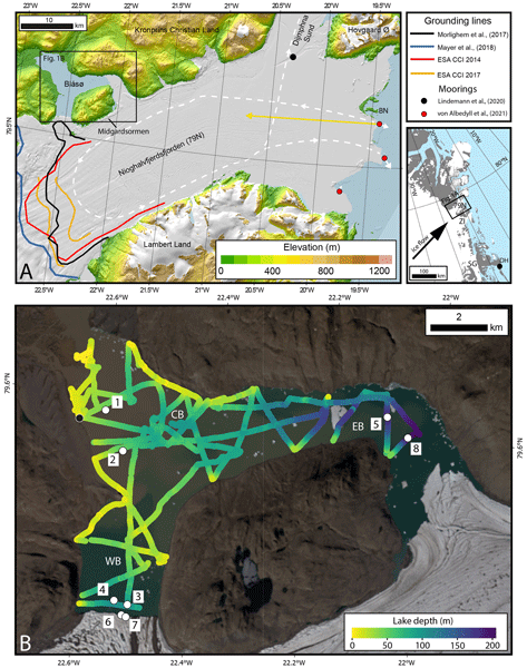
Michael J. Bentley, James A. Smith, Stewart S. R. Jamieson, Margaret R. Lindeman, Brice R. Rea, Angelika Humbert, Timothy P. Lane, Christopher M. Darvill, Jeremy M. Lloyd, Fiamma Straneo, Veit Helm, and David H. Roberts
The Cryosphere, 17, 1821–1837, https://doi.org/10.5194/tc-17-1821-2023, https://doi.org/10.5194/tc-17-1821-2023, 2023
Short summary
Short summary
The Northeast Greenland Ice Stream is a major outlet of the Greenland Ice Sheet. Some of its outlet glaciers and ice shelves have been breaking up and retreating, with inflows of warm ocean water identified as the likely reason. Here we report direct measurements of warm ocean water in an unusual lake that is connected to the ocean beneath the ice shelf in front of the 79° N Glacier. This glacier has not yet shown much retreat, but the presence of warm water makes future retreat more likely.
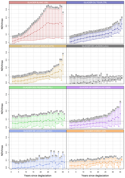
Arthur Bayle, Bradley Z. Carlson, Anaïs Zimmer, Sophie Vallée, Antoine Rabatel, Edoardo Cremonese, Gianluca Filippa, Cédric Dentant, Christophe Randin, Andrea Mainetti, Erwan Roussel, Simon Gascoin, Dov Corenblit, and Philippe Choler
Biogeosciences, 20, 1649–1669, https://doi.org/10.5194/bg-20-1649-2023, https://doi.org/10.5194/bg-20-1649-2023, 2023
Short summary
Short summary
Glacier forefields have long provided ecologists with a model to study patterns of plant succession following glacier retreat. We used remote sensing approaches to study early succession dynamics as it allows to analyze the deglaciation, colonization, and vegetation growth within a single framework. We found that the heterogeneity of early succession dynamics is deterministic and can be explained well by local environmental context. This work has been done by an international consortium.
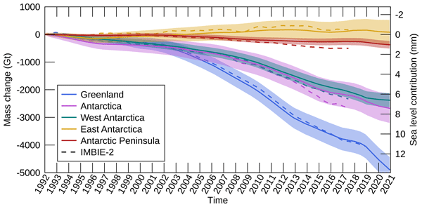
Inès N. Otosaka, Andrew Shepherd, Erik R. Ivins, Nicole-Jeanne Schlegel, Charles Amory, Michiel R. van den Broeke, Martin Horwath, Ian Joughin, Michalea D. King, Gerhard Krinner, Sophie Nowicki, Anthony J. Payne, Eric Rignot, Ted Scambos, Karen M. Simon, Benjamin E. Smith, Louise S. Sørensen, Isabella Velicogna, Pippa L. Whitehouse, Geruo A, Cécile Agosta, Andreas P. Ahlstrøm, Alejandro Blazquez, William Colgan, Marcus E. Engdahl, Xavier Fettweis, Rene Forsberg, Hubert Gallée, Alex Gardner, Lin Gilbert, Noel Gourmelen, Andreas Groh, Brian C. Gunter, Christopher Harig, Veit Helm, Shfaqat Abbas Khan, Christoph Kittel, Hannes Konrad, Peter L. Langen, Benoit S. Lecavalier, Chia-Chun Liang, Bryant D. Loomis, Malcolm McMillan, Daniele Melini, Sebastian H. Mernild, Ruth Mottram, Jeremie Mouginot, Johan Nilsson, Brice Noël, Mark E. Pattle, William R. Peltier, Nadege Pie, Mònica Roca, Ingo Sasgen, Himanshu V. Save, Ki-Weon Seo, Bernd Scheuchl, Ernst J. O. Schrama, Ludwig Schröder, Sebastian B. Simonsen, Thomas Slater, Giorgio Spada, Tyler C. Sutterley, Bramha Dutt Vishwakarma, Jan Melchior van Wessem, David Wiese, Wouter van der Wal, and Bert Wouters
Earth Syst. Sci. Data, 15, 1597–1616, https://doi.org/10.5194/essd-15-1597-2023, https://doi.org/10.5194/essd-15-1597-2023, 2023
Short summary
Short summary
By measuring changes in the volume, gravitational attraction, and ice flow of Greenland and Antarctica from space, we can monitor their mass gain and loss over time. Here, we present a new record of the Earth’s polar ice sheet mass balance produced by aggregating 50 satellite-based estimates of ice sheet mass change. This new assessment shows that the ice sheets have lost (7.5 x 10¹²) t of ice between 1992 and 2020, contributing 21 mm to sea level rise.

Sanne B. M. Veldhuijsen, Willem Jan van de Berg, Max Brils, Peter Kuipers Munneke, and Michiel R. van den Broeke
The Cryosphere, 17, 1675–1696, https://doi.org/10.5194/tc-17-1675-2023, https://doi.org/10.5194/tc-17-1675-2023, 2023
Short summary
Short summary
Firn is the transition of snow to glacier ice and covers 99 % of the Antarctic ice sheet. Knowledge about the firn layer and its variability is important, as it impacts satellite-based estimates of ice sheet mass change. Also, firn contains pores in which nearly all of the surface melt is retained. Here, we improve a semi-empirical firn model and simulate the firn characteristics for the period 1979–2020. We evaluate the performance with field and satellite measures and test its sensitivity.
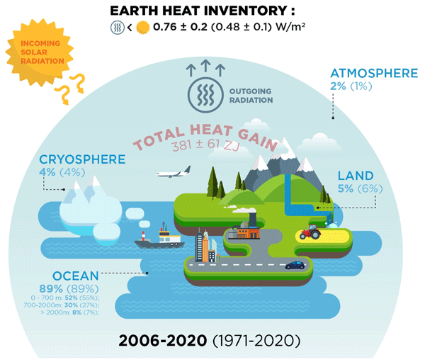
Karina von Schuckmann, Audrey Minière, Flora Gues, Francisco José Cuesta-Valero, Gottfried Kirchengast, Susheel Adusumilli, Fiammetta Straneo, Michaël Ablain, Richard P. Allan, Paul M. Barker, Hugo Beltrami, Alejandro Blazquez, Tim Boyer, Lijing Cheng, John Church, Damien Desbruyeres, Han Dolman, Catia M. Domingues, Almudena García-García, Donata Giglio, John E. Gilson, Maximilian Gorfer, Leopold Haimberger, Maria Z. Hakuba, Stefan Hendricks, Shigeki Hosoda, Gregory C. Johnson, Rachel Killick, Brian King, Nicolas Kolodziejczyk, Anton Korosov, Gerhard Krinner, Mikael Kuusela, Felix W. Landerer, Moritz Langer, Thomas Lavergne, Isobel Lawrence, Yuehua Li, John Lyman, Florence Marti, Ben Marzeion, Michael Mayer, Andrew H. MacDougall, Trevor McDougall, Didier Paolo Monselesan, Jan Nitzbon, Inès Otosaka, Jian Peng, Sarah Purkey, Dean Roemmich, Kanako Sato, Katsunari Sato, Abhishek Savita, Axel Schweiger, Andrew Shepherd, Sonia I. Seneviratne, Leon Simons, Donald A. Slater, Thomas Slater, Andrea K. Steiner, Toshio Suga, Tanguy Szekely, Wim Thiery, Mary-Louise Timmermans, Inne Vanderkelen, Susan E. Wjiffels, Tonghua Wu, and Michael Zemp
Earth Syst. Sci. Data, 15, 1675–1709, https://doi.org/10.5194/essd-15-1675-2023, https://doi.org/10.5194/essd-15-1675-2023, 2023
Short summary
Short summary
Earth's climate is out of energy balance, and this study quantifies how much heat has consequently accumulated over the past decades (ocean: 89 %, land: 6 %, cryosphere: 4 %, atmosphere: 1 %). Since 1971, this accumulated heat reached record values at an increasing pace. The Earth heat inventory provides a comprehensive view on the status and expectation of global warming, and we call for an implementation of this global climate indicator into the Paris Agreement’s Global Stocktake.
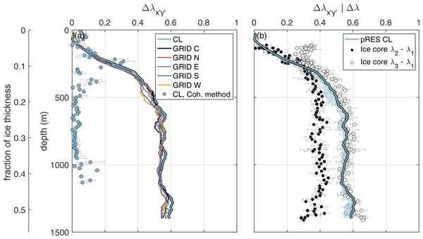
Ole Zeising, Tamara Annina Gerber, Olaf Eisen, M. Reza Ershadi, Nicolas Stoll, Ilka Weikusat, and Angelika Humbert
The Cryosphere, 17, 1097–1105, https://doi.org/10.5194/tc-17-1097-2023, https://doi.org/10.5194/tc-17-1097-2023, 2023
Short summary
Short summary
The flow of glaciers and ice streams is influenced by crystal fabric orientation. Besides sparse ice cores, these can be investigated by radar measurements. Here, we present an improved method which allows us to infer the horizontal fabric asymmetry using polarimetric phase-sensitive radar data. A validation of the method on a deep ice core from the Greenland Ice Sheet shows an excellent agreement, which is a large improvement over previously used methods.
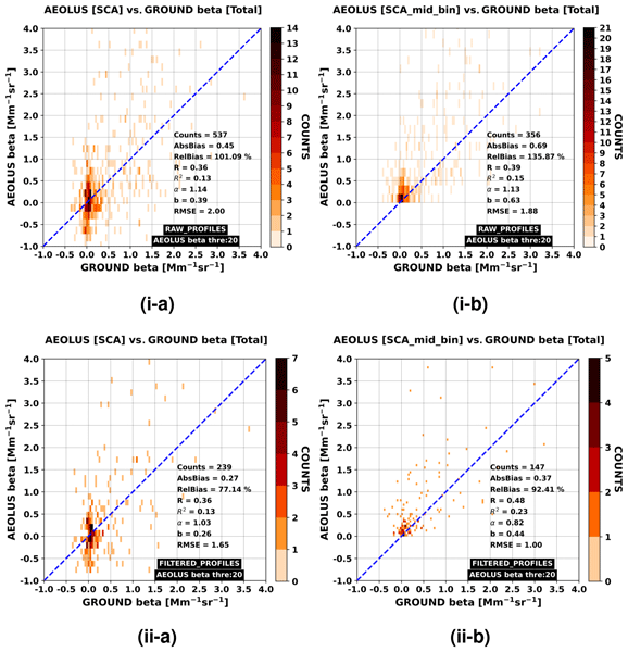
Antonis Gkikas, Anna Gialitaki, Ioannis Binietoglou, Eleni Marinou, Maria Tsichla, Nikolaos Siomos, Peristera Paschou, Anna Kampouri, Kalliopi Artemis Voudouri, Emmanouil Proestakis, Maria Mylonaki, Christina-Anna Papanikolaou, Konstantinos Michailidis, Holger Baars, Anne Grete Straume, Dimitris Balis, Alexandros Papayannis, Tomasso Parrinello, and Vassilis Amiridis
Atmos. Meas. Tech., 16, 1017–1042, https://doi.org/10.5194/amt-16-1017-2023, https://doi.org/10.5194/amt-16-1017-2023, 2023
Short summary
Short summary
We perform an assessment analysis of the Aeolus Standard Correct Algorithm (SCA) backscatter coefficient retrievals against reference observations acquired at three Greek lidar stations (Athens, Thessaloniki and Antikythera) of the PANACEA network. Overall, 43 cases are analysed, whereas specific aerosol scenarios in the vicinity of Antikythera island (SW Greece) are emphasised. All key Cal/Val aspects and recommendations, and the ongoing related activities, are thoroughly discussed.
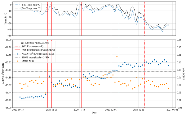
Annett Bartsch, Helena Bergstedt, Georg Pointner, Xaver Muri, Kimmo Rautiainen, Leena Leppänen, Kyle Joly, Aleksandr Sokolov, Pavel Orekhov, Dorothee Ehrich, and Eeva Mariatta Soininen
The Cryosphere, 17, 889–915, https://doi.org/10.5194/tc-17-889-2023, https://doi.org/10.5194/tc-17-889-2023, 2023
Short summary
Short summary
Rain-on-snow (ROS) events occur across many regions of the terrestrial Arctic in mid-winter. In extreme cases ice layers form which affect wildlife, vegetation and soils beyond the duration of the event. The fusion of multiple types of microwave satellite observations is suggested for the creation of a climate data record. Retrieval is most robust in the tundra biome, where records can be used to identify extremes and the results can be applied to impact studies at regional scale.
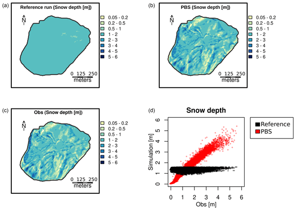
Esteban Alonso-González, Kristoffer Aalstad, Mohamed Wassim Baba, Jesús Revuelto, Juan Ignacio López-Moreno, Joel Fiddes, Richard Essery, and Simon Gascoin
Geosci. Model Dev., 15, 9127–9155, https://doi.org/10.5194/gmd-15-9127-2022, https://doi.org/10.5194/gmd-15-9127-2022, 2022
Short summary
Short summary
Snow cover plays an important role in many processes, but its monitoring is a challenging task. The alternative is usually to simulate the snowpack, and to improve these simulations one of the most promising options is to fuse simulations with available observations (data assimilation). In this paper we present MuSA, a data assimilation tool which facilitates the implementation of snow monitoring initiatives, allowing the assimilation of a wide variety of remotely sensed snow cover information.
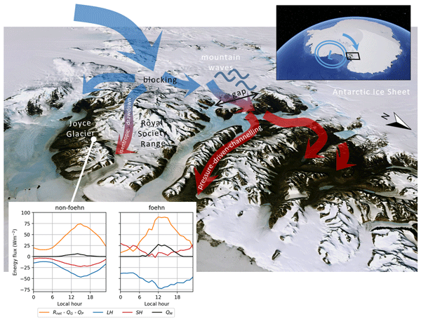
Marte G. Hofsteenge, Nicolas J. Cullen, Carleen H. Reijmer, Michiel van den Broeke, Marwan Katurji, and John F. Orwin
The Cryosphere, 16, 5041–5059, https://doi.org/10.5194/tc-16-5041-2022, https://doi.org/10.5194/tc-16-5041-2022, 2022
Short summary
Short summary
In the McMurdo Dry Valleys (MDV), foehn winds can impact glacial meltwater production and the fragile ecosystem that depends on it. We study these dry and warm winds at Joyce Glacier and show they are caused by a different mechanism than that found for nearby valleys, demonstrating the complex interaction of large-scale winds with the mountains in the MDV. We find that foehn winds increase sublimation of ice, increase heating from the atmosphere, and increase the occurrence and rates of melt.
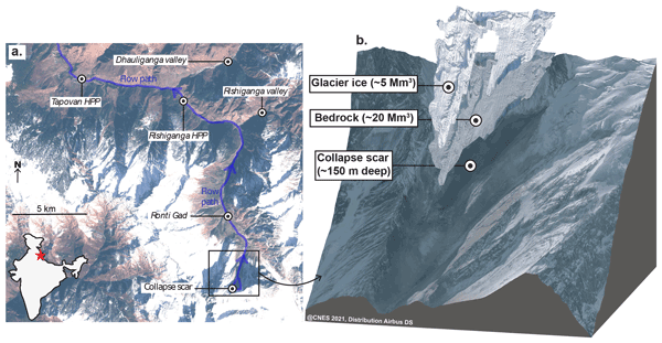
Maximillian Van Wyk de Vries, Shashank Bhushan, Mylène Jacquemart, César Deschamps-Berger, Etienne Berthier, Simon Gascoin, David E. Shean, Dan H. Shugar, and Andreas Kääb
Nat. Hazards Earth Syst. Sci., 22, 3309–3327, https://doi.org/10.5194/nhess-22-3309-2022, https://doi.org/10.5194/nhess-22-3309-2022, 2022
Short summary
Short summary
On 7 February 2021, a large rock–ice avalanche occurred in Chamoli, Indian Himalaya. The resulting debris flow swept down the nearby valley, leaving over 200 people dead or missing. We use a range of satellite datasets to investigate how the collapse area changed prior to collapse. We show that signs of instability were visible as early 5 years prior to collapse. However, it would likely not have been possible to predict the timing of the event from current satellite datasets.
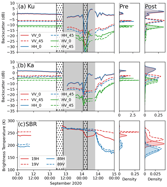
Julienne Stroeve, Vishnu Nandan, Rosemary Willatt, Ruzica Dadic, Philip Rostosky, Michael Gallagher, Robbie Mallett, Andrew Barrett, Stefan Hendricks, Rasmus Tonboe, Michelle McCrystall, Mark Serreze, Linda Thielke, Gunnar Spreen, Thomas Newman, John Yackel, Robert Ricker, Michel Tsamados, Amy Macfarlane, Henna-Reetta Hannula, and Martin Schneebeli
The Cryosphere, 16, 4223–4250, https://doi.org/10.5194/tc-16-4223-2022, https://doi.org/10.5194/tc-16-4223-2022, 2022
Short summary
Short summary
Impacts of rain on snow (ROS) on satellite-retrieved sea ice variables remain to be fully understood. This study evaluates the impacts of ROS over sea ice on active and passive microwave data collected during the 2019–20 MOSAiC expedition. Rainfall and subsequent refreezing of the snowpack significantly altered emitted and backscattered radar energy, laying important groundwork for understanding their impacts on operational satellite retrievals of various sea ice geophysical variables.
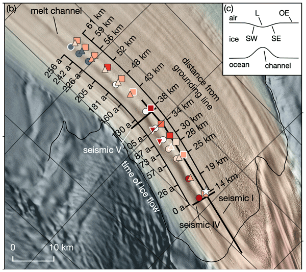
Angelika Humbert, Julia Christmann, Hugh F. J. Corr, Veit Helm, Lea-Sophie Höyns, Coen Hofstede, Ralf Müller, Niklas Neckel, Keith W. Nicholls, Timm Schultz, Daniel Steinhage, Michael Wolovick, and Ole Zeising
The Cryosphere, 16, 4107–4139, https://doi.org/10.5194/tc-16-4107-2022, https://doi.org/10.5194/tc-16-4107-2022, 2022
Short summary
Short summary
Ice shelves are normally flat structures that fringe the Antarctic continent. At some locations they have channels incised into their underside. On Filchner Ice Shelf, such a channel is more than 50 km long and up to 330 m high. We conducted field measurements of basal melt rates and found a maximum of 2 m yr−1. Simulations represent the geometry evolution of the channel reasonably well. There is no reason to assume that this type of melt channel is destabilizing ice shelves.
Lena G. Buth, Bert Wouters, Sanne B. M. Veldhuijsen, Stef Lhermitte, Peter Kuipers Munneke, and Michiel R. van den Broeke
The Cryosphere Discuss., https://doi.org/10.5194/tc-2022-127, https://doi.org/10.5194/tc-2022-127, 2022
Manuscript not accepted for further review
Short summary
Short summary
Liquid meltwater which is stored in air bubbles in the compacted snow near the surface of Antarctica can affect ice shelf stability. In order to detect the presence of such firn aquifers over large scales, satellite remote sensing is needed. In this paper, we present our new detection method using radar satellite data as well as the results for the whole Antarctic Peninsula. Firn aquifers are found in the north and northwest of the peninsula, in agreement with locations predicted by models.
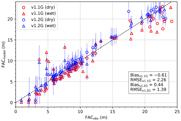
Max Brils, Peter Kuipers Munneke, Willem Jan van de Berg, and Michiel van den Broeke
Geosci. Model Dev., 15, 7121–7138, https://doi.org/10.5194/gmd-15-7121-2022, https://doi.org/10.5194/gmd-15-7121-2022, 2022
Short summary
Short summary
Firn covers the Greenland ice sheet (GrIS) and can temporarily prevent mass loss. Here, we present the latest version of our firn model, IMAU-FDM, with an application to the GrIS. We improved the density of fallen snow, the firn densification rate and the firn's thermal conductivity. This leads to a higher air content and 10 m temperatures. Furthermore we investigate three case studies and find that the updated model shows greater variability and an increased sensitivity in surface elevation.
Juha Lemmetyinen, Juval Cohen, Anna Kontu, Juho Vehviläinen, Henna-Reetta Hannula, Ioanna Merkouriadi, Stefan Scheiblauer, Helmut Rott, Thomas Nagler, Elisabeth Ripper, Kelly Elder, Hans-Peter Marshall, Reinhard Fromm, Marc Adams, Chris Derksen, Joshua King, Adriano Meta, Alex Coccia, Nick Rutter, Melody Sandells, Giovanni Macelloni, Emanuele Santi, Marion Leduc-Leballeur, Richard Essery, Cecile Menard, and Michael Kern
Earth Syst. Sci. Data, 14, 3915–3945, https://doi.org/10.5194/essd-14-3915-2022, https://doi.org/10.5194/essd-14-3915-2022, 2022
Short summary
Short summary
The manuscript describes airborne, dual-polarised X and Ku band synthetic aperture radar (SAR) data collected over several campaigns over snow-covered terrain in Finland, Austria and Canada. Colocated snow and meteorological observations are also presented. The data are meant for science users interested in investigating X/Ku band radar signatures from natural environments in winter conditions.

Juha Karvonen, Eero Rinne, Heidi Sallila, Petteri Uotila, and Marko Mäkynen
The Cryosphere, 16, 1821–1844, https://doi.org/10.5194/tc-16-1821-2022, https://doi.org/10.5194/tc-16-1821-2022, 2022
Short summary
Short summary
We propose a method to provide sea ice thickness (SIT) estimates over a test area in the Arctic utilizing radar altimeter (RA) measurement lines and C-band SAR imagery. The RA data are from CryoSat-2, and SAR imagery is from Sentinel-1. By combining them we get a SIT grid covering the whole test area instead of only narrow measurement lines from RA. This kind of SIT estimation can be extended to cover the whole Arctic (and Antarctic) for operational SIT monitoring.
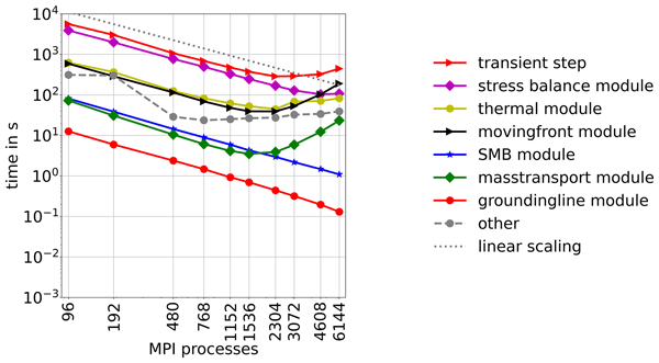
Yannic Fischler, Martin Rückamp, Christian Bischof, Vadym Aizinger, Mathieu Morlighem, and Angelika Humbert
Geosci. Model Dev., 15, 3753–3771, https://doi.org/10.5194/gmd-15-3753-2022, https://doi.org/10.5194/gmd-15-3753-2022, 2022
Short summary
Short summary
Ice sheet models are used to simulate the changes of ice sheets in future but are currently often run in coarse resolution and/or with neglecting important physics to make them affordable in terms of computational costs. We conducted a study simulating the Greenland Ice Sheet in high resolution and adequate physics to test where the ISSM ice sheet code is using most time and what could be done to improve its performance for future computer architectures that allow massive parallel computing.
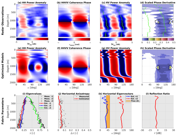
M. Reza Ershadi, Reinhard Drews, Carlos Martín, Olaf Eisen, Catherine Ritz, Hugh Corr, Julia Christmann, Ole Zeising, Angelika Humbert, and Robert Mulvaney
The Cryosphere, 16, 1719–1739, https://doi.org/10.5194/tc-16-1719-2022, https://doi.org/10.5194/tc-16-1719-2022, 2022
Short summary
Short summary
Radio waves transmitted through ice split up and inform us about the ice sheet interior and orientation of single ice crystals. This can be used to infer how ice flows and improve projections on how it will evolve in the future. Here we used an inverse approach and developed a new algorithm to infer ice properties from observed radar data. We applied this technique to the radar data obtained at two EPICA drilling sites, where ice cores were used to validate our results.
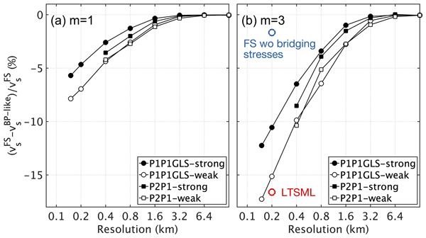
Martin Rückamp, Thomas Kleiner, and Angelika Humbert
The Cryosphere, 16, 1675–1696, https://doi.org/10.5194/tc-16-1675-2022, https://doi.org/10.5194/tc-16-1675-2022, 2022
Short summary
Short summary
We present a comparative modelling study between the full-Stokes (FS) and Blatter–Pattyn (BP) approximation applied to the Northeast Greenland Ice Stream. Both stress regimes are implemented in one single ice sheet code to eliminate numerical issues. The simulations unveil minor differences in the upper ice stream but become considerable at the grounding line of the 79° North Glacier. Model differences are stronger for a power-law friction than a linear friction law.
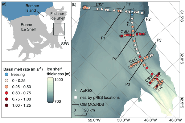
Ole Zeising, Daniel Steinhage, Keith W. Nicholls, Hugh F. J. Corr, Craig L. Stewart, and Angelika Humbert
The Cryosphere, 16, 1469–1482, https://doi.org/10.5194/tc-16-1469-2022, https://doi.org/10.5194/tc-16-1469-2022, 2022
Short summary
Short summary
Remote-sensing-derived basal melt rates of ice shelves are of great importance due to their capability to cover larger areas. We performed in situ measurements with a phase-sensitive radar on the southern Filchner Ice Shelf, showing moderate melt rates and low small-scale spatial variability. The comparison with remote-sensing-based melt rates revealed large differences caused by the estimation of vertical strain rates from remote sensing velocity fields that modern fields can overcome.
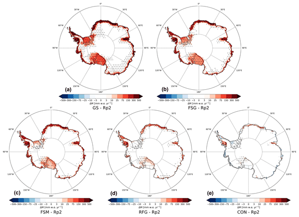
Christiaan T. van Dalum, Willem Jan van de Berg, and Michiel R. van den Broeke
The Cryosphere, 16, 1071–1089, https://doi.org/10.5194/tc-16-1071-2022, https://doi.org/10.5194/tc-16-1071-2022, 2022
Short summary
Short summary
In this study, we improve the regional climate model RACMO2 and investigate the climate of Antarctica. We have implemented a new radiative transfer and snow albedo scheme and do several sensitivity experiments. When fully tuned, the results compare well with observations and snow temperature profiles improve. Moreover, small changes in the albedo and the investigated processes can lead to a strong overestimation of melt, locally leading to runoff and a reduced surface mass balance.
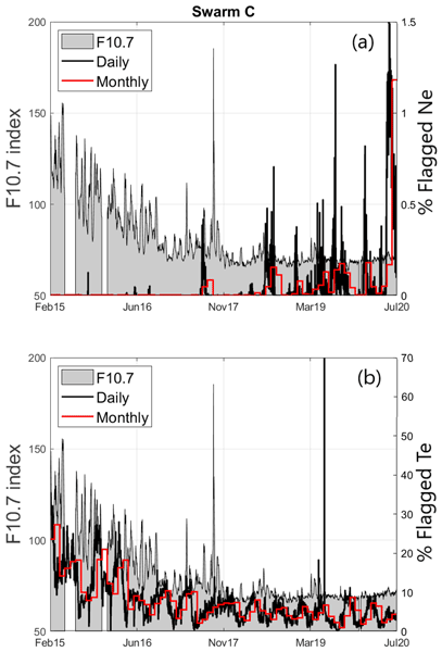
Filomena Catapano, Stephan Buchert, Enkelejda Qamili, Thomas Nilsson, Jerome Bouffard, Christian Siemes, Igino Coco, Raffaella D'Amicis, Lars Tøffner-Clausen, Lorenzo Trenchi, Poul Erik Holmdahl Olsen, and Anja Stromme
Geosci. Instrum. Method. Data Syst., 11, 149–162, https://doi.org/10.5194/gi-11-149-2022, https://doi.org/10.5194/gi-11-149-2022, 2022
Short summary
Short summary
The quality control and validation activities performed by the Swarm data quality team reveal the good-quality LPs. The analysis demonstrated that the current baseline plasma data products are improved with respect to previous baseline. The LPs have captured the ionospheric plasma variability over more than half of a solar cycle, revealing the data quality dependence on the solar activity. The quality of the LP data will further improve promotion of their application to a broad range of studies.
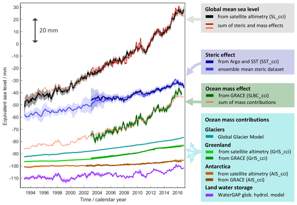
Martin Horwath, Benjamin D. Gutknecht, Anny Cazenave, Hindumathi Kulaiappan Palanisamy, Florence Marti, Ben Marzeion, Frank Paul, Raymond Le Bris, Anna E. Hogg, Inès Otosaka, Andrew Shepherd, Petra Döll, Denise Cáceres, Hannes Müller Schmied, Johnny A. Johannessen, Jan Even Øie Nilsen, Roshin P. Raj, René Forsberg, Louise Sandberg Sørensen, Valentina R. Barletta, Sebastian B. Simonsen, Per Knudsen, Ole Baltazar Andersen, Heidi Ranndal, Stine K. Rose, Christopher J. Merchant, Claire R. Macintosh, Karina von Schuckmann, Kristin Novotny, Andreas Groh, Marco Restano, and Jérôme Benveniste
Earth Syst. Sci. Data, 14, 411–447, https://doi.org/10.5194/essd-14-411-2022, https://doi.org/10.5194/essd-14-411-2022, 2022
Short summary
Short summary
Global mean sea-level change observed from 1993 to 2016 (mean rate of 3.05 mm yr−1) matches the combined effect of changes in water density (thermal expansion) and ocean mass. Ocean-mass change has been assessed through the contributions from glaciers, ice sheets, and land water storage or directly from satellite data since 2003. Our budget assessments of linear trends and monthly anomalies utilise new datasets and uncertainty characterisations developed within ESA's Climate Change Initiative.
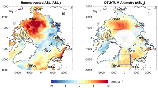
Carsten Bjerre Ludwigsen, Ole Baltazar Andersen, and Stine Kildegaard Rose
Ocean Sci., 18, 109–127, https://doi.org/10.5194/os-18-109-2022, https://doi.org/10.5194/os-18-109-2022, 2022
Short summary
Short summary
This study uses a novel satellite-independent approach to quantify the components of Arctic sea level change. The 21-year time series allows studying climate-related changes in Arctic sea level. The decomposition shows that fresh water is governing sea level change, while Arctic land ice loss contributes to a small Arctic sea level rise. The reconstruction yields good agreement with sea level observations from altimetry, despite both datasets being challenged by the harsh environment.

Timm Schultz, Ralf Müller, Dietmar Gross, and Angelika Humbert
The Cryosphere, 16, 143–158, https://doi.org/10.5194/tc-16-143-2022, https://doi.org/10.5194/tc-16-143-2022, 2022
Short summary
Short summary
Firn is the interstage product between snow and ice. Simulations describing the process of firn densification are used in the context of estimating mass changes of the ice sheets and past climate reconstructions. The first stage of firn densification takes place in the upper few meters of the firn column. We investigate how well a material law describing the process of grain boundary sliding works for the numerical simulation of firn densification in this stage.

Emma K. Fiedler, Matthew J. Martin, Ed Blockley, Davi Mignac, Nicolas Fournier, Andy Ridout, Andrew Shepherd, and Rachel Tilling
The Cryosphere, 16, 61–85, https://doi.org/10.5194/tc-16-61-2022, https://doi.org/10.5194/tc-16-61-2022, 2022
Short summary
Short summary
Sea ice thickness (SIT) observations derived from CryoSat-2 satellite measurements have been successfully used to initialise an ocean and sea ice forecasting model (FOAM). Other centres have previously used gridded and averaged SIT observations for this purpose, but we demonstrate here for the first time that SIT measurements along the satellite orbit track can be used. Validation of the resulting modelled SIT demonstrates improvements in the model performance compared to a control.
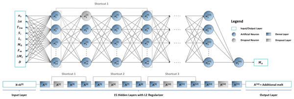
Zhongyang Hu, Peter Kuipers Munneke, Stef Lhermitte, Maaike Izeboud, and Michiel van den Broeke
The Cryosphere, 15, 5639–5658, https://doi.org/10.5194/tc-15-5639-2021, https://doi.org/10.5194/tc-15-5639-2021, 2021
Short summary
Short summary
Antarctica is shrinking, and part of the mass loss is caused by higher temperatures leading to more snowmelt. We use computer models to estimate the amount of melt, but this can be inaccurate – specifically in the areas with the most melt. This is because the model cannot account for small, darker areas like rocks or darker ice. Thus, we trained a computer using artificial intelligence and satellite images that showed these darker areas. The model computed an improved estimate of melt.
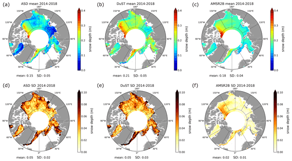
Florent Garnier, Sara Fleury, Gilles Garric, Jérôme Bouffard, Michel Tsamados, Antoine Laforge, Marion Bocquet, Renée Mie Fredensborg Hansen, and Frédérique Remy
The Cryosphere, 15, 5483–5512, https://doi.org/10.5194/tc-15-5483-2021, https://doi.org/10.5194/tc-15-5483-2021, 2021
Short summary
Short summary
Snow depth data are essential to monitor the impacts of climate change on sea ice volume variations and their impacts on the climate system. For that purpose, we present and assess the altimetric snow depth product, computed in both hemispheres from CryoSat-2 and SARAL satellite data. The use of these data instead of the common climatology reduces the sea ice thickness by about 30 cm over the 2013–2019 period. These data are also crucial to argue for the launch of the CRISTAL satellite mission.
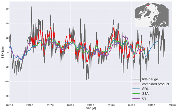
Pierre Prandi, Jean-Christophe Poisson, Yannice Faugère, Amandine Guillot, and Gérald Dibarboure
Earth Syst. Sci. Data, 13, 5469–5482, https://doi.org/10.5194/essd-13-5469-2021, https://doi.org/10.5194/essd-13-5469-2021, 2021
Short summary
Short summary
We investigate how mapping sea level in the Arctic Ocean can benefit from combining data from three satellite radar altimeters: CryoSat-2, Sentinel-3A and SARAL/AltiKa. A dedicated processing for SARAL/AltiKa provides a baseline for the cross-referencing of CryoSat-2 and Sentinel-3A before mapping. We show that by combining measurements coming from three missions, we are able to increase the resolution of gridded sea level fields in the ice-covered Arctic Ocean.
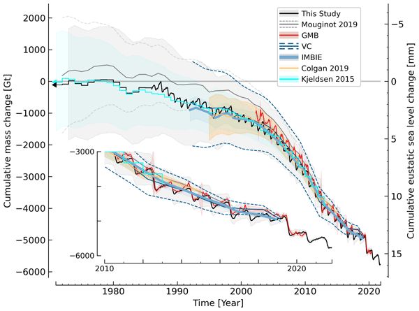
Kenneth D. Mankoff, Xavier Fettweis, Peter L. Langen, Martin Stendel, Kristian K. Kjeldsen, Nanna B. Karlsson, Brice Noël, Michiel R. van den Broeke, Anne Solgaard, William Colgan, Jason E. Box, Sebastian B. Simonsen, Michalea D. King, Andreas P. Ahlstrøm, Signe Bech Andersen, and Robert S. Fausto
Earth Syst. Sci. Data, 13, 5001–5025, https://doi.org/10.5194/essd-13-5001-2021, https://doi.org/10.5194/essd-13-5001-2021, 2021
Short summary
Short summary
We estimate the daily mass balance and its components (surface, marine, and basal mass balance) for the Greenland ice sheet. Our time series begins in 1840 and has annual resolution through 1985 and then daily from 1986 through next week. Results are operational (updated daily) and provided for the entire ice sheet or by commonly used regions or sectors. This is the first input–output mass balance estimate to include the basal mass balance.
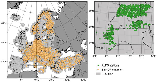
Zacharie Barrou Dumont, Simon Gascoin, Olivier Hagolle, Michaël Ablain, Rémi Jugier, Germain Salgues, Florence Marti, Aurore Dupuis, Marie Dumont, and Samuel Morin
The Cryosphere, 15, 4975–4980, https://doi.org/10.5194/tc-15-4975-2021, https://doi.org/10.5194/tc-15-4975-2021, 2021
Short summary
Short summary
Since 2020, the Copernicus High Resolution Snow & Ice Monitoring Service has distributed snow cover maps at 20 m resolution over Europe in near-real time. These products are derived from the Sentinel-2 Earth observation mission, with a revisit time of 5 d or less (cloud-permitting). Here we show the good accuracy of the snow detection over a wide range of regions in Europe, except in dense forest regions where the snow cover is hidden by the trees.
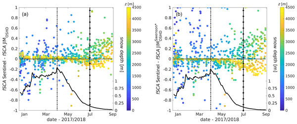
Nora Helbig, Michael Schirmer, Jan Magnusson, Flavia Mäder, Alec van Herwijnen, Louis Quéno, Yves Bühler, Jeff S. Deems, and Simon Gascoin
The Cryosphere, 15, 4607–4624, https://doi.org/10.5194/tc-15-4607-2021, https://doi.org/10.5194/tc-15-4607-2021, 2021
Short summary
Short summary
The snow cover spatial variability in mountains changes considerably over the course of a snow season. In applications such as weather, climate and hydrological predictions the fractional snow-covered area is therefore an essential parameter characterizing how much of the ground surface in a grid cell is currently covered by snow. We present a seasonal algorithm and a spatiotemporal evaluation suggesting that the algorithm can be applied in other geographic regions by any snow model application.
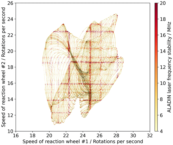
Oliver Lux, Christian Lemmerz, Fabian Weiler, Thomas Kanitz, Denny Wernham, Gonçalo Rodrigues, Andrew Hyslop, Olivier Lecrenier, Phil McGoldrick, Frédéric Fabre, Paolo Bravetti, Tommaso Parrinello, and Oliver Reitebuch
Atmos. Meas. Tech., 14, 6305–6333, https://doi.org/10.5194/amt-14-6305-2021, https://doi.org/10.5194/amt-14-6305-2021, 2021
Short summary
Short summary
The work assesses the frequency stability of the laser transmitters on board Aeolus and discusses its influence on the quality of the global wind data. Excellent frequency stability of the space lasers is evident, although enhanced frequency noise occurs at certain locations along the orbit due to micro-vibrations that are introduced by the satellite’s reaction wheels. The study elaborates on this finding and investigates the extent to which the enhanced frequency noise increases the wind error.
Cited articles
Armitage, T. W. K. and Davidson, M. W. J.: Using the Interferometric
Capabilities of the ESA CryoSat-2 Mission to Improve the Accuracy of Sea Ice
Freeboard Retrievals, IEEE T. Geosci. Remote,
52, 529–536, https://doi.org/10.1109/TGRS.2013.2242082, 2014.
Bartsch, A.: Ten Years of SeaWinds on QuikSCAT for Snow Applications, Remote
Sens., 2, 1142–1156, 2010.
Bartsch, A., Kumpula, T., Forbes, B. C., and Stammler, F.: Detection of snow
surface thawing and refreezing in the Eurasian Arctic with QuikSCAT:
implications for reindeer herding, Ecol. Appl., 20,
2346–2358, https://doi.org/10.1890/09-1927.1, 2010.
Blockley, E. W. and Peterson, K. A.: Improving Met Office seasonal predictions
of Arctic sea ice using assimilation of CryoSat-2 thickness, The Cryosphere, 12, 3419–3438, https://doi.org/10.5194/tc-12-3419-2018, 2018.
Bonnefond, P., Verron, J., Aublanc, J., Babu, K.N., Bergé-Nguyen, M.,
Cancet, M., Chaudhary, A., Crétaux, J.-F., Frappart, F., Haines, B. J.,
Laurain, O., Ollivier, A., Poisson, J.-C., Prandi, P., Sharma, R., Thibaut,
P., and Watson, C.: The Benefits of the Ka-Band as Evidenced from the
SARAL/AltiKa Altimetric Mission: Quality Assessment and Unique
Characteristics of AltiKa Data, Remote Sens., 10, 83, https://doi.org/10.3390/rs10010083, 2018.
Budyko, M. I.: The effect of solar radiation variations on the climate of the
Earth, Tellus, 21, 611–619, https://doi.org/10.3402/tellusa.v21i5.10109, 1969.
Chen, J. L., Wilson, C. R., and Tapley, B. D.: Contribution of ice sheet and
mountain glacier melt to recent sea level rise, Nat. Geosci., 6,
549–552, https://doi.org/10.1038/ngeo1829, 2013.
CMEMS-1: Copernicus Marine Environmental Monitoring System (CMEMS)
requirements for the Evolution of the Copernicus Satellite Component,
available at: http://marine.copernicus.eu/wp-content/uploads/2019/01/CMEMS-requirements-satellites.pdf (last access: 10 July 2020), 2017.
Connor, L. N., Farrell, S. L., McAdoo, D. C., Krabill, W. B., and Manizade S.:
Validating ICESat Over Thick Sea Ice in the Northern Canada Basin, IEEE
T. Geosci. Remote, 51, 2188–2200, https://doi.org/10.1109/TGRS.2012.2211603, 2013.
Copernicus Marine Environmental Monitoring Service (CMEMS):
http://marine.copernicus.eu, last access: 10 July 2020.
Copernicus Land Monitoring Service (CLMS):
http://land.copernicus.eu], last access: 10 July 2020.
Copernicus Atmospheric Monitoring Service (CAMS):
https://atmosphere.copernicus.eu, last access: 10 July 2020.
Copernicus Emergency Management Service (CEMS):
http://emergency.copernicus.eu, last access: 10 July 2020.
Copernicus Climate Change Service (C3S):
http://climate.copernicus.eu, last access: 10 July 2020.
DeConto, R. M. and Pollard, D.: Contribution of Antarctica to past and
future sea-level rise, Nature, 531, 591–597, 2016.
Drinkwater, M., Francis, R., Ratier, G., and Wingham, D.: The European Space
Agency's Earth Explorer Mission CryoSat: Measuring variability in the
cryosphere, Ann. Glaciol., 39, 313–320,
https://doi.org/10.3189/172756404781814663, 2004.
Duchossois G., Strobl, P., Toumazou ,V., Antunes, S., Bartsch, A., Diehl,
T., Dinessen, F., Eriksson, P., Garric, G., Houssais, M-N., Jindrova, M.,
Muñoz-Sabater J., Nagler T., and Nordbeck, O.: User Requirements for a
Copernicus Polar Mission – Phase 1 Report, EUR 29144 EN, Publications Office
of the European Union, Luxembourg, https://doi.org/10.2760/22832,
2018a.
Duchossois, G., Strobl P., Toumazou V., Antunes, S., Bartsch, A., Diehl, T.,
Dinessen, F., Eriksson, P., Garric, G., Holmlund, K., Houssais, M.-N.,
Jindrova, M., Kern, M., Muñoz-Sabater, J., Nagler, T., Nordbeck, O., and de
Witte, E.: User Requirements for a Copernicus Polar Mission – Phase 2 Report
EUR 29144 EN, Publications Office of the European Union, Luxembourg,
https://doi.org/10.2760/44170, 2018b.
Edwards, T. L., Brandon, M. A., Durand, G., Edwards, N. R., Golledge, N. R.,
Holden, P. B., Nias, I. J., Payne, A. J., Ritz, C., and Wernecke, A.:
Revisiting Antarctic ice loss due to marine ice-cliff
instability, Nature, 566, 58–64, https://doi.org/10.1038/s41586-019-0901-4, 2019.
Egido, A. and Smith, W. H. F.: Fully Focused SAR Altimetry: Theory and
Applications, IEEE T. Geosci. Remote, 55,
392–406, 2017.
ESA: Long-term Scenario, available at:
https://www.copernicus.eu/sites/default/files/2019-01/Copernicus_Work_Programme_2019.pdf (last access: 10 July 2020), 2019a.
ESA: Copernicus High Priority Candidates, Mission Requirements
Documents for the sixe candidate missions, available at:
https://www.esa.int/Applications/Observing_the_Earth/Copernicus/Copernicus_High_Priority_Candidates (last access: 10 July 2020), 2019b.
European Commission: Copernicus evolution, Guidance Document for Horizon
2020 Work Programme 2018–2020, Copernicus evolution, LC-SPACE-02-EO-2018,
LC-SPACE-03-EO-2018, available at:
https://ec.europa.eu/research/participants/data/ref/h2020/other/guides_for_applicants/h2020-supp-info-space-2-3-18-20_en.pdf (last access: 10 July 2020), 2017.
Flament, T. and Rémy, F.: Dynamic thinning of Antarctic glaciers from
along-track repeat radar altimetry, J. Glaciol., 58,
830–840, https://doi.org/10.3189/2012JoG11J118, 2012.
Foresta L., Gourmelen, N., Palsson, F., Nienow, P., Bjoernsson, H.,
and Shepherd, A.: Surface elevation change and mass balance of Icelandic ice
caps derived from swath mode CryoSat-2 altimetry, Geophys. Res.
Lett., 43, 12–138, https://doi.org/10.1002/2016GL071485, 2016.
Francis, J. A., Vavrus, S. J., and Cohen, J.: Amplified Arctic warming and
mid-latitude weather: new perspectives on emerging connections,
WIRES Clim. Change, 8, e474, https://doi.org/10.1002/wcc.474, 2017.
Gardner, A. S., Moholdt, G., Cogley J. G., Wouters, B., Arendt, A. A., Wahr,
J. A., Berthier, E., Hock, R., Pfeffer, W. T., Kaser, G., Ligtenberg, S. R. M.,
Bolch, M. J., Sharp, M. J., Hagen, J. O., van den Broeke, M. R., and Paul, F.: A
Reconciled Estimate of Glacier Contributions to Sea Level Rise: 2003 to
2009, Science, 340, 852–857, https://doi.org/10.1126/science.1234532. 2013.
GCOS: Systematic observation requirements for satellite-based products for
climate 2011 update: Supplemental details to the satellite-based component
of the “Implementation plan for the global observing system for climate in
support of the UNFCCC (2010 update), GCOS Rep. 154, available at:
https://library.wmo.int/index.php?lvl=notice_display&id=449#.XwhdGefLj-g (last access: 10 July 2020), 2011.
Giles, K. A., Laxon, S. W., Wingham, D. J., Wallis, D. W., Krabill, W. B.,
Leuschen, C. J., McAdoo, D., Manizade, S. S., and Raney, R. K.: Combined
airborne laser and radar altimeter measurements over the Fram Strait in May
2002, Remote Sens. Environ., 111, 182–194, 2007.
Giles, K. A., Laxon, S. W., and Ridout, A. L.: Circumpolar thinning of
Arctic sea ice following the 2007 record ice extent minimum, Geophys.
Res. Lett., 35, L22502, https://doi.org/10.1029/2008GL035710, 2008a.
Giles, K. A., Laxon, S. W., and Worby, A. P.: Antarctic sea ice elevation
from satellite radar altimetry, Geophys. Res. Lett., 35, L03503,
https://doi.org/10.1029/2007GL031572, 2008b.
Gourmelen, N., Escorihuela, M. J., Shepherd, A., Foresta, L., Muir, A.,
Garcia-Mondejar, A., Roca, M., Baker, S. G., and Drinkwater, M. R.: CryoSat-2
swath interferometric altimetry for mapping ice elevation and elevation
change, Adv. Space Res., 62, 1226–1242, https://doi.org/10.1016/j.asr.2017.11.014, 2017.
Guerreiro, K., Fleury, S., Zakharova, E., Rémy, F., and Kouraev, A.:
Potential for estimation of snow depth on Arctic sea ice from CryoSat-2 and
SARAL/AltiKa missions, Remote Sens. Environ., 186, 339–349,
https://doi.org/10.1016/j.rse.2016.07.013, 2016.
Hendricks, S., Ricker, R., and Helm, V.: User Guide – AWI CryoSat-2 Sea Ice
Thickness Data Product (v1.2), AWI, hdl:10013/epic.48201.d001, 2016.
Hurkmans, R. T. W. L., Bamber, J. L., Davis, C. H., Joughin, I. R., Khvorostovsky, K. S., Smith, B. S., and Schoen, N.: Time-evolving mass loss of the Greenland Ice Sheet from satellite altimetry, The Cryosphere, 8, 1725–1740, https://doi.org/10.5194/tc-8-1725-2014, 2014.
IPCC: IPCC Summary for Policymakers, in: IPCC Special Report on the Ocean and
Cryosphere in a Changing Climate, edited by: Pörtner, H.-O., Roberts, D. C.,
Masson-Delmotte, V., Zhai, P., Tignor, M., Poloczanska, E., Mintenbeck, K., Nicolai, M., Okem, A., Petzold, J., Rama, B., and Weyer, N., available at: https://www.ipcc.ch/site/assets/uploads/sites/3/2019/11/03_SROCC_SPM_FINAL.pdf (last access: 10 July 2020), 2019.
Jiang, L., Schneider, R., Andersen, O. B., and Bauer-Gottwein, P.: CryoSat-2
Altimetry Applications over Rivers and Lakes, Water, 9, 211,
https://doi.org/10.3390/w9030211, 2017.
Konrad, H., Gilbert, L., Cornford, S. L., Payne, A., Hogg, A., Muir, A., and
Shepherd, A: Uneven onset and pace of ice-dynamical imbalance in the
Amundsen Sea Embayment, West Antarctica, Geophys. Res. Lett.,
44, 910–918, https://doi.org/10.1002/2016GL070733, 2017.
Kroisleitner, C., Bartsch, A., and Bergstedt, H.: Circumpolar patterns of potential mean annual ground temperature based on surface state obtained from microwave satellite data, The Cryosphere, 12, 2349–2370, https://doi.org/10.5194/tc-12-2349-2018, 2018.
Kurtz, N. T., Galin, N., and Studinger, M.: An improved CryoSat-2 sea ice freeboard retrieval algorithm through the use of waveform fitting, The Cryosphere, 8, 1217–1237, https://doi.org/10.5194/tc-8-1217-2014, 2014.
Lawrence, I. R., Tsamados, M. C., Stroeve, J. C., Armitage, T. W. K., and Ridout, A. L.: Estimating snow depth over Arctic sea ice from calibrated dual-frequency radar freeboards, The Cryosphere, 12, 3551–3564, https://doi.org/10.5194/tc-12-3551-2018, 2018.
Laxon, S. W., Peacock, N., and Smith, D.: High interannual variability of sea ice
thickness in the Arctic region, Nature, 425, 947–950, 2003.
Laxon S. W., Giles, K. A., Ridout, A. L., Wingham, D. J., Willatt, R.,
Cullen, R., Kwok, R., Schweiger, A., Zhang, J., Haas, C., Hendricks, S.,
Krishfield, R., Kurtz, N., Farrell, S., and Davidson, M.: CryoSat-2
estimates of Arctic sea ice thickness and volume, Geophys. Res.
Lett., 40, 732–737, https://doi.org/10.1002/grl.50193,
2013.
Legeais, J.-F., Ablain, M., and Thao, S.: Evaluation of wet troposphere path delays from atmospheric reanalyses and radiometers and their impact on the altimeter sea level, Ocean Sci., 10, 893–905, https://doi.org/10.5194/os-10-893-2014, 2014.
Lemmetyinen, J., Kontu, A., Pulliainen, J., Vehviläinen, J., Rautiainen, K., Wiesmann, A., Mätzler, C., Werner, C., Rott, H., Nagler, T., Schneebeli, M., Proksch, M., Schüttemeyer, D., Kern, M., and Davidson, M. W. J.: Nordic Snow Radar Experiment, Geosci. Instrum. Method. Data Syst., 5, 403–415, https://doi.org/10.5194/gi-5-403-2016, 2016.
Mallett, R. D. C., Lawrence, I. R., Stroeve, J. C., Landy, J. C., and Tsamados, M.: Brief communication: Conventional assumptions involving the speed of radar waves in snow introduce systematic underestimates to sea ice thickness and seasonal growth rate estimates, The Cryosphere, 14, 251–260, https://doi.org/10.5194/tc-14-251-2020, 2020.
McMillan, M., Shepherd, A., Sundal, A., Briggs, K., Muir, A., Ridout, A.,
Hogg, A., and Wingham, D.: Increased ice losses from Antarctica detected by
CryoSat-2, Geophys. Res. Lett., 41, 3899–3905, https://doi.org/10.1002/2014GL060111, 2014.
McMillan, M., Leeson, A., Shepherd, A., Briggs, K., Armitage, T. W. K. T. W.
K., Hogg, A., Munneke, P. K., van den Broeke, M., Noel, B., van den Berg, W.
J., Ligtenberg, S., Horwarth, M., Groh, A. Muir, A., and Gilbert, L.: A
high-resolution record of Greenland mass balance, Geophys. Res.
Lett., 43, 7002–7010, https://doi.org/10.1002/2016GL069666, 2016.
Meredith, M., Sommerkorn, M., Cassotta, S., Derksen, C., Ekaykin, A.,
Hollowed, A., Kofinas, G., Mackintosh, A., Melbourne-Thomas, J., Muelbert, M. M. C.,
Ottersen, G., Pritchard, H., and Schuur, E. A. G.: Polar regions, in: IPCC
Special Report on the Ocean and Cryosphere in a Changing Climate, edited by: Pörtner, H.-O., Roberts, D. C., Masson-Delmotte, V., Zhai, P., Tignor, M.,
Poloczanska, E., Mintenbeck, K., Alegría, A., Nicolai, M., Okem, A.,
Petzold, J., Rama, B., and Weyer, N. M., IPCC, 2019.
Nandan, V., Geldsetzer, T., Yackel, J., Mahmud, M., Scharien, R., Howell,
S., King, J., Ricker, R., and Else, B.: Effect of snow salinity on CryoSat-2
Arctic first-year sea ice freeboard measurements, Geophys. Res.
Lett., 44, 10419–10426, https://doi.org/10.1002/2017GL074506,
2017.
Nandan, V., Scharien, R. K., Geldsetzer, T., Kwok, R., Yackel, J. J., Mahmud,
M. S., Roesel, A., Tonboe, R., Granskog, M., Willatt, R., Stroeve, J.,
Nomura, D., and Frey, M.: Snow Property Controls on Modelled Ku-band Altimeter
Estimates of First-Year Sea Ice Thickness: Case studies from the Canadian
and Norwegian Arctic, IEEE J. Sel. Top Appl., 13, 1082–1096,
https://doi.org/10.1109/jstars.2020.2966432, 2020.
Park, S.-E., Bartsch, A., Sabel, D., Wagner, W., Naeimi, V.,
and Yamaguchi, Y. : Monitoring freeze/thaw cycles using ENVISAT ASAR global
mode, Remote Sens. Environ., 115 , 3457–3467,
https://doi.org/10.1016/j.rse.2011.08.009, 2011.
Parrinello, T., Shepherd, A., Bouffard, J., Badessi, S., Casal, T.,
Davidson, M., Fornari, M., Maestroni, E., and Scagliola, M.: CryoSat: ESA's ice mission – Eight years in space,
Adv. Space Res., 62, 1178–1190, https://doi.org/10.1016/j.asr.2018.04.014, 2018.
Perovich, D., Meier, W., Tschudi, M., Farrell, S., Gerland, S., Hendricks, S.,
Krumpen, T., and Haas, C.: Sea ice cover: in “State of the Climate in 2016”,
B. Am. Meteorol. Soc., 98, S131–S133, 2017.
Picard, B., Frery, M. L., Obligis, E., Eymard, L., Steunou, N., and Picot,
N.: SARAL/AltiKa Wet Tropospheric Correction: In-Flight Calibration,
Retrieval Strategies and Performances, Marine Geodesy, 38,
277–296, https://doi.org/10.1080/01490419.2015.1040903, 2015.
Price, D., Beckers, J., Ricker, R., Kurtz, N., Rack, W., Haas, C., Helm, V.,
Hendricks, S. Leonard, G., and Langhorne, P. J.: Evaluation of CryoSat-2
derived sea-ice freeboard over fast ice in McMurdo Sound, Antarctica,
J. Glaciol., 61, 285–300, https://doi.org/10.3189/2015JoG14J157, 2015.
Prowse, T., Alfredsen, K., Beltaos, S., Bonsal, B., Duguay, C., Korhola, A.,
McNamara, J., Pienitz, R., Vincent, W. F., Vuglinsky, V., and Weyhenmeyer, G. A:
Past and Future Changes in Arctic Lake and River Ice, Ambio, 40,
53–62, https://doi.org/10.1007/s13280-011-0216-7, 2011.
Quartly, G. D., Rinne, E., Passaro, M., Andersen, O. A., Dinardo, S., Fleury
S., Guillot, A., Hendricks, S., Kurekin, A. A., Müller, F. L., Ricker,
R. , Skourup, H., and Tsamados, M.: Retrieving Sea Level and Freeboard in the
Arctic: A Review of Current Radar Altimetry Methodologies and Future
Perspectives, Remote Sens., 11, 881, https://doi.org/10.3390/rs11070881, 2019.
Raney, R. K.: The Delay/Doppler Radar Altimeter, IEEE T. Geosci.
Remote, 36, 1578–1588, 1998.
Ricker, R., Hendricks, S., Helm, V., Skourup, H., and Davidson, M.: Sensitivity of CryoSat-2 Arctic sea-ice freeboard and thickness on radar-waveform interpretation, The Cryosphere, 8, 1607–1622, https://doi.org/10.5194/tc-8-1607-2014, 2014.
Rott, H., Shi, J., Xiong, C., and Cui, Y.: Snow properties from active remote
sensing instruments, in: Comprehensive Remote Sensing, edited by: Liang, S., vol. 4, 237–257, https://doi.org/10.1016/B978-0-12-409548-9.10359-8, 2018.
Sallila, H., Farrell, S. L., McCurry, J., and Rinne, E.: Assessment of contemporary satellite sea ice thickness products for Arctic sea ice, The Cryosphere, 13, 1187–1213, https://doi.org/10.5194/tc-13-1187-2019, 2019.
Screen, J. A. and Simmonds, I.: The central role of diminishing sea ice in
recent Arctic temperature amplification, Nature, 464, 1334–1337,
https://doi.org/10.1038/nature09051, 2010.
Serreze, M. C. and Francis, J. A.: The Arctic Amplification Debate, Clim.
Change, 76, 241–264, https://doi.org/10.1007/s10584-005-9017-y, 2006.
Siegert, M. J., Ross, N., and Le Brocq, A. M.: Recent advances in
understanding Antarctic subglacial lakes and hydrology, Philos. T. R. Soc. A, 374, 2059, https://doi.org/10.1098/rsta.2014.0306, 2016.
Shepherd, A., Ivins, E. R., Geruo, A., Barletta, V. R., Bentley, M. J.,
Bettadpur, S., Briggs, K. H., Bromwich, D. H., Forsberg, R., Galin, N.,
Horwath, M., Jacobs, S., Joughin, I., King, M. A., Lenaerts, J. T. M., Li,
J., Ligtenberg, S. R. M., Luckman, A., Luthcke, S. B., McMillan, M.,
Meister, R., Milne, G., Mouginot, J., Muir, A., Nicolas, J. P., Paden, J.,
Payne, A. J., Pritchard, H., Rignot, E., Rott, H., Sandberg Sørensen, L.,
Scambos, T.A., Scheuchl, B., Schrama, E. J. O., Smith B., Sundal, A. V., van
Angelen, J. H., van de Berg, W. J., van den Broeke, M. R., Vaughan, D. G.,
Velicogna, I., Wahr, J., Whitehouse, P. L., Wingham, D. J., Yi, D., Young,
D., and Zwally, H. J.: A reconciled estimate of ice-sheet mass balance, Science,
338, 6111, https://doi.org/10.1126/science.1228102, 2012.
Shepherd, A., Fricker, H. A., and Farrell, S. L.: Trends and connections
across the Antarctic cryosphere, Nature, 558, 223–232, https://doi.org/10.1038/s41586-018-0171-6, 2018.
Shepherd, A., Ivins, E., Rignot, E., et al.: Mass balance of the Greenland
Ice Sheet from 1992 to 2018, Nature, 579, 233–239, https://doi.org/10.1038/s41586-019-1855-2, 2020.
Shiklomanov, A. I., Lammers, R. B., Rawlins, M. A., Smith, L. C., and
Pavelsky, T. M.: Temporal and spatial variations in maximum river discharge
from a new Russian data set, J. Geophys. Res.-Biogeo., 112, G04S53, https://doi.org/10.1029/2006JG000352, 2007.
Sørensen, L. S., Simonsen, S. B., Meister, R., Forsberg, R., Levinsen, J.
F., and Flament, T.: Envisat-derived elevation changes of the Greenland ice
sheet, and a comparison with ICESat results in the accumulation area, Remote
Sens. Environ., 160, 56–62, https://doi.org/10.1016/j.rse.2014.12.022, 2015.
Smith, B., Fricker, H. A., Gardner, A. S., Medley, B., Nilsson, J., Paolo,
F. S., Holschuh, N., Adusumilli, S., Brunt, K., Csatho, B., Harbeck, K.,
Markus, T., Neumann, T., Siegfried, M. R., and Zwally, H. J.: Pervasive ice sheet
mass loss reflects competing ocean and atmosphere processes, Science, 368, 1239–1242, https://doi.org/10.1126/science.aaz5845, 2020.
Tilling, R. L., Ridout, A., and Shepherd, A.: Estimating Arctic sea ice
thickness and volume using CryoSat-2 radar altimeter data, Adv. Space
Res., 62, 1203–1225, https://doi.org/10.1016/j.asr.2017.10.051, 2018.
Tournadre, J., Bouhier, N., Girard-Ardhuin, F., and Rémy, F.: Large
icebergs characteristics from altimeter waveforms analysis, J.
Geophys. Res.-Oceans, 120, 1954–1974,
https://doi.org/10.1002/2014JC010502, 2015.
Tournadre, J., Bouhier, N., Girard-Ardhuin, F., and Remy, F.: Antarctic
icebergs distributions 1992–2014, J. Geophys. Res.-Oceans,
121, 327–349, 2016.
Tournadre, J., Bouhier, N., Boy, F., and Dinardo, S.: Detection of iceberg
using Delay Doppler and interferometric Cryosat-2 altimeter data., Remote
Sens. Environ., 212, 134–147, https://doi.org/10.1016/j.rse.2018.04.037, 2018.
Tran, N., Girard-Ardhuin, F., Ezraty, R., Feng, H., and Femenias, P.: Defining a
Sea Ice Flag for Envisat Altimetry Mission, IEEE Geosci. Remote
S., 6, 77–81, 2009.
Tynan, C. T., Ainley, D. G., and Stirling, I.: Sea ice: a critical habitat for
polar marine mammals and birds, chap. 11, in: Sea Ice, 2nd edn.,
edited by: Thomas. D. N. and Dieckmann, G. S., Wiley, https://doi.org/10.1002/9781444317145.ch11, 2009.
United Nations Framework Convention on Climate Change: 21st Conference of
the Parties,Conference of Parties, Paris, France, 7–8 December 2015, available at: http://www.cop21paris.org/ (last access: 10 July 2020), 2014.
Vieira, T., Fernandes, M. J., and Lázaro, S.: Impact of the New ERA5
Reanalysis in the Computation of Radar Altimeter Wet Path Delays, IEEE
T. Geosci. Remote, 57, 9849–9857, https://doi.org/10.1109/TGRS.2019.2929737, 2019.
Warren, S. G., Rigor, I. G., Untersteiner, N., Radionov, V. F., Bryazgin, N.
N., Aleksandrov, Y. I., and Colony, R.: Snow depth on Arctic sea ice,
J. Climate, 12, 1814–1829, 1999.
Whiteman, G., Hope C., and Wadhams, P.: Climate science: Vast costs of
Arctic change, Nature, 499, 401–403, 2013.
Wingham, D., Wallis, D., and Shepherd, A.: Spatial and temporal evolution of
Pine Island Glacier thinning, 1995–2006, Geophys. Res. Lett.,
36, L17501, https://doi.org/10.1029/2009gl039126, 2009.
Wingham, D. J., Francis, C. R., Baker, S., Bouzinac, C., Brockley, D.,
Cullen, R., de Chateau-Thierry, P., Laxon, S. W., Mallow, U., Mavrocordatos,
C., Phalippou, L., Ratier, G., Rey, L., Rostan, F., Viau, P., and Wallis, D. W.:
CryoSat: A mission to determine the fluctuations in Earth's land and marine
ice fields, Adv. Space Res., 37, 841–871, https://doi.org/10.1016/j.asr.2005.07.027, 2006
Wouters, B., Gardner, A. S., and Moholdt, G.: Global glacier mass loss
during the GRACE satellite mission (2002–2016), Front. Earth Sci.,
7, 96, https://doi.org/10.3389/feart.2019.00096, 2019.
Zakharova, E. A., Kouraev, A. V., Stephane, G., Franck, G., Desyatkin, R. V., and
Desyatkin, A. R.: Recent dynamics of hydro-ecosystems in thermokarst
depressions in Central Siberia from satellite and in situ observations:
Importance for agriculture and human life, Sci. Total Environ.,
615, 1290–1304, https://doi.org/10.1016/j.scitotenv.2017.09.059, 2018.
Zakharova, E. A., Nielsen, K., Kamenev, G., and Kouraev, A.: River discharge
estimation from radar altimetry: Assessment of satellite performance, river
scales and methods, J. Hydrol., 583, 124561, https://doi.org/10.1016/j.jhydrol.2020.124561, 2020.
Zhou, L., Stroeve, J., Xu, S., Petty, A., Tilling, R., Winstrup, M., Rostosky, P., Lawrence, I. R., Liston, G. E., Ridout, A., Tsamados, M., and Nandan, V.: Inter-comparison of snow depth over sea ice from multiple methods, The Cryosphere Discuss., https://doi.org/10.5194/tc-2020-65, in review, 2020.
Short summary
The Copernicus Polar Ice and Snow Topography Altimeter will provide high-resolution sea ice thickness and land ice elevation measurements and the capability to determine the properties of snow cover on ice to serve operational products and services of direct relevance to the polar regions. This paper describes the mission objectives, identifies the key contributions the CRISTAL mission will make, and presents a concept – as far as it is already defined – for the mission payload.
The Copernicus Polar Ice and Snow Topography Altimeter will provide high-resolution sea ice...


