
Articles | Volume 11, issue 6
https://doi.org/10.5194/tc-11-2411-2017
© Author(s) 2017. This work is distributed under
the Creative Commons Attribution 3.0 License.
the Creative Commons Attribution 3.0 License.
https://doi.org/10.5194/tc-11-2411-2017
© Author(s) 2017. This work is distributed under
the Creative Commons Attribution 3.0 License.
the Creative Commons Attribution 3.0 License.
Research article
| 
01 Nov 2017
Research article |
| 01 Nov 2017
Observationally constrained surface mass balance of Larsen C ice shelf, Antarctica
Peter Kuipers Munneke
CORRESPONDING AUTHOR
Institute for Marine and Atmospheric research, Utrecht University, Utrecht, the Netherlands
Daniel McGrath
Geosciences Department, Colorado State University, Fort Collins, CO, USA
U.S. Geological Survey, Alaska Science Center, Anchorage, AK, USA
Brooke Medley
Cryospheric Sciences Laboratory, NASA Goddard Space Flight Center, Greenbelt, MD, USA
Adrian Luckman
Geography Department, College of Science, Swansea University, Swansea, UK
Suzanne Bevan
Geography Department, College of Science, Swansea University, Swansea, UK
Bernd Kulessa
Geography Department, College of Science, Swansea University, Swansea, UK
Daniela Jansen
Alfred Wegener Institute Helmholtz-Centre for Polar and Marine Research, Bremerhaven, Germany
Adam Booth
School of Earth and Environment, University of Leeds, Leeds, UK
Paul Smeets
Institute for Marine and Atmospheric research, Utrecht University, Utrecht, the Netherlands
Bryn Hubbard
Centre for Glaciology, Department of Geography and Earth Sciences, Aberystwyth University, Aberystwyth, UK
David Ashmore
Centre for Glaciology, Department of Geography and Earth Sciences, Aberystwyth University, Aberystwyth, UK
Michiel Van den Broeke
Institute for Marine and Atmospheric research, Utrecht University, Utrecht, the Netherlands
Heidi Sevestre
Department of Geography and Sustainable Development, University of St Andrews, St Andrews, UK
Konrad Steffen
Swiss Federal Research Institute WSL, Birmensdorf, Switzerland
Andrew Shepherd
School of Earth and Environment, University of Leeds, Leeds, UK
Noel Gourmelen
School of Geosciences, University of Edinburgh, Edinburgh, UK
Related authors
Sanne B. M. Veldhuijsen, Peter Kuipers Munneke, Willem Jan van de Berg, Michiel R. van den Broeke, and Luke D. Trusel
EGUsphere, https://doi.org/10.5194/egusphere-2026-3453, https://doi.org/10.5194/egusphere-2026-3453, 2026
This preprint is open for discussion and under review for The Cryosphere (TC).
Short summary
Short summary
Antarctica has floating ice shelves around its perimeter that provide stability to the ice sheet. As temperature rises, snow on the ice shelves may melt away, and ponding of meltwater may cause the ice shelves to collapse. If that happens, Antarctica may start to lose ice faster than before, resulting in accelerated sea-level rise. The tool presented in this article will be used in simulations of future climate to determine when climate change leads to collapse of the ice shelves in Antarctica.
Maud Bernat, Etienne Berthier, Amaury Dehecq, Romain Hugonnet, Joaquin M. C. Belart, Naomi Ochwat, Peter Kuipers Munneke, Elizabeth Case, Ted Scambos, Louis-Marie Gauer, and David Youssefi
The Cryosphere, 20, 3025–3049, https://doi.org/10.5194/tc-20-3025-2026, https://doi.org/10.5194/tc-20-3025-2026, 2026
Short summary
Short summary
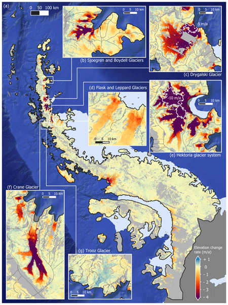
The Antarctic Peninsula is a mountainous region containing an ice sheet and peripheral glaciers. Differences remain between the methods used to estimate its mass changes. We use thousands of digital elevation models derived from high resolution stereoscopic images to calculate a new estimate of mass changes. We find that between 2007 and 2021, the ice sheet lost -28±6Gt/a and its peripheral glaciers -14±3Gt/a. We highlight the importance of resolving fine-scale changes in complex coastal areas.
Tesse E. A. van den Aker, Peter Kuipers Munneke, Willem Jan van de Berg, Walter W. Immerzeel, and Michiel R. van den Broeke
EGUsphere, https://doi.org/10.5194/egusphere-2026-462, https://doi.org/10.5194/egusphere-2026-462, 2026
Short summary
Short summary
The firn layer, i.e. permanent snow, regulates how an ice sheet responds to climate change. Firn models are forced with with climate data at time steps from sub-daily to annual in literature, however, implications are barely evaluated. We test the impact of different climate forcing time steps on the modeled firn layer. We conclude that the climate forcing time step (1) affects firn model output, (2) can lead to non-physical behaviour, and (3) that resolving at least a diurnal cycle is required.

Horst Machguth, Andrew Tedstone, Peter Kuipers Munneke, Max Brils, Brice Noël, Nicole Clerx, Nicolas Jullien, Xavier Fettweis, and Michiel van den Broeke
The Cryosphere, 20, 427–452, https://doi.org/10.5194/tc-20-427-2026, https://doi.org/10.5194/tc-20-427-2026, 2026
Short summary
Short summary
Due to increasing air temperatures, surface melt expands to higher elevations on the Greenland ice sheet. This is visible on satellite imagery in the form of rivers of meltwater running across the surface of the ice sheet. We compare model results of meltwater at high elevations on the ice sheet to satellite observations. We find that each of the models shows strengths and weaknesses. A detailed look into the model results reveals potential reasons for the differences between models.
Valeria Di Biase, Peter Kuipers Munneke, Bert Wouters, Michiel R. van den Broeke, and Maurice van Tiggelen
The Cryosphere, 20, 87–96, https://doi.org/10.5194/tc-20-87-2026, https://doi.org/10.5194/tc-20-87-2026, 2026
Short summary
Short summary
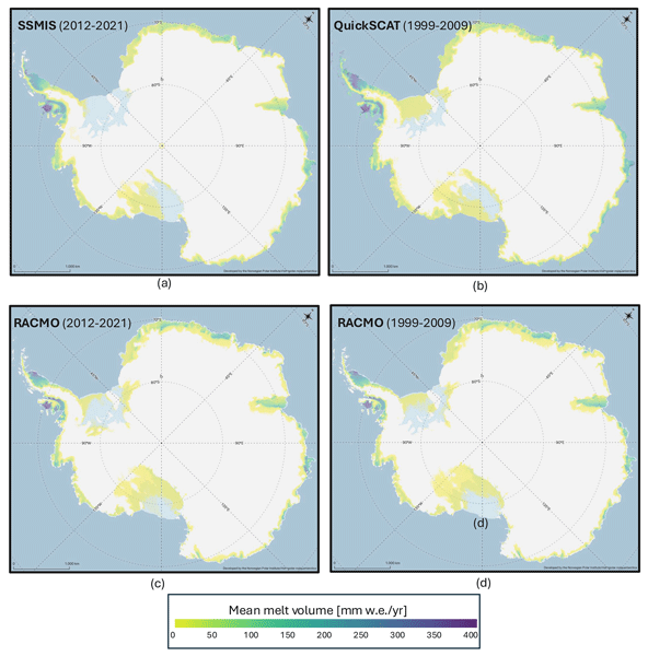
We produce annual maps of Antarctic surface melt volumes from 2012 to 2021 using satellite microwave data. We detect melting days from thresholds on the satellite signal and then use actual melt measurements from weather stations to convert those signals into water‑equivalent volumes. Our maps capture known melt hotspots and show slightly lower totals than climate models. This dataset supports climate and ice‑shelf studies.
Sanne B. M. Veldhuijsen, Willem Jan van de Berg, Peter Kuipers Munneke, Nicolaj Hansen, Fredrik Boberg, Christoph Kittel, Charles Amory, and Michiel R. van den Broeke
The Cryosphere, 19, 5157–5173, https://doi.org/10.5194/tc-19-5157-2025, https://doi.org/10.5194/tc-19-5157-2025, 2025
Short summary
Short summary
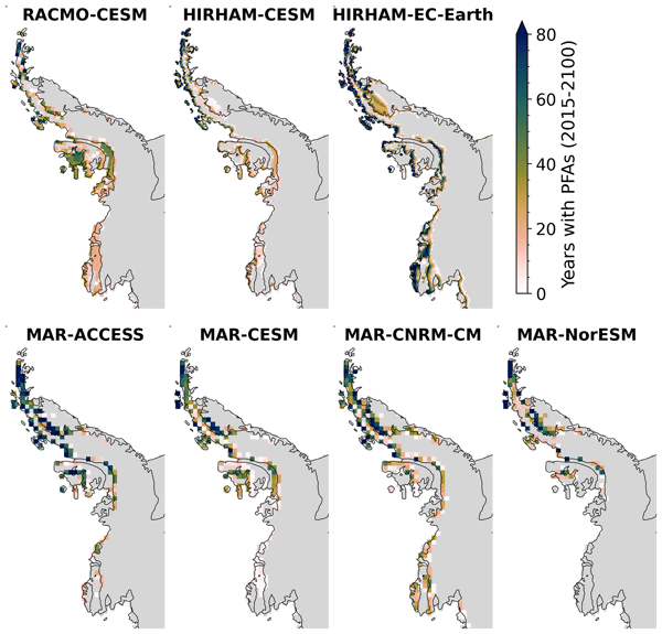
Perennial firn aquifers (PFAs), year-round bodies of liquid water within firns, can potentially impact ice-shelf and ice-sheet stability. We developed a fast XGBoost firn emulator to predict the 21st-century distribution of PFAs in Antarctica for 12 climatic forcing datasets. Our findings suggest that, in low-emission scenarios, PFAs remain confined to the Antarctic Peninsula. However, in a high-emission scenario, PFAs are projected to expand to a region in West Antarctica and East Antarctica.
Maurice van Tiggelen, Paul C. J. P. Smeets, Carleen H. Reijmer, Peter Kuipers Munneke, and Michiel R. van den Broeke
Earth Syst. Sci. Data, 17, 4933–4955, https://doi.org/10.5194/essd-17-4933-2025, https://doi.org/10.5194/essd-17-4933-2025, 2025
Short summary
Short summary
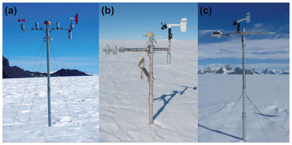
This paper describes the measurements from the 19 IMAU (Institute for Marine and Atmospheric research Utrecht) automatic weather stations that operated on the Antarctic ice sheet from 1995 through 2022. These stations also measured the net surface radiation and surface height change, allowing for the quantification of the surface energy and mass balance at hourly resolution. These data are invaluable for the evaluation of atmospheric models and for the detection of climatological changes.
Maria T. Kappelsberger, Martin Horwath, Eric Buchta, Matthias O. Willen, Ludwig Schröder, Sanne B. M. Veldhuijsen, Peter Kuipers Munneke, and Michiel R. van den Broeke
The Cryosphere, 18, 4355–4378, https://doi.org/10.5194/tc-18-4355-2024, https://doi.org/10.5194/tc-18-4355-2024, 2024
Short summary
Short summary
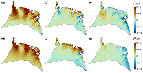
The interannual variations in the height of the Antarctic Ice Sheet (AIS) are mainly due to natural variations in snowfall. Precise knowledge of these variations is important for the detection of any long-term climatic trends in AIS surface elevation. We present a new product that spatially resolves these height variations over the period 1992–2017. The product combines the strengths of atmospheric modeling results and satellite altimetry measurements.
Sanne B. M. Veldhuijsen, Willem Jan van de Berg, Peter Kuipers Munneke, and Michiel R. van den Broeke
The Cryosphere, 18, 1983–1999, https://doi.org/10.5194/tc-18-1983-2024, https://doi.org/10.5194/tc-18-1983-2024, 2024
Short summary
Short summary
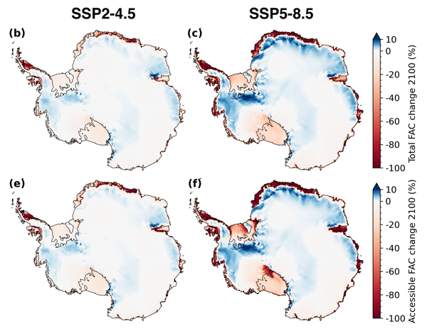
We use the IMAU firn densification model to simulate the 21st-century evolution of Antarctic firn air content. Ice shelves on the Antarctic Peninsula and the Roi Baudouin Ice Shelf in Dronning Maud Land are particularly vulnerable to total firn air content (FAC) depletion. Our results also underline the potentially large vulnerability of low-accumulation ice shelves to firn air depletion through ice slab formation.
Baptiste Vandecrux, Robert S. Fausto, Jason E. Box, Federico Covi, Regine Hock, Åsa K. Rennermalm, Achim Heilig, Jakob Abermann, Dirk van As, Elisa Bjerre, Xavier Fettweis, Paul C. J. P. Smeets, Peter Kuipers Munneke, Michiel R. van den Broeke, Max Brils, Peter L. Langen, Ruth Mottram, and Andreas P. Ahlstrøm
The Cryosphere, 18, 609–631, https://doi.org/10.5194/tc-18-609-2024, https://doi.org/10.5194/tc-18-609-2024, 2024
Short summary
Short summary
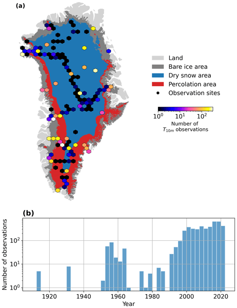
How fast is the Greenland ice sheet warming? In this study, we compiled 4500+ temperature measurements at 10 m below the ice sheet surface (T10m) from 1912 to 2022. We trained a machine learning model on these data and reconstructed T10m for the ice sheet during 1950–2022. After a slight cooling during 1950–1985, the ice sheet warmed at a rate of 0.7 °C per decade until 2022. Climate models showed mixed results compared to our observations and underestimated the warming in key regions.
Lena G. Buth, Valeria Di Biase, Peter Kuipers Munneke, Stef Lhermitte, Sanne B. M. Veldhuijsen, Sophie de Roda Husman, Michiel R. van den Broeke, and Bert Wouters
EGUsphere, https://doi.org/10.5194/egusphere-2023-2000, https://doi.org/10.5194/egusphere-2023-2000, 2023
Preprint archived
Short summary
Short summary
Liquid meltwater which is stored in air bubbles in the compacted snow near the surface of Antarctica can affect ice shelf stability. In order to detect the presence of such firn aquifers over large scales, satellite remote sensing is needed. In this paper, we present our new detection method using radar satellite data as well as the results for the whole Antarctic Peninsula. Firn aquifers are found in the north and northwest of the peninsula, in agreement with locations predicted by models.

Sanne B. M. Veldhuijsen, Willem Jan van de Berg, Max Brils, Peter Kuipers Munneke, and Michiel R. van den Broeke
The Cryosphere, 17, 1675–1696, https://doi.org/10.5194/tc-17-1675-2023, https://doi.org/10.5194/tc-17-1675-2023, 2023
Short summary
Short summary
Firn is the transition of snow to glacier ice and covers 99 % of the Antarctic ice sheet. Knowledge about the firn layer and its variability is important, as it impacts satellite-based estimates of ice sheet mass change. Also, firn contains pores in which nearly all of the surface melt is retained. Here, we improve a semi-empirical firn model and simulate the firn characteristics for the period 1979–2020. We evaluate the performance with field and satellite measures and test its sensitivity.
Lena G. Buth, Bert Wouters, Sanne B. M. Veldhuijsen, Stef Lhermitte, Peter Kuipers Munneke, and Michiel R. van den Broeke
The Cryosphere Discuss., https://doi.org/10.5194/tc-2022-127, https://doi.org/10.5194/tc-2022-127, 2022
Manuscript not accepted for further review
Short summary
Short summary
Liquid meltwater which is stored in air bubbles in the compacted snow near the surface of Antarctica can affect ice shelf stability. In order to detect the presence of such firn aquifers over large scales, satellite remote sensing is needed. In this paper, we present our new detection method using radar satellite data as well as the results for the whole Antarctic Peninsula. Firn aquifers are found in the north and northwest of the peninsula, in agreement with locations predicted by models.
Max Brils, Peter Kuipers Munneke, Willem Jan van de Berg, and Michiel van den Broeke
Geosci. Model Dev., 15, 7121–7138, https://doi.org/10.5194/gmd-15-7121-2022, https://doi.org/10.5194/gmd-15-7121-2022, 2022
Short summary
Short summary
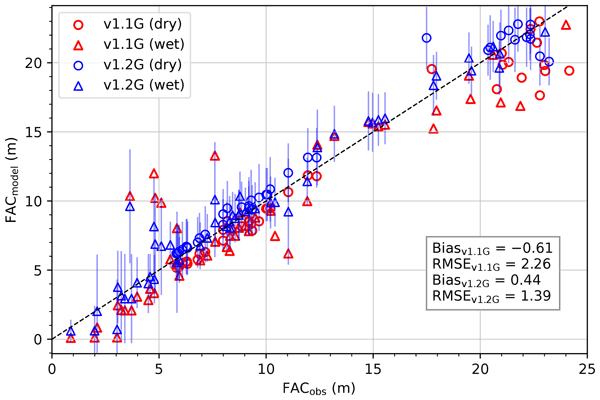
Firn covers the Greenland ice sheet (GrIS) and can temporarily prevent mass loss. Here, we present the latest version of our firn model, IMAU-FDM, with an application to the GrIS. We improved the density of fallen snow, the firn densification rate and the firn's thermal conductivity. This leads to a higher air content and 10 m temperatures. Furthermore we investigate three case studies and find that the updated model shows greater variability and an increased sensitivity in surface elevation.
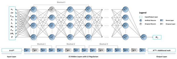
Zhongyang Hu, Peter Kuipers Munneke, Stef Lhermitte, Maaike Izeboud, and Michiel van den Broeke
The Cryosphere, 15, 5639–5658, https://doi.org/10.5194/tc-15-5639-2021, https://doi.org/10.5194/tc-15-5639-2021, 2021
Short summary
Short summary
Antarctica is shrinking, and part of the mass loss is caused by higher temperatures leading to more snowmelt. We use computer models to estimate the amount of melt, but this can be inaccurate – specifically in the areas with the most melt. This is because the model cannot account for small, darker areas like rocks or darker ice. Thus, we trained a computer using artificial intelligence and satellite images that showed these darker areas. The model computed an improved estimate of melt.
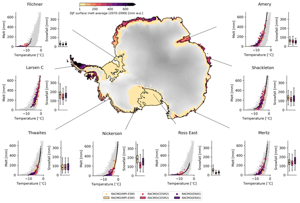
Marte Gé Hofsteenge, Willem Jan van de Berg, Christiaan van Dalum, Kristiina Verro, Maurice van Tiggelen, and Michiel van den Broeke
The Cryosphere, 20, 4747–4766, https://doi.org/10.5194/tc-20-4747-2026, https://doi.org/10.5194/tc-20-4747-2026, 2026
Short summary
Short summary
We use a regional climate model to study how surface melt on Antarctic ice shelves responds to air temperature. The relationship is strongly non-linear, mainly due to feedbacks in surface albedo, with other energy sources also contributing. Currently colder, drier, and more stable ice shelves will experience more melt at the same temperature than ice shelves in wetter climates, highlighting their vulnerability to fracturing, ice shelf instability, and contributions to global sea-level rise.
Sanne B. M. Veldhuijsen, Peter Kuipers Munneke, Willem Jan van de Berg, Michiel R. van den Broeke, and Luke D. Trusel
EGUsphere, https://doi.org/10.5194/egusphere-2026-3453, https://doi.org/10.5194/egusphere-2026-3453, 2026
This preprint is open for discussion and under review for The Cryosphere (TC).
Short summary
Short summary
Antarctica has floating ice shelves around its perimeter that provide stability to the ice sheet. As temperature rises, snow on the ice shelves may melt away, and ponding of meltwater may cause the ice shelves to collapse. If that happens, Antarctica may start to lose ice faster than before, resulting in accelerated sea-level rise. The tool presented in this article will be used in simulations of future climate to determine when climate change leads to collapse of the ice shelves in Antarctica.
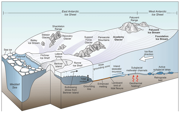
Neil Ross, Rebecca J. Sanderson, Bernd Kulessa, Martin Siegert, Guy J. G. Paxman, Keir A. Nichols, Matthew R. Siegfried, Stewart S. R. Jamieson, Michael J. Bentley, Tom A. Jordan, Christine L. Batchelor, David Small, Olaf Eisen, Kate Winter, Robert G. Bingham, S. Louise Callard, Rachel Carr, Christine F. Dow, Helen A. Fricker, Emily Hill, Benjamin H. Hills, Coen Hofstede, Hafeez Jeofry, Felipe Napoleoni, and Wilson Sauthoff
The Cryosphere, 20, 3705–3737, https://doi.org/10.5194/tc-20-3705-2026, https://doi.org/10.5194/tc-20-3705-2026, 2026
Short summary
Short summary
We review research about a group of fast-flowing Antarctic ice streams, the Foundation-Patuxent-Academy System. Previously, we knew little about how these ice streams flow, how they interact with each other and the ocean, what their geological history was, and how they might evolve in a warming world. By reviewing existing research, we have identified the future research needed to determine how these ice streams function, and how they might contribute to future global sea level rise.
Maud Bernat, Etienne Berthier, Amaury Dehecq, Romain Hugonnet, Joaquin M. C. Belart, Naomi Ochwat, Peter Kuipers Munneke, Elizabeth Case, Ted Scambos, Louis-Marie Gauer, and David Youssefi
The Cryosphere, 20, 3025–3049, https://doi.org/10.5194/tc-20-3025-2026, https://doi.org/10.5194/tc-20-3025-2026, 2026
Short summary
Short summary
The Antarctic Peninsula is a mountainous region containing an ice sheet and peripheral glaciers. Differences remain between the methods used to estimate its mass changes. We use thousands of digital elevation models derived from high resolution stereoscopic images to calculate a new estimate of mass changes. We find that between 2007 and 2021, the ice sheet lost -28±6Gt/a and its peripheral glaciers -14±3Gt/a. We highlight the importance of resolving fine-scale changes in complex coastal areas.
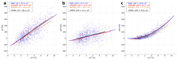
Fredrik Boberg, Xavier Fettweis, Nicolaj Hansen, Ruth Mottram, and Michiel R. van den Broeke
The Cryosphere, 20, 2947–2960, https://doi.org/10.5194/tc-20-2947-2026, https://doi.org/10.5194/tc-20-2947-2026, 2026
Short summary
Short summary
An ensemble of regional climate model simulations is used to estimate the 21st century change in precipitation on the Greenland ice sheet. For the end of the century, the change is in the range 40 to 170 Gt per year, depending on the emission scenario. Using annual values of 2 m air temperature and precipitation, we estimate an increase in precipitation of 35 Gt per year for every degree of warming.
Samuel M. Tax, Maurice van Tiggelen, Thirza N. Feenstra, Paul C. J. P. Smeets, Srinidhi N. Gadde, Christiaan T. van Dalum, Willem Jan van de Berg, and Michiel R. van den Broeke
EGUsphere, https://doi.org/10.5194/egusphere-2026-1926, https://doi.org/10.5194/egusphere-2026-1926, 2026
Short summary
Short summary
Strong winds can lift snow into the air, which influences the energy exchange between the surface and the atmosphere. We studied this phenomenon over the Greenland Ice Sheet using observations and a climate model. We found that blowing snow traps heat near the surface like a blanket and reflects incoming sunlight like a mirror. Simulating these processes increases the net energy at the surface and improves model accuracy. Therefore, we recommend including these effects in climate models.
Rebecca McCerery, Joseph A. Graly, Christopher L. Hansen, Kate Winter, William P. Gilhooly III, Trinity L. Hamilton, Moses Jatta, Jeff R. Havig, Felipe Napoleoni, Alicia M. Rutledge, Matthew Terrell, Tanya M. Trott, Kayla Woodie, Bernd Kulessa, Sevi Modestou, Hannah Bahrani, Tori Kennedy, Alexandra Messerli, and Kathy Licht
EGUsphere, https://doi.org/10.5194/egusphere-2026-2131, https://doi.org/10.5194/egusphere-2026-2131, 2026
Short summary
Short summary
Ice cores from Isunnguata Sermia’s forefield reveal how proglacial naled and accreted ices form in Greenland. Naledi build up in winter from precipitation and mineral-rich subglacial water, while accreted ice forms in summer through supercooled water upwelling. Geophysical surveys indicate both are fed by subsurface flows potentially originating from the glacier bed hundreds of metres away. Here, we present the first conceptual model of these formations in Greenland.
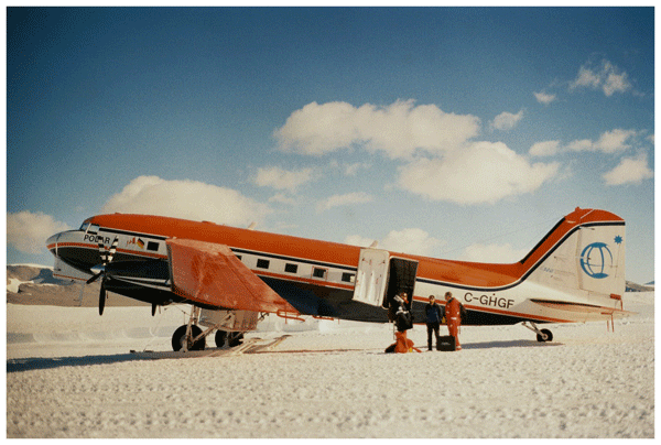
Steven Franke, Daniel Steinhage, Veit Helm, Tobias Binder, Uwe Nixdorf, Heinrich Miller, Angelika Humbert, Daniela Jansen, Graeme Eagles, Hannes Eisermann, Wilfried Jokat, Antonia Ruppel, Reinhard Drews, Alexandra Zuhr, Amelie Driemel, Andreas Walter, Peter Konopatzky, Robin Heß, Antonie Haas, Roland Koppe, Pascal H. Andreas, and Olaf Eisen
The Cryosphere, 20, 2485–2530, https://doi.org/10.5194/tc-20-2485-2026, https://doi.org/10.5194/tc-20-2485-2026, 2026
Short summary
Short summary
This review synthesizes 30 years of Alfred Wegener Institute’s (AWI) airborne radar research in Antarctica and Greenland, detailing six radar systems and their applications in studying ice dynamics, basal properties, and subglacial landscapes. Moreover, it introduces the public release of AWI's airborne radar datasets via the Radar Data over Polar Ice Sheets Viewer and PANGAEA, ensuring findable, accessible, interoperable, and reusable access for future polar research.
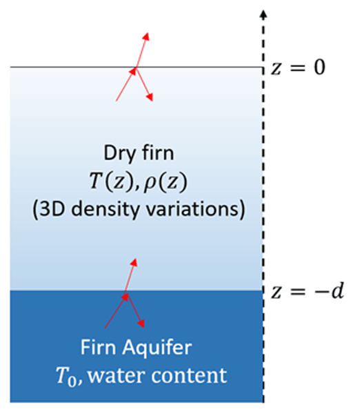
Haokui Xu, Leung Tsang, Julie Miller, Brooke C. Medley, and Joel T. Johnson
The Cryosphere, 20, 2237–2256, https://doi.org/10.5194/tc-20-2237-2026, https://doi.org/10.5194/tc-20-2237-2026, 2026
Short summary
Short summary
This paper provides a physical model to analyze the brightness temperature time series over the firn aquifer in Greenland and Antarctica. The model can match the Vertical polarized and Horizontal polarized brightness temperature time series well. This model provides a potential to study the aquifer water table depth and liquid water content with radiometry.
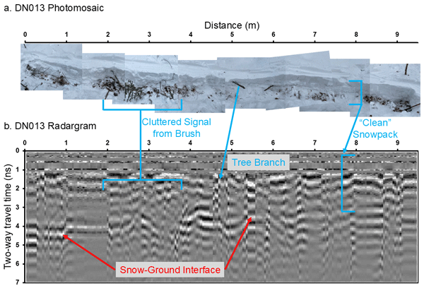
Kajsa Holland-Goon, Randall Bonnell, Daniel McGrath, W. Brad Baxter, Tate Meehan, Ryan Webb, Christopher F. Larsen, Hans-Peter Marshall, Megan Mason, and Carrie Vuyovich
The Cryosphere, 20, 2169–2179, https://doi.org/10.5194/tc-20-2169-2026, https://doi.org/10.5194/tc-20-2169-2026, 2026
Short summary
Short summary
As part of the NASA SnowEx23 campaign, we conducted detailed snowpack experiments in Alaska's boreal forests and Arctic tundra. We collected ground-penetrating radar measurements of snow depth along 44 short transects. We then excavated the snowpack from below the transects and measured snow depth, noting any vegetation and void spaces. We used the detailed in situ measurements to evaluate uncertainties in ground-penetrating radar and airborne lidar methods for snow depth retrieval.
Karla Boxall, Malcolm McMillan, Alan Muir, Sarah Appleby, Sophie Dubber, Noel Gourmelen, Clare Willis, and Joe Phillips
EGUsphere, https://doi.org/10.5194/egusphere-2026-556, https://doi.org/10.5194/egusphere-2026-556, 2026
Short summary
Short summary
Satellite radar altimeters have measured ice sheet elevation since the 1990s, but associated uncertainty estimates are often absent or untested, despite being crucial for efforts to estimate past, present and future sea-level rise. Here, we present a new framework to generate and assess uncertainties associated with historical, current and future radar altimeters. Our results show uncertainty performance varies according to processing method, satellite and region.
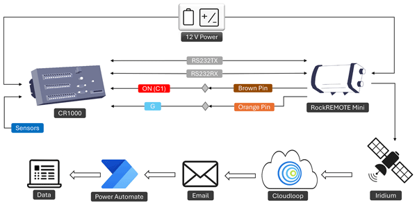
Sunil N. Oulkar, Matthew W. Peacey, Michael Mitrev, Duncan J. Quincey, Bryn Hubbard, Tom Matthews, Ankita S. Oulkar, Katie E. Miles, and Ann V. Rowan
Geosci. Instrum. Method. Data Syst., 15, 75–88, https://doi.org/10.5194/gi-15-75-2026, https://doi.org/10.5194/gi-15-75-2026, 2026
Short summary
Short summary
We designed and tested a system that can record and send data in near real time from extreme and remote locations, such as Mount Everest. Using solar power and satellite communication, the system worked reliably at high altitude, showing it can be applied in other remote regions. This approach will help scientists collect vital information on how the environment is changing in areas that are normally very difficult to study.
Benjamin Heurgue, Charles Amory, Christoph Kittel, Fredrik Boberg, Gaël Durand, Vincent Favier, Xavier Fettweis, Quentin Glaude, Heiko Goelzer, Nicolaj Hansen, Nicolas C. Jourdain, Ruth Mottram, Martin Olesen, Willem Jan Van de Berg, Michiel R. Van den Broeke, and René R. Wijngaard
EGUsphere, https://doi.org/10.5194/egusphere-2026-624, https://doi.org/10.5194/egusphere-2026-624, 2026
Short summary
Short summary
We studied how the Antarctic ice sheet surface mass balance may change by 2100 using three high-resolution climate models forced by the same future climate scenario. While the models agree for present-day conditions, they project very different futures, especially over floating ice shelves. These differences mainly come from how melting, refreezing, and temperature are represented. Our results show that future sea level projections strongly depend on how well models simulate today’s climate.
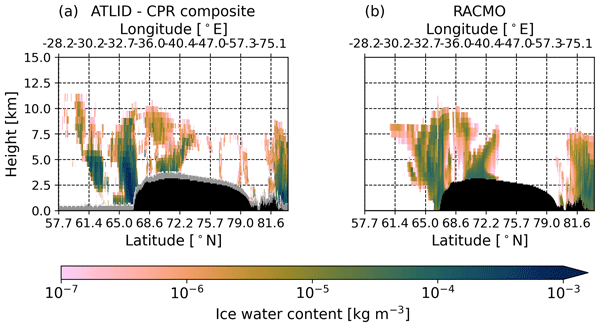
Thirza N. Feenstra, Willem Jan van de Berg, Gerd-Jan van Zadelhoff, David P. Donovan, Christiaan T. van Dalum, and Michiel R. van den Broeke
Atmos. Meas. Tech., 19, 1323–1344, https://doi.org/10.5194/amt-19-1323-2026, https://doi.org/10.5194/amt-19-1323-2026, 2026
Short summary
Short summary
Cloud representation brings large uncertainties in polar climate modeling. We show the first evaluation of Greenland clouds in the Regional Atmospheric Climate Model (RACMO2.4) with new EarthCARE satellite data. Comparing lidar and radar observations and retrieved cloud profiles with co-located RACMO output, we find RACMO captures low ice clouds but underestimates high clouds, mid-altitude liquid clouds, and snowfall. These results highlight EarthCARE's potential to improve polar climate models.
Tesse E. A. van den Aker, Peter Kuipers Munneke, Willem Jan van de Berg, Walter W. Immerzeel, and Michiel R. van den Broeke
EGUsphere, https://doi.org/10.5194/egusphere-2026-462, https://doi.org/10.5194/egusphere-2026-462, 2026
Short summary
Short summary
The firn layer, i.e. permanent snow, regulates how an ice sheet responds to climate change. Firn models are forced with with climate data at time steps from sub-daily to annual in literature, however, implications are barely evaluated. We test the impact of different climate forcing time steps on the modeled firn layer. We conclude that the climate forcing time step (1) affects firn model output, (2) can lead to non-physical behaviour, and (3) that resolving at least a diurnal cycle is required.
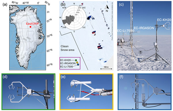
Ida Haven, Hans Christian Steen-Larsen, Laura J. Dietrich, Sonja Wahl, Jason E. Box, Michiel R. van den Broeke, Alun Hubbard, Stephan T. Kral, Joachim Reuder, and Maurice van Tiggelen
The Cryosphere, 20, 573–593, https://doi.org/10.5194/tc-20-573-2026, https://doi.org/10.5194/tc-20-573-2026, 2026
Short summary
Short summary
Three independent Eddy-Covariance measurement systems deployed on top of the Greenland Ice Sheet are compared. Using this dataset, we evaluate the reproducibility and quantify the differences between the systems. The fidelity of two regional climate models in capturing the seasonal variability in the latent and sensible heat flux between the snow surface and the atmosphere is assessed. We identify differences between observations and model simulations, especially during the winter period.
Horst Machguth, Andrew Tedstone, Peter Kuipers Munneke, Max Brils, Brice Noël, Nicole Clerx, Nicolas Jullien, Xavier Fettweis, and Michiel van den Broeke
The Cryosphere, 20, 427–452, https://doi.org/10.5194/tc-20-427-2026, https://doi.org/10.5194/tc-20-427-2026, 2026
Short summary
Short summary
Due to increasing air temperatures, surface melt expands to higher elevations on the Greenland ice sheet. This is visible on satellite imagery in the form of rivers of meltwater running across the surface of the ice sheet. We compare model results of meltwater at high elevations on the ice sheet to satellite observations. We find that each of the models shows strengths and weaknesses. A detailed look into the model results reveals potential reasons for the differences between models.
Valeria Di Biase, Peter Kuipers Munneke, Bert Wouters, Michiel R. van den Broeke, and Maurice van Tiggelen
The Cryosphere, 20, 87–96, https://doi.org/10.5194/tc-20-87-2026, https://doi.org/10.5194/tc-20-87-2026, 2026
Short summary
Short summary
We produce annual maps of Antarctic surface melt volumes from 2012 to 2021 using satellite microwave data. We detect melting days from thresholds on the satellite signal and then use actual melt measurements from weather stations to convert those signals into water‑equivalent volumes. Our maps capture known melt hotspots and show slightly lower totals than climate models. This dataset supports climate and ice‑shelf studies.

Heiko Goelzer, Constantijn J. Berends, Fredrik Boberg, Gael Durand, Tamsin L. Edwards, Xavier Fettweis, Fabien Gillet-Chaulet, Quentin Glaude, Philippe Huybrechts, Sébastien Le clec'h, Ruth Mottram, Brice Noël, Martin Olesen, Charlotte Rahlves, Jeremy Rohmer, Michiel van den Broeke, and Roderik S. W. van de Wal
The Cryosphere, 19, 6887–6906, https://doi.org/10.5194/tc-19-6887-2025, https://doi.org/10.5194/tc-19-6887-2025, 2025
Short summary
Short summary
We present an ensemble of ice sheet model projections for the Greenland ice sheet. The focus is on providing projections that improve our understanding of the range future sea-level rise and the inherent uncertainties over the next 100 to 300 years. Compared to earlier work we more fully account for some of the uncertainties in sea-level projections. We include a wider range of climate model output, more climate change scenarios and we extend projections schematically up to year 2300.
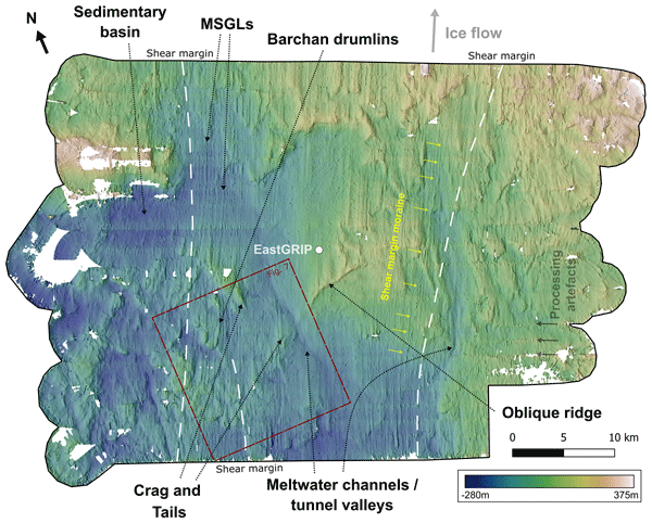
Charlotte M. Carter, Steven Franke, Daniela Jansen, Chris R. Stokes, Veit Helm, John Paden, and Olaf Eisen
The Cryosphere, 19, 5299–5315, https://doi.org/10.5194/tc-19-5299-2025, https://doi.org/10.5194/tc-19-5299-2025, 2025
Short summary
Short summary
The subglacial landforms beneath actively fast-flowing ice in Greenland have not been explored in detail, as digital elevation models have not had a high enough resolution to see these features. We use swath radar imaging to visualise landforms at the onset of an ice stream, revealing mega-scale glacial lineations, that would usually be assumed to be indicative of faster ice flow than the current velocities. Interpretation of the landscape also gives an indication of the properties of the bed.
Sanne B. M. Veldhuijsen, Willem Jan van de Berg, Peter Kuipers Munneke, Nicolaj Hansen, Fredrik Boberg, Christoph Kittel, Charles Amory, and Michiel R. van den Broeke
The Cryosphere, 19, 5157–5173, https://doi.org/10.5194/tc-19-5157-2025, https://doi.org/10.5194/tc-19-5157-2025, 2025
Short summary
Short summary
Perennial firn aquifers (PFAs), year-round bodies of liquid water within firns, can potentially impact ice-shelf and ice-sheet stability. We developed a fast XGBoost firn emulator to predict the 21st-century distribution of PFAs in Antarctica for 12 climatic forcing datasets. Our findings suggest that, in low-emission scenarios, PFAs remain confined to the Antarctic Peninsula. However, in a high-emission scenario, PFAs are projected to expand to a region in West Antarctica and East Antarctica.
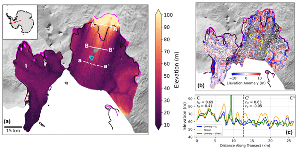
Katie Lowery, Pierre Dutrieux, Paul R. Holland, Anna E. Hogg, Noel Gourmelen, and Benjamin J. Wallis
The Cryosphere, 19, 4893–4911, https://doi.org/10.5194/tc-19-4893-2025, https://doi.org/10.5194/tc-19-4893-2025, 2025
Short summary
Short summary
Using CryoSat-2, we observe monthly changes in the Pine Island Glacier (PIG) ice shelf surface and derive oceanic melt at its base. Basal channels, kilometres wide, are reflected in the ice surface and captured in our observations. We demonstrate that melt is concentrated on the western walls of channels, that channels play a role in grounding pinning points, and that PIG's main channel geometry is inherited upstream of the grounding line. These results highlight the importance of channels to ice shelf stability.
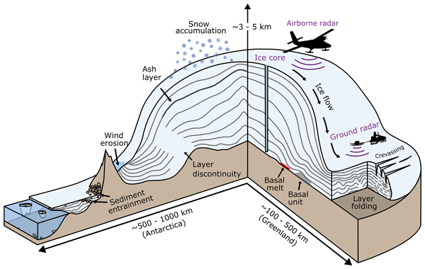
Robert G. Bingham, Julien A. Bodart, Marie G. P. Cavitte, Ailsa Chung, Rebecca J. Sanderson, Johannes C. R. Sutter, Olaf Eisen, Nanna B. Karlsson, Joseph A. MacGregor, Neil Ross, Duncan A. Young, David W. Ashmore, Andreas Born, Winnie Chu, Xiangbin Cui, Reinhard Drews, Steven Franke, Vikram Goel, John W. Goodge, A. Clara J. Henry, Antoine Hermant, Benjamin H. Hills, Nicholas Holschuh, Michelle R. Koutnik, Gwendolyn J.-M. C. Leysinger Vieli, Emma J. MacKie, Elisa Mantelli, Carlos Martín, Felix S. L. Ng, Falk M. Oraschewski, Felipe Napoleoni, Frédéric Parrenin, Sergey V. Popov, Therese Rieckh, Rebecca Schlegel, Dustin M. Schroeder, Martin J. Siegert, Xueyuan Tang, Thomas O. Teisberg, Kate Winter, Shuai Yan, Harry Davis, Christine F. Dow, Tyler J. Fudge, Tom A. Jordan, Bernd Kulessa, Kenichi Matsuoka, Clara J. Nyqvist, Maryam Rahnemoonfar, Matthew R. Siegfried, Shivangini Singh, Vjeran Višnjević, Rodrigo Zamora, and Alexandra Zuhr
The Cryosphere, 19, 4611–4655, https://doi.org/10.5194/tc-19-4611-2025, https://doi.org/10.5194/tc-19-4611-2025, 2025
Short summary
Short summary
The ice sheets covering Antarctica have built up over millenia through successive snowfall events which become buried and preserved as internal surfaces of equal age detectable with ice-penetrating radar. This paper describes an international initiative working together on these archival data to build a comprehensive 3-D picture of how old the ice is everywhere across Antarctica and how this is being used to reconstruct past and to predict future ice and climate behaviour.
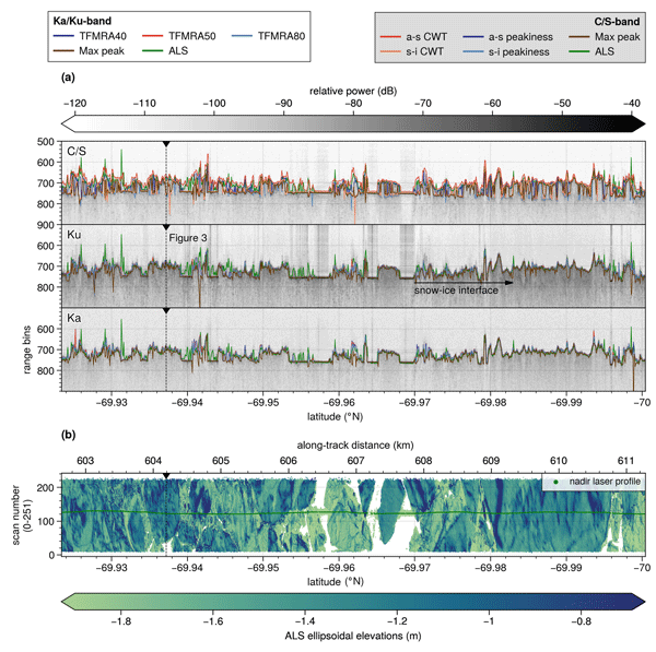
Renée Mie Fredensborg Hansen, Henriette Skourup, Eero Rinne, Arttu Jutila, Isobel R. Lawrence, Andrew Shepherd, Knut Vilhelm Høyland, Jilu Li, Fernando Rodriguez-Morales, Sebastian Bjerregaaard Simonsen, Jeremy Wilkinson, Gaelle Veyssiere, Donghui Yi, René Forsberg, and Taniâ Gil Duarte Casal
The Cryosphere, 19, 4167–4192, https://doi.org/10.5194/tc-19-4167-2025, https://doi.org/10.5194/tc-19-4167-2025, 2025
Short summary
Short summary
An airborne campaign collected unprecedented coincident multi-frequency radar and lidar data over sea ice along a CryoSat-2 and ICESat-2 (CRYO2ICE) orbit in the Weddell Sea, useful for evaluating microwave snow penetration. Ka-band and Ku-band had limited penetration with significant contributions from the air–snow interface, contradicting traditional assumptions with discrepancies between commonly used C/S-band "snow-radar" methodologies, all challenging comparisons of airborne and spaceborne estimates.
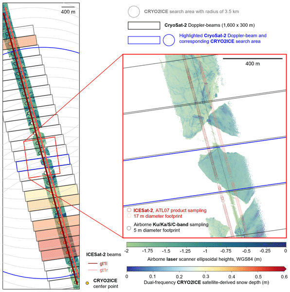
Renée Mie Fredensborg Hansen, Henriette Skourup, Eero Rinne, Arttu Jutila, Isobel R. Lawrence, Andrew Shepherd, Knut Vilhelm Høyland, Jilu Li, Fernando Rodriguez-Morales, Sebastian Bjerregaaard Simonsen, Jeremy Wilkinson, Gaelle Veyssiere, Donghui Yi, René Forsberg, and Taniâ Gil Duarte Casal
The Cryosphere, 19, 4193–4209, https://doi.org/10.5194/tc-19-4193-2025, https://doi.org/10.5194/tc-19-4193-2025, 2025
Short summary
Short summary
An airborne campaign collected unprecedented coincident multi-frequency radar and lidar data over sea ice along a CryoSat-2 and ICESat-2 (CRYO2ICE) orbit in the Weddell Sea, useful for evaluating microwave snow penetration. Ka-band and Ku-band had limited penetration with significant contributions from the air–snow interface, contradicting traditional assumptions with discrepancies between commonly used C/S-band "snow-radar" methodologies, all challenging comparisons of airborne and spaceborne estimates.
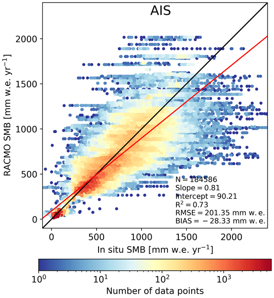
Christiaan T. van Dalum, Willem Jan van de Berg, Michiel R. van den Broeke, and Maurice van Tiggelen
The Cryosphere, 19, 4061–4090, https://doi.org/10.5194/tc-19-4061-2025, https://doi.org/10.5194/tc-19-4061-2025, 2025
Short summary
Short summary
In this study, we present a new surface mass balance (SMB) and near-surface climate product for Antarctica with the regional climate model RACMO2.4p1. We assess the impact of major model updates on the climate of Antarctica. Locally, the SMB has changed substantially but also agrees well with observations. In addition, we show that the SMB components, surface energy budget, albedo, pressure, temperature, and wind speed compare well with in situ and remote sensing observations.
Maurice van Tiggelen, Paul C. J. P. Smeets, Carleen H. Reijmer, Peter Kuipers Munneke, and Michiel R. van den Broeke
Earth Syst. Sci. Data, 17, 4933–4955, https://doi.org/10.5194/essd-17-4933-2025, https://doi.org/10.5194/essd-17-4933-2025, 2025
Short summary
Short summary
This paper describes the measurements from the 19 IMAU (Institute for Marine and Atmospheric research Utrecht) automatic weather stations that operated on the Antarctic ice sheet from 1995 through 2022. These stations also measured the net surface radiation and surface height change, allowing for the quantification of the surface energy and mass balance at hourly resolution. These data are invaluable for the evaluation of atmospheric models and for the detection of climatological changes.
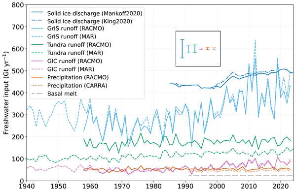
Anneke L. Vries, Willem Jan van de Berg, Brice Noël, Lorenz Meire, and Michiel R. van den Broeke
The Cryosphere, 19, 3897–3914, https://doi.org/10.5194/tc-19-3897-2025, https://doi.org/10.5194/tc-19-3897-2025, 2025
Short summary
Short summary
Freshwater flows into Greenland's fjords from various sources. Solid ice discharge (e.g. calving icebergs) dominates freshwater input in the southeast and northwest. In contrast, in the southwest, runoff from the ice sheet and tundra are the most significant. Seasonal data revealed that fjord precipitation and tundra runoff contribute up to 11 % and 35 % of the monthly freshwater input, respectively. Our results provide valuable input for ocean models and for researchers studying fjord ecosystems.
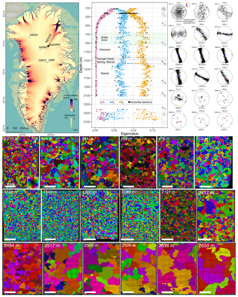
Nicolas Stoll, Ilka Weikusat, Daniela Jansen, Paul Bons, Kyra Darányi, Julien Westhoff, María-Gema Llorens, David Wallis, Jan Eichler, Tomotaka Saruya, Tomoyuki Homma, Sune Olander Rasmussen, Giulia Sinnl, Anders Svensson, Martyn Drury, Frank Wilhelms, Sepp Kipfstuhl, Dorthe Dahl-Jensen, and Johanna Kerch
The Cryosphere, 19, 3805–3830, https://doi.org/10.5194/tc-19-3805-2025, https://doi.org/10.5194/tc-19-3805-2025, 2025
Short summary
Short summary
A better understanding of ice flow requires more observational data. The EastGRIP core is the first ice core through an active ice stream. We discuss crystal orientation data determining the present deformation regimes. A comparison with other deep cores shows the unique properties of EastGRIP and shows that deep ice likely originates from the Eemian. We further show that the overall plug flow of NEGIS is characterised by many small-scale variations, which remain to be considered in ice flow models.
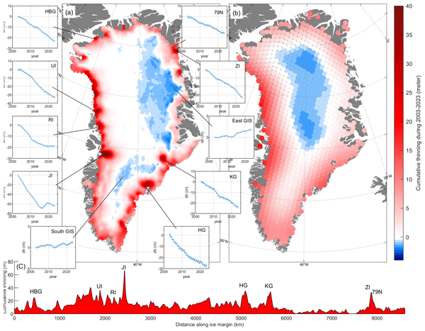
Shfaqat A. Khan, Helene Seroussi, Mathieu Morlighem, William Colgan, Veit Helm, Gong Cheng, Danjal Berg, Valentina R. Barletta, Nicolaj K. Larsen, William Kochtitzky, Michiel van den Broeke, Kurt H. Kjær, Andy Aschwanden, Brice Noël, Jason E. Box, Joseph A. MacGregor, Robert S. Fausto, Kenneth D. Mankoff, Ian M. Howat, Kuba Oniszk, Dominik Fahrner, Anja Løkkegaard, Eigil Y. H. Lippert, Alicia Bråtner, and Javed Hassan
Earth Syst. Sci. Data, 17, 3047–3071, https://doi.org/10.5194/essd-17-3047-2025, https://doi.org/10.5194/essd-17-3047-2025, 2025
Short summary
Short summary
The surface elevation of the Greenland Ice Sheet is changing due to surface mass balance processes and ice dynamics, each exhibiting distinct spatiotemporal patterns. Here, we employ satellite and airborne altimetry data with fine spatial (1 km) and temporal (monthly) resolutions to document this spatiotemporal evolution from 2003 to 2023. This dataset of fine-resolution altimetry data in both space and time will support studies of ice mass loss and be useful for GIS ice sheet modeling.
Amy E. Swiggs, Isobel R. Lawrence, and Andrew Shepherd
EGUsphere, https://doi.org/10.5194/egusphere-2025-693, https://doi.org/10.5194/egusphere-2025-693, 2025
Preprint withdrawn
Short summary
Short summary
We produce a new sea ice concentration product in the Canadian Arctic. This region is vital for shipping, sea ice dependent species, and the movement of sea ice and freshwater. We find that the new dataset agrees well with existing sensors. As it is sensitive to leads, it can detect fine-scale sea ice features, and generally resolves a lower sea ice concentration for this reason. This different approach is important for monitoring sea ice dynamics in a changing climate.
Maria T. Kappelsberger, Martin Horwath, Eric Buchta, Matthias O. Willen, Ludwig Schröder, Sanne B. M. Veldhuijsen, Peter Kuipers Munneke, and Michiel R. van den Broeke
The Cryosphere, 18, 4355–4378, https://doi.org/10.5194/tc-18-4355-2024, https://doi.org/10.5194/tc-18-4355-2024, 2024
Short summary
Short summary
The interannual variations in the height of the Antarctic Ice Sheet (AIS) are mainly due to natural variations in snowfall. Precise knowledge of these variations is important for the detection of any long-term climatic trends in AIS surface elevation. We present a new product that spatially resolves these height variations over the period 1992–2017. The product combines the strengths of atmospheric modeling results and satellite altimetry measurements.
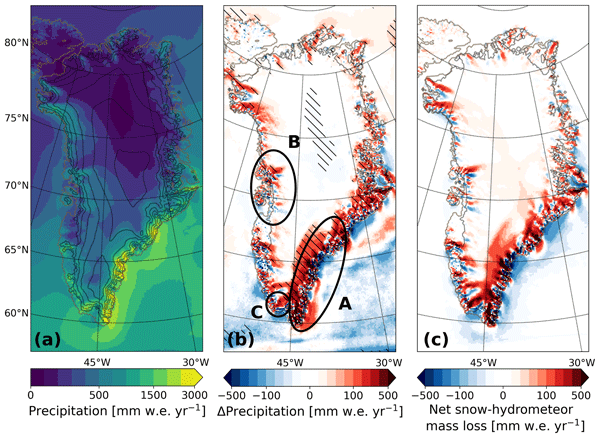
Christiaan T. van Dalum, Willem Jan van de Berg, Srinidhi N. Gadde, Maurice van Tiggelen, Tijmen van der Drift, Erik van Meijgaard, Lambertus H. van Ulft, and Michiel R. van den Broeke
The Cryosphere, 18, 4065–4088, https://doi.org/10.5194/tc-18-4065-2024, https://doi.org/10.5194/tc-18-4065-2024, 2024
Short summary
Short summary
We present a new version of the polar Regional Atmospheric Climate Model (RACMO), version 2.4p1, and show first results for Greenland, Antarctica and the Arctic. We provide an overview of all changes and investigate the impact that they have on the climate of polar regions. By comparing the results with observations and the output from the previous model version, we show that the model performs well regarding the surface mass balance of the ice sheets and near-surface climate.
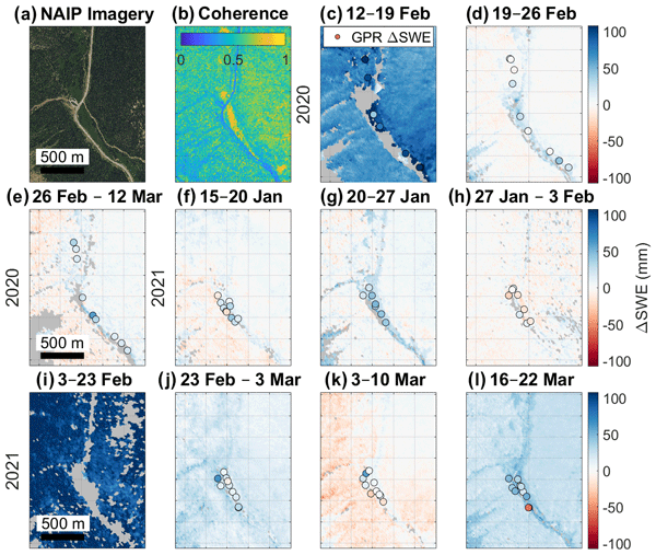
Randall Bonnell, Daniel McGrath, Jack Tarricone, Hans-Peter Marshall, Ella Bump, Caroline Duncan, Stephanie Kampf, Yunling Lou, Alex Olsen-Mikitowicz, Megan Sears, Keith Williams, Lucas Zeller, and Yang Zheng
The Cryosphere, 18, 3765–3785, https://doi.org/10.5194/tc-18-3765-2024, https://doi.org/10.5194/tc-18-3765-2024, 2024
Short summary
Short summary
Snow provides water for billions of people, but the amount of snow is difficult to detect remotely. During the 2020 and 2021 winters, a radar was flown over mountains in Colorado, USA, to measure the amount of snow on the ground, while our team collected ground observations to test the radar technique’s capabilities. The technique yielded accurate measurements of the snowpack that had good correlation with ground measurements, making it a promising application for the upcoming NISAR satellite.
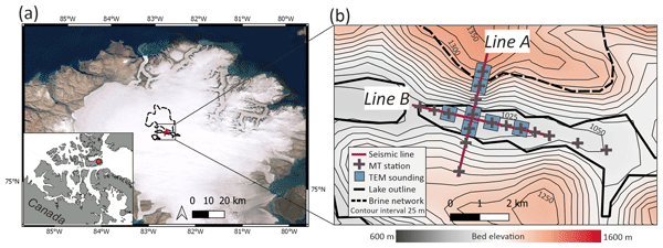
Siobhan F. Killingbeck, Anja Rutishauser, Martyn J. Unsworth, Ashley Dubnick, Alison S. Criscitiello, James Killingbeck, Christine F. Dow, Tim Hill, Adam D. Booth, Brittany Main, and Eric Brossier
The Cryosphere, 18, 3699–3722, https://doi.org/10.5194/tc-18-3699-2024, https://doi.org/10.5194/tc-18-3699-2024, 2024
Short summary
Short summary
A subglacial lake was proposed to exist beneath Devon Ice Cap in the Canadian Arctic based on the analysis of airborne data. Our study presents a new interpretation of the subglacial material beneath the Devon Ice Cap from surface-based geophysical data. We show that there is no evidence of subglacial water, and the subglacial lake has likely been misidentified. Re-evaluation of the airborne data shows that overestimation of a critical processing parameter has likely occurred in prior studies.
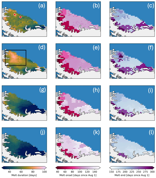
Marissa E. Dattler, Brooke Medley, and C. Max Stevens
The Cryosphere, 18, 3613–3631, https://doi.org/10.5194/tc-18-3613-2024, https://doi.org/10.5194/tc-18-3613-2024, 2024
Short summary
Short summary
We developed an algorithm based on combining models and satellite observations to identify the presence of surface melt on the Antarctic Ice Sheet. We find that this method works similarly to previous methods by assessing 13 sites and the Larsen C ice shelf. Unlike previous methods, this algorithm is based on physical parameters, and updates to this method could allow the meltwater present on the Antarctic Ice Sheet to be quantified instead of simply detected.
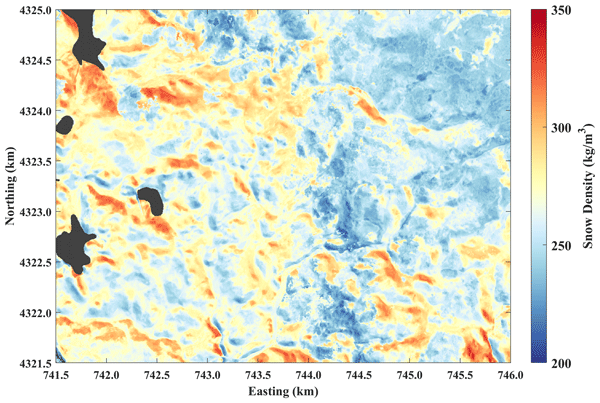
Tate G. Meehan, Ahmad Hojatimalekshah, Hans-Peter Marshall, Elias J. Deeb, Shad O'Neel, Daniel McGrath, Ryan W. Webb, Randall Bonnell, Mark S. Raleigh, Christopher Hiemstra, and Kelly Elder
The Cryosphere, 18, 3253–3276, https://doi.org/10.5194/tc-18-3253-2024, https://doi.org/10.5194/tc-18-3253-2024, 2024
Short summary
Short summary
Snow water equivalent (SWE) is a critical parameter for yearly water supply forecasting and can be calculated by multiplying the snow depth by the snow density. We combined high-spatial-resolution snow depth information with ground-based radar measurements to solve for snow density. Extrapolated density estimates over our study area resolved detailed patterns that agree with the known interactions of snow with wind, terrain, and vegetation and were utilized in the calculation of SWE.
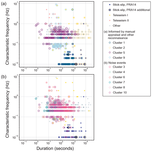
Rebecca B. Latto, Ross J. Turner, Anya M. Reading, Sue Cook, Bernd Kulessa, and J. Paul Winberry
The Cryosphere, 18, 2081–2101, https://doi.org/10.5194/tc-18-2081-2024, https://doi.org/10.5194/tc-18-2081-2024, 2024
Short summary
Short summary
Seismic catalogues are potentially rich sources of information on glacier processes. In a companion study, we constructed an event catalogue for seismic data from the Whillans Ice Stream. Here, we provide a semi-automated workflow for consistent catalogue analysis using an unsupervised cluster analysis. We discuss the defining characteristics of identified signal types found in this catalogue and possible mechanisms for the underlying glacier processes and noise sources.
Sanne B. M. Veldhuijsen, Willem Jan van de Berg, Peter Kuipers Munneke, and Michiel R. van den Broeke
The Cryosphere, 18, 1983–1999, https://doi.org/10.5194/tc-18-1983-2024, https://doi.org/10.5194/tc-18-1983-2024, 2024
Short summary
Short summary
We use the IMAU firn densification model to simulate the 21st-century evolution of Antarctic firn air content. Ice shelves on the Antarctic Peninsula and the Roi Baudouin Ice Shelf in Dronning Maud Land are particularly vulnerable to total firn air content (FAC) depletion. Our results also underline the potentially large vulnerability of low-accumulation ice shelves to firn air depletion through ice slab formation.
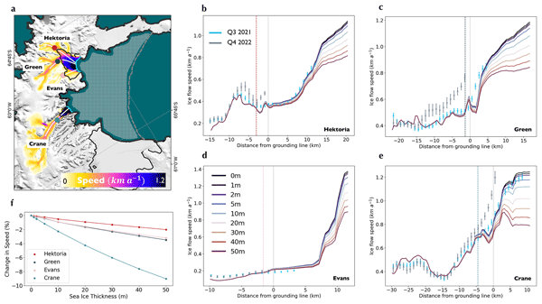
Trystan Surawy-Stepney, Anna E. Hogg, Stephen L. Cornford, Benjamin J. Wallis, Benjamin J. Davison, Heather L. Selley, Ross A. W. Slater, Elise K. Lie, Livia Jakob, Andrew Ridout, Noel Gourmelen, Bryony I. D. Freer, Sally F. Wilson, and Andrew Shepherd
The Cryosphere, 18, 977–993, https://doi.org/10.5194/tc-18-977-2024, https://doi.org/10.5194/tc-18-977-2024, 2024
Short summary
Short summary
Here, we use satellite observations and an ice flow model to quantify the impact of sea ice buttressing on ice streams on the Antarctic Peninsula. The evacuation of 11-year-old landfast sea ice in the Larsen B embayment on the East Antarctic Peninsula in January 2022 was closely followed by major changes in the calving behaviour and acceleration (30 %) of the ocean-terminating glaciers. Our results show that sea ice buttressing had a negligible direct role in the observed dynamic changes.
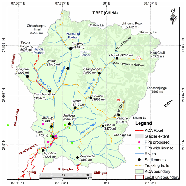
Alton C. Byers, Marcelo Somos-Valenzuela, Dan H. Shugar, Daniel McGrath, Mohan B. Chand, and Ram Avtar
The Cryosphere, 18, 711–717, https://doi.org/10.5194/tc-18-711-2024, https://doi.org/10.5194/tc-18-711-2024, 2024
Short summary
Short summary
In spite of enhanced technologies, many large cryospheric events remain unreported because of their remoteness, inaccessibility, or poor communications. In this Brief communication, we report on a large ice-debris avalanche that occurred sometime between 16 and 21 August 2022 in the Kanchenjunga Conservation Area (KCA), eastern Nepal.
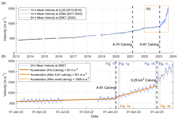
Oliver J. Marsh, Adrian J. Luckman, and Dominic A. Hodgson
The Cryosphere, 18, 705–710, https://doi.org/10.5194/tc-18-705-2024, https://doi.org/10.5194/tc-18-705-2024, 2024
Short summary
Short summary
The Brunt Ice Shelf has accelerated rapidly after calving an iceberg in January 2023. A decade of GPS data show that the rate of acceleration in August 2023 was 30 times higher than before calving, and velocity has doubled in 6 months. Satellite velocity maps show the extent of the change. The acceleration is due to loss of contact between the ice shelf and a pinning point known as the McDonald Ice Rumples. The observations highlight how iceberg calving can directly impact ice shelves.
Baptiste Vandecrux, Robert S. Fausto, Jason E. Box, Federico Covi, Regine Hock, Åsa K. Rennermalm, Achim Heilig, Jakob Abermann, Dirk van As, Elisa Bjerre, Xavier Fettweis, Paul C. J. P. Smeets, Peter Kuipers Munneke, Michiel R. van den Broeke, Max Brils, Peter L. Langen, Ruth Mottram, and Andreas P. Ahlstrøm
The Cryosphere, 18, 609–631, https://doi.org/10.5194/tc-18-609-2024, https://doi.org/10.5194/tc-18-609-2024, 2024
Short summary
Short summary
How fast is the Greenland ice sheet warming? In this study, we compiled 4500+ temperature measurements at 10 m below the ice sheet surface (T10m) from 1912 to 2022. We trained a machine learning model on these data and reconstructed T10m for the ice sheet during 1950–2022. After a slight cooling during 1950–1985, the ice sheet warmed at a rate of 0.7 °C per decade until 2022. Climate models showed mixed results compared to our observations and underestimated the warming in key regions.
Lucas Zeller, Daniel McGrath, Scott W. McCoy, and Jonathan Jacquet
The Cryosphere, 18, 525–541, https://doi.org/10.5194/tc-18-525-2024, https://doi.org/10.5194/tc-18-525-2024, 2024
Short summary
Short summary
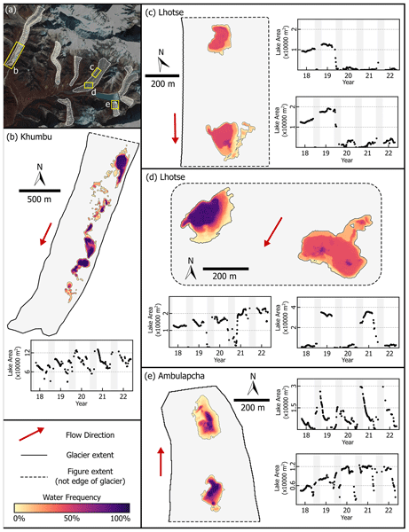
In this study we developed methods for automatically identifying supraglacial lakes in multiple satellite imagery sources for eight glaciers in Nepal. We identified a substantial seasonal variability in lake area, which was as large as the variability seen across entire decades. These complex patterns are not captured in existing regional-scale datasets. Our findings show that this seasonal variability must be accounted for in order to interpret long-term changes in debris-covered glaciers.
Louise Sandberg Sørensen, Rasmus Bahbah, Sebastian B. Simonsen, Natalia Havelund Andersen, Jade Bowling, Noel Gourmelen, Alex Horton, Nanna B. Karlsson, Amber Leeson, Jennifer Maddalena, Malcolm McMillan, Anne Solgaard, and Birgit Wessel
The Cryosphere, 18, 505–523, https://doi.org/10.5194/tc-18-505-2024, https://doi.org/10.5194/tc-18-505-2024, 2024
Short summary
Short summary
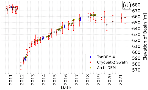
Under the right topographic and hydrological conditions, lakes may form beneath the large ice sheets. Some of these subglacial lakes are active, meaning that they periodically drain and refill. When a subglacial lake drains rapidly, it may cause the ice surface above to collapse, and here we investigate how to improve the monitoring of active subglacial lakes in Greenland by monitoring how their associated collapse basins change over time.
Hélène Seroussi, Vincent Verjans, Sophie Nowicki, Antony J. Payne, Heiko Goelzer, William H. Lipscomb, Ayako Abe-Ouchi, Cécile Agosta, Torsten Albrecht, Xylar Asay-Davis, Alice Barthel, Reinhard Calov, Richard Cullather, Christophe Dumas, Benjamin K. Galton-Fenzi, Rupert Gladstone, Nicholas R. Golledge, Jonathan M. Gregory, Ralf Greve, Tore Hattermann, Matthew J. Hoffman, Angelika Humbert, Philippe Huybrechts, Nicolas C. Jourdain, Thomas Kleiner, Eric Larour, Gunter R. Leguy, Daniel P. Lowry, Chistopher M. Little, Mathieu Morlighem, Frank Pattyn, Tyler Pelle, Stephen F. Price, Aurélien Quiquet, Ronja Reese, Nicole-Jeanne Schlegel, Andrew Shepherd, Erika Simon, Robin S. Smith, Fiammetta Straneo, Sainan Sun, Luke D. Trusel, Jonas Van Breedam, Peter Van Katwyk, Roderik S. W. van de Wal, Ricarda Winkelmann, Chen Zhao, Tong Zhang, and Thomas Zwinger
The Cryosphere, 17, 5197–5217, https://doi.org/10.5194/tc-17-5197-2023, https://doi.org/10.5194/tc-17-5197-2023, 2023
Short summary
Short summary
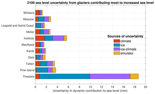
Mass loss from Antarctica is a key contributor to sea level rise over the 21st century, and the associated uncertainty dominates sea level projections. We highlight here the Antarctic glaciers showing the largest changes and quantify the main sources of uncertainty in their future evolution using an ensemble of ice flow models. We show that on top of Pine Island and Thwaites glaciers, Totten and Moscow University glaciers show rapid changes and a strong sensitivity to warmer ocean conditions.
Baptiste Vandecrux, Jason E. Box, Andreas P. Ahlstrøm, Signe B. Andersen, Nicolas Bayou, William T. Colgan, Nicolas J. Cullen, Robert S. Fausto, Dominik Haas-Artho, Achim Heilig, Derek A. Houtz, Penelope How, Ionut Iosifescu Enescu, Nanna B. Karlsson, Rebecca Kurup Buchholz, Kenneth D. Mankoff, Daniel McGrath, Noah P. Molotch, Bianca Perren, Maiken K. Revheim, Anja Rutishauser, Kevin Sampson, Martin Schneebeli, Sandy Starkweather, Simon Steffen, Jeff Weber, Patrick J. Wright, Henry Jay Zwally, and Konrad Steffen
Earth Syst. Sci. Data, 15, 5467–5489, https://doi.org/10.5194/essd-15-5467-2023, https://doi.org/10.5194/essd-15-5467-2023, 2023
Short summary
Short summary
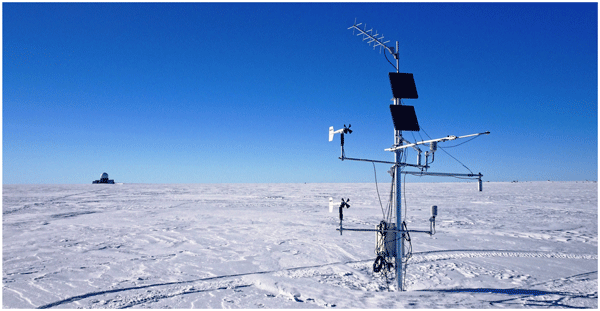
The Greenland Climate Network (GC-Net) comprises stations that have been monitoring the weather on the Greenland Ice Sheet for over 30 years. These stations are being replaced by newer ones maintained by the Geological Survey of Denmark and Greenland (GEUS). The historical data were reprocessed to improve their quality, and key information about the weather stations has been compiled. This augmented dataset is available at https://doi.org/10.22008/FK2/VVXGUT (Steffen et al., 2022).
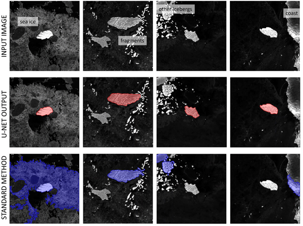
Anne Braakmann-Folgmann, Andrew Shepherd, David Hogg, and Ella Redmond
The Cryosphere, 17, 4675–4690, https://doi.org/10.5194/tc-17-4675-2023, https://doi.org/10.5194/tc-17-4675-2023, 2023
Short summary
Short summary
In this study, we propose a deep neural network to map the extent of giant Antarctic icebergs in Sentinel-1 images automatically. While each manual delineation requires several minutes, our U-net takes less than 0.01 s. In terms of accuracy, we find that U-net outperforms two standard segmentation techniques (Otsu, k-means) in most metrics and is more robust to challenging scenes with sea ice, coast and other icebergs. The absolute median deviation in iceberg area across 191 images is 4.1 %.
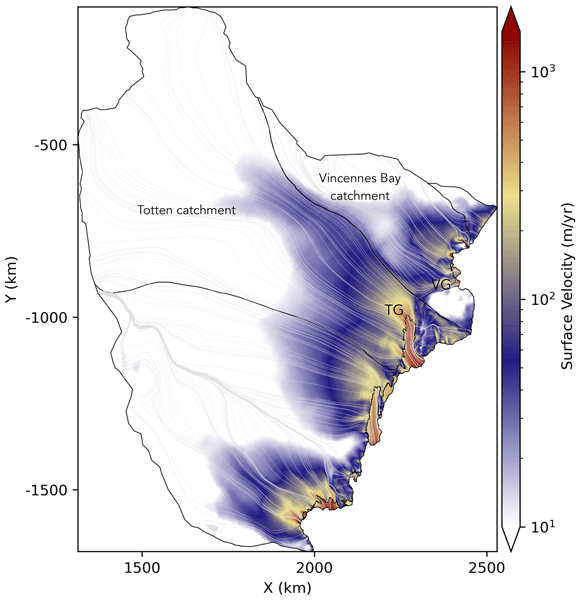
Felicity S. McCormack, Jason L. Roberts, Bernd Kulessa, Alan Aitken, Christine F. Dow, Lawrence Bird, Benjamin K. Galton-Fenzi, Katharina Hochmuth, Richard S. Jones, Andrew N. Mackintosh, and Koi McArthur
The Cryosphere, 17, 4549–4569, https://doi.org/10.5194/tc-17-4549-2023, https://doi.org/10.5194/tc-17-4549-2023, 2023
Short summary
Short summary
Changes in Antarctic surface elevation can cause changes in ice and basal water flow, impacting how much ice enters the ocean. We find that ice and basal water flow could divert from the Totten to the Vanderford Glacier, East Antarctica, under only small changes in the surface elevation, with implications for estimates of ice loss from this region. Further studies are needed to determine when this could occur and if similar diversions could occur elsewhere in Antarctica due to climate change.
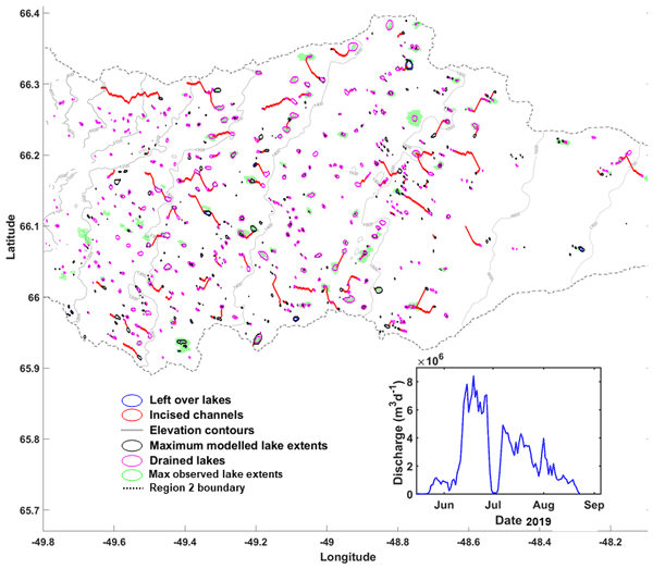
Prateek Gantayat, Alison F. Banwell, Amber A. Leeson, James M. Lea, Dorthe Petersen, Noel Gourmelen, and Xavier Fettweis
Geosci. Model Dev., 16, 5803–5823, https://doi.org/10.5194/gmd-16-5803-2023, https://doi.org/10.5194/gmd-16-5803-2023, 2023
Short summary
Short summary
We developed a new supraglacial hydrology model for the Greenland Ice Sheet. This model simulates surface meltwater routing, meltwater drainage, supraglacial lake (SGL) overflow, and formation of lake ice. The model was able to reproduce 80 % of observed lake locations and provides a good match between the observed and modelled temporal evolution of SGLs.
Lena G. Buth, Valeria Di Biase, Peter Kuipers Munneke, Stef Lhermitte, Sanne B. M. Veldhuijsen, Sophie de Roda Husman, Michiel R. van den Broeke, and Bert Wouters
EGUsphere, https://doi.org/10.5194/egusphere-2023-2000, https://doi.org/10.5194/egusphere-2023-2000, 2023
Preprint archived
Short summary
Short summary
Liquid meltwater which is stored in air bubbles in the compacted snow near the surface of Antarctica can affect ice shelf stability. In order to detect the presence of such firn aquifers over large scales, satellite remote sensing is needed. In this paper, we present our new detection method using radar satellite data as well as the results for the whole Antarctic Peninsula. Firn aquifers are found in the north and northwest of the peninsula, in agreement with locations predicted by models.
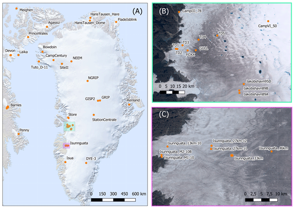
Anja Løkkegaard, Kenneth D. Mankoff, Christian Zdanowicz, Gary D. Clow, Martin P. Lüthi, Samuel H. Doyle, Henrik H. Thomsen, David Fisher, Joel Harper, Andy Aschwanden, Bo M. Vinther, Dorthe Dahl-Jensen, Harry Zekollari, Toby Meierbachtol, Ian McDowell, Neil Humphrey, Anne Solgaard, Nanna B. Karlsson, Shfaqat A. Khan, Benjamin Hills, Robert Law, Bryn Hubbard, Poul Christoffersen, Mylène Jacquemart, Julien Seguinot, Robert S. Fausto, and William T. Colgan
The Cryosphere, 17, 3829–3845, https://doi.org/10.5194/tc-17-3829-2023, https://doi.org/10.5194/tc-17-3829-2023, 2023
Short summary
Short summary
This study presents a database compiling 95 ice temperature profiles from the Greenland ice sheet and peripheral ice caps. Ice viscosity and hence ice flow are highly sensitive to ice temperature. To highlight the value of the database in evaluating ice flow simulations, profiles from the Greenland ice sheet are compared to a modeled temperature field. Reoccurring discrepancies between modeled and observed temperatures provide insight on the difficulties faced when simulating ice temperatures.
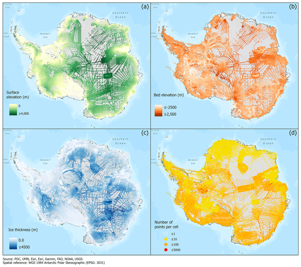
Alice C. Frémand, Peter Fretwell, Julien A. Bodart, Hamish D. Pritchard, Alan Aitken, Jonathan L. Bamber, Robin Bell, Cesidio Bianchi, Robert G. Bingham, Donald D. Blankenship, Gino Casassa, Ginny Catania, Knut Christianson, Howard Conway, Hugh F. J. Corr, Xiangbin Cui, Detlef Damaske, Volkmar Damm, Reinhard Drews, Graeme Eagles, Olaf Eisen, Hannes Eisermann, Fausto Ferraccioli, Elena Field, René Forsberg, Steven Franke, Shuji Fujita, Yonggyu Gim, Vikram Goel, Siva Prasad Gogineni, Jamin Greenbaum, Benjamin Hills, Richard C. A. Hindmarsh, Andrew O. Hoffman, Per Holmlund, Nicholas Holschuh, John W. Holt, Annika N. Horlings, Angelika Humbert, Robert W. Jacobel, Daniela Jansen, Adrian Jenkins, Wilfried Jokat, Tom Jordan, Edward King, Jack Kohler, William Krabill, Mette Kusk Gillespie, Kirsty Langley, Joohan Lee, German Leitchenkov, Carlton Leuschen, Bruce Luyendyk, Joseph MacGregor, Emma MacKie, Kenichi Matsuoka, Mathieu Morlighem, Jérémie Mouginot, Frank O. Nitsche, Yoshifumi Nogi, Ole A. Nost, John Paden, Frank Pattyn, Sergey V. Popov, Eric Rignot, David M. Rippin, Andrés Rivera, Jason Roberts, Neil Ross, Anotonia Ruppel, Dustin M. Schroeder, Martin J. Siegert, Andrew M. Smith, Daniel Steinhage, Michael Studinger, Bo Sun, Ignazio Tabacco, Kirsty Tinto, Stefano Urbini, David Vaughan, Brian C. Welch, Douglas S. Wilson, Duncan A. Young, and Achille Zirizzotti
Earth Syst. Sci. Data, 15, 2695–2710, https://doi.org/10.5194/essd-15-2695-2023, https://doi.org/10.5194/essd-15-2695-2023, 2023
Short summary
Short summary
This paper presents the release of over 60 years of ice thickness, bed elevation, and surface elevation data acquired over Antarctica by the international community. These data are a crucial component of the Antarctic Bedmap initiative which aims to produce a new map and datasets of Antarctic ice thickness and bed topography for the international glaciology and geophysical community.
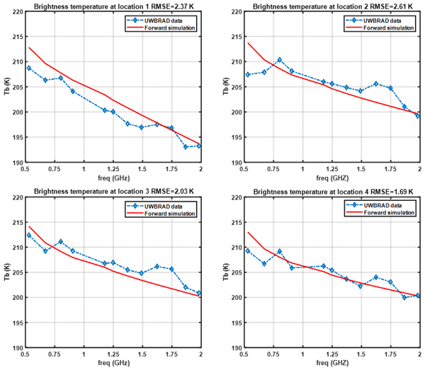
Haokui Xu, Brooke Medley, Leung Tsang, Joel T. Johnson, Kenneth C. Jezek, Marco Brogioni, and Lars Kaleschke
The Cryosphere, 17, 2793–2809, https://doi.org/10.5194/tc-17-2793-2023, https://doi.org/10.5194/tc-17-2793-2023, 2023
Short summary
Short summary
The density profile of polar ice sheets is a major unknown in estimating the mass loss using lidar tomography methods. In this paper, we show that combing the active radar data and passive radiometer data can provide an estimation of density properties using the new model we implemented in this paper. The new model includes the short and long timescale variations in the firn and also the refrozen layers which are not included in the previous modeling work.
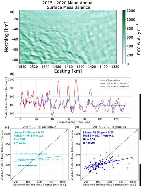
Eric Keenan, Nander Wever, Jan T. M. Lenaerts, and Brooke Medley
Geosci. Model Dev., 16, 3203–3219, https://doi.org/10.5194/gmd-16-3203-2023, https://doi.org/10.5194/gmd-16-3203-2023, 2023
Short summary
Short summary
Ice sheets gain mass via snowfall. However, snowfall is redistributed by the wind, resulting in accumulation differences of up to a factor of 5 over distances as short as 5 km. These differences complicate estimates of ice sheet contribution to sea level rise. For this reason, we have developed a new model for estimating wind-driven snow redistribution on ice sheets. We show that, over Pine Island Glacier in West Antarctica, the model improves estimates of snow accumulation variability.
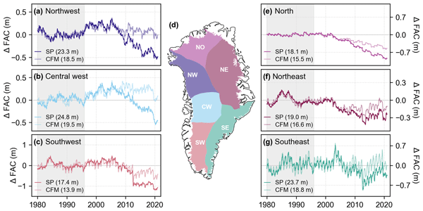
Megan Thompson-Munson, Nander Wever, C. Max Stevens, Jan T. M. Lenaerts, and Brooke Medley
The Cryosphere, 17, 2185–2209, https://doi.org/10.5194/tc-17-2185-2023, https://doi.org/10.5194/tc-17-2185-2023, 2023
Short summary
Short summary
To better understand the Greenland Ice Sheet’s firn layer and its ability to buffer sea level rise by storing meltwater, we analyze firn density observations and output from two firn models. We find that both models, one physics-based and one semi-empirical, simulate realistic density and firn air content when compared to observations. The models differ in their representation of firn air content, highlighting the uncertainty in physical processes and the paucity of deep-firn measurements.
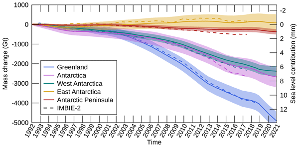
Inès N. Otosaka, Andrew Shepherd, Erik R. Ivins, Nicole-Jeanne Schlegel, Charles Amory, Michiel R. van den Broeke, Martin Horwath, Ian Joughin, Michalea D. King, Gerhard Krinner, Sophie Nowicki, Anthony J. Payne, Eric Rignot, Ted Scambos, Karen M. Simon, Benjamin E. Smith, Louise S. Sørensen, Isabella Velicogna, Pippa L. Whitehouse, Geruo A, Cécile Agosta, Andreas P. Ahlstrøm, Alejandro Blazquez, William Colgan, Marcus E. Engdahl, Xavier Fettweis, Rene Forsberg, Hubert Gallée, Alex Gardner, Lin Gilbert, Noel Gourmelen, Andreas Groh, Brian C. Gunter, Christopher Harig, Veit Helm, Shfaqat Abbas Khan, Christoph Kittel, Hannes Konrad, Peter L. Langen, Benoit S. Lecavalier, Chia-Chun Liang, Bryant D. Loomis, Malcolm McMillan, Daniele Melini, Sebastian H. Mernild, Ruth Mottram, Jeremie Mouginot, Johan Nilsson, Brice Noël, Mark E. Pattle, William R. Peltier, Nadege Pie, Mònica Roca, Ingo Sasgen, Himanshu V. Save, Ki-Weon Seo, Bernd Scheuchl, Ernst J. O. Schrama, Ludwig Schröder, Sebastian B. Simonsen, Thomas Slater, Giorgio Spada, Tyler C. Sutterley, Bramha Dutt Vishwakarma, Jan Melchior van Wessem, David Wiese, Wouter van der Wal, and Bert Wouters
Earth Syst. Sci. Data, 15, 1597–1616, https://doi.org/10.5194/essd-15-1597-2023, https://doi.org/10.5194/essd-15-1597-2023, 2023
Short summary
Short summary
By measuring changes in the volume, gravitational attraction, and ice flow of Greenland and Antarctica from space, we can monitor their mass gain and loss over time. Here, we present a new record of the Earth’s polar ice sheet mass balance produced by aggregating 50 satellite-based estimates of ice sheet mass change. This new assessment shows that the ice sheets have lost (7.5 x 10¹²) t of ice between 1992 and 2020, contributing 21 mm to sea level rise.
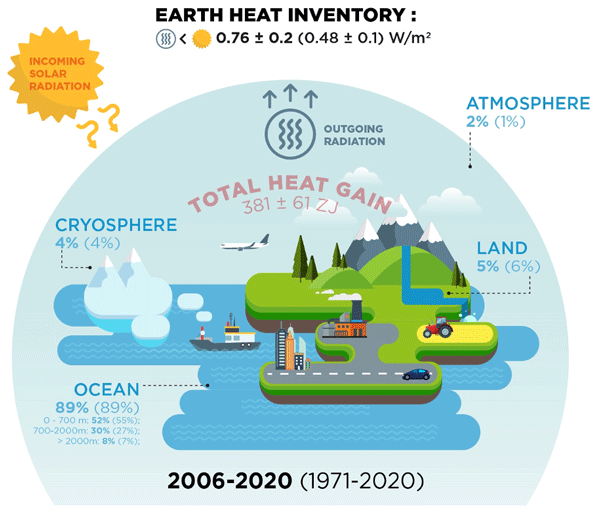
Karina von Schuckmann, Audrey Minière, Flora Gues, Francisco José Cuesta-Valero, Gottfried Kirchengast, Susheel Adusumilli, Fiammetta Straneo, Michaël Ablain, Richard P. Allan, Paul M. Barker, Hugo Beltrami, Alejandro Blazquez, Tim Boyer, Lijing Cheng, John Church, Damien Desbruyeres, Han Dolman, Catia M. Domingues, Almudena García-García, Donata Giglio, John E. Gilson, Maximilian Gorfer, Leopold Haimberger, Maria Z. Hakuba, Stefan Hendricks, Shigeki Hosoda, Gregory C. Johnson, Rachel Killick, Brian King, Nicolas Kolodziejczyk, Anton Korosov, Gerhard Krinner, Mikael Kuusela, Felix W. Landerer, Moritz Langer, Thomas Lavergne, Isobel Lawrence, Yuehua Li, John Lyman, Florence Marti, Ben Marzeion, Michael Mayer, Andrew H. MacDougall, Trevor McDougall, Didier Paolo Monselesan, Jan Nitzbon, Inès Otosaka, Jian Peng, Sarah Purkey, Dean Roemmich, Kanako Sato, Katsunari Sato, Abhishek Savita, Axel Schweiger, Andrew Shepherd, Sonia I. Seneviratne, Leon Simons, Donald A. Slater, Thomas Slater, Andrea K. Steiner, Toshio Suga, Tanguy Szekely, Wim Thiery, Mary-Louise Timmermans, Inne Vanderkelen, Susan E. Wjiffels, Tonghua Wu, and Michael Zemp
Earth Syst. Sci. Data, 15, 1675–1709, https://doi.org/10.5194/essd-15-1675-2023, https://doi.org/10.5194/essd-15-1675-2023, 2023
Short summary
Short summary
Earth's climate is out of energy balance, and this study quantifies how much heat has consequently accumulated over the past decades (ocean: 89 %, land: 6 %, cryosphere: 4 %, atmosphere: 1 %). Since 1971, this accumulated heat reached record values at an increasing pace. The Earth heat inventory provides a comprehensive view on the status and expectation of global warming, and we call for an implementation of this global climate indicator into the Paris Agreement’s Global Stocktake.
Sanne B. M. Veldhuijsen, Willem Jan van de Berg, Max Brils, Peter Kuipers Munneke, and Michiel R. van den Broeke
The Cryosphere, 17, 1675–1696, https://doi.org/10.5194/tc-17-1675-2023, https://doi.org/10.5194/tc-17-1675-2023, 2023
Short summary
Short summary
Firn is the transition of snow to glacier ice and covers 99 % of the Antarctic ice sheet. Knowledge about the firn layer and its variability is important, as it impacts satellite-based estimates of ice sheet mass change. Also, firn contains pores in which nearly all of the surface melt is retained. Here, we improve a semi-empirical firn model and simulate the firn characteristics for the period 1979–2020. We evaluate the performance with field and satellite measures and test its sensitivity.
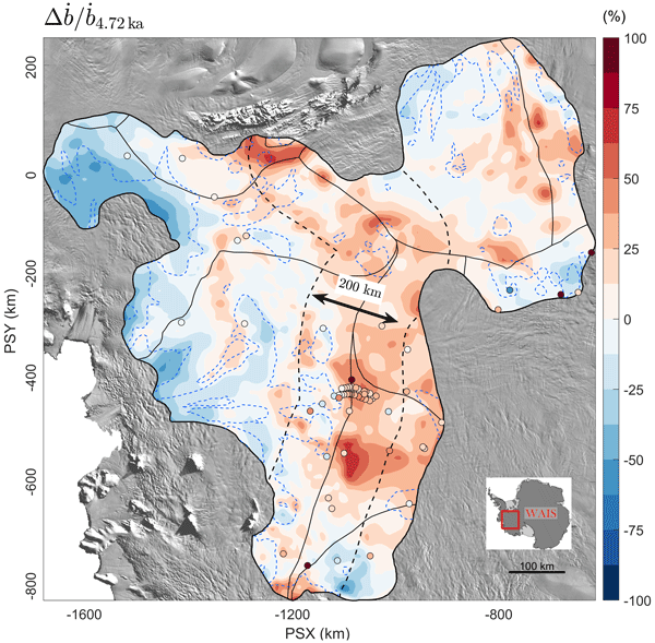
Julien A. Bodart, Robert G. Bingham, Duncan A. Young, Joseph A. MacGregor, David W. Ashmore, Enrica Quartini, Andrew S. Hein, David G. Vaughan, and Donald D. Blankenship
The Cryosphere, 17, 1497–1512, https://doi.org/10.5194/tc-17-1497-2023, https://doi.org/10.5194/tc-17-1497-2023, 2023
Short summary
Short summary
Estimating how West Antarctica will change in response to future climatic change depends on our understanding of past ice processes. Here, we use a reflector widely visible on airborne radar data across West Antarctica to estimate accumulation rates over the past 4700 years. By comparing our estimates with current atmospheric data, we find that accumulation rates were 18 % greater than modern rates. This has implications for our understanding of past ice processes in the region.

Benjamin E. Smith, Brooke Medley, Xavier Fettweis, Tyler Sutterley, Patrick Alexander, David Porter, and Marco Tedesco
The Cryosphere, 17, 789–808, https://doi.org/10.5194/tc-17-789-2023, https://doi.org/10.5194/tc-17-789-2023, 2023
Short summary
Short summary
We use repeated satellite measurements of the height of the Greenland ice sheet to learn about how three computational models of snowfall, melt, and snow compaction represent actual changes in the ice sheet. We find that the models do a good job of estimating how the parts of the ice sheet near the coast have changed but that two of the models have trouble representing surface melt for the highest part of the ice sheet. This work provides suggestions for how to better model snowmelt.
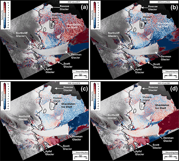
Sarah S. Thompson, Bernd Kulessa, Adrian Luckman, Jacqueline A. Halpin, Jamin S. Greenbaum, Tyler Pelle, Feras Habbal, Jingxue Guo, Lenneke M. Jong, Jason L. Roberts, Bo Sun, and Donald D. Blankenship
The Cryosphere, 17, 157–174, https://doi.org/10.5194/tc-17-157-2023, https://doi.org/10.5194/tc-17-157-2023, 2023
Short summary
Short summary
We use satellite imagery and ice penetrating radar to investigate the stability of the Shackleton system in East Antarctica. We find significant changes in surface structures across the system and observe a significant increase in ice flow speed (up to 50 %) on the floating part of Scott Glacier. We conclude that knowledge remains woefully insufficient to explain recent observed changes in the grounded and floating regions of the system.
Marte G. Hofsteenge, Nicolas J. Cullen, Carleen H. Reijmer, Michiel van den Broeke, Marwan Katurji, and John F. Orwin
The Cryosphere, 16, 5041–5059, https://doi.org/10.5194/tc-16-5041-2022, https://doi.org/10.5194/tc-16-5041-2022, 2022
Short summary
Short summary
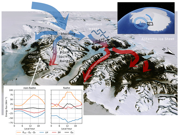
In the McMurdo Dry Valleys (MDV), foehn winds can impact glacial meltwater production and the fragile ecosystem that depends on it. We study these dry and warm winds at Joyce Glacier and show they are caused by a different mechanism than that found for nearby valleys, demonstrating the complex interaction of large-scale winds with the mountains in the MDV. We find that foehn winds increase sublimation of ice, increase heating from the atmosphere, and increase the occurrence and rates of melt.
Vjeran Višnjević, Reinhard Drews, Clemens Schannwell, Inka Koch, Steven Franke, Daniela Jansen, and Olaf Eisen
The Cryosphere, 16, 4763–4777, https://doi.org/10.5194/tc-16-4763-2022, https://doi.org/10.5194/tc-16-4763-2022, 2022
Short summary
Short summary
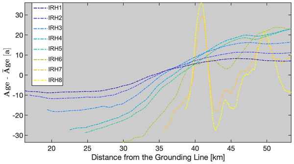
We present a simple way to model the internal layers of an ice shelf and apply the method to the Roi Baudouin Ice Shelf in East Antarctica. Modeled results are compared to measurements obtained by radar. We distinguish between ice directly formed on the shelf and ice transported from the ice sheet, and we map the spatial changes in the volume of the locally accumulated ice. In this context, we discuss the sensitivity of the ice shelf to future changes in surface accumulation and basal melt.

Brooke Medley, Thomas A. Neumann, H. Jay Zwally, Benjamin E. Smith, and C. Max Stevens
The Cryosphere, 16, 3971–4011, https://doi.org/10.5194/tc-16-3971-2022, https://doi.org/10.5194/tc-16-3971-2022, 2022
Short summary
Short summary
Satellite altimeters measure the height or volume change over Earth's ice sheets, but in order to understand how that change translates into ice mass, we must account for various processes at the surface. Specifically, snowfall events generate large, transient increases in surface height, yet snow fall has a relatively low density, which means much of that height change is composed of air. This air signal must be removed from the observed height changes before we can assess ice mass change.
Lena G. Buth, Bert Wouters, Sanne B. M. Veldhuijsen, Stef Lhermitte, Peter Kuipers Munneke, and Michiel R. van den Broeke
The Cryosphere Discuss., https://doi.org/10.5194/tc-2022-127, https://doi.org/10.5194/tc-2022-127, 2022
Manuscript not accepted for further review
Short summary
Short summary
Liquid meltwater which is stored in air bubbles in the compacted snow near the surface of Antarctica can affect ice shelf stability. In order to detect the presence of such firn aquifers over large scales, satellite remote sensing is needed. In this paper, we present our new detection method using radar satellite data as well as the results for the whole Antarctic Peninsula. Firn aquifers are found in the north and northwest of the peninsula, in agreement with locations predicted by models.
Max Brils, Peter Kuipers Munneke, Willem Jan van de Berg, and Michiel van den Broeke
Geosci. Model Dev., 15, 7121–7138, https://doi.org/10.5194/gmd-15-7121-2022, https://doi.org/10.5194/gmd-15-7121-2022, 2022
Short summary
Short summary
Firn covers the Greenland ice sheet (GrIS) and can temporarily prevent mass loss. Here, we present the latest version of our firn model, IMAU-FDM, with an application to the GrIS. We improved the density of fallen snow, the firn densification rate and the firn's thermal conductivity. This leads to a higher air content and 10 m temperatures. Furthermore we investigate three case studies and find that the updated model shows greater variability and an increased sensitivity in surface elevation.
Sophie Goliber, Taryn Black, Ginny Catania, James M. Lea, Helene Olsen, Daniel Cheng, Suzanne Bevan, Anders Bjørk, Charlie Bunce, Stephen Brough, J. Rachel Carr, Tom Cowton, Alex Gardner, Dominik Fahrner, Emily Hill, Ian Joughin, Niels J. Korsgaard, Adrian Luckman, Twila Moon, Tavi Murray, Andrew Sole, Michael Wood, and Enze Zhang
The Cryosphere, 16, 3215–3233, https://doi.org/10.5194/tc-16-3215-2022, https://doi.org/10.5194/tc-16-3215-2022, 2022
Short summary
Short summary
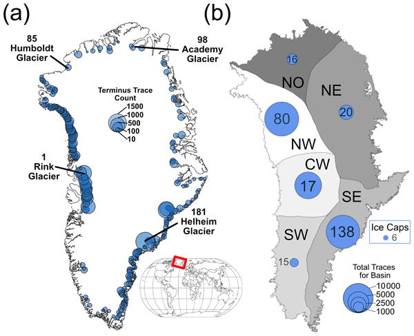
Terminus traces have been used to understand how Greenland's glaciers have changed over time; however, manual digitization is time-intensive, and a lack of coordination leads to duplication of efforts. We have compiled a dataset of over 39 000 terminus traces for 278 glaciers for scientific and machine learning applications. We also provide an overview of an updated version of the Google Earth Engine Digitization Tool (GEEDiT), which has been developed specifically for the Greenland Ice Sheet.
Douglas I. Benn, Adrian Luckman, Jan A. Åström, Anna J. Crawford, Stephen L. Cornford, Suzanne L. Bevan, Thomas Zwinger, Rupert Gladstone, Karen Alley, Erin Pettit, and Jeremy Bassis
The Cryosphere, 16, 2545–2564, https://doi.org/10.5194/tc-16-2545-2022, https://doi.org/10.5194/tc-16-2545-2022, 2022
Short summary
Short summary
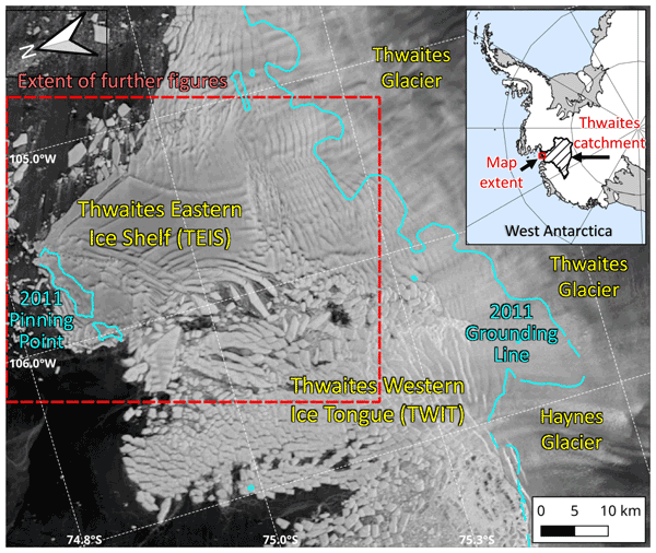
Thwaites Glacier (TG), in West Antarctica, is potentially unstable and may contribute significantly to sea-level rise as global warming continues. Using satellite data, we show that Thwaites Eastern Ice Shelf, the largest remaining floating extension of TG, has started to accelerate as it fragments along a shear zone. Computer modelling does not indicate that fragmentation will lead to imminent glacier collapse, but it is clear that major, rapid, and unpredictable changes are underway.

Johannes Oerlemans, Jack Kohler, and Adrian Luckman
The Cryosphere, 16, 2115–2126, https://doi.org/10.5194/tc-16-2115-2022, https://doi.org/10.5194/tc-16-2115-2022, 2022
Short summary
Short summary
Tunabreen is a 26 km long tidewater glacier. It is the most frequently surging glacier in Svalbard, with four documented surges in the past 100 years. We have modelled this glacier to find out how it reacts to future climate change. Careful calibration was done against the observed length record for the past 100 years. For a 50 m increase in the equilibrium line altitude (ELA) the length of the glacier will be shortened by 10 km after about 100 years.
Christiaan T. van Dalum, Willem Jan van de Berg, and Michiel R. van den Broeke
The Cryosphere, 16, 1071–1089, https://doi.org/10.5194/tc-16-1071-2022, https://doi.org/10.5194/tc-16-1071-2022, 2022
Short summary
Short summary
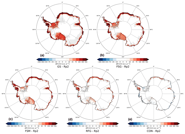
In this study, we improve the regional climate model RACMO2 and investigate the climate of Antarctica. We have implemented a new radiative transfer and snow albedo scheme and do several sensitivity experiments. When fully tuned, the results compare well with observations and snow temperature profiles improve. Moreover, small changes in the albedo and the investigated processes can lead to a strong overestimation of melt, locally leading to runoff and a reduced surface mass balance.
Steven Franke, Daniela Jansen, Tobias Binder, John D. Paden, Nils Dörr, Tamara A. Gerber, Heinrich Miller, Dorthe Dahl-Jensen, Veit Helm, Daniel Steinhage, Ilka Weikusat, Frank Wilhelms, and Olaf Eisen
Earth Syst. Sci. Data, 14, 763–779, https://doi.org/10.5194/essd-14-763-2022, https://doi.org/10.5194/essd-14-763-2022, 2022
Short summary
Short summary
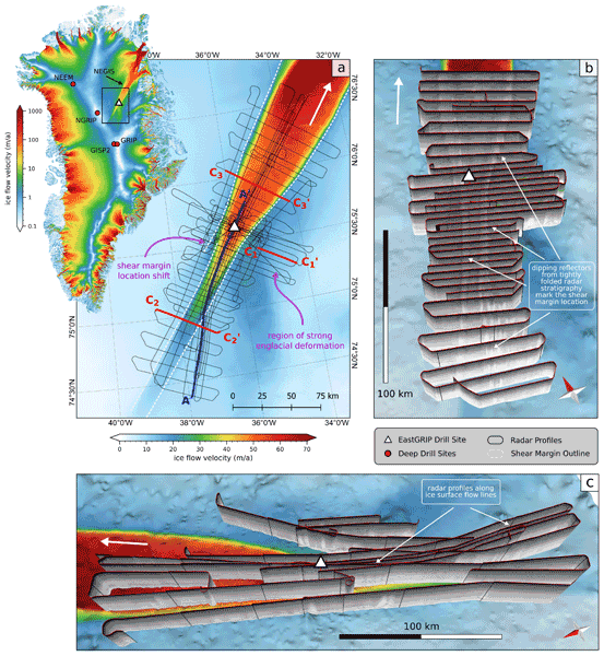
The Northeast Greenland Ice Stream (NEGIS) is the largest ice stream in Greenland. In order to better understand the past and future dynamics of the NEGIS, we present a high-resolution airborne radar data set (EGRIP-NOR-2018) for the onset region of the NEGIS. The survey area is centered at the location of the drill site of the East Greenland Ice-Core Project (EastGRIP), and radar profiles cover both shear margins and are aligned parallel to several flow lines.
Martin Horwath, Benjamin D. Gutknecht, Anny Cazenave, Hindumathi Kulaiappan Palanisamy, Florence Marti, Ben Marzeion, Frank Paul, Raymond Le Bris, Anna E. Hogg, Inès Otosaka, Andrew Shepherd, Petra Döll, Denise Cáceres, Hannes Müller Schmied, Johnny A. Johannessen, Jan Even Øie Nilsen, Roshin P. Raj, René Forsberg, Louise Sandberg Sørensen, Valentina R. Barletta, Sebastian B. Simonsen, Per Knudsen, Ole Baltazar Andersen, Heidi Ranndal, Stine K. Rose, Christopher J. Merchant, Claire R. Macintosh, Karina von Schuckmann, Kristin Novotny, Andreas Groh, Marco Restano, and Jérôme Benveniste
Earth Syst. Sci. Data, 14, 411–447, https://doi.org/10.5194/essd-14-411-2022, https://doi.org/10.5194/essd-14-411-2022, 2022
Short summary
Short summary
Global mean sea-level change observed from 1993 to 2016 (mean rate of 3.05 mm yr−1) matches the combined effect of changes in water density (thermal expansion) and ocean mass. Ocean-mass change has been assessed through the contributions from glaciers, ice sheets, and land water storage or directly from satellite data since 2003. Our budget assessments of linear trends and monthly anomalies utilise new datasets and uncertainty characterisations developed within ESA's Climate Change Initiative.
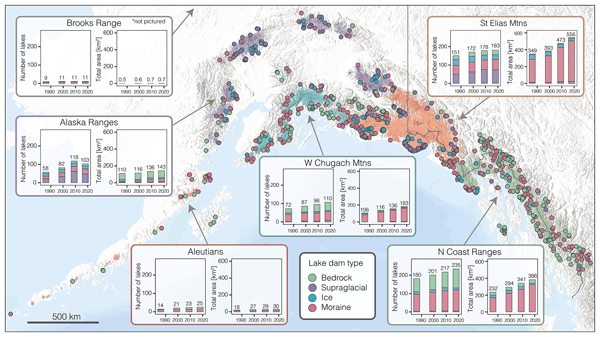
Brianna Rick, Daniel McGrath, William Armstrong, and Scott W. McCoy
The Cryosphere, 16, 297–314, https://doi.org/10.5194/tc-16-297-2022, https://doi.org/10.5194/tc-16-297-2022, 2022
Short summary
Short summary
Glacial lakes impact societies as both resources and hazards. Lakes form, grow, and drain as glaciers thin and retreat, and understanding lake evolution is a critical first step in assessing their hazard potential. We map glacial lakes in Alaska between 1984 and 2019. Overall, lakes grew in number and area, though lakes with different damming material (ice, moraine, bedrock) behaved differently. Namely, ice-dammed lakes decreased in number and area, a trend lost if dam type is not considered.
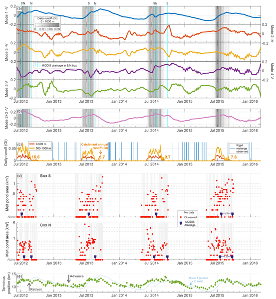
David W. Ashmore, Douglas W. F. Mair, Jonathan E. Higham, Stephen Brough, James M. Lea, and Isabel J. Nias
The Cryosphere, 16, 219–236, https://doi.org/10.5194/tc-16-219-2022, https://doi.org/10.5194/tc-16-219-2022, 2022
Short summary
Short summary
In this paper we explore the use of a transferrable and flexible statistical technique to try and untangle the multiple influences on marine-terminating glacier dynamics, as measured from space. We decompose a satellite-derived ice velocity record into ranked sets of static maps and temporal coefficients. We present evidence that the approach can identify velocity variability mainly driven by changes in terminus position and velocity variation mainly driven by subglacial hydrological processes.

Emma K. Fiedler, Matthew J. Martin, Ed Blockley, Davi Mignac, Nicolas Fournier, Andy Ridout, Andrew Shepherd, and Rachel Tilling
The Cryosphere, 16, 61–85, https://doi.org/10.5194/tc-16-61-2022, https://doi.org/10.5194/tc-16-61-2022, 2022
Short summary
Short summary
Sea ice thickness (SIT) observations derived from CryoSat-2 satellite measurements have been successfully used to initialise an ocean and sea ice forecasting model (FOAM). Other centres have previously used gridded and averaged SIT observations for this purpose, but we demonstrate here for the first time that SIT measurements along the satellite orbit track can be used. Validation of the resulting modelled SIT demonstrates improvements in the model performance compared to a control.
Zhongyang Hu, Peter Kuipers Munneke, Stef Lhermitte, Maaike Izeboud, and Michiel van den Broeke
The Cryosphere, 15, 5639–5658, https://doi.org/10.5194/tc-15-5639-2021, https://doi.org/10.5194/tc-15-5639-2021, 2021
Short summary
Short summary
Antarctica is shrinking, and part of the mass loss is caused by higher temperatures leading to more snowmelt. We use computer models to estimate the amount of melt, but this can be inaccurate – specifically in the areas with the most melt. This is because the model cannot account for small, darker areas like rocks or darker ice. Thus, we trained a computer using artificial intelligence and satellite images that showed these darker areas. The model computed an improved estimate of melt.
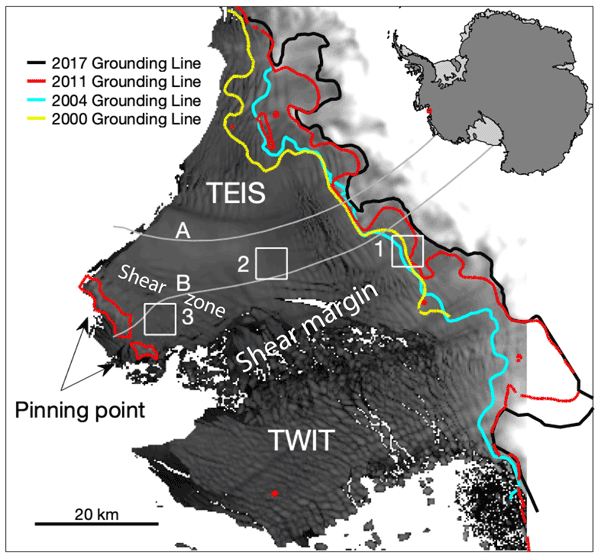
Karen E. Alley, Christian T. Wild, Adrian Luckman, Ted A. Scambos, Martin Truffer, Erin C. Pettit, Atsuhiro Muto, Bruce Wallin, Marin Klinger, Tyler Sutterley, Sarah F. Child, Cyrus Hulen, Jan T. M. Lenaerts, Michelle Maclennan, Eric Keenan, and Devon Dunmire
The Cryosphere, 15, 5187–5203, https://doi.org/10.5194/tc-15-5187-2021, https://doi.org/10.5194/tc-15-5187-2021, 2021
Short summary
Short summary
We present a 20-year, satellite-based record of velocity and thickness change on the Thwaites Eastern Ice Shelf (TEIS), the largest remaining floating extension of Thwaites Glacier (TG). TG holds the single greatest control on sea-level rise over the next few centuries, so it is important to understand changes on the TEIS, which controls much of TG's flow into the ocean. Our results suggest that the TEIS is progressively destabilizing and is likely to disintegrate over the next few decades.
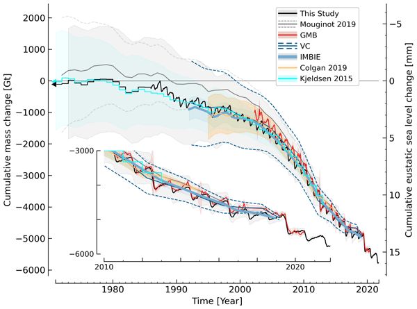
Kenneth D. Mankoff, Xavier Fettweis, Peter L. Langen, Martin Stendel, Kristian K. Kjeldsen, Nanna B. Karlsson, Brice Noël, Michiel R. van den Broeke, Anne Solgaard, William Colgan, Jason E. Box, Sebastian B. Simonsen, Michalea D. King, Andreas P. Ahlstrøm, Signe Bech Andersen, and Robert S. Fausto
Earth Syst. Sci. Data, 13, 5001–5025, https://doi.org/10.5194/essd-13-5001-2021, https://doi.org/10.5194/essd-13-5001-2021, 2021
Short summary
Short summary
We estimate the daily mass balance and its components (surface, marine, and basal mass balance) for the Greenland ice sheet. Our time series begins in 1840 and has annual resolution through 1985 and then daily from 1986 through next week. Results are operational (updated daily) and provided for the entire ice sheet or by commonly used regions or sectors. This is the first input–output mass balance estimate to include the basal mass balance.
Cited articles
Ashmore, D. W., Hubbard, B., Luckman, A., Kulessa, B., Bevan, S., Booth, A., Kuipers Munneke, P., O'Leary, M., Sevestre, H., and Holland, P. R.: Ice and firn heterogeneity within Larsen C Ice Shelf from borehole optical televiewing, J. Geophys. Res.-Earth, 122, 1139–1153, https://doi.org/10.1002/2016JF004047, 2017.
Barrand, N. E., Vaughan, D. G., Steiner, N., Tedesco, M., Kuipers Munneke, P., van den Broeke, M. R., and Hosking, J. S.: Trends in Antarctic Peninsula surface melting conditions from observations and regional climate modeling, J. Geophys. Res.-Earth, 118, 315–330, https://doi.org/10.1029/2012JF002559, 2013.
Berthier, E., Scambos, T. A., and Shuman, C. A.: Mass loss of Larsen B tributary glaciers (Antarctic Peninsula) unabated since 2012, Geophys. Res. Lett., 39, L13501, https://doi.org/10.1029/2012GL051755, 2012.
Bindschadler, R., Choi, H., Wichlacz, A., Bingham, R., Bohlander, J., Brunt, K., Corr, H., Drews, R., Fricker, H., Hall, M., Hindmarsh, R., Kohler, J., Padman, L., Rack, W., Rotschky, G., Urbini, S., Vornberger, P., and Young, N.: Getting around Antarctica: new high-resolution mappings of the grounded and freely-floating boundaries of the Antarctic ice sheet created for the International Polar Year, The Cryosphere, 5, 569–588, https://doi.org/10.5194/tc-5-569-2011, 2011.
Cape, M. R., Vernet, M., Skvarca, P., Marinsek, S., Scambos, T., and Domack, E.: Foehn winds link climate-driven warming to ice shelf evolution in Antarctica, J. Geophys. Res.-Atmos., 120, 11037–11057, https://doi.org/10.1002/2015JD023465, 2015.
Cook, A. J. and Vaughan, D. G.: Overview of areal changes of the ice shelves on the Antarctic Peninsula over the past 50 years, The Cryosphere, 4, 77–98, https://doi.org/10.5194/tc-4-77-2010, 2010.
De Angelis, H. and Skvarça, P.: Glacier surge after ice shelf collapse, Science, 299, 1560–1562, 2003.
DeConto, R. M. and Pollard, D.: Contribution of Antarctic to past and future sea-level rise, Nature, 531, 591–597, https://doi.org/10.1038/nature17145, 2016.
Dupont, T. K. and Alley, R. B.: Assessment of the importance of ice-shelf buttressing to ice-sheet flow, Geophys. Res. Lett., 32, L04503, https://doi.org/10.1029/2004GL022024, 2005.
Elvidge, A. D., Renfrew, I. A., King, J. C., Orr, A., Lachlan-Cope, T. A., Weeks, M., and Gray, S. L.: Föhn jets over the Larsen C Ice Shelf, Antarctica, Q. J. Roy. Meteor. Soc., 141, 698–713, https://doi.org/10.1002/qj.2382, 2014.
Gagliardini, O., Durand, G., Zwinger, T., Hindmarsh, R. C. A., and Meur, E. L.: Coupling of ice-shelf melting and buttressing is a key process in ice-sheet dynamics, Geophys. Res. Lett., 37, L14501, https://doi.org/10.1029/2010GL043334, 2010.
Haran, T., Bohlander, J., Scambos, T., Painter, T., and Fahnestock, M.: MODIS Mosaic of Antarctica 2008–2009 (MOA2009) Image Map, version 1, https://doi.org/10.7265/N5KP8037, available at: http://nsidc.org/data/NSIDC-0593 (last access: 11 October 2017), 2014.
Harig, C. and Simons, F. J.: Accelerated West Antarctic ice mass loss continues to outpace East Antarctic gains, Earth Planet. Sci. Lett., 415, 134–141, https://doi.org/10.1016/j.epsl.2015.01.029, 2015.
Herron, M. M. and Langway Jr., C. C.: Firn densification: an empirical model, J. Glaciol., 25, 373–385, 1980.
Holland, P. R., Corr, H. F. J., Pritchard, H. D., Vaughan, D. G., Arthern, R. J., Jenkins, A., and Tedesco, M.: The air content of Larsen Ice Shelf, Geophys. Res. Lett., 38, L10503, https://doi.org/10.1029/2011GL047245, 2011.
Hubbard, B., Roberson, S., Samyn, D., and Merton-Lyn, D.: Digital optical televiewing of ice boreholes, J. Glaciol., 54, 1–8, 2008.
Hubbard, B., Tison, J.-L., Philippe, M., Heene, B., Pattyn, F., Malone, T., and Freitag, J.: Ice shelf density reconstructed from optical televiewer borehole logging, Geophys. Res. Lett., 40, 5882–5887, https://doi.org/10.1002/2013GL058023, 2013.
Hubbard, B., Luckman, A., Ashmore, D., Bevan, S., Kulessa, B., Kuipers Munneke, P., Philippe, M., Jansen, D., Booth, A., Sevestre, H., Tison, J.-L., O'Leary, M., and Rutt, I.: Massive subsurface ice formed by refreezing of ice-shelf melt ponds, Nat. Comm., 7, 11897, https://doi.org/10.1038/ncomms11897, 2016.
Jansen, D., Luckman, A., Kulessa, B., Holland, P. R., and King, E. C.: Marine ice formation in a suture zone on the Larsen C ice shelf and its influence on ice shelf dynamics, J. Geophys. Res.-Earth, 118, 1628–1640, https://doi.org/10.1002/jgrf.20120, 2013.
King, J. C., Gadian, A., Kirchgaessner, A., Kuipers Munneke, P., Lachlan-Cope, T. A., Orr, A., Reijmer, C., van den Broeke, M. R., van Wessem, J. M., and Weeks, M.: Validation of the summertime surface energy budget of Larsen C Ice Shelf (Antarctica) as represented in three high-resolution atmospheric models, J. Geophys. Res.-Atmos., 120, 1335–1347, https://doi.org/10.1002/2014JD022604, 2015.
Koenig, L. S., Ivanoff, A., Alexander, P. M., MacGregor, J. A., Fettweis, X., Panzer, B., Paden, J. D., Forster, R. R., Das, I., McConnell, J. R., Tedesco, M., Leuschen, C., and Gogineni, P.: Annual Greenland accumulation rates (2009–2012) from airborne snow radar, The Cryosphere, 10, 1739–1752, https://doi.org/10.5194/tc-10-1739-2016, 2016.
Kovacs, A., Gow, A. J., and Morey, R. M.: The in-situ dielectric constant of polar firn revisited, Cold Reg. Sci. Technol., 23, 245–256, 1995.
Kuipers Munneke, P., van den Broeke, M. R., Lenaerts, J. T. M., Flanner, M. G., Gardner, A. S., and van de Berg, W. J.: A new albedo parameterization for use in climate models over the Antarctic ice sheet, J. Geophys. Res.-Atmos., 116, D05114, https://doi.org/10.1029/2010JD015113, 2011.
Kuipers Munneke, P., Picard, G., van den Broeke, M. R., Lenaerts, J. T. M., and van Meijgaard, E.: Insignificant change in Antarctic snowmelt volume since 1979, Geophys. Res. Lett., 39, L01501, https://doi.org/10.1029/2011GL050207, 2012.
Kuipers Munneke, P., Ligtenberg, S. R. M., van den Broeke, M. R., van Angelen, J. H., and Forster, R. R.: Explaining the presence of perennial liquid water bodies in the firn of the Greenland Ice Sheet, Geophys. Res. Lett., 41, 476–483, https://doi.org/10.1002/2013GL058389, 2014a.
Kuipers Munneke, P., Ligtenberg, S. R. M., van den Broeke, M. R., and Vaughan, D. G.: Firn air depletion as a precursor of Antarctic ice-shelf collapse, J. Glaciol., 60, 205–214, https://doi.org/10.3189/2014JoG13J183, 2014b.
Kuipers Munneke, P., McGrath, D., Medley, B., Van den Broeke, M. R., and Van Wessem, J. M.: Mean surface mass balance over Larsen C ice shelf, Antarctica (1979–2014), assimilated to in situ GPR and snow height data [Data set], U.S. Antarctic Program (USAP) Data Center, https://doi.org/10.15784/601056, 2017.
Kulessa, B., Jansen, D., Luckman, A. J., King, E. C., and Sammonds, P. R.: Marine ice regulates the future stability of a large Antarctic ice shelf, Nat. Comm., 5, 4707, https://doi.org/10.1038/ncomms4707, 2014.
Lenaerts, J. T. M., Brown, J., van den Broeke, M. R., Matsuoka, K., Drews, R., Callens, D., Philippe, M., Gorodetskaya, I. V., van Meijgaard, E., Reijmer, C. H., Pattyn, F., and van Lipzig, N. P. M.: High variability of climate and surface mass balance induced by Antarctic ice rises, J. Glaciol., 60, 1–10, https://doi.org/10.3189/2014JoG14J040, 2014.
Lenaerts, J. T. M., Vizcaino, M., Fyke, J., van Kampenhout, L., and van den Broeke, M. R.: Present-day and future Antarctic ice sheet climate and surface mass balance in the Community Earth System Model, Clim. Dynam., 47, 1367–1381, https://doi.org/10.1007/s00382-015-2907-4, 2016.
Luckman, A., Jansen, D., Kulessa, B., King, E. C., Sammonds, P., and Benn, D. I.: Basal crevasses in Larsen C Ice Shelf and implications for their global abundance, The Cryosphere, 6, 113–123, https://doi.org/10.5194/tc-6-113-2012, 2012.
Luckman, A., Elvidge, A., Jansen, D., Kulessa, B., Kuipers Munneke, P., King, J., and Barrand, N. E.: Surface melt and ponding on Larsen C Ice Shelf and the impact of föhn winds, Antarct. Sci., 26, 625–635, https://doi.org/10.1017/S0954102014000339, 2014.
MacAyeal, D. R. and Sergienko, O. V.: The flexural dynamics of melting ice shelves, Ann. Glaciol., 54, 1–10, https://doi.org/10.3189/2013AoG63A256, 2013.
Marshall, G. J., Orr, A., van Lipzig, N., and King, J. C.: The impact of a changing Southern Hemisphere AnnularMode on Antarctic Peninsula summer temperatures, J. Climate, 19, 5399–5405, https://doi.org/10.1175/Jcli3844.1, 2006.
McGrath, D., Steffen, K., Scambos, T. A., Rajaram, H., Casassa, G., and Rodriguez Lagos, J. L.: Basal crevasses and associated surface crevassing on the Larsen C ice shelf, Antarctica, and their role in ice-shelf instability, Ann. Glaciol., 58, 10–18, https://doi.org/10.3189/2012AoG60A005, 2012.
McGrath, D., Steffen, K., Holland, P. R., Scambos, T., Rajaram, H., Abdalati, W., and Rignot, E.: The structure and effect of suture zones in the Larsen C Ice Shelf,, J. Geophys. Res.-Earth, 119, 588–602, https://doi.org/10.1002/2013JF002935, 2014.
Medley, B., Joughin, I., Das, S. B., Steig, E. J., Conway, H., Gogineni, S., Criscitiello, A. S., McConnell, J. R., Smith, B. E., van den Broeke, M. R., Lenaerts, J. T. M., Bromwich, D. H., and Nicolas, J. P.: Airborne-radar and ice-core observations of annual snow accumulation over Thwaites Glacier, West Antarctica confirm the spatiotemporal variability of global and regional atmospheric models, Geophys. Res. Lett., 40, 3649–3654, https://doi.org/10.1002/grl.50706, 2013.
Medley, B., Ligtenberg, S. R. M., Joughin, I., van den Broeke, M. R., Gogineni, S., and Nowicki, S.: Antarctic firn compaction rates from repeat-track airborne radar data: I. Methods, Ann. Glaciol., 56, 155–166, https://doi.org/10.3189/2015AoG70A203, 2015.
Morris, E. M.: A theoretical analysis of the neutron-scattering method for measuring snow and ice density, J. Geophys. Res.-Earth, 113, F03019, https://doi.org/10.1029/2007JF000962, 2008.
Morris, E. M. and Vaughan, D. G.: Spatial and temporal variation of surface temperature on the Antarctic Peninsula and the limit of viability of ice shelves, vol. 79, 61–68, AGU, Washington, DC, https://doi.org/10.1029/AR079p0061, 2003.
Mulvaney, R. and Wolff, E. W.: Evidence for winter/spring denitrification of the stratosphere in the nitrate record of Antarctic firn cores, J. Geophys. Res., 98, 5213–5220, 1993.
Parish, T. R.: The influence of the Antarctic Peninsula on the wind field over the western Weddell Sea, J. Geophys. Res.-Oceans, 88, 2684–2692, https://doi.org/10.1029/JC088iC04p02684, 1983.
Peel, D. A. and Clausen, H. B.: Oxygen-isotope and total beta-radioactivity measurements on 10 m ice cores from the Antarctic Peninsula, J. Glaciol., 98, 43–55, 1982.
Powers, J. G., Manning, K. W., Bromwich, D. H., Cassano, J. J., and Cayette, A. M.: A decade of Antarctic science support through AMPS, B. Am. Meteorol. Soc., 93, 1699–1712, https://doi.org/10.1175/bams-d-11-00186.1, 2012.
Rott, H., Rack, W., Nagler, T., and Skvarça, P.: Climatically induced retreat and collapse of the northern Larsen Ice Shelf, Antarctic Peninsula, Ann. Glaciol., 27, 86–92, 1998.
Scambos, T. A., Hulbe, C., Fahnestock, M., and Bohlander, J.: The link between climate warming and break-up of ice shelves in the Antarctic Peninsula, J. Glaciol., 46, 516–530, 2000.
Scambos, T. A., Hulbe, C., and Fahnestock, M.: Climate-induced ice shelf disintegration in the Antarctic Peninsula, in: Antarctic Peninsula Climate Variability: Historical and Paleoenvironmental Perspectives, edited by: Domack, E., vol. 79 of Antarct. Res. Ser., 79–92, AGU, Washington, DC, 2003.
Scambos, T. A., Bohlander, J. A., Shuman, C. A., and Skvarça, P.: Glacier acceleration and thinning after ice shelf collapse in the Larsen B embayment, Antarctica, Geophys. Res. Lett., 31, L18402, https://doi.org/10.1029/2004GL020670, 2004.
Scambos, T. A., Haran, T., Fahnestock, M., Painter, T., and Bohlander, J.: MODIS-based Mosaic of Antarctica(MOA) data sets: continent-wide surface morphology and snow grain size, Rem. Sens. Environ., 111, 242–257, https://doi.org/10.1016/j.rse.2006.12.020, 2007.
Shepherd, A., Ivins, E. R., Guero, A., and the IMBIE Project Group: A reconciled estimate if ice-sheet mass balance, Science, 338, 1183–1189, https://doi.org/10.1126/science.1228102, 2012.
Trusel, L. D., Frey, K. E., Das, S. B., Kuipers Munneke, P., and van den Broeke, M. R.: Satellite-based estimates of Antarctic surface meltwater fluxes, Geophys. Res. Lett., 40, 6148–6153, https://doi.org/10.1002/2013GL058138, 2013.
Turner, J., Leonard, S., Lachlan-Cope, T. A., and Marshall, G. J.: Understanding Antarctic Peninsula precipitation distribution and variability using a numerical weather prediction model, Ann. Glaciol., 27, 591–596, 1998a.
Turner, J., Marshall, G. J., and Lachlan-Cope, T. A.: Analysis of synoptic-scale low pressure systems within the Antarctic Peninsula sector of the circumpolar trough, Int. J. Climatol., 18, 253–280, 1998b.
Turner, J., Lachlan-Cope, T. A., Marshall, G. J., Morris, E. M., Mulvaney, R., and Winter, W.: Spatial variability of Antarctic Peninsula net surface mass balance, J. Geophys. Res.-Atmos., 107, 4173, https://doi.org/10.1029/2001JD000755, 2002.
Turner, J., Barrand, N. E., Bracegirdle, T. J., Convey, P., Hodgson, D. A., Jarvis, M., Jenkins, A., Marshall, G., Meredith, M. P., Roscoe, H., Shanklin, J., French, J., Goosse, H., Guglielmin, M., Gutt, J., Jacobs, S., Kennicutt, M. C., Masson-Delmotte, V., Mayewsky, P., Navarro, F., Robinson, S., Scambos, T., Sparrow, M., Summerhayes, C., Speer, K., and Klepikov, A.: Antarctic climate change and the environment: an update, Polar Record, 50, 237–259, https://doi.org/10.1017/S0032247413000296, 2014.
Turner, J., Lu, H., White, I., King, J. C., Phillips, T., Hosking, J. S., Bracegirdle, T. J., Marshall, G. J., Mulvaney, R., and Deb, P.: Absence of 21st century warming on Antarctic Peninsula consistent with natural variability, Nature, 535, 411–415, https://doi.org/10.1038/nature18645, 2016.
Van der Veen, C. J.: Fracture propagation as means of rapidly transferring surface meltwater to the base of glaciers, Geophys. Res. Lett., 34, L01501, https://doi.org/10.1029/2006GL028385, 2007.
van Wessem, J. M., Ligtenberg, S. R. M., Reijmer, C. H., van de Berg, W. J., van den Broeke, M. R., Barrand, N. E., Thomas, E. R., Turner, J., Wuite, J., Scambos, T. A., and van Meijgaard, E.: The modelled surface mass balance of the Antarctic Peninsula at 5.5 km horizontal resolution, The Cryosphere, 10, 271–285, https://doi.org/10.5194/tc-10-271-2016, 2016.
Short summary
How much snow falls on the Larsen C ice shelf? This is a relevant question, because this ice shelf might collapse sometime this century. To know if and when this could happen, we found out how much snow falls on its surface. This was difficult, because there are only very few measurements. Here, we used data from automatic weather stations, sled-pulled radars, and a climate model to find that melting the annual snowfall produces about 20 cm of water in the NE and over 70 cm in the SW.
How much snow falls on the Larsen C ice shelf? This is a relevant question, because this ice...


