the Creative Commons Attribution 4.0 License.
the Creative Commons Attribution 4.0 License.
 | 14 Feb 2024
Brief communication: An ice-debris avalanche in the Nupchu Valley, Kanchenjunga Conservation Area, eastern Nepal
Alton C. Byers
Marcelo Somos-Valenzuela
Dan H. Shugar
Daniel McGrath
Mohan B. Chand
Ram Avtar
Beginning in December 2020, a series of small to medium, torrent-like pulses commenced upon a historic debris cone located within the Nupchu Valley, Kanchenjunga Conservation Area (KCA), Nepal. Sometime between 16 and 21 August 2022 a comparatively large ice-debris avalanche event occurred, covering an area of 0.6 km2 with a total estimated volume of order 106 m3. The area of the debris cone left by the August 2022 event increased the historic debris cone area by 0.2 km2 (total area 0.6 km2). Although no human or livestock deaths occurred, the increase in torrent-like pulses of debris upon this historic debris cone since 2020 exemplifies a style of mass movement that may become increasingly common as air temperatures rise in the region. Although the magnitude of this event was small compared to events like the 2021 Chamoli avalanche, the widespread distribution and frequency of comparable events present a substantial, and potentially increasing, hazard across High Mountain Asia.
- Article
(5170 KB) - Full-text XML
- Companion paper
- BibTeX
- EndNote


Large-magnitude but low-frequency events in high mountains can include a variety of familiar and poorly understood cryospheric processes, including glacial lake outburst floods (GLOFs) (Lamsal et al., 2016); snow, ice, or rock avalanches (Shugar et al., 2021); landslide-induced avalanches and floods (Byers et al., 2019); englacial conduit floods (Rounce et al., 2017); and others (see Byers et al., 2022). Today, enhanced communications and remote sensing technologies enable rapid identification and location of such events, often within hours of their occurrence. Many, however, remain unreported because of their remoteness, inaccessibility, poor communications, and/or absence of people (see Byers et al., 2020). In this Brief communication, we report on a large ice-debris avalanche that occurred sometime between 16 and 21 August 2022 in the Kanchenjunga Conservation Area (KCA), eastern Nepal. The event is noteworthy not only because of its probable linkages to climate change impacts in the region, but also because local residents were unaware of its occurrence, as were the government of Nepal and climate change research entities in Kathmandu. Here we briefly document the event and describe its present and future implications for local communities, scientists, and governments.
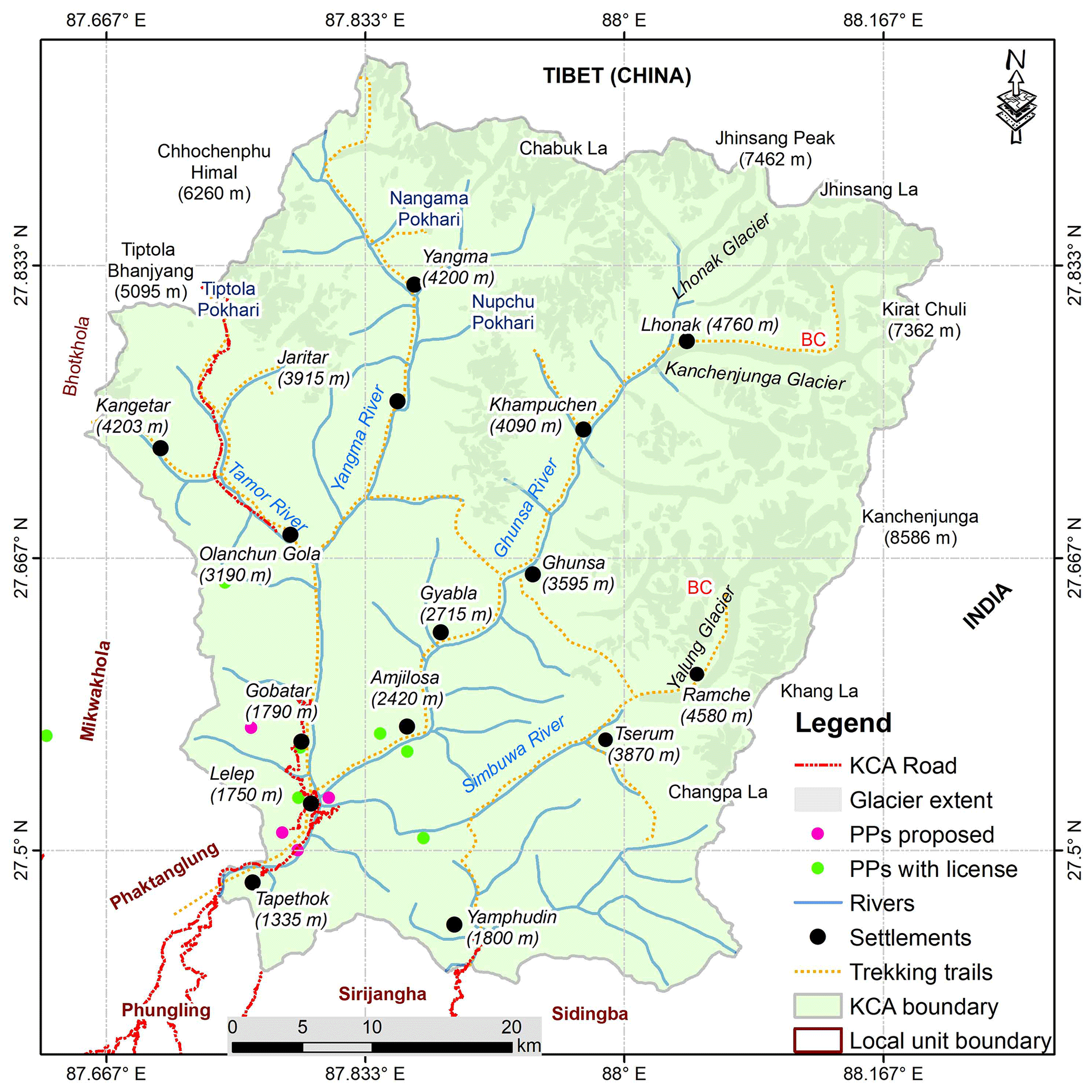
Figure 1Kanchenjunga Conservation Area and location of the Nupchu ice-debris avalanche.
The KCA is a 2035 km2 protected area established in 1997 by the Nepalese Department of National Parks and Wildlife Conservation, with management responsibility handed over to local communities in 2006 (WWF, 2018) (Fig. 1). It is home to a range of ethnic groups of primarily Tibeto-Burman origin that include Limbu, Rai, Tamang, Gurung, Magar, Chhetri, and Sherpa (Thapa, 2009). Livelihoods were traditionally based upon agriculture, livestock raising, and trade with Tibet, but globalization, outmigration, and new road construction over the past 15 years have rapidly changed the character of both the social and environmental landscapes. The South Asian monsoon dominates weather patterns, with most rainfall falling between June and September (Kandel et al., 2019).
Based upon an analysis of 1962–2000 satellite imagery, valley and mountain glaciers in the KCA cover approximately 488±29 km2 and exhibit an overall negative glacier surface area loss of 0.5±0.2 % yr−1 (Racoviteanu et al., 2015). Valley glaciers are largely debris-covered and have been receding since the most recent maximum during the Little Ice Age. Hooker (1854), for example, wrote in 1849 of observing glacial moraines that provided proof “… of glaciers having once descended to from 8,000 to 10,000 feet in every Sikkim and east Nepal valley…” (Hooker, 1854, p. 166). The British alpinist Freshfield (1903, p. 236) writes of the “glacial shrinkage” he encountered in the Lhonak region in 1899 as well as throughout both the Nepal and Sikkim sides of the Kanchenjunga massif. Although the Kanchenjunga region received some of the earliest study, exploration, and mountaineering expeditions in Nepal by outsiders (Thapa, 2009), relatively little glacier and cryospheric hazard research has been conducted to date. For example, until 2019 only one GLOF event was on record for the region (Watanabe et al., 1998; ICIMOD, 2011), although subsequent research revealed that at least seven others had occurred since 1921 (Byers et al., 2020). The Nupchu Valley, where the ice-debris avalanche of concern occurred, is used seasonally for yak herding, potato farming, and tourism, with four operational tourist lodges in the village of Kampuchen as of the fall of 2022 (Fig. 1).
Field-based observations and assessments of Nupchu Pokhari (glacial lake), other nearby lakes, and the ice-debris avalanche were conducted between 1 and 20 September 2022. The methods included GPS-based route mapping, photography of avalanche features, oral testimony, and literature reviews. Historic (declassified KH-9 Hexagon satellite imagery; see Maurer et al., 2019; Dehecq et al., 2020) and recent (Planet Dove and SuperDove) satellite imagery revealed the sequence of avalanche and debris flow events between 1975 and 2023 (Fig. 2). Numerical simulations of the avalanche were conducted using R.Avaflow version 3 (Mergili and Pudasaini, 2014–2023; Mergili et al., 2017), state-of-the-art software that has been used globally to study ice and rock avalanche events (Zhang et al., 2022). Numerical simulations were used to provide upper-limit volume estimation of the avalanche and were constrained by field observations. We used the parameters from Zhang et al. (2022) to produce a single-phase model scenario for three different volumes: 1, 2.5, and 5×10⁶ m3. For calibration, we modified the internal friction angle of the mixture to match the extension of the debris left by the event. For the terrain elevation, two DEMs were used: the ALOS PALSAR Radiometric Terrain Corrected high-resolution 12.5 m DEM (AP_13152_FBD_F0540_RT1) (ASF DAAC, 2014) and the High Mountain Asia 8 m resolution DEM (Shean, 2017) that was void-filled using the Elevation Void Fill function in ArcGIS 10.8.
The investigation of the Nupchu Valley was initiated by local concerns about Nupchu Pokhari (27.790708∘ N, 87.934275∘ E) as being one of the most dangerous glacial lakes in terms of a potential GLOF (Fig. 1). Periodic, smaller floods from the upper Nupchu Valley were reported and assumed locally to have originated in the Nupchu Pokhari, although no supporting evidence was available. Our field reconnaissance results of Nupchu Pokhari on 12 September 2022, however, suggested that the lake posed a moderate risk of flooding largely based upon the absence of overhanging ice and other potential flood triggers. This assessment corroborates the findings of Rounce et al. (2017), which concluded that the 0.129 km2 Nupchu Pokhari presented only a moderate risk of flooding because of (a) no apparent growth between 2000 and 2015, (b) an absence of avalanche pathways into the lake (i.e., in line with the direction of the lake and its outflow), and (c) an absence of landslide pathways entering the lake.
The August 2022 ice-debris avalanche event was unexpected. Field staff had conducted a reconnaissance of the valley below Nupchu Pokhari in early August 2022 to check out potential camping sites, at which time the upper valley was primarily pastureland. When the field team and Alton C. Byers returned in early September, the original path was blocked by massive ice-debris avalanche material (27.774328∘ N, 87.941064∘ E) that had clearly occurred at some point in the interim (Fig. 2). Our team and dzopkio (yak–cattle crossbreeds used as pack animals) were nevertheless able to climb up and over the avalanche debris to the upper Nupchu Valley, but at the time the source and triggers related to the event remained unknown.
The original historic debris cone was found to have covered an area of 0.402 km2 that had been relatively stable for at least 45 years, based upon the oldest satellite imagery available (i.e., 1975) (Dehecq et al., 2020) (Fig. 2a). Time series satellite images revealed the periodic occurrence of surficial debris flows upon this original deposition. That is, beginning in 2020, a series of small to medium, torrent-like pulses commenced (Fig. 2c–g), culminating in the relatively large event that occurred sometime between 16 and 21 August 2022 (Fig. 2h). The area of the debris cone left by the August 2022 event increased the original area covered by 0.2 km2 (total area 0.6 km2). Of the three different volume estimates tested (1, 2.5, and 5 ×10⁶ m3) using two DEMs and R.Avaflow, an avalanche volume of 1×10⁶ m3 using an ALOS PALSAR RTC DEM most consistently matched the extent (red line) and depth of the new debris cone deposited as determined by our field observations (Fig. 3).
Our team was unable to locate the event on any seismographs, most likely related to the absence of instrumentation in this part of the eastern Himalaya. Based upon direct field observations as well as satellite imagery, the avalanche had clearly blocked and temporarily dammed the water from the Nupchu Khola (river) at its onset, which was nevertheless able to cut down through the ice and sediment deposited to form a steep canyon estimated at >10 m depth. The presence of shrubs (e.g., J. indica) fully stripped of their bark was testimony to the high velocities of the floodwater and meltwater produced by frictional forces during the event, a phenomenon reported for other rockfall-induced landslides in Nepal (Byers et al., 2019).
Interestingly, individuals in the community of Kampuchen, only 5 km downstream of the event, were unaware of the avalanche. Yak herds had already returned from the high pastures to the village by early August, the community was busy harvesting potatoes and preparing for the fall tourist season, and no obvious changes in the Nupchu Khola had been observed (e.g., Kargel, 2014, for a description of the changes in the Seti Kosi prior to the catastrophic flooding of 5 May 2012). Thus, authorities in Taplejung and Kathmandu were also unaware of the event as of September 2022, which is typical of many large-scale cryospheric events in remote regions of the Himalaya (e.g., Byers et al., 2022).
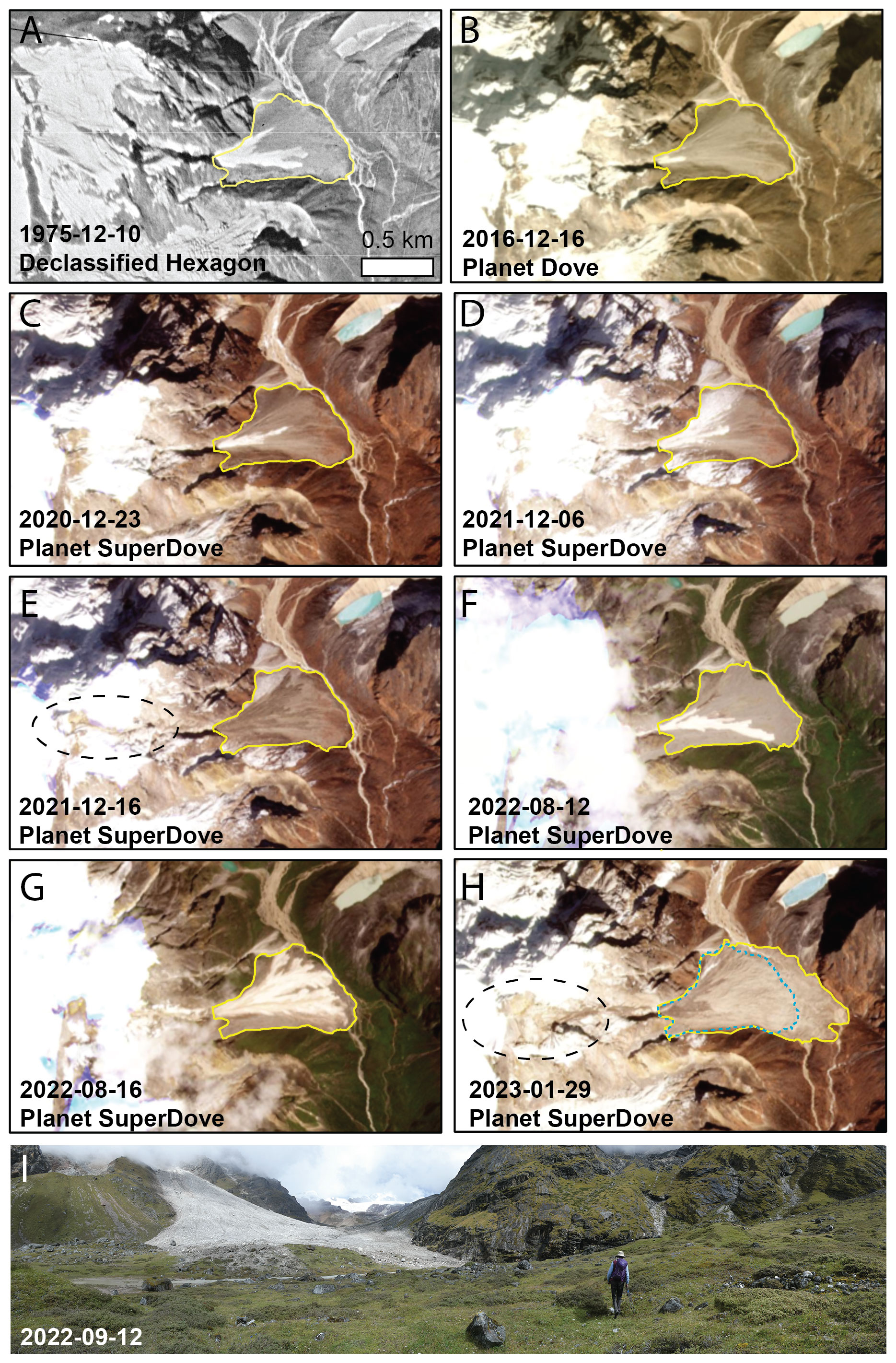
Figure 2Time series satellite images showing the periodic occurrence of surficial debris flows upon the original deposition. These appear to have accelerated in both frequency in magnitude beginning several years ago, leading up to the main event that occurred between 16 and 21 August 2022. The blue dashed outline in panel (h) is the 1975 outline of the debris cone, while the dashed black circle identifies the failure zone. The photograph at the bottom provides an oblique view of the ice-debris avalanche about 3 weeks after it occurred (photograph by Alton C. Byers). Panel (h) shows an image from early 2023, as imagery from immediately after the ice avalanche in mid-August 2022 was partially obscured by clouds (KH-9 imagery courtesy of USGS; Planet Dove and SuperDove imagery courtesy of Planet Lab PBC).
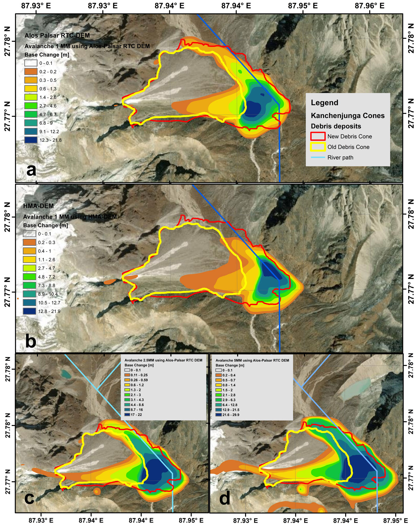
Figure 3Base change modeled with R.Avaflow for three different avalanche volumes: (a) 1×10⁶ m3 using an ALOS PALSAR RTC DEM, (b) 1×10⁶ m3 using the void-filled HMA-DEM, (c) 2.5×10⁶ m3 using an ALOS PALSAR RTC DEM, and (d) 5×10⁶ m3 using an ALOS PALSAR RTC DEM. Of the three estimates and two DEMs, 1×10⁶ m3 using an ALOS PALSAR RTC DEM most consistently matched the extent and depth of the new debris cone deposited in August 2022 (red line; the yellow line represents the extent of the historic debris cone).
Still, the acceleration of torrent-like pulses of debris upon the historic debris cone since 2020 suggests that these events may be linked to contemporary warming trends, similar to those that may have triggered larger-scale mass wasting events elsewhere in the Himalaya (e.g., Shugar et al., 2021; Kääb et al., 2021; Taylor et al., 2023). The frequency of such ice-debris flow events within the KCA region, and more broadly across the Himalaya, is unknown. However, with projections of continued warming in these regions (e.g., Lalande et al., 2021), a more systematic approach to determining their historic frequency, as well as a better understanding of their triggers, is warranted. After further evaluation, vulnerable villages, such as Kampuchen, may wish to consider the installation of preventative floodwater diversion mechanisms, such as the rock-filled gabion walls currently protecting tourist lodges in the Mt. Everest region (e.g., Rounce et al., 2017; Byers et al., 2022) using participatory processes as outlined in Watanabe et al. (2016).
Beginning in 2020, a series of small to medium, torrent-like pulses commenced upon a historic debris cone located approximately 2 km down-valley from the Nupchu glacial lake, culminating in a relatively large avalanche event that occurred sometime between 16 and 21 August 2022. The August 2022 event deposited debris with an area of 0.6 km2 and an estimated volume on the order of 106 m3. No fatalities from the event occurred because of the absence of humans and livestock in the vicinity when the event occurred. Likewise, no impoundment of the Nupchu Khola and formation of a potentially dangerous backwater lake occurred as a result of debris blockage, although such scenarios happen routinely in high mountain environments.
The improvement of remote-area event-reporting mechanisms, especially to authorities in the capital, Kathmandu, could help with the development of hazard mitigation technologies and responses. Likewise, more systematic monitoring of cryospheric events by scientists, using remote sensing platforms and hazard mapping tools, could help with the development of more effective early warning systems for vulnerable communities, livestock, and adventure tourists. Ultimately, this could lead to a minimization of losses and damage due to multi-hazard events.
Declassified KH-9 Hexagon satellite imagery is available at https://earthexplorer.usgs.gov/ (USGS, 2023). Planet Dove and SuperDove satellite imagery is available at https://www.planet.com/explorer/ (Planet Labs, 2023). The ALOS PALSAR Radiometric Terrain Corrected high-resolution DEM AP_13152_FBD_F0540_RT1 is available at https://search.asf.alaska.edu/ (NASA, 2024). The High Mountain Asia 8 m DEM is available at https://nsidc.org/data/hma_dem8m_ct/versions/1#anchor-1 (NSIDC, 2023).
ACB conceived the study and wrote the original narrative, with contributions from MSV, DHS, DM, MBC, and RA. MBC created Fig. 1, DHS and RA created Fig. 2, and MSV created Fig. 3. MSV conducted the numerical simulations of avalanche volumes shown in Fig. 3. All the authors revised and contributed to the final manuscript.
The contact author has declared that none of the authors has any competing interests.
Publisher's note: Copernicus Publications remains neutral with regard to jurisdictional claims made in the text, published maps, institutional affiliations, or any other geographical representation in this paper. While Copernicus Publications makes every effort to include appropriate place names, the final responsibility lies with the authors.
The Department of National Parks and Wildlife Conservation, Kanchenjunga Conservation Area, and the Department of Geography at Tribhuvan University are thanked for their interest in and support of the project.
Alton C. Byers was supported by the Fulbright Nepal Scholar Program during his 6-month field study of contemporary impacts on alpine ecosystems in the Kanchenjunga Conservation Area, eastern Nepal. Support for Marcelo Somos-Valenzuela during the preparation of this paper was provided by the Chilean Science Council (ANID) through the Program of International Cooperation (grant no. PII180008). Support for Dan H. Shugar was provided by the Natural Sciences and Engineering Research Council of Canada (grant no. DG-2020-04207) and Alberta Innovates. Support for Daniel McGrath was provided by NASA (grant no. 80NSSC20K1343).
This paper was edited by Chris Derksen and reviewed by two anonymous referees.
ASF DAAC: ALOS PALSAR Radiometric Terrain Corrected high res, Includes Material © JAXA/METI 2008, https://asf.alaska.edu/data-sets/sar-data-sets/alos-palsar/alos-palsar-how-to-cite/ (last access: 10 April 2023), 2014.
Byers, A. C., Rounce, D. R., Shugar, D. H., and Regmi, D.: A rockfall-induced glacial lake outburst flood, upper Barun valley, Nepal. Landslides, 16, 533, https://doi.org/10.1007/s10346-018-1079-9, 2019.
Byers, A. C., Chand, M. B., Lala, J., Shrestha, M., Byers, E. A., and Watanabe, T.: Reconstructing the history of glacial lake outburst floods (GLOF) in the Kanchenjunga Conservation Area, east Nepal: an interdisciplinary approach, Sustainability, 12, 5407, https://doi.org/10.3390/su12135407, 2020.
Byers, A. C., Shugar, D., Chand, M., Portocarrero, C., Shrestha, M., Rounce, D., and Watanabe, T.: Three recent and lesser-known glacier-related flood mechanisms in high mountain environments, Mount. Res. Develop., 42, A12–A22, https://doi.org/10.1659/MRD-JOURNAL-D-21-00045.1, 2022.
Dehecq, A., Gardner, A. S., Alexandrov, O., McMichael, S., Hugonnet, R., Shean, D., and Marty, M.: Automated processing of declassified KH-9 Hexagon satellite images for global elevation change analysis since the 1970s, Front. Earth Sci., 8, https://doi.org/10.3389/feart.2020.566802, 2020.
Freshfield, D. W.: Round Kangchenjunga: A Narrative of Mountain Travel and Exploration (historic reprint), http://www.forgottenbooks.com (last access: August 2023), 1903.
Hooker, J. D.: Himalayan Journals, vol. 1, The Perfect Library, Orlando, historic reprint, 2015, 268 pp., ISBN 10-1511976020, 1854.
International Centre for Integrated Mountain Development (ICIMOD): Glacial Lakes and Glacial Lake Outburst Floods in Nepal. International Centre for Integrated Mountain Development (ICIMOD), Report, Kathmandu, ICIMOD, 99 pp., 2011.
Kääb, A., Jacquemart, M., Gilbert, A., Leinss, S., Girod, L., Huggel, C., Falaschi, D., Ugalde, F., Petrakov, D., Chernomorets, S., Dokukin, M., Paul, F., Gascoin, S., Berthier, E., and Kargel, J. S.: Sudden large-volume detachments of low-angle mountain glaciers – more frequent than thought?, The Cryosphere, 15, 1751–1785, https://doi.org/10.5194/tc-15-1751-2021, 2021.
Kandel, P., Chettri, N., Chaudhary, R. P., Badola, H. M., Gaira, K. S., Wangchuk, S., Bidha, N., Uprety, Y., and Sharma, E.: Plant Diversity of the Kangchenjunga Landscape, Eastern Himalayas, Plant Diversity, 41, 153–165, https://doi.org/10.1016/j.pld.2019.04.006, 2019.
Kargel, J.: One scientist's search for the causes of the deadly Seti River flash flood. Earth Observatory, https://earthobservatory.nasa.gov/blogs/fromthefield/2014/01/24/setiriverclues/ (last access: 15 December 2022), 24 January 2014.
Lalande, M., Ménégoz, M., Krinner, G., Naegeli, K., and Wunderle, S.: Climate change in the High Mountain Asia in CMIP6, Earth Syst. Dynam., 12, 1061–1098, https://doi.org/10.5194/esd-12-1061-2021, 2021.
Lamsal, D., Sawagaki, T., Watanabe, T., and Byers, A. C.: Assessment of glacial lake development and prospects of outburst susceptibility: Chamlang South Glacier, eastern Nepal Himalaya, Geomatics, Natural Hazards and Risk, 7, 403–423, https://doi.org/10.1080/19475705.2014.931306, 2016.
Maurer, J. M., Schaeffer, J. M., Rupper, S., and Corley, A.: Acceleration of ice loss across the Himalayas over the past 40 years, Sci. Adv., 5, eaav7266, https://doi.org/10.1126/sciadv.aav7266, 2019.
Mergili, M. and Pudasaini, S. P.: r.avaflow – The Mass Flow Simulation Tool, https://www.avaflow.org (last access: 8 April 2023), 2014–2023.
Mergili, M., Fischer, J.-T., Krenn, J., and Pudasaini, S. P.: r.avaflow v1, an advanced open-source computational framework for the propagation and interaction of two-phase mass flows, Geosci. Model Dev., 10, 553–569, https://doi.org/10.5194/gmd-10-553-2017, 2017.
NASA: Earth Data, NASA [data set], https://search.asf.alaska.edu/ (last access: 10 April 2023), 2024.
NSIDC: Data Access & Tools, NASA [data set], https://nsidc.org/data/hma_dem8m_ct/versions/1#anchor-1 (last access: 20 September 2023), 2023.
Planet Labs: Daily Global Satellite Imagery Explorer, Planet Labs [data set], https://www.planet.com/explorer/, last access: 1 February 2023.
Racoviteanu, A. E., Arnaud, Y., Williams, M. W., and Manley, W. F.: Spatial patterns in glacier characteristics and area changes from 1962 to 2006 in the Kanchenjunga–Sikkim area, eastern Himalaya, The Cryosphere, 9, 505–523, https://doi.org/10.5194/tc-9-505-2015, 2015.
Rounce, D. R., Byers, A. C., Byers, E. A., and McKinney, D. C.: Brief communication: Observations of a glacier outburst flood from Lhotse Glacier, Everest area, Nepal, The Cryosphere, 11, 443–449, https://doi.org/10.5194/tc-11-443-2017, 2017.
Shean, D.: High Mountain Asia 8-meter DEMs Derived from Cross-track Optical Imagery, Boulder, CO, NASA NSIDC DAAC: NASA National Snow and Ice Data Center Distributed Active Archive Center [data set], https://doi.org/10.5067/0MCWJJH5ABYO (last access: 20 July 2023), 2017.
Shugar, D. H., Jacquemart, M., Shean, D., et al.: A massive rock and ice avalanche caused the 2021 disaster at Chamoli, Indian Himalaya, Science, 373, 300–306, https://doi.org/10.1126/science.abh4455, 2021.
Taylor, C., Robinson, T. R., Dunning, S., Carr, R., and Westoby, M.: Glacial lake outburst floods threaten millions globally, Nat. Commun., 14, 487, https://doi.org/10.1038/s41467-023-36033-x, 2023.
Thapa, R.: Kanchenjunga: The Unique Gift of Nature, Kanchan Printing Press, Kathmandu, 272 pp., 2009.
USGS: Earth Explorer, USGS [data set], https://earthexplorer.usgs.gov/ (last access: 25 January 2023), 2023.
Watanabe, T., Khanal, N. R., and Gautam, M. P.: The Nangama glacial lake outburst flood occurred on 23 June 1980 in the Kanchanjunga area, eastern Nepal, Ann. Hokkaido Geogr. Soc., 72, 13–20, https://doi.org/10.14917/hgs1959.1998.13, 1998.
Watanabe, T., Byers, A. C., Somos-Valenzuela, M. A., and McKinney, D. C.: The need for community involvement in glacial lake field research: the case of Imja Glacial Lake, Khumbu, Nepal Himalaya, Chapter 13, in:Climate Change, Glacier Response, and Vegetation Dynamics in the Himalaya: Contributions Toward Future Earth Initiatives, edited by: Singh, R. B., Schickhoff, U., and Mal, S., Springer International Publishing Switzerland, 235–250, https://doi.org/10.1007/978-3-319-28977-9_13, 2016.
WWF: Kanchenjunga Conservation Area Project 1998–2017: A Retrospective Report, Report, WWF, Kathmandu, 2018.
Zhang, T., Wang, W., Shen, Z., Zhan, N., Wang, Z., and An, B: Understanding the 2004 Glacier Detachment in the Amney Machen Mountains, Northeastern Tibetan Plateau, Via Multi-Phase Modeling, Landslides, 2, 315–330, https://doi.org/10.1007/s10346-022-01989-2, 2022.