
Articles | Volume 12, issue 2
https://doi.org/10.5194/tc-12-521-2018
© Author(s) 2018. This work is distributed under
the Creative Commons Attribution 3.0 License.
the Creative Commons Attribution 3.0 License.
https://doi.org/10.5194/tc-12-521-2018
© Author(s) 2018. This work is distributed under
the Creative Commons Attribution 3.0 License.
the Creative Commons Attribution 3.0 License.
Research article
| 
13 Feb 2018
Research article |
| 13 Feb 2018
Increased West Antarctic and unchanged East Antarctic ice discharge over the last 7 years
Alex S. Gardner
CORRESPONDING AUTHOR
Jet Propulsion Laboratory, California Institute of Technology, Pasadena, CA 91109, USA
Geir Moholdt
Norwegian Polar Institute, Fram Centre, 9296 Tromsø, Norway
Ted Scambos
National Snow and Ice Data Center (NSIDC), University of Colorado at Boulder, Boulder, CO 80303, USA
Mark Fahnstock
Geophysical Institute, University of Alaska Fairbanks, Fairbanks, AK 99775, USA
Stefan Ligtenberg
Institute for Marine and Atmospheric research Utrecht (IMAU), Utrecht University, Utrecht, the Netherlands
Michiel van den Broeke
Institute for Marine and Atmospheric research Utrecht (IMAU), Utrecht University, Utrecht, the Netherlands
Johan Nilsson
Jet Propulsion Laboratory, California Institute of Technology, Pasadena, CA 91109, USA
Related authors
David N. Wiese, Johan Nilsson, Nicole-Jeanne Schlegel, Alex S. Gardner, Matthias Ellmer, and Felix W. Landerer
EGUsphere, https://doi.org/10.5194/egusphere-2026-4404, https://doi.org/10.5194/egusphere-2026-4404, 2026
This preprint is open for discussion and under review for The Cryosphere (TC).
Short summary
Short summary
Tracking Antarctic ice loss is vital for predicting sea-level rise. Satellite gravity measurements reliably track overall mass changes, while height measurements capture fine local details. We combined two decades of both satellite records into a unified model. This boosts mapping clarity tenfold, revealing ice loss from broad regional scales down to individual glaciers. These refined maps help scientists monitor vulnerable ice streams and improve climate projections.
Jing Zhang, Yang Lei, Laurane Charrier, Amaury Dehecq, Alex S. Gardner, Luke Copland, and Christine Dow
EGUsphere, https://doi.org/10.5194/egusphere-2026-2541, https://doi.org/10.5194/egusphere-2026-2541, 2026
This preprint is open for discussion and under review for The Cryosphere (TC).
Short summary
Short summary
Satellites can measure how fast glaciers move, which helps scientists understand ice loss and rising sea levels. However, these measurements have rarely been checked against ground-based observations on small mountain glaciers. We compared satellite-derived glacier speeds against precise ground measurements. The satellite data generally agreed well with ground observations. Our results help scientists use satellite glacier velocity data more reliably.
Johan Nilsson and Alex S. Gardner
Earth Syst. Sci. Data, 18, 1729–1745, https://doi.org/10.5194/essd-18-1729-2026, https://doi.org/10.5194/essd-18-1729-2026, 2026
Short summary
Short summary
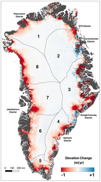
Integrating data from multiple satellite altimetry missions, we analyzed Greenland’s peripheral glaciers and Ice Sheet (GrIS) from 1992–2023. Our methodology ensures consistent, reliable elevation change data, now publicly available via NASA's ITS_LIVE project. The GrIS lost an average of -160 ± 17 Gt a-1 and peripheral glaciers -23 ± 5 Gt a-1 from 1992–2023. The study highlights the importance of continued monitoring to understand climate change impacts on Earth's Cryosphere.
Thorsten Seehaus, Alex S. Gardner, and Johan Nilsson
EGUsphere, https://doi.org/10.5194/egusphere-2025-6417, https://doi.org/10.5194/egusphere-2025-6417, 2026
Short summary
Short summary
Satellite altimeters only sample surface heights at scattered points. We developed a method to turn these measurements into maps of glacier height change while also estimating how reliable the results are. Applying this approach to glaciers in Svalbard and Antarctica shows strong ice loss and clearly captures short-lived events such as glacier surges. Our results improve the ability to monitor glacier change in difficult terrain and help better assess future contributions to sea level rise.
Maria T. Kappelsberger, Johan Nilsson, Martin Horwath, Veit Helm, and Alex S. Gardner
EGUsphere, https://doi.org/10.5194/egusphere-2025-5745, https://doi.org/10.5194/egusphere-2025-5745, 2025
Short summary
Short summary
We compare surface elevation changes of the Antarctic Ice Sheet interior as derived from satellite radar altimetry and laser altimetry between 2019 and 2024. Both methods indicate an increase in surface elevation across most of the study area, coinciding with an episode of excess snow accumulation as modelled. However, rates of surface elevation increase from radar altimetry are systematically lower than those from laser altimetry.
Alex S. Gardner, Chad A. Greene, Joseph H. Kennedy, Mark A. Fahnestock, Maria Liukis, Luis A. López, Yang Lei, Ted A. Scambos, and Amaury Dehecq
The Cryosphere, 19, 3517–3533, https://doi.org/10.5194/tc-19-3517-2025, https://doi.org/10.5194/tc-19-3517-2025, 2025
Short summary
Short summary
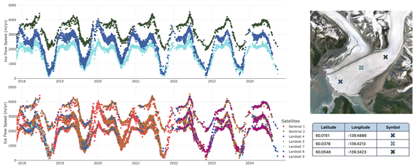
The NASA MEaSUREs Inter-mission Time Series of Land Ice Velocity and Elevation (ITS_LIVE) project provides glacier and ice sheet velocity products for the full Landsat, Sentinel-1, and Sentinel-2 satellite archives and will soon include data from the NISAR satellite. This paper describes the ITS_LIVE processing chain and gives guidance for working with the cloud-optimized glacier and ice sheet velocity products.
Brian Menounos, Alex Gardner, Caitlyn Florentine, and Andrew Fountain
The Cryosphere, 18, 889–894, https://doi.org/10.5194/tc-18-889-2024, https://doi.org/10.5194/tc-18-889-2024, 2024
Short summary
Short summary
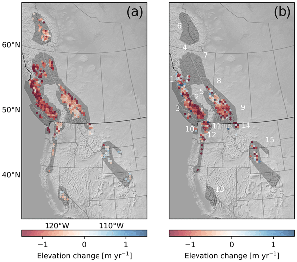
Glaciers in western North American outside of Alaska are often overlooked in global studies because their potential to contribute to changes in sea level is small. Nonetheless, these glaciers represent important sources of freshwater, especially during times of drought. We show that these glaciers lost mass at a rate of about 12 Gt yr-1 for about the period 2013–2021; the rate of mass loss over the period 2018–2022 was similar.
Youngmin Choi, Helene Seroussi, Mathieu Morlighem, Nicole-Jeanne Schlegel, and Alex Gardner
The Cryosphere, 17, 5499–5517, https://doi.org/10.5194/tc-17-5499-2023, https://doi.org/10.5194/tc-17-5499-2023, 2023
Short summary
Short summary
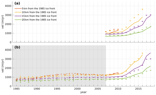
Ice sheet models are often initialized using snapshot observations of present-day conditions, but this approach has limitations in capturing the transient evolution of the system. To more accurately represent the accelerating changes in glaciers, we employed time-dependent data assimilation. We found that models calibrated with the transient data better capture past trends and more accurately reproduce changes after the calibration period, even with limited observations.
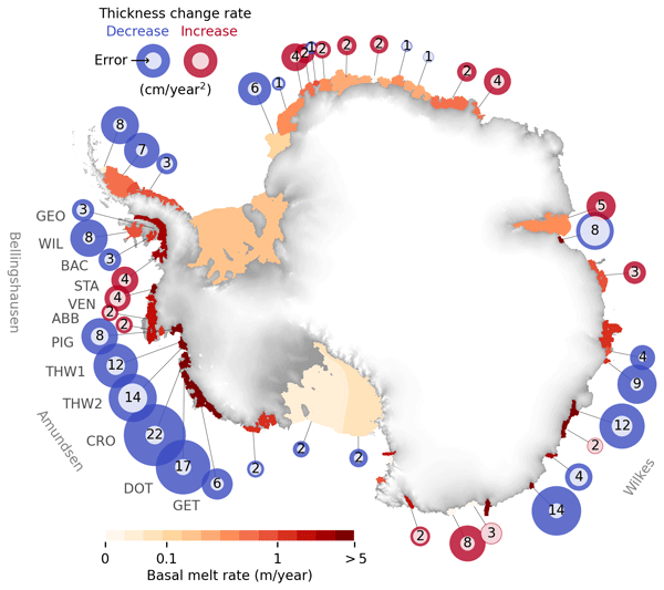
Fernando S. Paolo, Alex S. Gardner, Chad A. Greene, Johan Nilsson, Michael P. Schodlok, Nicole-Jeanne Schlegel, and Helen A. Fricker
The Cryosphere, 17, 3409–3433, https://doi.org/10.5194/tc-17-3409-2023, https://doi.org/10.5194/tc-17-3409-2023, 2023
Short summary
Short summary
We report on a slowdown in the rate of thinning and melting of West Antarctic ice shelves. We present a comprehensive assessment of the Antarctic ice shelves, where we analyze at a continental scale the changes in thickness, flow, and basal melt over the past 26 years. We also present a novel method to estimate ice shelf change from satellite altimetry and a time-dependent data set of ice shelf thickness and basal melt rates at an unprecedented resolution.
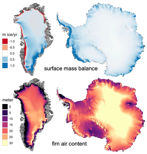
Alex S. Gardner, Nicole-Jeanne Schlegel, and Eric Larour
Geosci. Model Dev., 16, 2277–2302, https://doi.org/10.5194/gmd-16-2277-2023, https://doi.org/10.5194/gmd-16-2277-2023, 2023
Short summary
Short summary
This is the first description of the open-source Glacier Energy and Mass Balance (GEMB) model. GEMB models the ice sheet and glacier surface–atmospheric energy and mass exchange, as well as the firn state. The model is evaluated against the current state of the art and in situ observations and is shown to perform well.
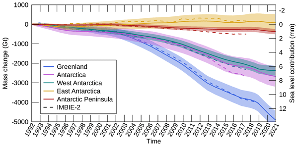
Inès N. Otosaka, Andrew Shepherd, Erik R. Ivins, Nicole-Jeanne Schlegel, Charles Amory, Michiel R. van den Broeke, Martin Horwath, Ian Joughin, Michalea D. King, Gerhard Krinner, Sophie Nowicki, Anthony J. Payne, Eric Rignot, Ted Scambos, Karen M. Simon, Benjamin E. Smith, Louise S. Sørensen, Isabella Velicogna, Pippa L. Whitehouse, Geruo A, Cécile Agosta, Andreas P. Ahlstrøm, Alejandro Blazquez, William Colgan, Marcus E. Engdahl, Xavier Fettweis, Rene Forsberg, Hubert Gallée, Alex Gardner, Lin Gilbert, Noel Gourmelen, Andreas Groh, Brian C. Gunter, Christopher Harig, Veit Helm, Shfaqat Abbas Khan, Christoph Kittel, Hannes Konrad, Peter L. Langen, Benoit S. Lecavalier, Chia-Chun Liang, Bryant D. Loomis, Malcolm McMillan, Daniele Melini, Sebastian H. Mernild, Ruth Mottram, Jeremie Mouginot, Johan Nilsson, Brice Noël, Mark E. Pattle, William R. Peltier, Nadege Pie, Mònica Roca, Ingo Sasgen, Himanshu V. Save, Ki-Weon Seo, Bernd Scheuchl, Ernst J. O. Schrama, Ludwig Schröder, Sebastian B. Simonsen, Thomas Slater, Giorgio Spada, Tyler C. Sutterley, Bramha Dutt Vishwakarma, Jan Melchior van Wessem, David Wiese, Wouter van der Wal, and Bert Wouters
Earth Syst. Sci. Data, 15, 1597–1616, https://doi.org/10.5194/essd-15-1597-2023, https://doi.org/10.5194/essd-15-1597-2023, 2023
Short summary
Short summary
By measuring changes in the volume, gravitational attraction, and ice flow of Greenland and Antarctica from space, we can monitor their mass gain and loss over time. Here, we present a new record of the Earth’s polar ice sheet mass balance produced by aggregating 50 satellite-based estimates of ice sheet mass change. This new assessment shows that the ice sheets have lost (7.5 x 10¹²) t of ice between 1992 and 2020, contributing 21 mm to sea level rise.

Yang Lei, Alex S. Gardner, and Piyush Agram
Earth Syst. Sci. Data, 14, 5111–5137, https://doi.org/10.5194/essd-14-5111-2022, https://doi.org/10.5194/essd-14-5111-2022, 2022
Short summary
Short summary
This work describes NASA MEaSUREs ITS_LIVE project's Version 2 Sentinel-1 image-pair ice velocity product and processing methodology. We show the refined offset tracking algorithm, autoRIFT, calibration for Sentinel-1 geolocation biases and correction of the ionosphere streaking problems. Validation was performed over three typical test sites covering the globe by comparing with other similar global and regional products.
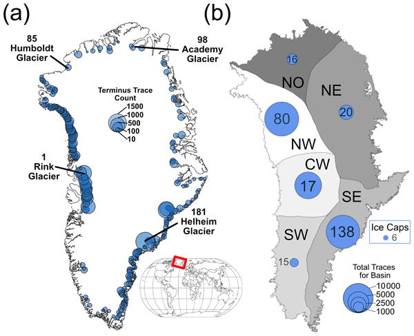
Sophie Goliber, Taryn Black, Ginny Catania, James M. Lea, Helene Olsen, Daniel Cheng, Suzanne Bevan, Anders Bjørk, Charlie Bunce, Stephen Brough, J. Rachel Carr, Tom Cowton, Alex Gardner, Dominik Fahrner, Emily Hill, Ian Joughin, Niels J. Korsgaard, Adrian Luckman, Twila Moon, Tavi Murray, Andrew Sole, Michael Wood, and Enze Zhang
The Cryosphere, 16, 3215–3233, https://doi.org/10.5194/tc-16-3215-2022, https://doi.org/10.5194/tc-16-3215-2022, 2022
Short summary
Short summary
Terminus traces have been used to understand how Greenland's glaciers have changed over time; however, manual digitization is time-intensive, and a lack of coordination leads to duplication of efforts. We have compiled a dataset of over 39 000 terminus traces for 278 glaciers for scientific and machine learning applications. We also provide an overview of an updated version of the Google Earth Engine Digitization Tool (GEEDiT), which has been developed specifically for the Greenland Ice Sheet.
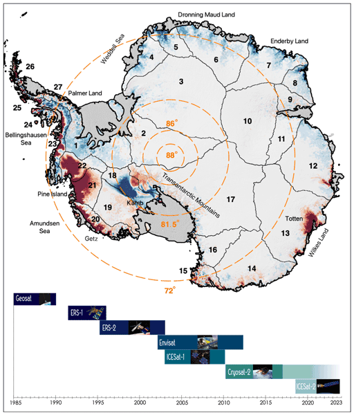
Johan Nilsson, Alex S. Gardner, and Fernando S. Paolo
Earth Syst. Sci. Data, 14, 3573–3598, https://doi.org/10.5194/essd-14-3573-2022, https://doi.org/10.5194/essd-14-3573-2022, 2022
Short summary
Short summary
The longest observational record available to study the mass balance of the Earth’s ice sheets comes from satellite altimeters. This record consists of multiple satellite missions with different measurements and quality, and it must be cross-calibrated and integrated into a consistent record for scientific use. Here, we present a novel approach for generating such a record providing a seamless record of elevation change for the Antarctic Ice Sheet that spans the period 1985 to 2020.
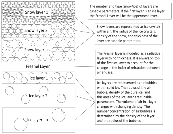
Chloe A. Whicker, Mark G. Flanner, Cheng Dang, Charles S. Zender, Joseph M. Cook, and Alex S. Gardner
The Cryosphere, 16, 1197–1220, https://doi.org/10.5194/tc-16-1197-2022, https://doi.org/10.5194/tc-16-1197-2022, 2022
Short summary
Short summary
Snow and ice surfaces are important to the global climate. Current climate models use measurements to determine the reflectivity of ice. This model uses physical properties to determine the reflectivity of snow, ice, and darkly pigmented impurities that reside within the snow and ice. Therefore, the modeled reflectivity is more accurate for snow/ice columns under varying climate conditions. This model paves the way for improvements in the portrayal of snow and ice within global climate models.
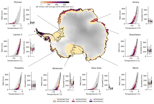
Marte Gé Hofsteenge, Willem Jan van de Berg, Christiaan van Dalum, Kristiina Verro, Maurice van Tiggelen, and Michiel van den Broeke
The Cryosphere, 20, 4747–4766, https://doi.org/10.5194/tc-20-4747-2026, https://doi.org/10.5194/tc-20-4747-2026, 2026
Short summary
Short summary
We use a regional climate model to study how surface melt on Antarctic ice shelves responds to air temperature. The relationship is strongly non-linear, mainly due to feedbacks in surface albedo, with other energy sources also contributing. Currently colder, drier, and more stable ice shelves will experience more melt at the same temperature than ice shelves in wetter climates, highlighting their vulnerability to fracturing, ice shelf instability, and contributions to global sea-level rise.
David N. Wiese, Johan Nilsson, Nicole-Jeanne Schlegel, Alex S. Gardner, Matthias Ellmer, and Felix W. Landerer
EGUsphere, https://doi.org/10.5194/egusphere-2026-4404, https://doi.org/10.5194/egusphere-2026-4404, 2026
This preprint is open for discussion and under review for The Cryosphere (TC).
Short summary
Short summary
Tracking Antarctic ice loss is vital for predicting sea-level rise. Satellite gravity measurements reliably track overall mass changes, while height measurements capture fine local details. We combined two decades of both satellite records into a unified model. This boosts mapping clarity tenfold, revealing ice loss from broad regional scales down to individual glaciers. These refined maps help scientists monitor vulnerable ice streams and improve climate projections.
Sanne B. M. Veldhuijsen, Peter Kuipers Munneke, Willem Jan van de Berg, Michiel R. van den Broeke, and Luke D. Trusel
EGUsphere, https://doi.org/10.5194/egusphere-2026-3453, https://doi.org/10.5194/egusphere-2026-3453, 2026
This preprint is open for discussion and under review for The Cryosphere (TC).
Short summary
Short summary
Antarctica has floating ice shelves around its perimeter that provide stability to the ice sheet. As temperature rises, snow on the ice shelves may melt away, and ponding of meltwater may cause the ice shelves to collapse. If that happens, Antarctica may start to lose ice faster than before, resulting in accelerated sea-level rise. The tool presented in this article will be used in simulations of future climate to determine when climate change leads to collapse of the ice shelves in Antarctica.
Jing Zhang, Yang Lei, Laurane Charrier, Amaury Dehecq, Alex S. Gardner, Luke Copland, and Christine Dow
EGUsphere, https://doi.org/10.5194/egusphere-2026-2541, https://doi.org/10.5194/egusphere-2026-2541, 2026
This preprint is open for discussion and under review for The Cryosphere (TC).
Short summary
Short summary
Satellites can measure how fast glaciers move, which helps scientists understand ice loss and rising sea levels. However, these measurements have rarely been checked against ground-based observations on small mountain glaciers. We compared satellite-derived glacier speeds against precise ground measurements. The satellite data generally agreed well with ground observations. Our results help scientists use satellite glacier velocity data more reliably.
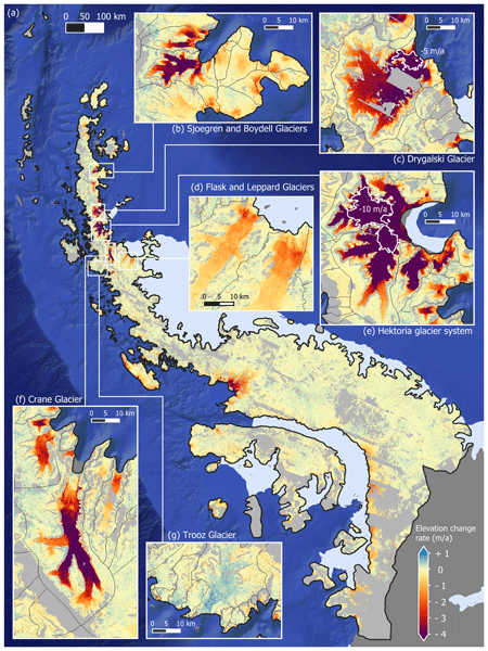
Maud Bernat, Etienne Berthier, Amaury Dehecq, Romain Hugonnet, Joaquin M. C. Belart, Naomi Ochwat, Peter Kuipers Munneke, Elizabeth Case, Ted Scambos, Louis-Marie Gauer, and David Youssefi
The Cryosphere, 20, 3025–3049, https://doi.org/10.5194/tc-20-3025-2026, https://doi.org/10.5194/tc-20-3025-2026, 2026
Short summary
Short summary
The Antarctic Peninsula is a mountainous region containing an ice sheet and peripheral glaciers. Differences remain between the methods used to estimate its mass changes. We use thousands of digital elevation models derived from high resolution stereoscopic images to calculate a new estimate of mass changes. We find that between 2007 and 2021, the ice sheet lost -28±6Gt/a and its peripheral glaciers -14±3Gt/a. We highlight the importance of resolving fine-scale changes in complex coastal areas.
Fredrik Boberg, Xavier Fettweis, Nicolaj Hansen, Ruth Mottram, and Michiel R. van den Broeke
The Cryosphere, 20, 2947–2960, https://doi.org/10.5194/tc-20-2947-2026, https://doi.org/10.5194/tc-20-2947-2026, 2026
Short summary
Short summary
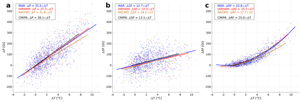
An ensemble of regional climate model simulations is used to estimate the 21st century change in precipitation on the Greenland ice sheet. For the end of the century, the change is in the range 40 to 170 Gt per year, depending on the emission scenario. Using annual values of 2 m air temperature and precipitation, we estimate an increase in precipitation of 35 Gt per year for every degree of warming.
Samuel M. Tax, Maurice van Tiggelen, Thirza N. Feenstra, Paul C. J. P. Smeets, Srinidhi N. Gadde, Christiaan T. van Dalum, Willem Jan van de Berg, and Michiel R. van den Broeke
EGUsphere, https://doi.org/10.5194/egusphere-2026-1926, https://doi.org/10.5194/egusphere-2026-1926, 2026
Short summary
Short summary
Strong winds can lift snow into the air, which influences the energy exchange between the surface and the atmosphere. We studied this phenomenon over the Greenland Ice Sheet using observations and a climate model. We found that blowing snow traps heat near the surface like a blanket and reflects incoming sunlight like a mirror. Simulating these processes increases the net energy at the surface and improves model accuracy. Therefore, we recommend including these effects in climate models.
Alberto C. Naveira Garabato, Carl P. Spingys, Andrew J. Lucas, Tiago S. Dotto, Christian T. Wild, Scott W. Tyler, Ted A. Scambos, Christopher B. Kratt, Giuseppe Cappelli, Ethan F. Williams, Mariona Claret, Hannah E. Glover, Meagan E. Wengrove, Madison M. Smith, Michael G. Baker, Giuseppe Marra, Max Tamussino, Zitong Feng, David Lloyd, Liam Taylor, Mikael Mazur, Maria-Daphne Mangriotis, Aaron Micallef, Jennifer Ward Neale, Oleg A. Godin, Matthew H. Alford, Emma P. M. Gregory, Michael A. Clare, Hamid Shiri, Angel Ruiz Angulo, Kathryn L. Gunn, Ben I. Moat, Isobel A. Yeo, Afonso Loureiro, Alessandro Silvano, Arthur Hartog, and Mohammad Belal
Ocean Sci., 22, 1129–1167, https://doi.org/10.5194/os-22-1129-2026, https://doi.org/10.5194/os-22-1129-2026, 2026
Short summary
Short summary
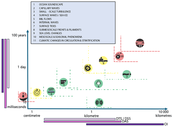
Distributed optical fibre sensing (DOFS) is a technology that enables continuous, real-time measurements of environmental parameters along a fibre optic cable. Here, we review the recently emerged applications of DOFS in physical oceanography, and offer a perspective on the technology’s potential for future growth in the field.
Johan Nilsson and Alex S. Gardner
Earth Syst. Sci. Data, 18, 1729–1745, https://doi.org/10.5194/essd-18-1729-2026, https://doi.org/10.5194/essd-18-1729-2026, 2026
Short summary
Short summary
Integrating data from multiple satellite altimetry missions, we analyzed Greenland’s peripheral glaciers and Ice Sheet (GrIS) from 1992–2023. Our methodology ensures consistent, reliable elevation change data, now publicly available via NASA's ITS_LIVE project. The GrIS lost an average of -160 ± 17 Gt a-1 and peripheral glaciers -23 ± 5 Gt a-1 from 1992–2023. The study highlights the importance of continued monitoring to understand climate change impacts on Earth's Cryosphere.
Vikram Goel, Carlos Martín, Kenichi Matsuoka, Bhanu Pratap, Geir Moholdt, Rahul Dey, Chavarukonam M. Laluraj, and Meloth Thamban
The Cryosphere, 20, 1363–1378, https://doi.org/10.5194/tc-20-1363-2026, https://doi.org/10.5194/tc-20-1363-2026, 2026
Short summary
Short summary
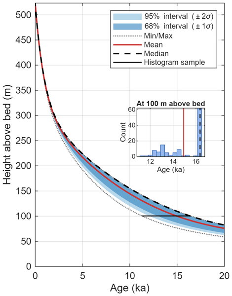
We identified an ideal site in coastal East Antarctica for extracting ice core that contain detailed climate records dating back 20 000 years. We surveyed two ice rises combining radar measurements with ice flow modeling to assess their suitability. One site emerged as optimal, offering well-preserved climate history with high temporal resolution. An ice core record from this site could help us understand historical interactions between sea ice, winds, and precipitation patterns in the region.
Benjamin Heurgue, Charles Amory, Christoph Kittel, Fredrik Boberg, Gaël Durand, Vincent Favier, Xavier Fettweis, Quentin Glaude, Heiko Goelzer, Nicolaj Hansen, Nicolas C. Jourdain, Ruth Mottram, Martin Olesen, Willem Jan Van de Berg, Michiel R. Van den Broeke, and René R. Wijngaard
EGUsphere, https://doi.org/10.5194/egusphere-2026-624, https://doi.org/10.5194/egusphere-2026-624, 2026
Short summary
Short summary
We studied how the Antarctic ice sheet surface mass balance may change by 2100 using three high-resolution climate models forced by the same future climate scenario. While the models agree for present-day conditions, they project very different futures, especially over floating ice shelves. These differences mainly come from how melting, refreezing, and temperature are represented. Our results show that future sea level projections strongly depend on how well models simulate today’s climate.
Thirza N. Feenstra, Willem Jan van de Berg, Gerd-Jan van Zadelhoff, David P. Donovan, Christiaan T. van Dalum, and Michiel R. van den Broeke
Atmos. Meas. Tech., 19, 1323–1344, https://doi.org/10.5194/amt-19-1323-2026, https://doi.org/10.5194/amt-19-1323-2026, 2026
Short summary
Short summary
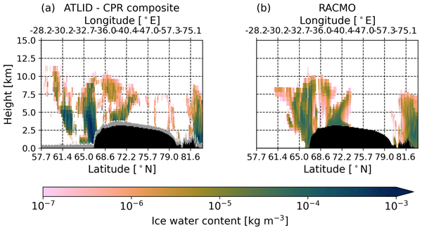
Cloud representation brings large uncertainties in polar climate modeling. We show the first evaluation of Greenland clouds in the Regional Atmospheric Climate Model (RACMO2.4) with new EarthCARE satellite data. Comparing lidar and radar observations and retrieved cloud profiles with co-located RACMO output, we find RACMO captures low ice clouds but underestimates high clouds, mid-altitude liquid clouds, and snowfall. These results highlight EarthCARE's potential to improve polar climate models.
Tesse E. A. van den Aker, Peter Kuipers Munneke, Willem Jan van de Berg, Walter W. Immerzeel, and Michiel R. van den Broeke
EGUsphere, https://doi.org/10.5194/egusphere-2026-462, https://doi.org/10.5194/egusphere-2026-462, 2026
Short summary
Short summary
The firn layer, i.e. permanent snow, regulates how an ice sheet responds to climate change. Firn models are forced with with climate data at time steps from sub-daily to annual in literature, however, implications are barely evaluated. We test the impact of different climate forcing time steps on the modeled firn layer. We conclude that the climate forcing time step (1) affects firn model output, (2) can lead to non-physical behaviour, and (3) that resolving at least a diurnal cycle is required.
Thorsten Seehaus, Alex S. Gardner, and Johan Nilsson
EGUsphere, https://doi.org/10.5194/egusphere-2025-6417, https://doi.org/10.5194/egusphere-2025-6417, 2026
Short summary
Short summary
Satellite altimeters only sample surface heights at scattered points. We developed a method to turn these measurements into maps of glacier height change while also estimating how reliable the results are. Applying this approach to glaciers in Svalbard and Antarctica shows strong ice loss and clearly captures short-lived events such as glacier surges. Our results improve the ability to monitor glacier change in difficult terrain and help better assess future contributions to sea level rise.
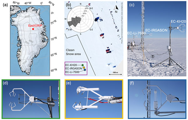
Ida Haven, Hans Christian Steen-Larsen, Laura J. Dietrich, Sonja Wahl, Jason E. Box, Michiel R. van den Broeke, Alun Hubbard, Stephan T. Kral, Joachim Reuder, and Maurice van Tiggelen
The Cryosphere, 20, 573–593, https://doi.org/10.5194/tc-20-573-2026, https://doi.org/10.5194/tc-20-573-2026, 2026
Short summary
Short summary
Three independent Eddy-Covariance measurement systems deployed on top of the Greenland Ice Sheet are compared. Using this dataset, we evaluate the reproducibility and quantify the differences between the systems. The fidelity of two regional climate models in capturing the seasonal variability in the latent and sensible heat flux between the snow surface and the atmosphere is assessed. We identify differences between observations and model simulations, especially during the winter period.

Horst Machguth, Andrew Tedstone, Peter Kuipers Munneke, Max Brils, Brice Noël, Nicole Clerx, Nicolas Jullien, Xavier Fettweis, and Michiel van den Broeke
The Cryosphere, 20, 427–452, https://doi.org/10.5194/tc-20-427-2026, https://doi.org/10.5194/tc-20-427-2026, 2026
Short summary
Short summary
Due to increasing air temperatures, surface melt expands to higher elevations on the Greenland ice sheet. This is visible on satellite imagery in the form of rivers of meltwater running across the surface of the ice sheet. We compare model results of meltwater at high elevations on the ice sheet to satellite observations. We find that each of the models shows strengths and weaknesses. A detailed look into the model results reveals potential reasons for the differences between models.
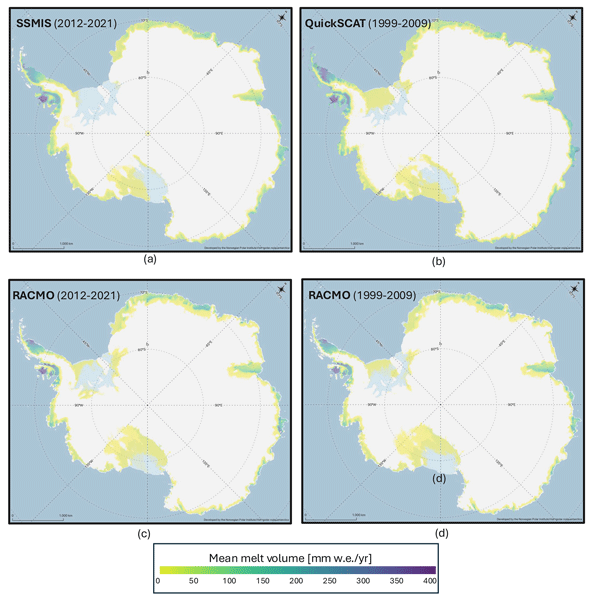
Valeria Di Biase, Peter Kuipers Munneke, Bert Wouters, Michiel R. van den Broeke, and Maurice van Tiggelen
The Cryosphere, 20, 87–96, https://doi.org/10.5194/tc-20-87-2026, https://doi.org/10.5194/tc-20-87-2026, 2026
Short summary
Short summary
We produce annual maps of Antarctic surface melt volumes from 2012 to 2021 using satellite microwave data. We detect melting days from thresholds on the satellite signal and then use actual melt measurements from weather stations to convert those signals into water‑equivalent volumes. Our maps capture known melt hotspots and show slightly lower totals than climate models. This dataset supports climate and ice‑shelf studies.

Heiko Goelzer, Constantijn J. Berends, Fredrik Boberg, Gael Durand, Tamsin L. Edwards, Xavier Fettweis, Fabien Gillet-Chaulet, Quentin Glaude, Philippe Huybrechts, Sébastien Le clec'h, Ruth Mottram, Brice Noël, Martin Olesen, Charlotte Rahlves, Jeremy Rohmer, Michiel van den Broeke, and Roderik S. W. van de Wal
The Cryosphere, 19, 6887–6906, https://doi.org/10.5194/tc-19-6887-2025, https://doi.org/10.5194/tc-19-6887-2025, 2025
Short summary
Short summary
We present an ensemble of ice sheet model projections for the Greenland ice sheet. The focus is on providing projections that improve our understanding of the range future sea-level rise and the inherent uncertainties over the next 100 to 300 years. Compared to earlier work we more fully account for some of the uncertainties in sea-level projections. We include a wider range of climate model output, more climate change scenarios and we extend projections schematically up to year 2300.
Maria T. Kappelsberger, Johan Nilsson, Martin Horwath, Veit Helm, and Alex S. Gardner
EGUsphere, https://doi.org/10.5194/egusphere-2025-5745, https://doi.org/10.5194/egusphere-2025-5745, 2025
Short summary
Short summary
We compare surface elevation changes of the Antarctic Ice Sheet interior as derived from satellite radar altimetry and laser altimetry between 2019 and 2024. Both methods indicate an increase in surface elevation across most of the study area, coinciding with an episode of excess snow accumulation as modelled. However, rates of surface elevation increase from radar altimetry are systematically lower than those from laser altimetry.
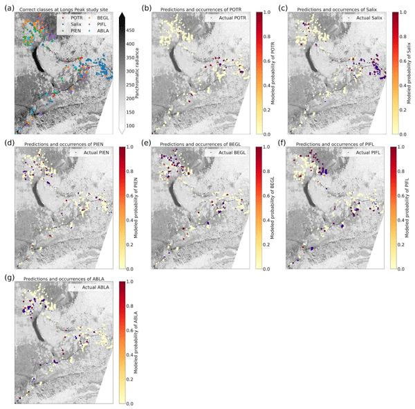
Laurel A. Sindewald, Ryan Lagerquist, Matthew D. Cross, Theodore A. Scambos, Peter J. Anthamatten, and Diana F. Tomback
Biogeosciences, 22, 6509–6543, https://doi.org/10.5194/bg-22-6509-2025, https://doi.org/10.5194/bg-22-6509-2025, 2025
Short summary
Short summary
We used high-resolution satellite imagery and artificial intelligence models to identify six tree and shrub species commonly found at alpine treeline in the Rocky Mountains with accuracies from 44.1% to 86.2%. We are the first to attempt species identification using satellite imagery in treeline systems, where trees are small and difficult to identify remotely. Our work provides a method to identify species with satellite imagery over a broader geographic range than can be achieved with drones.
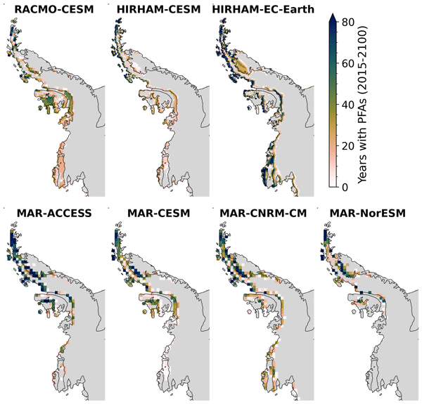
Sanne B. M. Veldhuijsen, Willem Jan van de Berg, Peter Kuipers Munneke, Nicolaj Hansen, Fredrik Boberg, Christoph Kittel, Charles Amory, and Michiel R. van den Broeke
The Cryosphere, 19, 5157–5173, https://doi.org/10.5194/tc-19-5157-2025, https://doi.org/10.5194/tc-19-5157-2025, 2025
Short summary
Short summary
Perennial firn aquifers (PFAs), year-round bodies of liquid water within firns, can potentially impact ice-shelf and ice-sheet stability. We developed a fast XGBoost firn emulator to predict the 21st-century distribution of PFAs in Antarctica for 12 climatic forcing datasets. Our findings suggest that, in low-emission scenarios, PFAs remain confined to the Antarctic Peninsula. However, in a high-emission scenario, PFAs are projected to expand to a region in West Antarctica and East Antarctica.
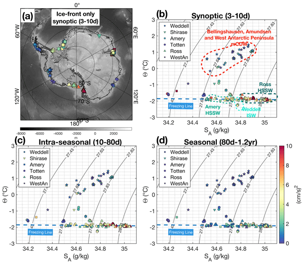
Shenjie Zhou, Pierre Dutrieux, Claudia F. Giulivi, Adrian Jenkins, Alessandro Silvano, Christopher Auckland, E. Povl Abrahamsen, Michael Meredith, Irena Vaňková, Keith Nicholls, Peter E. D. Davis, Svein Østerhus, Arnold L. Gordon, Christopher J. Zappa, Tiago S. Dotto, Ted Scambos, Kathryn L. Gunn, Stephen R. Rintoul, Shigeru Aoki, Craig Stevens, Chengyan Liu, Sukyoung Yun, Tae-Wan Kim, Won Sang Lee, Markus Janout, Tore Hattermann, Julius Lauber, Elin Darelius, Anna Wåhlin, Leo Middleton, Pasquale Castagno, Giorgio Budillon, Karen J. Heywood, Jennifer Graham, Stephen Dye, Daisuke Hirano, and Una Kim Miller
Earth Syst. Sci. Data, 17, 5693–5706, https://doi.org/10.5194/essd-17-5693-2025, https://doi.org/10.5194/essd-17-5693-2025, 2025
Short summary
Short summary
We created the first standardised dataset of in-situ ocean measurements time series from around Antarctica collected since 1970s. This includes temperature, salinity, pressure, and currents recorded by instruments deployed in icy, challenging conditions. Our analysis highlights the dominance of tidal currents and separates these from other patterns to study regional energy distribution. This unique dataset offers a foundation for future research on Antarctic ocean dynamics and ice interactions.
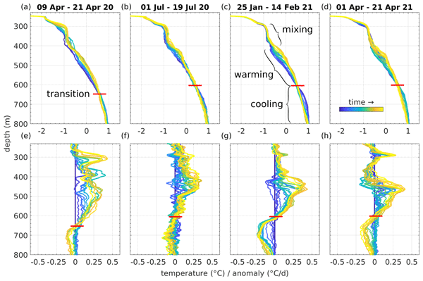
Christian T. Wild, Tasha Snow, Tiago S. Dotto, Peter E. D. Davis, Scott Tyler, Ted A. Scambos, Erin C. Pettit, and Karen J. Heywood
Ocean Sci., 21, 2605–2629, https://doi.org/10.5194/os-21-2605-2025, https://doi.org/10.5194/os-21-2605-2025, 2025
Short summary
Short summary
Thwaites Glacier is retreating due to warm ocean water melting it from below, but its thick ice shelf makes this heat hard to monitor. Using hot-water drilling, we placed sensors beneath the floating ice, revealing how surface freezing in Pine Island Bay influences heat at depth. Alongside gradual warming, we found bursts of heat that could speed up melting at the grounding zone, which may become more common as sea ice declines.
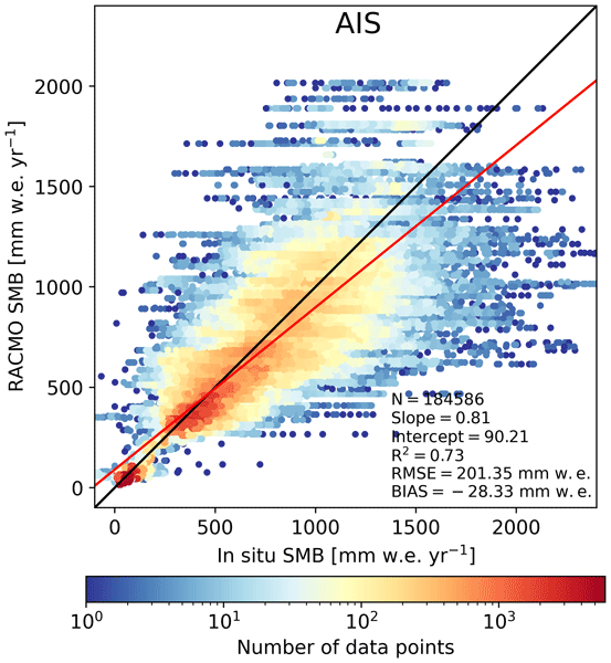
Christiaan T. van Dalum, Willem Jan van de Berg, Michiel R. van den Broeke, and Maurice van Tiggelen
The Cryosphere, 19, 4061–4090, https://doi.org/10.5194/tc-19-4061-2025, https://doi.org/10.5194/tc-19-4061-2025, 2025
Short summary
Short summary
In this study, we present a new surface mass balance (SMB) and near-surface climate product for Antarctica with the regional climate model RACMO2.4p1. We assess the impact of major model updates on the climate of Antarctica. Locally, the SMB has changed substantially but also agrees well with observations. In addition, we show that the SMB components, surface energy budget, albedo, pressure, temperature, and wind speed compare well with in situ and remote sensing observations.
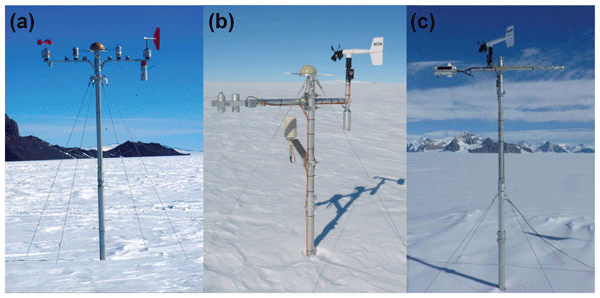
Maurice van Tiggelen, Paul C. J. P. Smeets, Carleen H. Reijmer, Peter Kuipers Munneke, and Michiel R. van den Broeke
Earth Syst. Sci. Data, 17, 4933–4955, https://doi.org/10.5194/essd-17-4933-2025, https://doi.org/10.5194/essd-17-4933-2025, 2025
Short summary
Short summary
This paper describes the measurements from the 19 IMAU (Institute for Marine and Atmospheric research Utrecht) automatic weather stations that operated on the Antarctic ice sheet from 1995 through 2022. These stations also measured the net surface radiation and surface height change, allowing for the quantification of the surface energy and mass balance at hourly resolution. These data are invaluable for the evaluation of atmospheric models and for the detection of climatological changes.
Anneke L. Vries, Willem Jan van de Berg, Brice Noël, Lorenz Meire, and Michiel R. van den Broeke
The Cryosphere, 19, 3897–3914, https://doi.org/10.5194/tc-19-3897-2025, https://doi.org/10.5194/tc-19-3897-2025, 2025
Short summary
Short summary
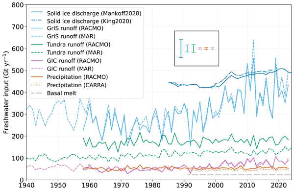
Freshwater flows into Greenland's fjords from various sources. Solid ice discharge (e.g. calving icebergs) dominates freshwater input in the southeast and northwest. In contrast, in the southwest, runoff from the ice sheet and tundra are the most significant. Seasonal data revealed that fjord precipitation and tundra runoff contribute up to 11 % and 35 % of the monthly freshwater input, respectively. Our results provide valuable input for ocean models and for researchers studying fjord ecosystems.
Alex S. Gardner, Chad A. Greene, Joseph H. Kennedy, Mark A. Fahnestock, Maria Liukis, Luis A. López, Yang Lei, Ted A. Scambos, and Amaury Dehecq
The Cryosphere, 19, 3517–3533, https://doi.org/10.5194/tc-19-3517-2025, https://doi.org/10.5194/tc-19-3517-2025, 2025
Short summary
Short summary
The NASA MEaSUREs Inter-mission Time Series of Land Ice Velocity and Elevation (ITS_LIVE) project provides glacier and ice sheet velocity products for the full Landsat, Sentinel-1, and Sentinel-2 satellite archives and will soon include data from the NISAR satellite. This paper describes the ITS_LIVE processing chain and gives guidance for working with the cloud-optimized glacier and ice sheet velocity products.
Douglas J. Brinkerhoff, Brandon S. Tober, Michael Daniel, Victor Devaux-Chupin, Michael S. Christoffersen, John W. Holt, Christopher F. Larsen, Mark Fahnestock, Michael G. Loso, Kristin M. F. Timm, Russell C. Mitchell, and Martin Truffer
The Cryosphere, 19, 2321–2353, https://doi.org/10.5194/tc-19-2321-2025, https://doi.org/10.5194/tc-19-2321-2025, 2025
Short summary
Short summary
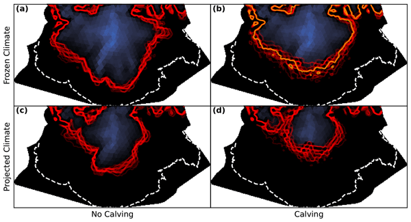
Sít' Tlein is one of the largest glaciers in the world outside of the polar regions, and we know that it has been rapidly thinning. To forecast how this glacier will change in the future, we combine a computer model of ice flow with measurements from many different sources. Our model tells us that with high probability, Sít' Tlein's lower reaches are going to disappear in the next century and a half, creating a new bay or lake along Alaska's coastline.
Shfaqat A. Khan, Helene Seroussi, Mathieu Morlighem, William Colgan, Veit Helm, Gong Cheng, Danjal Berg, Valentina R. Barletta, Nicolaj K. Larsen, William Kochtitzky, Michiel van den Broeke, Kurt H. Kjær, Andy Aschwanden, Brice Noël, Jason E. Box, Joseph A. MacGregor, Robert S. Fausto, Kenneth D. Mankoff, Ian M. Howat, Kuba Oniszk, Dominik Fahrner, Anja Løkkegaard, Eigil Y. H. Lippert, Alicia Bråtner, and Javed Hassan
Earth Syst. Sci. Data, 17, 3047–3071, https://doi.org/10.5194/essd-17-3047-2025, https://doi.org/10.5194/essd-17-3047-2025, 2025
Short summary
Short summary
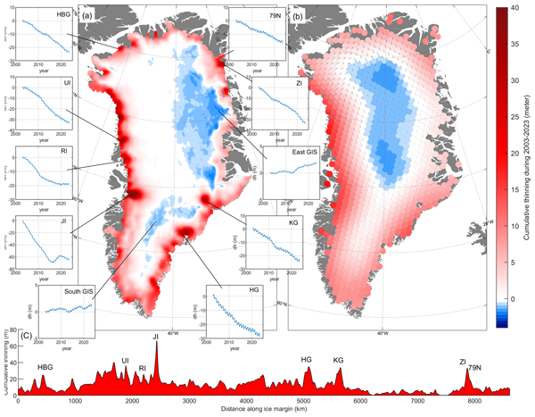
The surface elevation of the Greenland Ice Sheet is changing due to surface mass balance processes and ice dynamics, each exhibiting distinct spatiotemporal patterns. Here, we employ satellite and airborne altimetry data with fine spatial (1 km) and temporal (monthly) resolutions to document this spatiotemporal evolution from 2003 to 2023. This dataset of fine-resolution altimetry data in both space and time will support studies of ice mass loss and be useful for GIS ice sheet modeling.
Joseph A. MacGregor, Mark A. Fahnestock, John D. Paden, Jilu Li, Jeremy P. Harbeck, and Andy Aschwanden
Earth Syst. Sci. Data, 17, 2911–2931, https://doi.org/10.5194/essd-17-2911-2025, https://doi.org/10.5194/essd-17-2911-2025, 2025
Short summary
Short summary
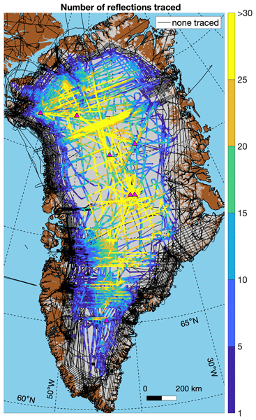
This paper describes the second version of a deep radiostratigraphic database for the Greenland Ice Sheet. It includes numerous improvements to the original database from 2015 and includes newer high-quality radar sounding data from 2014–2019. It represents a unique and widespread constraint on the history of the ice sheet that could be helpful to initialize and interpret ice-sheet models.
Ankita Vashishtha, Pietro Milillo, Alexandre Becker Campos, Jose Luis Bueso Bello, Paola Rizzoli, and Johan Nilsson
EGUsphere, https://doi.org/10.5194/egusphere-2025-1979, https://doi.org/10.5194/egusphere-2025-1979, 2025
Short summary
Short summary
We developed a new method to improve satellite elevation models of Antarctica by using artificial intelligence. Our method combines radar and laser satellite data with weather information to correct for measurement errors caused by radar signals penetrating snow and ice. This makes elevation maps up to ten times more accurate compared to current , helping scientists better track changes in ice and snow. Our results directly inform future space missions to monitor Earth’s changing surface.
Jennifer F. Arthur, Calvin Shackleton, Geir Moholdt, Kenichi Matsuoka, and Jelte van Oostveen
The Cryosphere, 19, 375–392, https://doi.org/10.5194/tc-19-375-2025, https://doi.org/10.5194/tc-19-375-2025, 2025
Short summary
Short summary
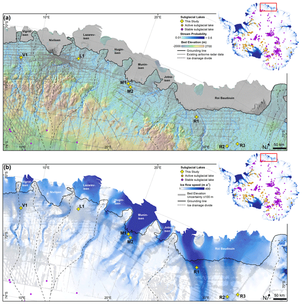
Lakes can form beneath the large ice sheets and can influence ice-sheet dynamics and stability. Some of these subglacial lakes are active, meaning that they periodically drain and refill. Here we report seven new active subglacial lakes close to the Antarctic Ice Sheet margin using satellite measurements of ice surface height changes in a region where little was known previously. These findings improve our understanding of subglacial hydrology and will help refine subglacial hydrological models.
Maria T. Kappelsberger, Martin Horwath, Eric Buchta, Matthias O. Willen, Ludwig Schröder, Sanne B. M. Veldhuijsen, Peter Kuipers Munneke, and Michiel R. van den Broeke
The Cryosphere, 18, 4355–4378, https://doi.org/10.5194/tc-18-4355-2024, https://doi.org/10.5194/tc-18-4355-2024, 2024
Short summary
Short summary
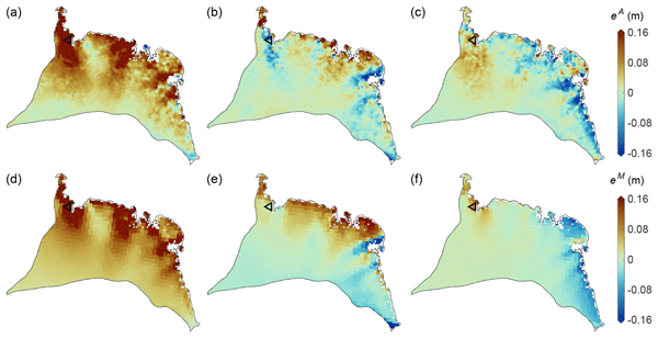
The interannual variations in the height of the Antarctic Ice Sheet (AIS) are mainly due to natural variations in snowfall. Precise knowledge of these variations is important for the detection of any long-term climatic trends in AIS surface elevation. We present a new product that spatially resolves these height variations over the period 1992–2017. The product combines the strengths of atmospheric modeling results and satellite altimetry measurements.
Christiaan T. van Dalum, Willem Jan van de Berg, Srinidhi N. Gadde, Maurice van Tiggelen, Tijmen van der Drift, Erik van Meijgaard, Lambertus H. van Ulft, and Michiel R. van den Broeke
The Cryosphere, 18, 4065–4088, https://doi.org/10.5194/tc-18-4065-2024, https://doi.org/10.5194/tc-18-4065-2024, 2024
Short summary
Short summary
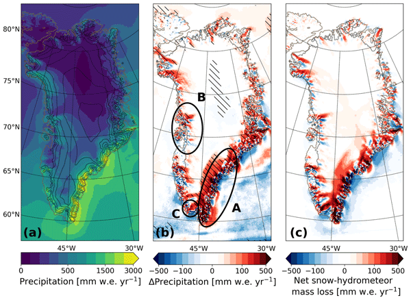
We present a new version of the polar Regional Atmospheric Climate Model (RACMO), version 2.4p1, and show first results for Greenland, Antarctica and the Arctic. We provide an overview of all changes and investigate the impact that they have on the climate of polar regions. By comparing the results with observations and the output from the previous model version, we show that the model performs well regarding the surface mass balance of the ice sheets and near-surface climate.
Gabriela Collao-Barrios, Ted A. Scambos, Christian T. Wild, Martin Truffer, Karen E. Alley, and Erin C. Pettit
EGUsphere, https://doi.org/10.5194/egusphere-2024-1895, https://doi.org/10.5194/egusphere-2024-1895, 2024
Preprint archived
Short summary
Short summary
Destabilization of ice shelves frequently leads to significant acceleration and greater mass loss, affecting rates of sea level rise. Our results show a relation between tides, flow direction, and grounding-zone acceleration that result from changing stresses in the ice margins and around a nunatak in Dotson Ice Shelf. The study describes a new way tides can influence ice shelf dynamics, an effect that could become more common as ice shelves thin and weaken around Antarctica.
Sanne B. M. Veldhuijsen, Willem Jan van de Berg, Peter Kuipers Munneke, and Michiel R. van den Broeke
The Cryosphere, 18, 1983–1999, https://doi.org/10.5194/tc-18-1983-2024, https://doi.org/10.5194/tc-18-1983-2024, 2024
Short summary
Short summary
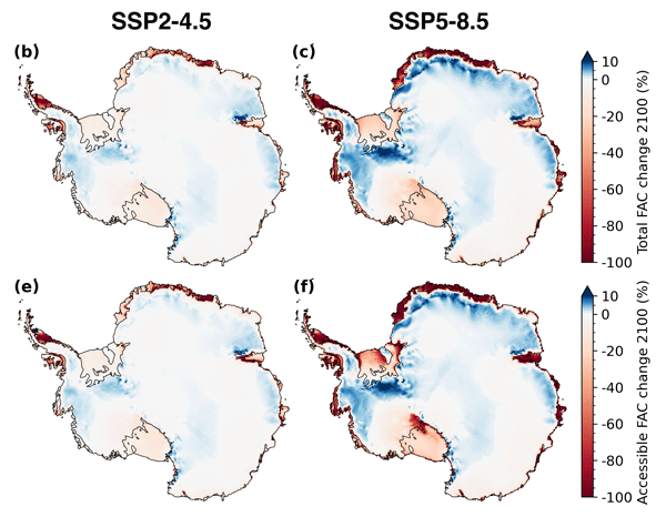
We use the IMAU firn densification model to simulate the 21st-century evolution of Antarctic firn air content. Ice shelves on the Antarctic Peninsula and the Roi Baudouin Ice Shelf in Dronning Maud Land are particularly vulnerable to total firn air content (FAC) depletion. Our results also underline the potentially large vulnerability of low-accumulation ice shelves to firn air depletion through ice slab formation.
Naomi E. Ochwat, Ted A. Scambos, Alison F. Banwell, Robert S. Anderson, Michelle L. Maclennan, Ghislain Picard, Julia A. Shates, Sebastian Marinsek, Liliana Margonari, Martin Truffer, and Erin C. Pettit
The Cryosphere, 18, 1709–1731, https://doi.org/10.5194/tc-18-1709-2024, https://doi.org/10.5194/tc-18-1709-2024, 2024
Short summary
Short summary
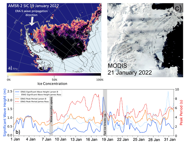
On the Antarctic Peninsula, there is a small bay that had sea ice fastened to the shoreline (
fast ice) for over a decade. The fast ice stabilized the glaciers that fed into the ocean. In January 2022, the fast ice broke away. Using satellite data we found that this was because of low sea ice concentrations and a high long-period ocean wave swell. We find that the glaciers have responded to this event by thinning, speeding up, and retreating by breaking off lots of icebergs at remarkable rates.
Brian Menounos, Alex Gardner, Caitlyn Florentine, and Andrew Fountain
The Cryosphere, 18, 889–894, https://doi.org/10.5194/tc-18-889-2024, https://doi.org/10.5194/tc-18-889-2024, 2024
Short summary
Short summary
Glaciers in western North American outside of Alaska are often overlooked in global studies because their potential to contribute to changes in sea level is small. Nonetheless, these glaciers represent important sources of freshwater, especially during times of drought. We show that these glaciers lost mass at a rate of about 12 Gt yr-1 for about the period 2013–2021; the rate of mass loss over the period 2018–2022 was similar.
Baptiste Vandecrux, Robert S. Fausto, Jason E. Box, Federico Covi, Regine Hock, Åsa K. Rennermalm, Achim Heilig, Jakob Abermann, Dirk van As, Elisa Bjerre, Xavier Fettweis, Paul C. J. P. Smeets, Peter Kuipers Munneke, Michiel R. van den Broeke, Max Brils, Peter L. Langen, Ruth Mottram, and Andreas P. Ahlstrøm
The Cryosphere, 18, 609–631, https://doi.org/10.5194/tc-18-609-2024, https://doi.org/10.5194/tc-18-609-2024, 2024
Short summary
Short summary
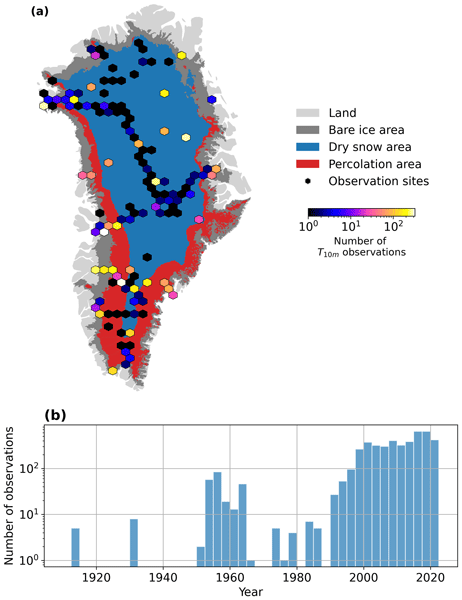
How fast is the Greenland ice sheet warming? In this study, we compiled 4500+ temperature measurements at 10 m below the ice sheet surface (T10m) from 1912 to 2022. We trained a machine learning model on these data and reconstructed T10m for the ice sheet during 1950–2022. After a slight cooling during 1950–1985, the ice sheet warmed at a rate of 0.7 °C per decade until 2022. Climate models showed mixed results compared to our observations and underestimated the warming in key regions.
Youngmin Choi, Helene Seroussi, Mathieu Morlighem, Nicole-Jeanne Schlegel, and Alex Gardner
The Cryosphere, 17, 5499–5517, https://doi.org/10.5194/tc-17-5499-2023, https://doi.org/10.5194/tc-17-5499-2023, 2023
Short summary
Short summary
Ice sheet models are often initialized using snapshot observations of present-day conditions, but this approach has limitations in capturing the transient evolution of the system. To more accurately represent the accelerating changes in glaciers, we employed time-dependent data assimilation. We found that models calibrated with the transient data better capture past trends and more accurately reproduce changes after the calibration period, even with limited observations.
Lena G. Buth, Valeria Di Biase, Peter Kuipers Munneke, Stef Lhermitte, Sanne B. M. Veldhuijsen, Sophie de Roda Husman, Michiel R. van den Broeke, and Bert Wouters
EGUsphere, https://doi.org/10.5194/egusphere-2023-2000, https://doi.org/10.5194/egusphere-2023-2000, 2023
Preprint archived
Short summary
Short summary
Liquid meltwater which is stored in air bubbles in the compacted snow near the surface of Antarctica can affect ice shelf stability. In order to detect the presence of such firn aquifers over large scales, satellite remote sensing is needed. In this paper, we present our new detection method using radar satellite data as well as the results for the whole Antarctic Peninsula. Firn aquifers are found in the north and northwest of the peninsula, in agreement with locations predicted by models.
Fernando S. Paolo, Alex S. Gardner, Chad A. Greene, Johan Nilsson, Michael P. Schodlok, Nicole-Jeanne Schlegel, and Helen A. Fricker
The Cryosphere, 17, 3409–3433, https://doi.org/10.5194/tc-17-3409-2023, https://doi.org/10.5194/tc-17-3409-2023, 2023
Short summary
Short summary
We report on a slowdown in the rate of thinning and melting of West Antarctic ice shelves. We present a comprehensive assessment of the Antarctic ice shelves, where we analyze at a continental scale the changes in thickness, flow, and basal melt over the past 26 years. We also present a novel method to estimate ice shelf change from satellite altimetry and a time-dependent data set of ice shelf thickness and basal melt rates at an unprecedented resolution.
Alex S. Gardner, Nicole-Jeanne Schlegel, and Eric Larour
Geosci. Model Dev., 16, 2277–2302, https://doi.org/10.5194/gmd-16-2277-2023, https://doi.org/10.5194/gmd-16-2277-2023, 2023
Short summary
Short summary
This is the first description of the open-source Glacier Energy and Mass Balance (GEMB) model. GEMB models the ice sheet and glacier surface–atmospheric energy and mass exchange, as well as the firn state. The model is evaluated against the current state of the art and in situ observations and is shown to perform well.
Inès N. Otosaka, Andrew Shepherd, Erik R. Ivins, Nicole-Jeanne Schlegel, Charles Amory, Michiel R. van den Broeke, Martin Horwath, Ian Joughin, Michalea D. King, Gerhard Krinner, Sophie Nowicki, Anthony J. Payne, Eric Rignot, Ted Scambos, Karen M. Simon, Benjamin E. Smith, Louise S. Sørensen, Isabella Velicogna, Pippa L. Whitehouse, Geruo A, Cécile Agosta, Andreas P. Ahlstrøm, Alejandro Blazquez, William Colgan, Marcus E. Engdahl, Xavier Fettweis, Rene Forsberg, Hubert Gallée, Alex Gardner, Lin Gilbert, Noel Gourmelen, Andreas Groh, Brian C. Gunter, Christopher Harig, Veit Helm, Shfaqat Abbas Khan, Christoph Kittel, Hannes Konrad, Peter L. Langen, Benoit S. Lecavalier, Chia-Chun Liang, Bryant D. Loomis, Malcolm McMillan, Daniele Melini, Sebastian H. Mernild, Ruth Mottram, Jeremie Mouginot, Johan Nilsson, Brice Noël, Mark E. Pattle, William R. Peltier, Nadege Pie, Mònica Roca, Ingo Sasgen, Himanshu V. Save, Ki-Weon Seo, Bernd Scheuchl, Ernst J. O. Schrama, Ludwig Schröder, Sebastian B. Simonsen, Thomas Slater, Giorgio Spada, Tyler C. Sutterley, Bramha Dutt Vishwakarma, Jan Melchior van Wessem, David Wiese, Wouter van der Wal, and Bert Wouters
Earth Syst. Sci. Data, 15, 1597–1616, https://doi.org/10.5194/essd-15-1597-2023, https://doi.org/10.5194/essd-15-1597-2023, 2023
Short summary
Short summary
By measuring changes in the volume, gravitational attraction, and ice flow of Greenland and Antarctica from space, we can monitor their mass gain and loss over time. Here, we present a new record of the Earth’s polar ice sheet mass balance produced by aggregating 50 satellite-based estimates of ice sheet mass change. This new assessment shows that the ice sheets have lost (7.5 x 10¹²) t of ice between 1992 and 2020, contributing 21 mm to sea level rise.

Sanne B. M. Veldhuijsen, Willem Jan van de Berg, Max Brils, Peter Kuipers Munneke, and Michiel R. van den Broeke
The Cryosphere, 17, 1675–1696, https://doi.org/10.5194/tc-17-1675-2023, https://doi.org/10.5194/tc-17-1675-2023, 2023
Short summary
Short summary
Firn is the transition of snow to glacier ice and covers 99 % of the Antarctic ice sheet. Knowledge about the firn layer and its variability is important, as it impacts satellite-based estimates of ice sheet mass change. Also, firn contains pores in which nearly all of the surface melt is retained. Here, we improve a semi-empirical firn model and simulate the firn characteristics for the period 1979–2020. We evaluate the performance with field and satellite measures and test its sensitivity.
Michelle L. Maclennan, Jan T. M. Lenaerts, Christine A. Shields, Andrew O. Hoffman, Nander Wever, Megan Thompson-Munson, Andrew C. Winters, Erin C. Pettit, Theodore A. Scambos, and Jonathan D. Wille
The Cryosphere, 17, 865–881, https://doi.org/10.5194/tc-17-865-2023, https://doi.org/10.5194/tc-17-865-2023, 2023
Short summary
Short summary
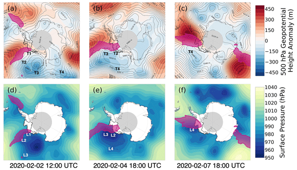
Atmospheric rivers are air masses that transport large amounts of moisture and heat towards the poles. Here, we use a combination of weather observations and models to quantify the amount of snowfall caused by atmospheric rivers in West Antarctica which is about 10 % of the total snowfall each year. We then examine a unique event that occurred in early February 2020, when three atmospheric rivers made landfall over West Antarctica in rapid succession, leading to heavy snowfall and surface melt.
Anirudha Mahagaonkar, Geir Moholdt, and Thomas V. Schuler
The Cryosphere Discuss., https://doi.org/10.5194/tc-2023-4, https://doi.org/10.5194/tc-2023-4, 2023
Revised manuscript not accepted
Short summary
Short summary
Surface meltwater lakes along the margins of the Antarctic Ice Sheet can be important for ice shelf dynamics and stability. We used optical satellite imagery to study seasonal evolution of meltwater lakes in Dronning Maud Land. We found large interannual variability in lake extents, but with consistent seasonal patterns. Although correlation with summer air temperature was strong locally, other climatic and environmental factors need to be considered to explain the large regional variability.
Marte G. Hofsteenge, Nicolas J. Cullen, Carleen H. Reijmer, Michiel van den Broeke, Marwan Katurji, and John F. Orwin
The Cryosphere, 16, 5041–5059, https://doi.org/10.5194/tc-16-5041-2022, https://doi.org/10.5194/tc-16-5041-2022, 2022
Short summary
Short summary
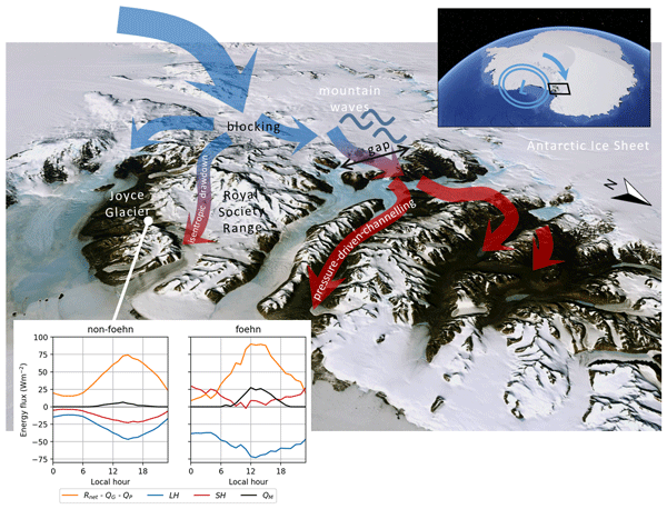
In the McMurdo Dry Valleys (MDV), foehn winds can impact glacial meltwater production and the fragile ecosystem that depends on it. We study these dry and warm winds at Joyce Glacier and show they are caused by a different mechanism than that found for nearby valleys, demonstrating the complex interaction of large-scale winds with the mountains in the MDV. We find that foehn winds increase sublimation of ice, increase heating from the atmosphere, and increase the occurrence and rates of melt.
Yang Lei, Alex S. Gardner, and Piyush Agram
Earth Syst. Sci. Data, 14, 5111–5137, https://doi.org/10.5194/essd-14-5111-2022, https://doi.org/10.5194/essd-14-5111-2022, 2022
Short summary
Short summary
This work describes NASA MEaSUREs ITS_LIVE project's Version 2 Sentinel-1 image-pair ice velocity product and processing methodology. We show the refined offset tracking algorithm, autoRIFT, calibration for Sentinel-1 geolocation biases and correction of the ionosphere streaking problems. Validation was performed over three typical test sites covering the globe by comparing with other similar global and regional products.
Lena G. Buth, Bert Wouters, Sanne B. M. Veldhuijsen, Stef Lhermitte, Peter Kuipers Munneke, and Michiel R. van den Broeke
The Cryosphere Discuss., https://doi.org/10.5194/tc-2022-127, https://doi.org/10.5194/tc-2022-127, 2022
Manuscript not accepted for further review
Short summary
Short summary
Liquid meltwater which is stored in air bubbles in the compacted snow near the surface of Antarctica can affect ice shelf stability. In order to detect the presence of such firn aquifers over large scales, satellite remote sensing is needed. In this paper, we present our new detection method using radar satellite data as well as the results for the whole Antarctic Peninsula. Firn aquifers are found in the north and northwest of the peninsula, in agreement with locations predicted by models.
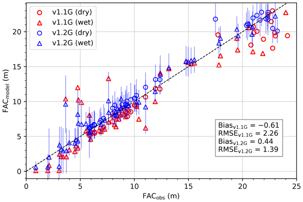
Max Brils, Peter Kuipers Munneke, Willem Jan van de Berg, and Michiel van den Broeke
Geosci. Model Dev., 15, 7121–7138, https://doi.org/10.5194/gmd-15-7121-2022, https://doi.org/10.5194/gmd-15-7121-2022, 2022
Short summary
Short summary
Firn covers the Greenland ice sheet (GrIS) and can temporarily prevent mass loss. Here, we present the latest version of our firn model, IMAU-FDM, with an application to the GrIS. We improved the density of fallen snow, the firn densification rate and the firn's thermal conductivity. This leads to a higher air content and 10 m temperatures. Furthermore we investigate three case studies and find that the updated model shows greater variability and an increased sensitivity in surface elevation.
Sophie Goliber, Taryn Black, Ginny Catania, James M. Lea, Helene Olsen, Daniel Cheng, Suzanne Bevan, Anders Bjørk, Charlie Bunce, Stephen Brough, J. Rachel Carr, Tom Cowton, Alex Gardner, Dominik Fahrner, Emily Hill, Ian Joughin, Niels J. Korsgaard, Adrian Luckman, Twila Moon, Tavi Murray, Andrew Sole, Michael Wood, and Enze Zhang
The Cryosphere, 16, 3215–3233, https://doi.org/10.5194/tc-16-3215-2022, https://doi.org/10.5194/tc-16-3215-2022, 2022
Short summary
Short summary
Terminus traces have been used to understand how Greenland's glaciers have changed over time; however, manual digitization is time-intensive, and a lack of coordination leads to duplication of efforts. We have compiled a dataset of over 39 000 terminus traces for 278 glaciers for scientific and machine learning applications. We also provide an overview of an updated version of the Google Earth Engine Digitization Tool (GEEDiT), which has been developed specifically for the Greenland Ice Sheet.
Johan Nilsson, Alex S. Gardner, and Fernando S. Paolo
Earth Syst. Sci. Data, 14, 3573–3598, https://doi.org/10.5194/essd-14-3573-2022, https://doi.org/10.5194/essd-14-3573-2022, 2022
Short summary
Short summary
The longest observational record available to study the mass balance of the Earth’s ice sheets comes from satellite altimeters. This record consists of multiple satellite missions with different measurements and quality, and it must be cross-calibrated and integrated into a consistent record for scientific use. Here, we present a novel approach for generating such a record providing a seamless record of elevation change for the Antarctic Ice Sheet that spans the period 1985 to 2020.

Joseph A. MacGregor, Winnie Chu, William T. Colgan, Mark A. Fahnestock, Denis Felikson, Nanna B. Karlsson, Sophie M. J. Nowicki, and Michael Studinger
The Cryosphere, 16, 3033–3049, https://doi.org/10.5194/tc-16-3033-2022, https://doi.org/10.5194/tc-16-3033-2022, 2022
Short summary
Short summary
Where the bottom of the Greenland Ice Sheet is frozen and where it is thawed is not well known, yet knowing this state is increasingly important to interpret modern changes in ice flow there. We produced a second synthesis of knowledge of the basal thermal state of the ice sheet using airborne and satellite observations and numerical models. About one-third of the ice sheet’s bed is likely thawed; two-fifths is likely frozen; and the remainder is too uncertain to specify.
Chloe A. Whicker, Mark G. Flanner, Cheng Dang, Charles S. Zender, Joseph M. Cook, and Alex S. Gardner
The Cryosphere, 16, 1197–1220, https://doi.org/10.5194/tc-16-1197-2022, https://doi.org/10.5194/tc-16-1197-2022, 2022
Short summary
Short summary
Snow and ice surfaces are important to the global climate. Current climate models use measurements to determine the reflectivity of ice. This model uses physical properties to determine the reflectivity of snow, ice, and darkly pigmented impurities that reside within the snow and ice. Therefore, the modeled reflectivity is more accurate for snow/ice columns under varying climate conditions. This model paves the way for improvements in the portrayal of snow and ice within global climate models.
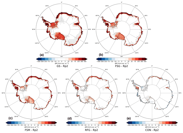
Christiaan T. van Dalum, Willem Jan van de Berg, and Michiel R. van den Broeke
The Cryosphere, 16, 1071–1089, https://doi.org/10.5194/tc-16-1071-2022, https://doi.org/10.5194/tc-16-1071-2022, 2022
Short summary
Short summary
In this study, we improve the regional climate model RACMO2 and investigate the climate of Antarctica. We have implemented a new radiative transfer and snow albedo scheme and do several sensitivity experiments. When fully tuned, the results compare well with observations and snow temperature profiles improve. Moreover, small changes in the albedo and the investigated processes can lead to a strong overestimation of melt, locally leading to runoff and a reduced surface mass balance.
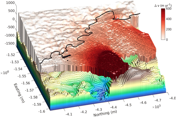
Christian T. Wild, Karen E. Alley, Atsuhiro Muto, Martin Truffer, Ted A. Scambos, and Erin C. Pettit
The Cryosphere, 16, 397–417, https://doi.org/10.5194/tc-16-397-2022, https://doi.org/10.5194/tc-16-397-2022, 2022
Short summary
Short summary
Thwaites Glacier has the potential to significantly raise Antarctica's contribution to global sea-level rise by the end of this century. Here, we use satellite measurements of surface elevation to show that its floating part is close to losing contact with an underwater ridge that currently acts to stabilize. We then use computer models of ice flow to simulate the predicted unpinning, which show that accelerated ice discharge into the ocean follows the breakup of the floating part.
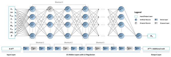
Zhongyang Hu, Peter Kuipers Munneke, Stef Lhermitte, Maaike Izeboud, and Michiel van den Broeke
The Cryosphere, 15, 5639–5658, https://doi.org/10.5194/tc-15-5639-2021, https://doi.org/10.5194/tc-15-5639-2021, 2021
Short summary
Short summary
Antarctica is shrinking, and part of the mass loss is caused by higher temperatures leading to more snowmelt. We use computer models to estimate the amount of melt, but this can be inaccurate – specifically in the areas with the most melt. This is because the model cannot account for small, darker areas like rocks or darker ice. Thus, we trained a computer using artificial intelligence and satellite images that showed these darker areas. The model computed an improved estimate of melt.
Karen E. Alley, Christian T. Wild, Adrian Luckman, Ted A. Scambos, Martin Truffer, Erin C. Pettit, Atsuhiro Muto, Bruce Wallin, Marin Klinger, Tyler Sutterley, Sarah F. Child, Cyrus Hulen, Jan T. M. Lenaerts, Michelle Maclennan, Eric Keenan, and Devon Dunmire
The Cryosphere, 15, 5187–5203, https://doi.org/10.5194/tc-15-5187-2021, https://doi.org/10.5194/tc-15-5187-2021, 2021
Short summary
Short summary
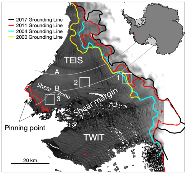
We present a 20-year, satellite-based record of velocity and thickness change on the Thwaites Eastern Ice Shelf (TEIS), the largest remaining floating extension of Thwaites Glacier (TG). TG holds the single greatest control on sea-level rise over the next few centuries, so it is important to understand changes on the TEIS, which controls much of TG's flow into the ocean. Our results suggest that the TEIS is progressively destabilizing and is likely to disintegrate over the next few decades.
Kenneth D. Mankoff, Xavier Fettweis, Peter L. Langen, Martin Stendel, Kristian K. Kjeldsen, Nanna B. Karlsson, Brice Noël, Michiel R. van den Broeke, Anne Solgaard, William Colgan, Jason E. Box, Sebastian B. Simonsen, Michalea D. King, Andreas P. Ahlstrøm, Signe Bech Andersen, and Robert S. Fausto
Earth Syst. Sci. Data, 13, 5001–5025, https://doi.org/10.5194/essd-13-5001-2021, https://doi.org/10.5194/essd-13-5001-2021, 2021
Short summary
Short summary
We estimate the daily mass balance and its components (surface, marine, and basal mass balance) for the Greenland ice sheet. Our time series begins in 1840 and has annual resolution through 1985 and then daily from 1986 through next week. Results are operational (updated daily) and provided for the entire ice sheet or by commonly used regions or sectors. This is the first input–output mass balance estimate to include the basal mass balance.
Cited articles
Allison, I. and Hyland, G.: Amery Ice Shelf compiled and merged ice thickness datasets, Australian Antarctic Data Centre, Metadata, available at: https://data.aad.gov.au/metadata/records/AIS_thickness_bottom (last access: 1 June 2016), 2010 (updated 2014).
Berthier, E., Scambos, T. A., and Shuman, C. A.: Mass loss of Larsen B tributary glaciers (Antarctic Peninsula) unabated since 2002, Geophys. Res. Lett., 39, L13501, https://doi.org/10.1029/2012GL051755, 2012.
Bindschadler, R. A. and Scambos, T. A.: Satellite-image-derived velocity field of an Antarctic ice stream, Science, 252, 242–246, 1991.
Bindschadler, R. A., Nowicki, S., Abe-Ouchi, A., Aschwanden, A., Choi, H., Fastook, J., Granzow, G., Greve, R., Gutowski, G., Herzfeld, U., Jackson, C., Johnson, J., Khroulev, C., Levermann, A., Lipscomb, W. H., Martin, M. A., Morlighem, M., Parizek, B. R., Pollard, D., Price, S. F., Ren, D., Saito, F., Sato, T., Seddik, H., Seroussi, H., Takahashi, K., Walker, R., and Wang, W. L.: Ice-sheet model sensitivities to environmental forcing and their use in projecting future sea level (the SeaRISE project), J. Glaciol., 59, 195–224, https://doi.org/10.3189/2013JoG12J125, 2013.
Blankenship, D. D., Kempf, S. D., and Young, D. A.: IceBridge HiCARS 2 L2 Geolocated Ice Thickness, Version 1, edited, NASA National Snow and Ice Data Center, Boulder, Colorado, USA, https://doi.org/10.5067/9EBR2T0VXUDG, 2012 (updated 2015).
Boening, C., Lebsock, M., Landerer, F., and Stephens, G.: Snowfall-driven mass change on the East Antarctic ice sheet, Geophys. Res. Lett., 39, L21501, https://doi.org/10.1029/2012GL053316, 2012.
Bouzinac, C.: CryoSat Product Handbook, edited, European Space Agency, available at: https://earth.esa.int/documents/10174/125272/CryoSat_Product_Handbook (last access: 1 June 2016), 2015.
Callens, D., Matsuoka, K., Steinhage, D., Smith, B., Witrant, E., and Pattyn, F.: Transition of flow regime along a marine-terminating outlet glacier in East Antarctica, The Cryosphere, 8, 867–875, https://doi.org/10.5194/tc-8-867-2014, 2014.
Callens, D., Thonnard, N., Lenaerts, J. T. M., Van Wessem, J. M., Van De Berg, W. J., Matsuoka, K., and Pattyn, F.: Mass balance of the Sør Rondane glacial system, East Antarctica, Ann. Glaciol., 56, 63–69, https://doi.org/10.3189/2015AoG70A010, 2015.
Christie, F. D. W., Bingham, R. G., Gourmelen, N., Tett, S. F. B., and Muto, A.: Four-decade record of pervasive grounding line retreat along the Bellingshausen margin of West Antarctica, Geophys. Res. Lett., 43, 5741–5749, https://doi.org/10.1002/2016GL068972, 2016.
Chuter, S. J., Martín-Español, A., Wouters, B., and Bamber, J. L.: Mass balance reassessment of glaciers draining into the Abbot and Getz Ice Shelves of West Antarctica, Geophys. Res. Lett., 44, 7328–7337, https://doi.org/10.1002/2017GL073087, 2017.
Cuffey, K. and Paterson, W. S. B.: The physics of glaciers, xii, 693 pp., Butterworth-Heinemann/Elsevier, Amsterdam, the Netherlands, Boston, USA, 2010.
Depoorter, M. A., Bamber, J. L., Griggs, J. A., Lenaerts, J. T. M., Ligtenberg, S. R. M., van den Broeke, M. R., and Moholdt, G.: Calving fluxes and basal melt rates of Antarctic ice shelves, Nature, 502, 89–92, https://doi.org/10.1038/nature12567, 2013.
Dutrieux, P., De Rydt, J., Jenkins, A., Holland, P. R., Ha, H. K., Lee, S. H., Steig, E. J., Ding, Q., Abrahamsen, E. P., and Schröder, M.: Strong Sensitivity of Pine Island Ice-Shelf Melting to Climatic Variability, Science, 343, 174–178, https://doi.org/10.1126/science.1244341, 2014.
Enderlin, E. M., Howat, I. M., Jeong, S., Noh, M.-J., van Angelen, J. H., and van den Broeke, M. R.: An improved mass budget for the Greenland ice sheet, Geophys. Res. Lett., 41, 866–872, https://doi.org/10.1002/2013GL059010, 2014.
Fahnestock, M., Scambos, T., Moon, T., Gardner, A., Haran, T., and Klinger, M.: Rapid large-area mapping of ice flow using Landsat 8, Remote Sens. Environ., 185, 84–94, https://doi.org/10.1016/j.rse.2015.11.023, 2015.
Fahnestock, M., Scambos, T., Moon, T., Gardner, A., Haran, T., and Klinger, M.: Landsat8 Ice Speed of Antarctica, available at: ftp://ftp.nsidc.org/pub/DATASETS/nsidc0733_landsat_ice_speed_v01/ (last access: 8 February 2018), 2016.
Flament, T. and Rémy, F.: Dynamic thinning of Antarctic glaciers from along-track repeat radar altimetry, J. Glaciol., 58, 830–840, https://doi.org/10.3189/2012JoG11J118, 2012.
Fretwell, P., Pritchard, H. D., Vaughan, D. G., et al.: Bedmap2: improved ice bed, surface and thickness datasets for Antarctica, The Cryosphere, 7, 375–393, https://doi.org/10.5194/tc-7-375-2013, 2013.
Gardner, A. S., Moholdt, G., Cogley, J. G., Wouters, B., Arendt, A. A., Wahr, J., Berthier, E., Hock, R., Pfeffer, W. T., Kaser, G., Ligtenberg, S. R. M., Bolch, T., Sharp, M. J., Hagen, J. O., van den Broeke, M. R., and Paul, F.: A reconciled estimate of glacier contributions to sea level rise: 2003 to 2009, Science, 340, 852–857, https://doi.org/10.1126/science.1234532, 2013.
Gardner, A. S., Moholdt, G., Scambos, T., Fahnstock, M., Ligtenberg, S., van den Broeke, M., and Nilsson, J.: Grounding Line for Antarctic Discharge (GLAD) point files for flux estimates, available at: ftp://ftp.nsidc.org/pub/DATASETS/nsidc0732_landsat_antarctic_ice_velocities_v01/GardnerEtAl_2018_SupData/GLAD_flux_gates/, last access: 8 February 2018a.
Gardner, A. S., Moholdt, G., Scambos, T., Fahnstock, M., Ligtenberg, S., van den Broeke, M., and Nilsson, J.: JPL auto-RIFT v0.1 surface velocities, available at: ftp://ftp.nsidc.org/pub/DATASETS/nsidc0732_landsat_antarctic_ice_velocities_v01/GardnerEtAl_2018_SupData/GLAD_flux_gates/, last access: 8 February 2018b.
Gogineni, P.: CReSIS Radar Depth Sounder Data, edited, Lawrence, Kansas, USA, avaialble at: http://data.cresis.ku.edu/ (last access: 1 June 2016), 2012 (updated 2015).
Harig, C. and Simons, F. J.: Accelerated West Antarctic ice mass loss continues to outpace East Antarctic gains, Earth Planet. Sc. Lett., 415, 134–141, https://doi.org/10.1016/j.epsl.2015.01.029, 2015.
Helm, V., Humbert, A., and Miller, H.: Elevation and elevation change of Greenland and Antarctica derived from CryoSat-2, The Cryosphere, 8, 1539–1559, https://doi.org/10.5194/tc-8-1539-2014, 2014.
Hogg, A. E., Shepherd, A., Cornford, S. L., Briggs, K. H., Gourmelen, N., Graham, J. A., Joughin, I., Mouginot, J., Nagler, T., Payne, A. J., Rignot, E., and Wuite, J.: Increased ice flow in Western Palmer Land linked to ocean melting, Geophys. Res. Lett., 44, 4159–4167, https://doi.org/10.1002/2016GL072110, 2017.
Hulbe, C. L., Scambos, T. A., Klinger, M., and Fahnestock, M. A.: Flow variability and ongoing margin shifts on Bindschadler and MacAyeal Ice Streams, West Antarctica, J. Geophys. Res.-Earth, 121, 283–293, https://doi.org/10.1002/2015JF003670, 2016.
Huss, M. and Farinotti, D.: A high-resolution bedrock map for the Antarctic Peninsula, The Cryosphere, 8, 1261–1273, https://doi.org/10.5194/tc-8-1261-2014, 2014.
Jacobs, S., Giulivi, C., Dutrieux, P., Rignot, E., Nitsche, F., and Mouginot, J.: Getz Ice Shelf melting response to changes in ocean forcing, J. Geophys. Res.-Oceans, 118, 4152–4168, https://doi.org/10.1002/jgrc.20298, 2013.
Jacobs, S. S., Hellmer, H. H., and Jenkins, A.: Antarctic Ice Sheet melting in the southeast Pacific, Geophys. Res. Lett., 23, 957–960, https://doi.org/10.1029/96GL00723, 1996.
Jacobs, S. S., Jenkins, A., Giulivi, C. F., and Dutrieux, P.: Stronger ocean circulation and increased melting under Pine Island Glacier ice shelf, Supplement, Nat. Geosci., 4, 519–523, https://doi.org/10.1038/ngeo1188, 2011.
Jenkins, A., Vaughan, D. G., Jacobs, S. S., Hellmer, H. H., and Keys, J. R.: Glaciological and oceanographic evidence of high melt rates beneath Pine Island Glacier, West Antarctica, J. Glaciol., 43, 114–121, 1997.
Jeong, S. and Howat, I. M.: Performance of Landsat 8 Operational Land Imager for mapping ice sheet velocity, Remote Sens. Environ., 170, 90–101, https://doi.org/10.1016/j.rse.2015.08.023, 2015.
Jezek, K. C., Farness, K., Carande, R., Wu, X., and Labelle-Hamer, N.: RADARSAT 1 synthetic aperture radar observations of Antarctica: Modified Antarctic Mapping Mission, 2000, Radio Sci., 38, 8067, https://doi.org/10.1029/2002RS002643, 2003.
Khazendar, A., Borstad, C. P., Scheuchl, B., Rignot, E., and Seroussi, H.: The evolving instability of the remnant Larsen B Ice Shelf and its tributary glaciers, Earth Planet. Sc. Lett., 419, 199–210, https://doi.org/10.1016/j.epsl.2015.03.014, 2015.
Khazendar, A., Rignot, E., Schroeder, D. M., Seroussi, H., Schodlok, M. P., Scheuchl, B., Mouginot, J., Sutterley, T. C., and Velicogna, I.: Rapid submarine ice melting in the grounding zones of ice shelves in West Antarctica, Supplement, Nat. Commun., 7, 13243, https://doi.org/10.1038/ncomms13243, 2016.
King, M. A., Bingham, R. J., Moore, P., Whitehouse, P. L., Bentley, M. J., and Milne, G. A.: Lower satellite-gravimetry estimates of Antarctic sea-level contribution, Supplement, Nature, 491, 586–589, https://doi.org/10.1038/nature11621, 2012.
Konrad, H., Gilbert, L., Cornford, S. L., Payne, A., Hogg, A., Muir, A., and Shepherd, A.: Uneven onset and pace of ice-dynamical imbalance in the Amundsen Sea Embayment, West Antarctica, Geophys. Res. Lett., 44, 910–918, https://doi.org/10.1002/2016GL070733, 2017.
Leuschen, C., Gogineni, P., Rodriguez-Morales, F., Paden, J., and Allen, C.: IceBridge MCoRDS L2 Ice Thickness, Version 1, edited, NASA National Snow and Ice Data Center, Boulder, Colorado, USA, https://doi.org/10.5067/GDQ0CUCVTE2Q, 2010 (updated 2015).
Li, X., Rignot, E., Morlighem, M., Mouginot, J., and Scheuchl, B.: Grounding line retreat of Totten Glacier, East Antarctica, 1996 to 2013, Geophys. Res. Lett., 42, 8049–8056, https://doi.org/10.1002/2015GL065701, 2015.
Li, X., Rignot, E., Mouginot, J., and Scheuchl, B.: Ice flow dynamics and mass loss of Totten Glacier, East Antarctica, from 1989 to 2015, Geophys. Res. Lett., 43, 6366–6373, https://doi.org/10.1002/2016GL069173, 2016.
Ligtenberg, S. R. M., Helsen, M. M., and van den Broeke, M. R.: An improved semi-empirical model for the densification of Antarctic firn, The Cryosphere, 5, 809–819, https://doi.org/10.5194/tc-5-809-2011, 2011.
Ligtenberg, S. R. M., Kuipers Munneke, P., and van den Broeke, M. R.: Present and future variations in Antarctic firn air content, The Cryosphere, 8, 1711–1723, https://doi.org/10.5194/tc-8-1711-2014, 2014.
Macgregor, J. A., Catania, G. A., Markowski, M. S., and Andrews, A. G.: Widespread rifting and retreat of ice-shelf margins in the eastern Amundsen Sea Embayment between 1972 and 2011, J. Glaciol., 58, 458–466, https://doi.org/10.3189/2012JoG11J262, 2012.
Martín-Español, A., Zammit-Mangion, A., Clarke, P. J., Flament, T., Helm, V., King, M. A., Luthcke, S. B., Petrie, E., Rémy, F., Schön, N., Wouters, B., and. Bamber, J. L: Spatial and temporal Antarctic Ice Sheet mass trends, glacio-isostatic adjustment, and surface processes from a joint inversion of satellite altimeter, gravity, and GPS data, J. Geophys. Res.-Earth, 121, 182–200, https://doi.org/10.1002/2015JF003550, 2016.
McMillan, M., Shepherd, A., Sundal, A., Briggs, K., Muir, A., Ridout, A., Hogg, A., and Wingham, D.: Increased ice losses from Antarctica detected by CryoSat-2, Geophys. Res. Lett., 41, 3899–3905, https://doi.org/10.1002/2014GL060111, 2014.
Morlighem, M., Rignot, E., Seroussi, H., Larour, E., Ben Dhia, H., and Aubry, D.: A mass conservation approach for mapping glacier ice thickness, Geophys. Res. Lett., 38, L19503, https://doi.org/10.1029/2011GL048659, 2011.
Mouginot, J., Rignot, E., and Scheuchl, B.: Sustained increase in ice discharge from the Amundsen Sea Embayment, West Antarctica, from 1973 to 2013, Geophys. Res. Lett., 41, 1576–1584, https://doi.org/10.1002/2013GL059069, 2014.
Mouginot, J., Rignot, E., Scheuchl, B., and Millan, R.: Comprehensive Annual Ice Sheet Velocity Mapping Using Landsat-8, Sentinel-1, and RADARSAT-2 Data, Remote Sensing, 9, 364, https://doi.org/10.3390/rs9040364, 2017.
Nilsson, J., Gardner, A., Sandberg Sørensen, L., and Forsberg, R.: Improved retrieval of land ice topography from CryoSat-2 data and its impact for volume-change estimation of the Greenland Ice Sheet, The Cryosphere, 10, 2953–2969, https://doi.org/10.5194/tc-10-2953-2016, 2016.
Padman, L., Erofeeva, S. Y., and Fricker, H. A.: Improving Antarctic tide models by assimilation of ICESat laser altimetry over ice shelves, Geophys. Res. Lett., 35, L22504, https://doi.org/10.1029/2008GL035592, 2008.
Paolo, F. S., Fricker, H. A., and Padman, L.: Volume loss from Antarctic ice shelves is accelerating, Science, 348, 327–331, https://doi.org/10.1126/science.aaa0940, 2015.
Paragios, N., Chen, Y., and Faugeras, O. D.: Handbook of mathematical models in computer vision, Springer Science & Business Media, New York, NY, USA, 2006.
Pattyn, F.: Antarctic subglacial conditions inferred from a hybrid ice sheet/ice stream model, Earth Planet. Sc. Lett., 295, 451–461, https://doi.org/10.1016/j.epsl.2010.04.025, 2010.
Pritchard, H. D., Arthern, R. J., Vaughan, D. G., and Edwards, L. A.: Extensive dynamic thinning on the margins of the Greenland and Antarctic ice sheets, Nature, 461, 971–975, 2009.
Pritchard, H. D., Ligtenberg, S. R. M., Fricker, H. A., Vaughan, D. G., van den Broeke, M. R., and Padman, L.: Antarctic ice-sheet loss driven by basal melting of ice shelves, Supplement, Nature, 484, 502–505, https://doi.org/10.1038/nature10968, 2012.
Rignot, E.: Changes in ice dynamics and mass balance of the Antarctic ice sheet, Philos. T. Roy. Soc. Lond. A, 364, 1637–1655, https://doi.org/10.1098/rsta.2006.1793, 2006.
Rignot, E. and Thomas, R. H.: Mass balance of Polar ice sheets, Science, 297, 1502–1506, 2002.
Rignot, E., Mouginot, J., and Scheuchl, B.: Ice Flow of the Antarctic Ice Sheet, Science, 333, 1427–1430, https://doi.org/10.1126/science.1208336, 2011a.
Rignot, E., Velicogna, I., van den Broeke, M. R., Monaghan, A., and Lenaerts, J.: Acceleration of the contribution of the Greenland and Antarctic ice sheets to sea level rise, Geophys. Res. Lett., 38, L05503, https://doi.org/10.1029/2011gl046583, 2011b.
Rignot, E., Jacobs, S., Mouginot, J., and Scheuchl, B.: Ice-Shelf Melting Around Antarctica, Science, 341, 266–270, https://doi.org/10.1126/science.1235798, 2013.
Rignot, E., Mouginot, J., Morlighem, M., Seroussi, H., and Scheuchl, B.: Widespread, rapid grounding line retreat of Pine Island, Thwaites, Smith, and Kohler glaciers, West Antarctica, from 1992 to 2011, Geophys. Res. Lett., 41, 3502–3509, https://doi.org/10.1002/2014GL060140, 2014.
Scambos, T. A., Dutkiewicz, M. J., Wilson, J. C., and Bindschadler, R. A.: Application of Image Cross-Correlation to the Measurement of Glacier Velocity Using Satellite Image Data, Remote Sens. Environ., 42, 177–186, 1992.
Scambos, T. A., Haran, T. M., Fahnestock, M. A., Painter, T. H., and Bohlander, J.: MODIS-based Mosaic of Antarctica (MOA) data sets: Continent-wide surface morphology and snow grain size, Remote Sens. Environ., 111, 242–257, https://doi.org/10.1016/j.rse.2006.12.020, 2007.
Scambos, T. A., Berthier, E., Haran, T., Shuman, C. A., Cook, A. J., Ligtenberg, S. R. M., and Bohlander, J.: Detailed ice loss pattern in the northern Antarctic Peninsula: widespread decline driven by ice front retreats, The Cryosphere, 8, 2135–2145, https://doi.org/10.5194/tc-8-2135-2014, 2014.
Scheuchl, B., Mouginot, J., and Rignot, E.: Ice velocity changes in the Ross and Ronne sectors observed using satellite radar data from 1997 and 2009, The Cryosphere, 6, 1019–1030, https://doi.org/10.5194/tc-6-1019-2012, 2012.
Scheuchl, B., Mouginot, J., Rignot, E., Morlighem, M., and Khazendar, A.: Grounding line retreat of Pope, Smith, and Kohler Glaciers, West Antarctica, measured with Sentinel-1a radar interferometry data, Geophys. Res. Lett., 43, 8572–8579, https://doi.org/10.1002/2016GL069287, 2016.
Shepherd, A., Ivins, E. R., A, G., et al.: A Reconciled Estimate of Ice-Sheet Mass Balance, Science, 338, 1183–1189, https://doi.org/10.1126/science.1228102, 2012.
Shuman, C. A., Berthier, E., and Scambos, T. A.: 2001–2009 elevation and mass losses in the Larsen A and B embayments, Antarctic Peninsula, J. Glaciol., 57, 737–754, https://doi.org/10.3189/002214311797409811, 2017.
Smith, J. A., Andersen, T. J., Shortt, M., Gaffney, A. M., Truffer, M., Stanton, T. P., Bindschadler, R., Dutrieux, P., Jenkins, A., Hillenbrand, C. D., Ehrmann, W., Corr, H. F. J., Farley, N., Crowhurst, S., and Vaughan, D. G.: Sub-ice-shelf sediments record history of twentieth-century retreat of Pine Island Glacier, Nature, 541, 77–80, https://doi.org/10.1038/nature20136, 2017.
Snyder, J. P.: Map projections: A working manual, Report Rep. 1395, U. S. Government Printing Office, Washington, D.C, USA, 1987.
Thomson, J. and Cooper, A.: The SCAR Antarctic digital topographic database, Antarct. Sci., 5, 239–244, 1993.
Van Liefferinge, B. and Pattyn, F.: Using ice-flow models to evaluate potential sites of million year-old ice in Antarctica, Clim. Past, 9, 2335–2345, https://doi.org/10.5194/cp-9-2335-2013, 2013.
van Wessem, J. M., Reijmer, C. H., Morlighem, M., Mouginot, J., Rignot, E., Medley, B., Joughin, I., Wouters, B., Depoorter, M. A., Bamber, J. L., Lenaerts, J. T. M., De Van Berg, W. J., Van Den Broeke, M. R., and Van Meijgaard, E.: Improved representation of East Antarctic surface mass balance in a regional atmospheric climate model, J. Glaciol., 60, 761–770, https://doi.org/10.3189/2014JoG14J051, 2014.
van Wessem, J. M., Ligtenberg, S. R. M., Reijmer, C. H., van de Berg, W. J., van den Broeke, M. R., Barrand, N. E., Thomas, E. R., Turner, J., Wuite, J., Scambos, T. A., and van Meijgaard, E.: The modelled surface mass balance of the Antarctic Peninsula at 5.5 km horizontal resolution, The Cryosphere, 10, 271–285, https://doi.org/10.5194/tc-10-271-2016, 2016.
Velicogna, I.: Increasing rates of ice mass loss from the Greenland and Antarctic ice sheets revealed by GRACE, Geophys. Res. Lett., 36, L19503, https://doi.org/10.1029/2009gl040222, 2009.
Walker, C. C. and Gardner, A. S.: Rapid drawdown of Antarctica's Wordie Ice Shelf glaciers in response to ENSO/Southern Annular Mode-driven warming in the Southern Ocean, Supplement C, Earth Planet. Sc. Lett., 476, 100–110, https://doi.org/10.1016/j.epsl.2017.08.005, 2017.
Watkins, M. M., Wiese, D. N., Yuan, D.-N., Boening, C., and Landerer, F. W.: Improved methods for observing Earth's time variable mass distribution with GRACE using spherical cap mascons, J. Geophys. Res.-Sol. Ea., 120, 2648–2671, https://doi.org/10.1002/2014JB011547, 2015.
Wouters, B., Martin-Español, A., Helm, V., Flament, T., van Wessem, J. M., Ligtenberg, S. R. M., van den Broeke, M. R., and Bamber, J. L.: Dynamic thinning of glaciers on the Southern Antarctic Peninsula, Science, 348, 899–903, https://doi.org/10.1126/science.aaa5727, 2015.
Wuite, J., Rott, H., Hetzenecker, M., Floricioiu, D., De Rydt, J., Gudmundsson, G. H., Nagler, T., and Kern, M.: Evolution of surface velocities and ice discharge of Larsen B outlet glaciers from 1995 to 2013, The Cryosphere, 9, 957–969, https://doi.org/10.5194/tc-9-957-2015, 2015.
Zwally, H. J., Giovinetto, B. M., Beckley, M. A., and Saba, J. L.: Antarctic and Greenland Drainage Systems, GSFC Cryospheric Sciences Laboratory, available at: http://icesat4.gsfc.nasa.gov/cryo_data/ant_grn_drainage_systems.php (last access: 1 June 2016), 2002.
Short summary
We map present-day Antarctic surface velocities from Landsat imagery and compare to earlier estimates from radar. Flow accelerations across the grounding lines of West Antarctica's Amundsen Sea Embayment, Getz Ice Shelf and the western Antarctic Peninsula, account for 89 % of the observed increase in ice discharge. In contrast, glaciers draining the East Antarctic have been remarkably stable. Our work suggests that patterns of mass loss are part of a longer-term phase of enhanced flow.
We map present-day Antarctic surface velocities from Landsat imagery and compare to earlier...


