
Articles | Volume 11, issue 3
https://doi.org/10.5194/tc-11-1327-2017
© Author(s) 2017. This work is distributed under
the Creative Commons Attribution 3.0 License.
the Creative Commons Attribution 3.0 License.
https://doi.org/10.5194/tc-11-1327-2017
© Author(s) 2017. This work is distributed under
the Creative Commons Attribution 3.0 License.
the Creative Commons Attribution 3.0 License.
Brief communication
| 
06 Jun 2017
Brief communication |
| 06 Jun 2017
Brief communication: The global signature of post-1900 land ice wastage on vertical land motion
Riccardo E. M. Riva
CORRESPONDING AUTHOR
Department Geoscience and Remote Sensing, Delft University of
Technology, Delft, 2618 CN, the Netherlands
Thomas Frederikse
Department Geoscience and Remote Sensing, Delft University of
Technology, Delft, 2618 CN, the Netherlands
Matt A. King
Surveying and Spatial Sciences, School of Land and Food, University of
Tasmania, Hobart, Tasmania, Australia
Ben Marzeion
Institute of Geography, University of Bremen, Bremen, Germany
Michiel R. van den Broeke
Institute for Marine and Atmospheric Research Utrecht, Utrecht
University, Utrecht, the Netherlands
Related authors
Mattia Poinelli, Michael Schodlok, Eric Larour, Miren Vizcaino, and Riccardo Riva
The Cryosphere, 17, 2261–2283, https://doi.org/10.5194/tc-17-2261-2023, https://doi.org/10.5194/tc-17-2261-2023, 2023
Short summary
Short summary
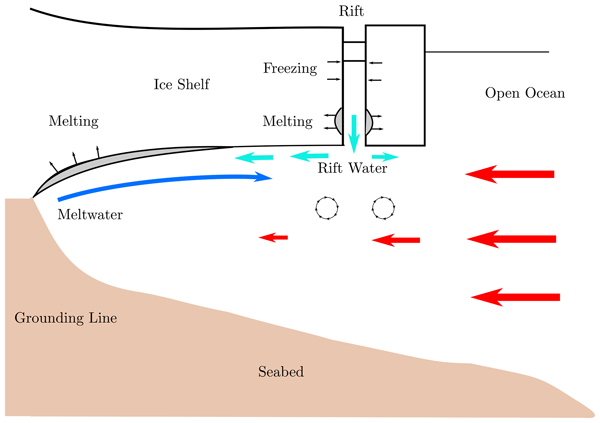
Rifts are fractures on ice shelves that connect the ice on top to the ocean below. The impact of rifts on ocean circulation below Antarctic ice shelves has been largely unexplored as ocean models are commonly run at resolutions that are too coarse to resolve the presence of rifts. Our model simulations show that a kilometer-wide rift near the ice-shelf front modulates heat intrusion beneath the ice and inhibits basal melt. These processes are therefore worthy of further investigation.
Carolina M. L. Camargo, Riccardo E. M. Riva, Tim H. J. Hermans, Eike M. Schütt, Marta Marcos, Ismael Hernandez-Carrasco, and Aimée B. A. Slangen
Ocean Sci., 19, 17–41, https://doi.org/10.5194/os-19-17-2023, https://doi.org/10.5194/os-19-17-2023, 2023
Short summary
Short summary
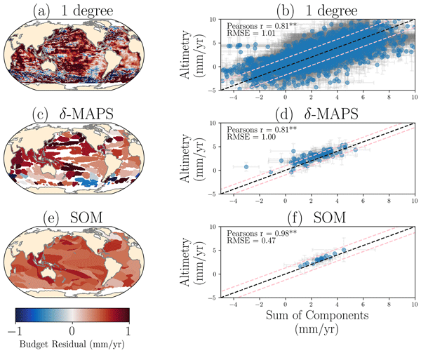
Sea-level change is mainly caused by variations in the ocean’s temperature and salinity and land ice melting. Here, we quantify the contribution of the different drivers to the regional sea-level change. We apply machine learning techniques to identify regions that have similar sea-level variability. These regions reduce the observational uncertainty that has limited the regional sea-level budget so far and highlight how large-scale ocean circulation controls regional sea-level change.
Carolina M. L. Camargo, Riccardo E. M. Riva, Tim H. J. Hermans, and Aimée B. A. Slangen
Earth Syst. Dynam., 13, 1351–1375, https://doi.org/10.5194/esd-13-1351-2022, https://doi.org/10.5194/esd-13-1351-2022, 2022
Short summary
Short summary
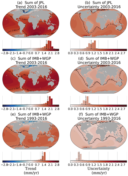
The mass loss from Antarctica, Greenland and glaciers and variations in land water storage cause sea-level changes. Here, we characterize the regional trends within these sea-level contributions, taking into account mass variations since 1993. We take a comprehensive approach to determining the uncertainties of these sea-level changes, considering different types of errors. Our study reveals the importance of clearly quantifying the uncertainties of sea-level change trends.
Jenan Rajavarathan, Matt King, Christopher Watson, and Nicolaj Hansen
The Cryosphere, 20, 5099–5113, https://doi.org/10.5194/tc-20-5099-2026, https://doi.org/10.5194/tc-20-5099-2026, 2026
Short summary
Short summary
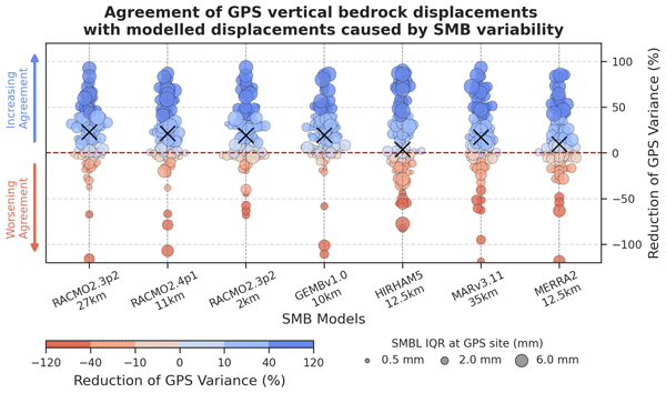
Antarctic surface mass balance (SMB) is a source of major uncertainty in ice-sheet mass balance estimates, but its evaluation remains limited. We introduce a novel method using continuous, bedrock-fixed GPS vertical displacements as a spatially integrated constraint on low-frequency SMB variability over hundreds of kilometres. Applied across Antarctica, it reveals systematic, region-dependent differences with modelled SMB-driven displacements, guiding SMB model refinement.
Marte Gé Hofsteenge, Willem Jan van de Berg, Christiaan van Dalum, Kristiina Verro, Maurice van Tiggelen, and Michiel van den Broeke
The Cryosphere, 20, 4747–4766, https://doi.org/10.5194/tc-20-4747-2026, https://doi.org/10.5194/tc-20-4747-2026, 2026
Short summary
Short summary
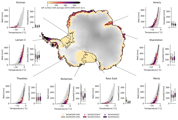
We use a regional climate model to study how surface melt on Antarctic ice shelves responds to air temperature. The relationship is strongly non-linear, mainly due to feedbacks in surface albedo, with other energy sources also contributing. Currently colder, drier, and more stable ice shelves will experience more melt at the same temperature than ice shelves in wetter climates, highlighting their vulnerability to fracturing, ice shelf instability, and contributions to global sea-level rise.
Sanne B. M. Veldhuijsen, Peter Kuipers Munneke, Willem Jan van de Berg, Michiel R. van den Broeke, and Luke D. Trusel
EGUsphere, https://doi.org/10.5194/egusphere-2026-3453, https://doi.org/10.5194/egusphere-2026-3453, 2026
This preprint is open for discussion and under review for The Cryosphere (TC).
Short summary
Short summary
Antarctica has floating ice shelves around its perimeter that provide stability to the ice sheet. As temperature rises, snow on the ice shelves may melt away, and ponding of meltwater may cause the ice shelves to collapse. If that happens, Antarctica may start to lose ice faster than before, resulting in accelerated sea-level rise. The tool presented in this article will be used in simulations of future climate to determine when climate change leads to collapse of the ice shelves in Antarctica.
Xiaojun Ma, Matt King, Jonathan Bamber, Bin Liu, Wenke Sun, and Qiuyu Wang
EGUsphere, https://doi.org/10.5194/egusphere-2026-3461, https://doi.org/10.5194/egusphere-2026-3461, 2026
This preprint is open for discussion and under review for The Cryosphere (TC).
Short summary
Short summary
Satellite records of glacier change are only about two decades long, so short-term climate swings can strongly affect estimated trends. Using satellite gravity data, we show that the largest year-to-year changes in global glacier mass come from the Arctic and are linked to the North Atlantic Oscillation and Pacific Decadal Oscillation. Accounting for these effects makes Alaska’s estimated ice loss about one-third larger, improving interpretation of glacier change and future sea-level rise.
Fredrik Boberg, Xavier Fettweis, Nicolaj Hansen, Ruth Mottram, and Michiel R. van den Broeke
The Cryosphere, 20, 2947–2960, https://doi.org/10.5194/tc-20-2947-2026, https://doi.org/10.5194/tc-20-2947-2026, 2026
Short summary
Short summary
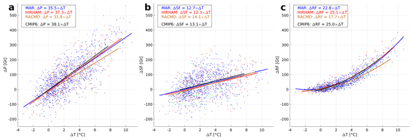
An ensemble of regional climate model simulations is used to estimate the 21st century change in precipitation on the Greenland ice sheet. For the end of the century, the change is in the range 40 to 170 Gt per year, depending on the emission scenario. Using annual values of 2 m air temperature and precipitation, we estimate an increase in precipitation of 35 Gt per year for every degree of warming.
Samuel M. Tax, Maurice van Tiggelen, Thirza N. Feenstra, Paul C. J. P. Smeets, Srinidhi N. Gadde, Christiaan T. van Dalum, Willem Jan van de Berg, and Michiel R. van den Broeke
EGUsphere, https://doi.org/10.5194/egusphere-2026-1926, https://doi.org/10.5194/egusphere-2026-1926, 2026
Short summary
Short summary
Strong winds can lift snow into the air, which influences the energy exchange between the surface and the atmosphere. We studied this phenomenon over the Greenland Ice Sheet using observations and a climate model. We found that blowing snow traps heat near the surface like a blanket and reflects incoming sunlight like a mirror. Simulating these processes increases the net energy at the surface and improves model accuracy. Therefore, we recommend including these effects in climate models.
Mirko Scheinert, Weisen Shen, Richard C. Aster, Lambert Caron, Michael D. Hartinger, Matt A. King, Andrew Lloyd, Anya M. Reading, J. Paul Winberry, Terry Wilson, Lucilla Alfonsi, Michael J. Bentley, Eric Buchta, Thomas Y. Chen, Peter J. Clarke, Jörg Ebbing, Olaf Eisen, Natalya Gomez, Esra Günaydın, Samantha Hansen, Erik R. Ivins, Achraf Koulali, Grace A. Nield, Frederick Richards, Mahmut O. Selbesoglu, Stephanie Sherman, Pippa L. Whitehouse, and Matthias Willen
EGUsphere, https://doi.org/10.5194/egusphere-2025-6370, https://doi.org/10.5194/egusphere-2025-6370, 2026
Short summary
Short summary
With an ongoing mass loss the Antarctic Ice Sheet contributes to global-mean sea level rise at a rate of 0.4 mm/a. Thus, it plays a key role in global climate and provides a natural laboratory to study processes that interlink cryosphere, solid Earth, atmosphere and ocean. We discuss how GNSS and seismic networks in Antarctica were used to significantly advance our understanding of these processes, and how they should be maintained and extended to answer key science questions in the future.
Benjamin Heurgue, Charles Amory, Christoph Kittel, Fredrik Boberg, Gaël Durand, Vincent Favier, Xavier Fettweis, Quentin Glaude, Heiko Goelzer, Nicolaj Hansen, Nicolas C. Jourdain, Ruth Mottram, Martin Olesen, Willem Jan Van de Berg, Michiel R. Van den Broeke, and René R. Wijngaard
EGUsphere, https://doi.org/10.5194/egusphere-2026-624, https://doi.org/10.5194/egusphere-2026-624, 2026
Short summary
Short summary
We studied how the Antarctic ice sheet surface mass balance may change by 2100 using three high-resolution climate models forced by the same future climate scenario. While the models agree for present-day conditions, they project very different futures, especially over floating ice shelves. These differences mainly come from how melting, refreezing, and temperature are represented. Our results show that future sea level projections strongly depend on how well models simulate today’s climate.
Tesse E. A. van den Aker, Peter Kuipers Munneke, Willem Jan van de Berg, Walter W. Immerzeel, and Michiel R. van den Broeke
EGUsphere, https://doi.org/10.5194/egusphere-2026-462, https://doi.org/10.5194/egusphere-2026-462, 2026
Short summary
Short summary
The firn layer, i.e. permanent snow, regulates how an ice sheet responds to climate change. Firn models are forced with with climate data at time steps from sub-daily to annual in literature, however, implications are barely evaluated. We test the impact of different climate forcing time steps on the modeled firn layer. We conclude that the climate forcing time step (1) affects firn model output, (2) can lead to non-physical behaviour, and (3) that resolving at least a diurnal cycle is required.
Thirza N. Feenstra, Willem Jan van de Berg, Gerd-Jan van Zadelhoff, David P. Donovan, Christiaan T. van Dalum, and Michiel R. van den Broeke
Atmos. Meas. Tech., 19, 1323–1344, https://doi.org/10.5194/amt-19-1323-2026, https://doi.org/10.5194/amt-19-1323-2026, 2026
Short summary
Short summary
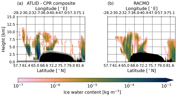
Cloud representation brings large uncertainties in polar climate modeling. We show the first evaluation of Greenland clouds in the Regional Atmospheric Climate Model (RACMO2.4) with new EarthCARE satellite data. Comparing lidar and radar observations and retrieved cloud profiles with co-located RACMO output, we find RACMO captures low ice clouds but underestimates high clouds, mid-altitude liquid clouds, and snowfall. These results highlight EarthCARE's potential to improve polar climate models.
John Bright Ayabilah, Matt King, Danielle Udy, and Tessa Vance
The Cryosphere, 20, 1237–1255, https://doi.org/10.5194/tc-20-1237-2026, https://doi.org/10.5194/tc-20-1237-2026, 2026
Short summary
Short summary
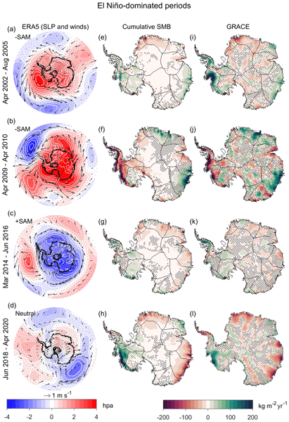
Large-scale climate modes significantly influence Antarctic Ice Sheet (AIS) mass variability. This study investigates AIS variability during different El Niño-Southern Oscillation (ENSO) periods using GRACE data (2002–2022). Results show strong spatial variability driven by changes in the Amundsen Sea Low (ASL) and Southern Annular Mode (SAM). This highlights the importance of understanding these patterns for future ice mass estimates and sea level rise predictions.
Muhammad Shafeeque, Jan-Hendrik Malles, Anouk Vlug, Marco Möller, and Ben Marzeion
The Cryosphere, 20, 875–903, https://doi.org/10.5194/tc-20-875-2026, https://doi.org/10.5194/tc-20-875-2026, 2026
Short summary
Short summary
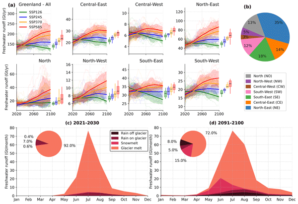
This study projects Greenland's peripheral glaciers' response to climate change using the Open Global Glacier Model (OGGM). They may lose up to 52 % of ice mass by 2100. We predict changes in ice discharge versus melting, affecting fjords, sea levels, and ocean currents. Freshwater runoff composition and peak water timing vary by region and scenario. Our findings highlight the importance of reducing emissions to minimize impacts on these glaciers and their influence on ecosystems.
Ida Haven, Hans Christian Steen-Larsen, Laura J. Dietrich, Sonja Wahl, Jason E. Box, Michiel R. van den Broeke, Alun Hubbard, Stephan T. Kral, Joachim Reuder, and Maurice van Tiggelen
The Cryosphere, 20, 573–593, https://doi.org/10.5194/tc-20-573-2026, https://doi.org/10.5194/tc-20-573-2026, 2026
Short summary
Short summary
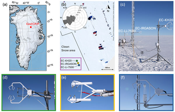
Three independent Eddy-Covariance measurement systems deployed on top of the Greenland Ice Sheet are compared. Using this dataset, we evaluate the reproducibility and quantify the differences between the systems. The fidelity of two regional climate models in capturing the seasonal variability in the latent and sensible heat flux between the snow surface and the atmosphere is assessed. We identify differences between observations and model simulations, especially during the winter period.

Horst Machguth, Andrew Tedstone, Peter Kuipers Munneke, Max Brils, Brice Noël, Nicole Clerx, Nicolas Jullien, Xavier Fettweis, and Michiel van den Broeke
The Cryosphere, 20, 427–452, https://doi.org/10.5194/tc-20-427-2026, https://doi.org/10.5194/tc-20-427-2026, 2026
Short summary
Short summary
Due to increasing air temperatures, surface melt expands to higher elevations on the Greenland ice sheet. This is visible on satellite imagery in the form of rivers of meltwater running across the surface of the ice sheet. We compare model results of meltwater at high elevations on the ice sheet to satellite observations. We find that each of the models shows strengths and weaknesses. A detailed look into the model results reveals potential reasons for the differences between models.
Valeria Di Biase, Peter Kuipers Munneke, Bert Wouters, Michiel R. van den Broeke, and Maurice van Tiggelen
The Cryosphere, 20, 87–96, https://doi.org/10.5194/tc-20-87-2026, https://doi.org/10.5194/tc-20-87-2026, 2026
Short summary
Short summary
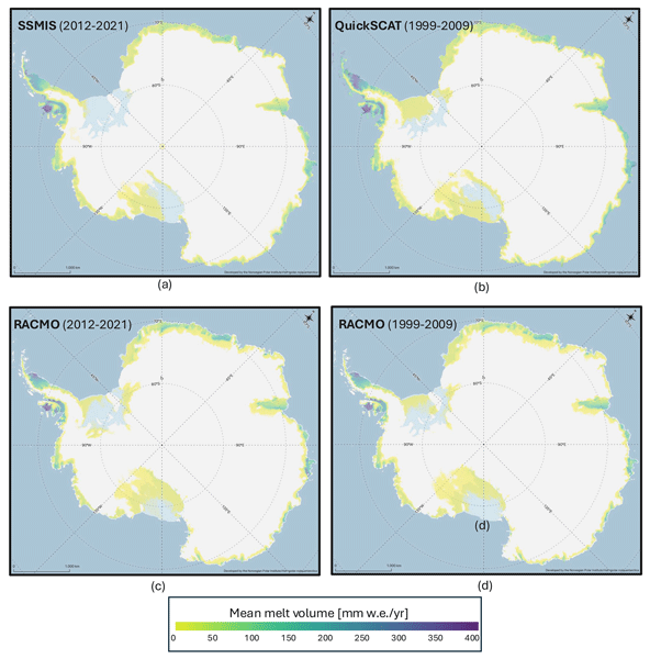
We produce annual maps of Antarctic surface melt volumes from 2012 to 2021 using satellite microwave data. We detect melting days from thresholds on the satellite signal and then use actual melt measurements from weather stations to convert those signals into water‑equivalent volumes. Our maps capture known melt hotspots and show slightly lower totals than climate models. This dataset supports climate and ice‑shelf studies.

Heiko Goelzer, Constantijn J. Berends, Fredrik Boberg, Gael Durand, Tamsin L. Edwards, Xavier Fettweis, Fabien Gillet-Chaulet, Quentin Glaude, Philippe Huybrechts, Sébastien Le clec'h, Ruth Mottram, Brice Noël, Martin Olesen, Charlotte Rahlves, Jeremy Rohmer, Michiel van den Broeke, and Roderik S. W. van de Wal
The Cryosphere, 19, 6887–6906, https://doi.org/10.5194/tc-19-6887-2025, https://doi.org/10.5194/tc-19-6887-2025, 2025
Short summary
Short summary
We present an ensemble of ice sheet model projections for the Greenland ice sheet. The focus is on providing projections that improve our understanding of the range future sea-level rise and the inherent uncertainties over the next 100 to 300 years. Compared to earlier work we more fully account for some of the uncertainties in sea-level projections. We include a wider range of climate model output, more climate change scenarios and we extend projections schematically up to year 2300.
Sanne B. M. Veldhuijsen, Willem Jan van de Berg, Peter Kuipers Munneke, Nicolaj Hansen, Fredrik Boberg, Christoph Kittel, Charles Amory, and Michiel R. van den Broeke
The Cryosphere, 19, 5157–5173, https://doi.org/10.5194/tc-19-5157-2025, https://doi.org/10.5194/tc-19-5157-2025, 2025
Short summary
Short summary
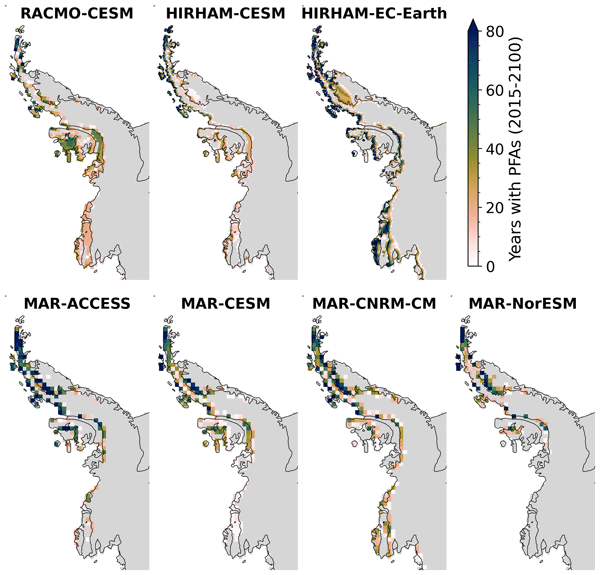
Perennial firn aquifers (PFAs), year-round bodies of liquid water within firns, can potentially impact ice-shelf and ice-sheet stability. We developed a fast XGBoost firn emulator to predict the 21st-century distribution of PFAs in Antarctica for 12 climatic forcing datasets. Our findings suggest that, in low-emission scenarios, PFAs remain confined to the Antarctic Peninsula. However, in a high-emission scenario, PFAs are projected to expand to a region in West Antarctica and East Antarctica.
Christiaan T. van Dalum, Willem Jan van de Berg, Michiel R. van den Broeke, and Maurice van Tiggelen
The Cryosphere, 19, 4061–4090, https://doi.org/10.5194/tc-19-4061-2025, https://doi.org/10.5194/tc-19-4061-2025, 2025
Short summary
Short summary
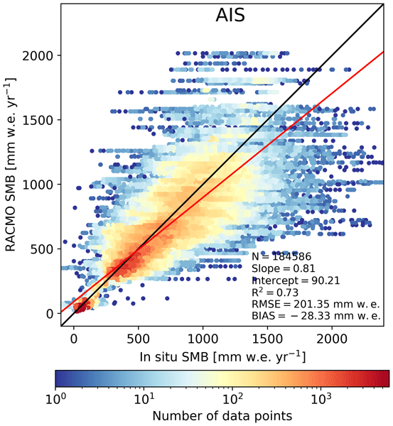
In this study, we present a new surface mass balance (SMB) and near-surface climate product for Antarctica with the regional climate model RACMO2.4p1. We assess the impact of major model updates on the climate of Antarctica. Locally, the SMB has changed substantially but also agrees well with observations. In addition, we show that the SMB components, surface energy budget, albedo, pressure, temperature, and wind speed compare well with in situ and remote sensing observations.
Maurice van Tiggelen, Paul C. J. P. Smeets, Carleen H. Reijmer, Peter Kuipers Munneke, and Michiel R. van den Broeke
Earth Syst. Sci. Data, 17, 4933–4955, https://doi.org/10.5194/essd-17-4933-2025, https://doi.org/10.5194/essd-17-4933-2025, 2025
Short summary
Short summary
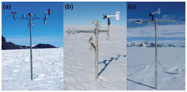
This paper describes the measurements from the 19 IMAU (Institute for Marine and Atmospheric research Utrecht) automatic weather stations that operated on the Antarctic ice sheet from 1995 through 2022. These stations also measured the net surface radiation and surface height change, allowing for the quantification of the surface energy and mass balance at hourly resolution. These data are invaluable for the evaluation of atmospheric models and for the detection of climatological changes.
Anneke L. Vries, Willem Jan van de Berg, Brice Noël, Lorenz Meire, and Michiel R. van den Broeke
The Cryosphere, 19, 3897–3914, https://doi.org/10.5194/tc-19-3897-2025, https://doi.org/10.5194/tc-19-3897-2025, 2025
Short summary
Short summary
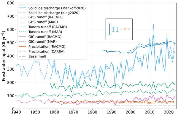
Freshwater flows into Greenland's fjords from various sources. Solid ice discharge (e.g. calving icebergs) dominates freshwater input in the southeast and northwest. In contrast, in the southwest, runoff from the ice sheet and tundra are the most significant. Seasonal data revealed that fjord precipitation and tundra runoff contribute up to 11 % and 35 % of the monthly freshwater input, respectively. Our results provide valuable input for ocean models and for researchers studying fjord ecosystems.
Florentin Hofmeister, Xinyang Fan, Madlene Pfeiffer, Ben Marzeion, Bettina Schaefli, and Gabriele Chiogna
EGUsphere, https://doi.org/10.5194/egusphere-2025-3256, https://doi.org/10.5194/egusphere-2025-3256, 2025
Short summary
Short summary
We use the WRF model for dynamically downscaling a global reanalysis product for the period 1850 to 2015 for the central European Alps. We demonstrate a workflow for transferring coarse-resolution (2 km) WRF temperature and precipitation to a much finer spatial resolution (25 m) of a physics-based hydrological model (WaSiM) and evaluate the results in a multi-data approach covering different simulation periods. Our results highlight the need for plausible and consistent elevation gradients.
Shfaqat A. Khan, Helene Seroussi, Mathieu Morlighem, William Colgan, Veit Helm, Gong Cheng, Danjal Berg, Valentina R. Barletta, Nicolaj K. Larsen, William Kochtitzky, Michiel van den Broeke, Kurt H. Kjær, Andy Aschwanden, Brice Noël, Jason E. Box, Joseph A. MacGregor, Robert S. Fausto, Kenneth D. Mankoff, Ian M. Howat, Kuba Oniszk, Dominik Fahrner, Anja Løkkegaard, Eigil Y. H. Lippert, Alicia Bråtner, and Javed Hassan
Earth Syst. Sci. Data, 17, 3047–3071, https://doi.org/10.5194/essd-17-3047-2025, https://doi.org/10.5194/essd-17-3047-2025, 2025
Short summary
Short summary
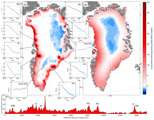
The surface elevation of the Greenland Ice Sheet is changing due to surface mass balance processes and ice dynamics, each exhibiting distinct spatiotemporal patterns. Here, we employ satellite and airborne altimetry data with fine spatial (1 km) and temporal (monthly) resolutions to document this spatiotemporal evolution from 2003 to 2023. This dataset of fine-resolution altimetry data in both space and time will support studies of ice mass loss and be useful for GIS ice sheet modeling.
Torsten Kanzow, Angelika Humbert, Thomas Mölg, Mirko Scheinert, Matthias Braun, Hans Burchard, Francesca Doglioni, Philipp Hochreuther, Martin Horwath, Oliver Huhn, Maria Kappelsberger, Jürgen Kusche, Erik Loebel, Katrina Lutz, Ben Marzeion, Rebecca McPherson, Mahdi Mohammadi-Aragh, Marco Möller, Carolyne Pickler, Markus Reinert, Monika Rhein, Martin Rückamp, Janin Schaffer, Muhammad Shafeeque, Sophie Stolzenberger, Ralph Timmermann, Jenny Turton, Claudia Wekerle, and Ole Zeising
The Cryosphere, 19, 1789–1824, https://doi.org/10.5194/tc-19-1789-2025, https://doi.org/10.5194/tc-19-1789-2025, 2025
Short summary
Short summary
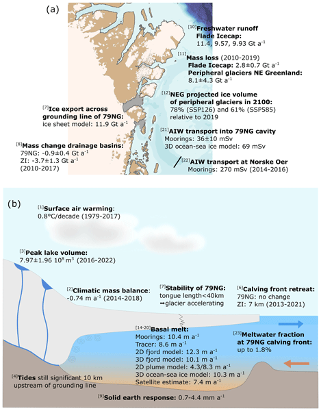
The Greenland Ice Sheet represents the second-largest contributor to global sea-level rise. We quantify atmosphere, ice and ocean processes related to the mass balance of glaciers in northeast Greenland, focusing on Greenland’s largest floating ice tongue, the 79° N Glacier. We find that together, the different in situ and remote sensing observations and model simulations reveal a consistent picture of a coupled atmosphere–ice sheet–ocean system that has entered a phase of major change.
Eric Buchta, Mirko Scheinert, Matt A. King, Terry Wilson, Achraf Koulali, Peter J. Clarke, Demián Gómez, Eric Kendrick, Christoph Knöfel, and Peter Busch
Earth Syst. Sci. Data, 17, 1761–1780, https://doi.org/10.5194/essd-17-1761-2025, https://doi.org/10.5194/essd-17-1761-2025, 2025
Short summary
Short summary
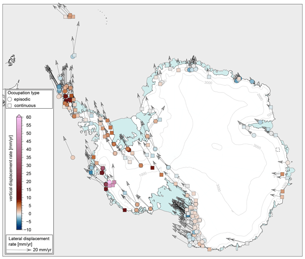
Geodetic GPS measurements in Antarctica have been used to track bedrock displacement, which is vital for understanding geodynamic processes such as plate motion and glacial isostatic adjustment. However, the potential of GPS data has been limited by its partially fragmented availability and unreliable metadata. A new dataset, which spans the period from 1995 to 2021, offers consistently processed coordinate time series for 286 GPS sites and promises to enhance future geodynamic research.
Jan-Hendrik Malles, Ben Marzeion, and Paul G. Myers
Earth Syst. Dynam., 16, 347–377, https://doi.org/10.5194/esd-16-347-2025, https://doi.org/10.5194/esd-16-347-2025, 2025
Short summary
Short summary
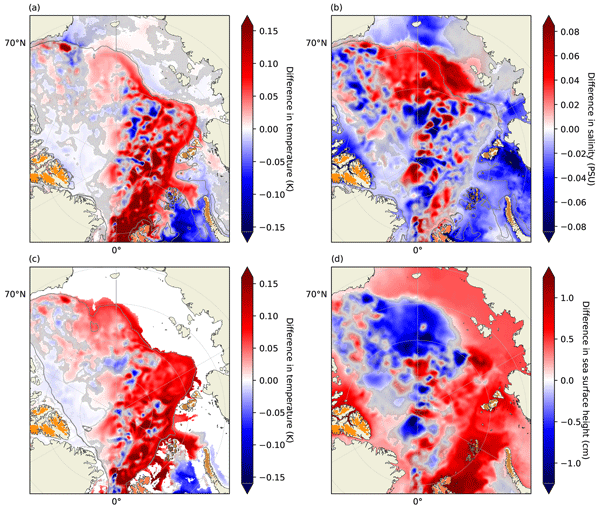
Glaciers in the high-latitude Northern Hemisphere (outside Greenland) are losing mass at roughly half the Greenland ice sheet's rate. Still, this is usually not included in the freshwater input data for ocean circulation models. Also, the submarine melt of glaciers (outside the ice sheets) has not been quantified yet. We tackle both issues by using a glacier model's output as additional fresh water for the ocean model and by using the ocean model's output to model submarine melt.
Harry Zekollari, Matthias Huss, Lilian Schuster, Fabien Maussion, David R. Rounce, Rodrigo Aguayo, Nicolas Champollion, Loris Compagno, Romain Hugonnet, Ben Marzeion, Seyedhamidreza Mojtabavi, and Daniel Farinotti
The Cryosphere, 18, 5045–5066, https://doi.org/10.5194/tc-18-5045-2024, https://doi.org/10.5194/tc-18-5045-2024, 2024
Short summary
Short summary
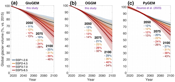
Glaciers are major contributors to sea-level rise and act as key water resources. Here, we model the global evolution of glaciers under the latest generation of climate scenarios. We show that the type of observations used for model calibration can strongly affect the projections at the local scale. Our newly projected 21st century global mass loss is higher than the current community estimate as reported in the latest Intergovernmental Panel on Climate Change (IPCC) report.
Maria T. Kappelsberger, Martin Horwath, Eric Buchta, Matthias O. Willen, Ludwig Schröder, Sanne B. M. Veldhuijsen, Peter Kuipers Munneke, and Michiel R. van den Broeke
The Cryosphere, 18, 4355–4378, https://doi.org/10.5194/tc-18-4355-2024, https://doi.org/10.5194/tc-18-4355-2024, 2024
Short summary
Short summary
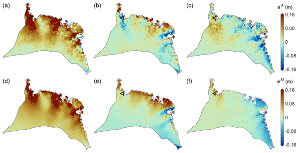
The interannual variations in the height of the Antarctic Ice Sheet (AIS) are mainly due to natural variations in snowfall. Precise knowledge of these variations is important for the detection of any long-term climatic trends in AIS surface elevation. We present a new product that spatially resolves these height variations over the period 1992–2017. The product combines the strengths of atmospheric modeling results and satellite altimetry measurements.
Christiaan T. van Dalum, Willem Jan van de Berg, Srinidhi N. Gadde, Maurice van Tiggelen, Tijmen van der Drift, Erik van Meijgaard, Lambertus H. van Ulft, and Michiel R. van den Broeke
The Cryosphere, 18, 4065–4088, https://doi.org/10.5194/tc-18-4065-2024, https://doi.org/10.5194/tc-18-4065-2024, 2024
Short summary
Short summary
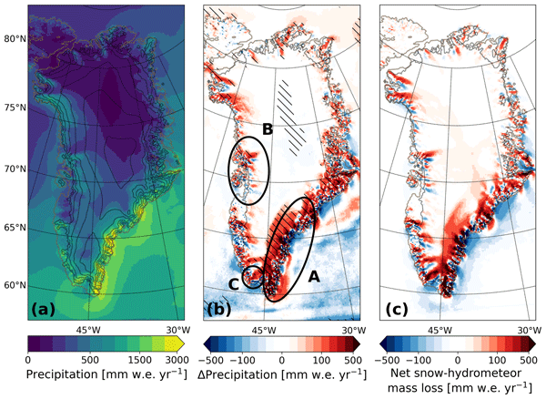
We present a new version of the polar Regional Atmospheric Climate Model (RACMO), version 2.4p1, and show first results for Greenland, Antarctica and the Arctic. We provide an overview of all changes and investigate the impact that they have on the climate of polar regions. By comparing the results with observations and the output from the previous model version, we show that the model performs well regarding the surface mass balance of the ice sheets and near-surface climate.
Sanne B. M. Veldhuijsen, Willem Jan van de Berg, Peter Kuipers Munneke, and Michiel R. van den Broeke
The Cryosphere, 18, 1983–1999, https://doi.org/10.5194/tc-18-1983-2024, https://doi.org/10.5194/tc-18-1983-2024, 2024
Short summary
Short summary
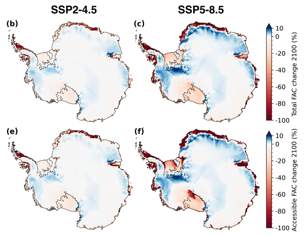
We use the IMAU firn densification model to simulate the 21st-century evolution of Antarctic firn air content. Ice shelves on the Antarctic Peninsula and the Roi Baudouin Ice Shelf in Dronning Maud Land are particularly vulnerable to total firn air content (FAC) depletion. Our results also underline the potentially large vulnerability of low-accumulation ice shelves to firn air depletion through ice slab formation.
Baptiste Vandecrux, Robert S. Fausto, Jason E. Box, Federico Covi, Regine Hock, Åsa K. Rennermalm, Achim Heilig, Jakob Abermann, Dirk van As, Elisa Bjerre, Xavier Fettweis, Paul C. J. P. Smeets, Peter Kuipers Munneke, Michiel R. van den Broeke, Max Brils, Peter L. Langen, Ruth Mottram, and Andreas P. Ahlstrøm
The Cryosphere, 18, 609–631, https://doi.org/10.5194/tc-18-609-2024, https://doi.org/10.5194/tc-18-609-2024, 2024
Short summary
Short summary
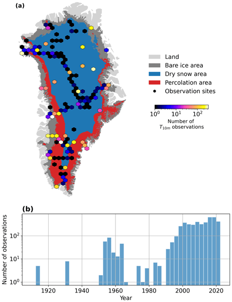
How fast is the Greenland ice sheet warming? In this study, we compiled 4500+ temperature measurements at 10 m below the ice sheet surface (T10m) from 1912 to 2022. We trained a machine learning model on these data and reconstructed T10m for the ice sheet during 1950–2022. After a slight cooling during 1950–1985, the ice sheet warmed at a rate of 0.7 °C per decade until 2022. Climate models showed mixed results compared to our observations and underestimated the warming in key regions.
Lena G. Buth, Valeria Di Biase, Peter Kuipers Munneke, Stef Lhermitte, Sanne B. M. Veldhuijsen, Sophie de Roda Husman, Michiel R. van den Broeke, and Bert Wouters
EGUsphere, https://doi.org/10.5194/egusphere-2023-2000, https://doi.org/10.5194/egusphere-2023-2000, 2023
Preprint archived
Short summary
Short summary
Liquid meltwater which is stored in air bubbles in the compacted snow near the surface of Antarctica can affect ice shelf stability. In order to detect the presence of such firn aquifers over large scales, satellite remote sensing is needed. In this paper, we present our new detection method using radar satellite data as well as the results for the whole Antarctic Peninsula. Firn aquifers are found in the north and northwest of the peninsula, in agreement with locations predicted by models.
Mattia Poinelli, Michael Schodlok, Eric Larour, Miren Vizcaino, and Riccardo Riva
The Cryosphere, 17, 2261–2283, https://doi.org/10.5194/tc-17-2261-2023, https://doi.org/10.5194/tc-17-2261-2023, 2023
Short summary
Short summary
Rifts are fractures on ice shelves that connect the ice on top to the ocean below. The impact of rifts on ocean circulation below Antarctic ice shelves has been largely unexplored as ocean models are commonly run at resolutions that are too coarse to resolve the presence of rifts. Our model simulations show that a kilometer-wide rift near the ice-shelf front modulates heat intrusion beneath the ice and inhibits basal melt. These processes are therefore worthy of further investigation.
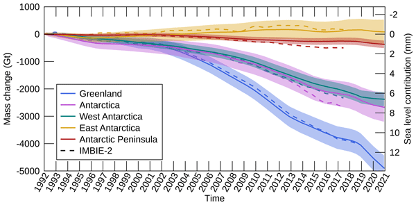
Inès N. Otosaka, Andrew Shepherd, Erik R. Ivins, Nicole-Jeanne Schlegel, Charles Amory, Michiel R. van den Broeke, Martin Horwath, Ian Joughin, Michalea D. King, Gerhard Krinner, Sophie Nowicki, Anthony J. Payne, Eric Rignot, Ted Scambos, Karen M. Simon, Benjamin E. Smith, Louise S. Sørensen, Isabella Velicogna, Pippa L. Whitehouse, Geruo A, Cécile Agosta, Andreas P. Ahlstrøm, Alejandro Blazquez, William Colgan, Marcus E. Engdahl, Xavier Fettweis, Rene Forsberg, Hubert Gallée, Alex Gardner, Lin Gilbert, Noel Gourmelen, Andreas Groh, Brian C. Gunter, Christopher Harig, Veit Helm, Shfaqat Abbas Khan, Christoph Kittel, Hannes Konrad, Peter L. Langen, Benoit S. Lecavalier, Chia-Chun Liang, Bryant D. Loomis, Malcolm McMillan, Daniele Melini, Sebastian H. Mernild, Ruth Mottram, Jeremie Mouginot, Johan Nilsson, Brice Noël, Mark E. Pattle, William R. Peltier, Nadege Pie, Mònica Roca, Ingo Sasgen, Himanshu V. Save, Ki-Weon Seo, Bernd Scheuchl, Ernst J. O. Schrama, Ludwig Schröder, Sebastian B. Simonsen, Thomas Slater, Giorgio Spada, Tyler C. Sutterley, Bramha Dutt Vishwakarma, Jan Melchior van Wessem, David Wiese, Wouter van der Wal, and Bert Wouters
Earth Syst. Sci. Data, 15, 1597–1616, https://doi.org/10.5194/essd-15-1597-2023, https://doi.org/10.5194/essd-15-1597-2023, 2023
Short summary
Short summary
By measuring changes in the volume, gravitational attraction, and ice flow of Greenland and Antarctica from space, we can monitor their mass gain and loss over time. Here, we present a new record of the Earth’s polar ice sheet mass balance produced by aggregating 50 satellite-based estimates of ice sheet mass change. This new assessment shows that the ice sheets have lost (7.5 x 10¹²) t of ice between 1992 and 2020, contributing 21 mm to sea level rise.
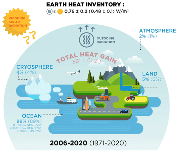
Karina von Schuckmann, Audrey Minière, Flora Gues, Francisco José Cuesta-Valero, Gottfried Kirchengast, Susheel Adusumilli, Fiammetta Straneo, Michaël Ablain, Richard P. Allan, Paul M. Barker, Hugo Beltrami, Alejandro Blazquez, Tim Boyer, Lijing Cheng, John Church, Damien Desbruyeres, Han Dolman, Catia M. Domingues, Almudena García-García, Donata Giglio, John E. Gilson, Maximilian Gorfer, Leopold Haimberger, Maria Z. Hakuba, Stefan Hendricks, Shigeki Hosoda, Gregory C. Johnson, Rachel Killick, Brian King, Nicolas Kolodziejczyk, Anton Korosov, Gerhard Krinner, Mikael Kuusela, Felix W. Landerer, Moritz Langer, Thomas Lavergne, Isobel Lawrence, Yuehua Li, John Lyman, Florence Marti, Ben Marzeion, Michael Mayer, Andrew H. MacDougall, Trevor McDougall, Didier Paolo Monselesan, Jan Nitzbon, Inès Otosaka, Jian Peng, Sarah Purkey, Dean Roemmich, Kanako Sato, Katsunari Sato, Abhishek Savita, Axel Schweiger, Andrew Shepherd, Sonia I. Seneviratne, Leon Simons, Donald A. Slater, Thomas Slater, Andrea K. Steiner, Toshio Suga, Tanguy Szekely, Wim Thiery, Mary-Louise Timmermans, Inne Vanderkelen, Susan E. Wjiffels, Tonghua Wu, and Michael Zemp
Earth Syst. Sci. Data, 15, 1675–1709, https://doi.org/10.5194/essd-15-1675-2023, https://doi.org/10.5194/essd-15-1675-2023, 2023
Short summary
Short summary
Earth's climate is out of energy balance, and this study quantifies how much heat has consequently accumulated over the past decades (ocean: 89 %, land: 6 %, cryosphere: 4 %, atmosphere: 1 %). Since 1971, this accumulated heat reached record values at an increasing pace. The Earth heat inventory provides a comprehensive view on the status and expectation of global warming, and we call for an implementation of this global climate indicator into the Paris Agreement’s Global Stocktake.

Sanne B. M. Veldhuijsen, Willem Jan van de Berg, Max Brils, Peter Kuipers Munneke, and Michiel R. van den Broeke
The Cryosphere, 17, 1675–1696, https://doi.org/10.5194/tc-17-1675-2023, https://doi.org/10.5194/tc-17-1675-2023, 2023
Short summary
Short summary
Firn is the transition of snow to glacier ice and covers 99 % of the Antarctic ice sheet. Knowledge about the firn layer and its variability is important, as it impacts satellite-based estimates of ice sheet mass change. Also, firn contains pores in which nearly all of the surface melt is retained. Here, we improve a semi-empirical firn model and simulate the firn characteristics for the period 1979–2020. We evaluate the performance with field and satellite measures and test its sensitivity.
Carolina M. L. Camargo, Riccardo E. M. Riva, Tim H. J. Hermans, Eike M. Schütt, Marta Marcos, Ismael Hernandez-Carrasco, and Aimée B. A. Slangen
Ocean Sci., 19, 17–41, https://doi.org/10.5194/os-19-17-2023, https://doi.org/10.5194/os-19-17-2023, 2023
Short summary
Short summary
Sea-level change is mainly caused by variations in the ocean’s temperature and salinity and land ice melting. Here, we quantify the contribution of the different drivers to the regional sea-level change. We apply machine learning techniques to identify regions that have similar sea-level variability. These regions reduce the observational uncertainty that has limited the regional sea-level budget so far and highlight how large-scale ocean circulation controls regional sea-level change.
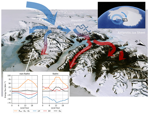
Marte G. Hofsteenge, Nicolas J. Cullen, Carleen H. Reijmer, Michiel van den Broeke, Marwan Katurji, and John F. Orwin
The Cryosphere, 16, 5041–5059, https://doi.org/10.5194/tc-16-5041-2022, https://doi.org/10.5194/tc-16-5041-2022, 2022
Short summary
Short summary
In the McMurdo Dry Valleys (MDV), foehn winds can impact glacial meltwater production and the fragile ecosystem that depends on it. We study these dry and warm winds at Joyce Glacier and show they are caused by a different mechanism than that found for nearby valleys, demonstrating the complex interaction of large-scale winds with the mountains in the MDV. We find that foehn winds increase sublimation of ice, increase heating from the atmosphere, and increase the occurrence and rates of melt.
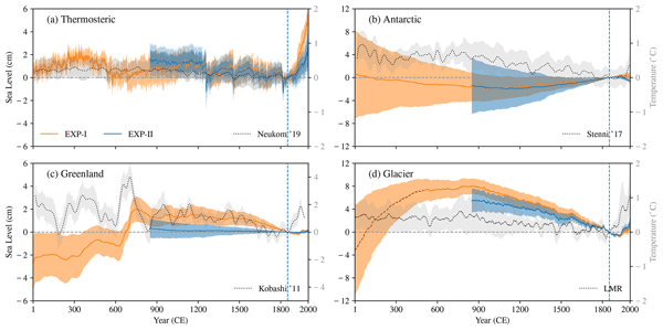
Nidheesh Gangadharan, Hugues Goosse, David Parkes, Heiko Goelzer, Fabien Maussion, and Ben Marzeion
Earth Syst. Dynam., 13, 1417–1435, https://doi.org/10.5194/esd-13-1417-2022, https://doi.org/10.5194/esd-13-1417-2022, 2022
Short summary
Short summary
We describe the contributions of ocean thermal expansion and land-ice melting (ice sheets and glaciers) to global-mean sea-level (GMSL) changes in the Common Era. The mass contributions are the major sources of GMSL changes in the pre-industrial Common Era and glaciers are the largest contributor. The paper also describes the current state of climate modelling, uncertainties and knowledge gaps along with the potential implications of the past variabilities in the contemporary sea-level rise.
Lena G. Buth, Bert Wouters, Sanne B. M. Veldhuijsen, Stef Lhermitte, Peter Kuipers Munneke, and Michiel R. van den Broeke
The Cryosphere Discuss., https://doi.org/10.5194/tc-2022-127, https://doi.org/10.5194/tc-2022-127, 2022
Manuscript not accepted for further review
Short summary
Short summary
Liquid meltwater which is stored in air bubbles in the compacted snow near the surface of Antarctica can affect ice shelf stability. In order to detect the presence of such firn aquifers over large scales, satellite remote sensing is needed. In this paper, we present our new detection method using radar satellite data as well as the results for the whole Antarctic Peninsula. Firn aquifers are found in the north and northwest of the peninsula, in agreement with locations predicted by models.
Carolina M. L. Camargo, Riccardo E. M. Riva, Tim H. J. Hermans, and Aimée B. A. Slangen
Earth Syst. Dynam., 13, 1351–1375, https://doi.org/10.5194/esd-13-1351-2022, https://doi.org/10.5194/esd-13-1351-2022, 2022
Short summary
Short summary
The mass loss from Antarctica, Greenland and glaciers and variations in land water storage cause sea-level changes. Here, we characterize the regional trends within these sea-level contributions, taking into account mass variations since 1993. We take a comprehensive approach to determining the uncertainties of these sea-level changes, considering different types of errors. Our study reveals the importance of clearly quantifying the uncertainties of sea-level change trends.
Max Brils, Peter Kuipers Munneke, Willem Jan van de Berg, and Michiel van den Broeke
Geosci. Model Dev., 15, 7121–7138, https://doi.org/10.5194/gmd-15-7121-2022, https://doi.org/10.5194/gmd-15-7121-2022, 2022
Short summary
Short summary
Firn covers the Greenland ice sheet (GrIS) and can temporarily prevent mass loss. Here, we present the latest version of our firn model, IMAU-FDM, with an application to the GrIS. We improved the density of fallen snow, the firn densification rate and the firn's thermal conductivity. This leads to a higher air content and 10 m temperatures. Furthermore we investigate three case studies and find that the updated model shows greater variability and an increased sensitivity in surface elevation.
Ole Richter, David E. Gwyther, Matt A. King, and Benjamin K. Galton-Fenzi
The Cryosphere, 16, 1409–1429, https://doi.org/10.5194/tc-16-1409-2022, https://doi.org/10.5194/tc-16-1409-2022, 2022
Short summary
Short summary
Tidal currents may play an important role in Antarctic ice sheet retreat by changing the rate at which the ocean melts glaciers. Here, using a computational ocean model, we derive the first estimate of present-day tidal melting that covers all of Antarctica. Our results suggest that large-scale ocean models aiming to accurately predict ice melt rates will need to account for the effects of tides. The inclusion of tide-induced friction at the ice–ocean interface should be prioritized.
Christiaan T. van Dalum, Willem Jan van de Berg, and Michiel R. van den Broeke
The Cryosphere, 16, 1071–1089, https://doi.org/10.5194/tc-16-1071-2022, https://doi.org/10.5194/tc-16-1071-2022, 2022
Short summary
Short summary
In this study, we improve the regional climate model RACMO2 and investigate the climate of Antarctica. We have implemented a new radiative transfer and snow albedo scheme and do several sensitivity experiments. When fully tuned, the results compare well with observations and snow temperature profiles improve. Moreover, small changes in the albedo and the investigated processes can lead to a strong overestimation of melt, locally leading to runoff and a reduced surface mass balance.
Grace A. Nield, Matt A. King, Rebekka Steffen, and Bas Blank
Geosci. Model Dev., 15, 2489–2503, https://doi.org/10.5194/gmd-15-2489-2022, https://doi.org/10.5194/gmd-15-2489-2022, 2022
Short summary
Short summary
We present a finite-element model of post-seismic solid Earth deformation built in the software package Abaqus for the purpose of calculating post-seismic deformation in the far field of major earthquakes. The model is benchmarked against an existing open-source post-seismic model demonstrating good agreement. The advantage over existing models is the potential for simple modification to include 3-D Earth structure, non-linear rheologies and alternative or multiple sources of stress change.
Martin Horwath, Benjamin D. Gutknecht, Anny Cazenave, Hindumathi Kulaiappan Palanisamy, Florence Marti, Ben Marzeion, Frank Paul, Raymond Le Bris, Anna E. Hogg, Inès Otosaka, Andrew Shepherd, Petra Döll, Denise Cáceres, Hannes Müller Schmied, Johnny A. Johannessen, Jan Even Øie Nilsen, Roshin P. Raj, René Forsberg, Louise Sandberg Sørensen, Valentina R. Barletta, Sebastian B. Simonsen, Per Knudsen, Ole Baltazar Andersen, Heidi Ranndal, Stine K. Rose, Christopher J. Merchant, Claire R. Macintosh, Karina von Schuckmann, Kristin Novotny, Andreas Groh, Marco Restano, and Jérôme Benveniste
Earth Syst. Sci. Data, 14, 411–447, https://doi.org/10.5194/essd-14-411-2022, https://doi.org/10.5194/essd-14-411-2022, 2022
Short summary
Short summary
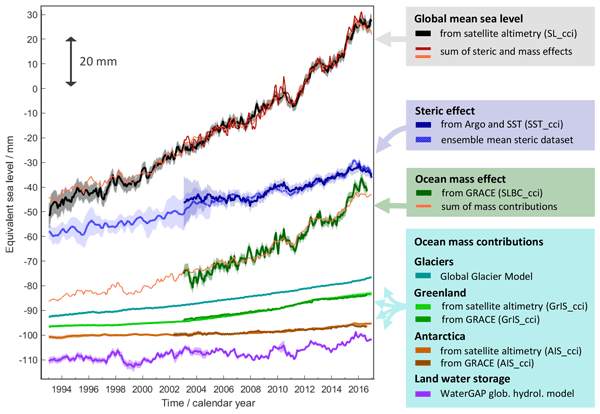
Global mean sea-level change observed from 1993 to 2016 (mean rate of 3.05 mm yr−1) matches the combined effect of changes in water density (thermal expansion) and ocean mass. Ocean-mass change has been assessed through the contributions from glaciers, ice sheets, and land water storage or directly from satellite data since 2003. Our budget assessments of linear trends and monthly anomalies utilise new datasets and uncertainty characterisations developed within ESA's Climate Change Initiative.
Zhongyang Hu, Peter Kuipers Munneke, Stef Lhermitte, Maaike Izeboud, and Michiel van den Broeke
The Cryosphere, 15, 5639–5658, https://doi.org/10.5194/tc-15-5639-2021, https://doi.org/10.5194/tc-15-5639-2021, 2021
Short summary
Short summary
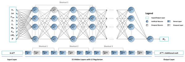
Antarctica is shrinking, and part of the mass loss is caused by higher temperatures leading to more snowmelt. We use computer models to estimate the amount of melt, but this can be inaccurate – specifically in the areas with the most melt. This is because the model cannot account for small, darker areas like rocks or darker ice. Thus, we trained a computer using artificial intelligence and satellite images that showed these darker areas. The model computed an improved estimate of melt.
Kenneth D. Mankoff, Xavier Fettweis, Peter L. Langen, Martin Stendel, Kristian K. Kjeldsen, Nanna B. Karlsson, Brice Noël, Michiel R. van den Broeke, Anne Solgaard, William Colgan, Jason E. Box, Sebastian B. Simonsen, Michalea D. King, Andreas P. Ahlstrøm, Signe Bech Andersen, and Robert S. Fausto
Earth Syst. Sci. Data, 13, 5001–5025, https://doi.org/10.5194/essd-13-5001-2021, https://doi.org/10.5194/essd-13-5001-2021, 2021
Short summary
Short summary
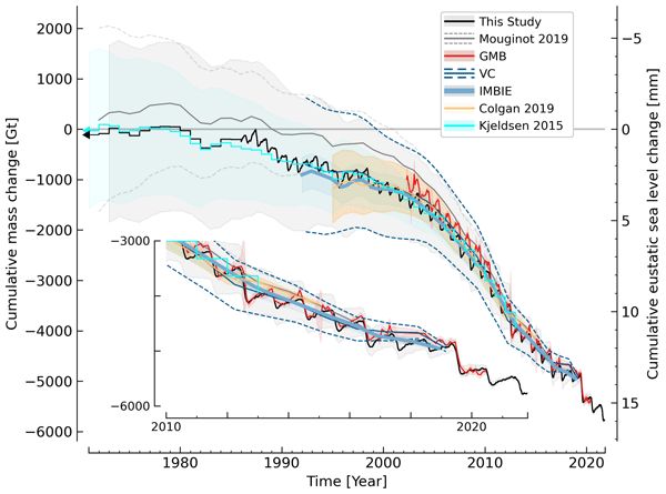
We estimate the daily mass balance and its components (surface, marine, and basal mass balance) for the Greenland ice sheet. Our time series begins in 1840 and has annual resolution through 1985 and then daily from 1986 through next week. Results are operational (updated daily) and provided for the entire ice sheet or by commonly used regions or sectors. This is the first input–output mass balance estimate to include the basal mass balance.

Ben Marzeion
Earth Syst. Dynam., 12, 1057–1060, https://doi.org/10.5194/esd-12-1057-2021, https://doi.org/10.5194/esd-12-1057-2021, 2021
Short summary
Short summary
The oceans are typically darker than land surfaces. Expanding oceans through sea-level rise may thus lead to a darker planet Earth, reflecting less sunlight. The additionally absorbed sunlight may heat planet Earth, leading to further sea-level rise. Here, we provide a rough estimate of the strength of this feedback: it turns out to be very weak, but clearly positive, thereby destabilizing the Earth system.
Cited articles
Bevis, M., Wahr, J., Khan, S. A., Madsen, F. B., Brown, A., Willis, M., Kendrick, E., Knudsen, P., Box, J. E., van Dam, T., and Caccamise, D. J.: Bedrock displacements in Greenland manifest ice mass variations, climate cycles and climate change, Proceedings of the National Academy of Sciences, 109, 11944–11948, 2012.
Church, J. A., Clark, P. U., Cazenave, A., Gregory, J. M., Jevrejeva, S., Levermann, A., Merrifield, M. A., Milne, G. A., Nerem, R. S., Nunn, P. D., Payne, A. J., Pfeffer, W. T., Stammer, D., and Unnikrishnan, A. S.: Sea Level Change. In: Climate Change 2013: The Physical Science Basis. Contribution of Working Group I to the Fifth Assessment Report of the Intergovernmental Panel on Climate Change, edited by: Stocker, T. F., Qin, D., Plattner, G.-K., Tignor, M., Allen, S. K., Boschung, J., Nauels, A., Xia, Y., Bex, V., and Midgley, P. M., Cambridge University Press, Cambridge, United Kingdom and New York, NY, USA, 2013.
Farrell, W. E. and Clark, J. A.: On postglacial sea level, Geophys. J. Int., 46, 647–667, 1976.
Frederikse, T., Riva, R., Slobbe, C., Broerse, T., and Verlaan, M.: Estimating decadal variability in sea level from tide gauge records: An application to the North Sea, J. Geophys. Res.-Oceans, 121, 1529–1545, https://doi.org/10.1002/2015JC011174, 2016.
Hamlington, B. D., Thompson, P., Hammond, W. C., Blewitt, G., and Ray, R. D.: Assessing the impact of vertical land motion on twentieth century global mean sea level estimates, J. Geophys. Res.-Oceans, 121, 4980–4993, 2016.
Khan, S. A., Sasgen, I., Bevis, M., van Dam, T., Bamber, J. L., Wahr, J., Willis, M., Kjær, K. H., Wouters, B., Helm, V., and Csatho, B.: Geodetic measurements reveal similarities between post–Last Glacial Maximum and present-day mass loss from the Greenland ice sheet, Sci. Adv., 2, e1600931, https://doi.org/10.1126/sciadv.1600931, 2016.
King, M. A. and Watson, C. S.: Geodetic vertical velocities affected by recent rapid changes in polar motion, Geophys. J. Int., 199, 1161–1165, 2014.
Kjeldsen, K. K., Korsgaard, N. J., Bjørk, A. A., Khan, S. A., Funder, S., Larsen, N. K., Bamber, J. L., Colgan, W., van den Broeke, M., Siggaard-Andersen, M. L., and Nuth, C.: Spatial and temporal distribution of mass loss from the Greenland Ice Sheet since AD 1900, Nature, 528, 396–400, 2015.
Marzeion, B., Leclercq, P. W., Cogley, J. G., and Jarosch, A. H.: Brief Communication: Global reconstructions of glacier mass change during the 20th century are consistent, The Cryosphere, 9, 2399–2404, https://doi.org/10.5194/tc-9-2399-2015, 2015.
Melini, D., Piersanti, A., Spada, G., Soldati, G., Casarotti, E., and Boschi, E.: Earthquakes and relative sealevel changes, Geophys. Res. Lett., 31, L09601, https://doi.org/10.1029/2003GL019347, 2004.
Nerem, R. S. and Mitchum, G. T.: Estimates of vertical crustal motion derived from differences of TOPEX/POSEIDON and tide gauge sea level measurements, Geophys. Res. Lett., 29, 1934, https://doi.org/10.1029/2002GL015037, 2002.
Peltier, W. R., Argus, D. F., and Drummond, R.: Space geodesy constrains ice age terminal deglaciation: The global ICE-6G_C (VM5a) model, J. Geophys. Res.-Solid Earth, 120, 450–487, 2015.
Pfeffer, W. T., Arendt, A. A., Bliss, A., Bolch, T., Cogley, J. G., Gardner, A. S., Hagen, J. O., Hock, R., Kaser, G., Kienholz, C., and Miles, E. S.: The Randolph Glacier Inventory: a globally complete inventory of glaciers, J. Glaciol., 60, 537–552, 2014.
Riva, R. E. M., Frederikse, T., King, M. A., Marzeion, B., and van den Broeke, M.: Data Supplement to: Brief Communication: The global signature of post-1900 land ice wastage on vertical land motion, available at: https://doi.org/10.4121/uuid:fb667e7a-52f3-4876-8cab-ae7a2ddaf0db, 2017.
Santamaría-Gómez, A., Gravelle, M., and Wöppelmann, G.: Long-term vertical land motion from double-differenced tide gauge and satellite altimetry data, J. Geod., 88, 207–222, https://doi.org/10.1007/s00190-013-0677-5, 2014.
Santamaría-Gómez, A. and Mémin, A.: Geodetic secular velocity errors due to interannual surface loading deformation, Geophys. J. Int., 202, 763–767, 2015.
Shepherd, A., Ivins, E. R., Geruo, A., Barletta, V. R., Bentley, M. J., Bettadpur, S., Briggs, K. H., Bromwich, D. H., Forsberg, R., Galin, N., and Horwath, M.: A reconciled estimate of ice-sheet mass balance, Science, 338, 1183–1189, 2012.
Tamisiea, M. E., Hill, E. M., Ponte, R. M., Davis, J. L., Velicogna, I., and Vinogradova, N. T.: Impact of self-attraction and loading on the annual cycle in sea level, J. Geophys. Res., 115, C07004, https://doi.org/10.1029/2009JC005687, 2010.
Thompson, P. R., Hamlington, B. D., Landerer, F. W., and Adhikari, S.: Are long tide gauge records in the wrong place to measure global mean sea level rise?, Geophys. Res. Lett., 43, 10403–10411, https://doi.org/10.1002/2016GL070552, 2016.
van den Broeke, M. R., Enderlin, E. M., Howat, I. M., Kuipers Munneke, P., Noël, B. P. Y., van de Berg, W. J., van Meijgaard, E., and Wouters, B.: On the recent contribution of the Greenland ice sheet to sea level change, The Cryosphere, 10, 1933–1946, https://doi.org/10.5194/tc-10-1933-2016, 2016.
Watkins, M. M., Wiese, D. N., Yuan, D.-N., Boening, C., and Landerer, F. W.: Improved methods for observing Earth's time variable mass distribution with GRACE using spherical cap mascons, J. Geophys. Res.-Solid Earth, 120, 2648–2671, https://doi.org/10.1002/2014JB011547, 2015.
Watson, C. S., White, N. J., Church, J. A., King, M. A., Burgette, R. J., and Legresy, B.: Unabated global mean sea-level rise over the satellite altimeter era, Nature Climate Change, 5, 565–568, 2015.
Wöppelmann, G. and Marcos, M.: Vertical land motion as a key to understanding sea level change and variability, Rev. Geophys., 54, 64–92, https://doi.org/10.1002/2015RG000502, 2016.
Wöppelmann, G., Marcos, M., Santamaría-Gómez, A., Martín-Míguez, B., Bouin, M.-N., and Gravelle, M.: Evidence for a differential sea level rise between hemispheres over the twentieth century, Geophys. Res. Lett., 41, 1639–1643, https://doi.org/10.1002/2013GL059039, 2014.
Short summary
The reduction of ice masses stored on land has made an important contribution to sea-level rise over the last century, as well as changed the Earth's shape. We model the solid-earth response to ice mass changes and find significant vertical deformation signals over large continental areas. We show how deformation rates have varied strongly throughout the last century, which affects the interpretation and extrapolation of recent observations of vertical land motion and sea-level change.
The reduction of ice masses stored on land has made an important contribution to sea-level rise...


