
Articles | Volume 8, issue 6
https://doi.org/10.5194/tc-8-2381-2014
© Author(s) 2014. This work is distributed under
the Creative Commons Attribution 3.0 License.
the Creative Commons Attribution 3.0 License.
https://doi.org/10.5194/tc-8-2381-2014
© Author(s) 2014. This work is distributed under
the Creative Commons Attribution 3.0 License.
the Creative Commons Attribution 3.0 License.
Research article
| 
20 Dec 2014
Research article |
| 20 Dec 2014
Elevation dependency of mountain snow depth
T. Grünewald
WSL Institute for Snow and Avalanche Research SLF, 7260 Davos, Switzerland
Cryos, School of Architecture, Civil and Environmental Engineering, École Polytechnique Fédérale de Lausanne, 1015 Lausanne, Switzerland
Y. Bühler
WSL Institute for Snow and Avalanche Research SLF, 7260 Davos, Switzerland
M. Lehning
WSL Institute for Snow and Avalanche Research SLF, 7260 Davos, Switzerland
Cryos, School of Architecture, Civil and Environmental Engineering, École Polytechnique Fédérale de Lausanne, 1015 Lausanne, Switzerland
Related authors
No articles found.
Feiko Bernard van Zadelhoff, Yves Bühler, and Michael Bründl
EGUsphere, https://doi.org/10.5194/egusphere-2026-4604, https://doi.org/10.5194/egusphere-2026-4604, 2026
This preprint is open for discussion and under review for Natural Hazards and Earth System Sciences (NHESS).
Short summary
Short summary
Debris flows are a major hazard in mountainous areas, causing millions of francs in damage in Switzerland every year. Therefore, the Swiss national railway company aims to identify dangerous areas along their infrastructure. We perform this analysis by identifying critical areas using machine learning and detailed simulation modelling of debris flow events caused by extreme rainfall. The results are a valuable baseline to plan mitigation measures and be better prepared for the future.
Jan Kleinn, Dörte Aller, Yves Bühler, Julia Glaus, Adrian Peter, and Nils Hählen
EGUsphere, https://doi.org/10.5194/egusphere-2026-3799, https://doi.org/10.5194/egusphere-2026-3799, 2026
This preprint is open for discussion and under review for Natural Hazards and Earth System Sciences (NHESS).
Short summary
Short summary
We have demonstrated that it is possible to apply an approach to hazard and risk modelling of avalanches, which is commonly used for seismic risks and other hazards. This approach provides more differentiated results and additional information compared to the current approach used in Switzerland for hazard assessment. The applicability of the approach has been demonstrated with an avalanche model commonly used in Switzerland and can be applied to other avalanche models.
Isabella Anglin, Adriaan J. Teuling, Marius G. Floriancic, Michael Lehning, and Harsh Beria
EGUsphere, https://doi.org/10.5194/egusphere-2026-4268, https://doi.org/10.5194/egusphere-2026-4268, 2026
This preprint is open for discussion and under review for The Cryosphere (TC).
Short summary
Short summary
Snow sublimation is the direct vapor loss of snow to the atmosphere, reducing spring snowmelt that recharges soils, groundwater, and rivers. Using eddy-covariance measurements over a full winter in the eastern Swiss Alps, we found that sublimation removed about 25 mm of water, or nearly 6 % of the season’s peak snow water storage. Sublimation losses were highest late in the season, showing that this hidden process can meaningfully reduce mountain water supplies.
Pia Ruttner, Nora Helbig, Annelies Voordendag, Andreas Wieser, and Yves Bühler
The Cryosphere, 20, 4185–4208, https://doi.org/10.5194/tc-20-4185-2026, https://doi.org/10.5194/tc-20-4185-2026, 2026
Short summary
Short summary
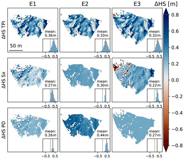
The spatial variability of snow depth distribution in avalanche release areas is key for avalanche forecasting but is strongly influenced by the interaction of wind with the terrain. We generate maps of high resolution snow depth changes during three snowfall events by using low-cost terrestrial laser scanner measurements and compare them to the results of selected snow depth distribution models. We show that basic terrain derivations have the highest correlations to our measurement results.
Francesca Carletti, Nora Helbig, Nander Wever, Loïc Brouet, Mathias Bavay, Benjamin Walter, and Michael Lehning
EGUsphere, https://doi.org/10.5194/egusphere-2026-3049, https://doi.org/10.5194/egusphere-2026-3049, 2026
Short summary
Short summary
Melting alpine snowfields develop cup-shaped hollows that reduce how much sunlight the snow reflects, accelerating melt. Over three seasons in the Swiss Alps, we monitored how these hollows form and grow with a laser scanner. Two processes reduce reflectivity simultaneously: hollows trap light through internal reflections, and meltwater washes dark particles into them. Because they are difficult to separate, surface roughness alone emerges as a reliable proxy for overall reflectivity loss.
Mahdi Jafari and Michael Lehning
The Cryosphere, 20, 2439–2467, https://doi.org/10.5194/tc-20-2439-2026, https://doi.org/10.5194/tc-20-2439-2026, 2026
Short summary
Short summary
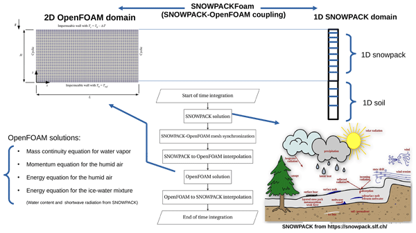
We studied how air moves within snow in Arctic regions and how this affects the snow's structure. Using a new method that links two computer models, we found that cold weather can trigger air movement inside the snow, creating vertical channels and changing the snow's density and temperature. These changes are not captured by traditional models, so our work helps improve how snow and climate processes are simulated in cold environments.
Samuele Viaro, Armin Sigmund, Evan Thomas, and Michael Lehning
EGUsphere, https://doi.org/10.5194/egusphere-2026-2132, https://doi.org/10.5194/egusphere-2026-2132, 2026
Preprint archived
Short summary
Short summary
Our research focuses in understanding snow processes at the surface-atmosphere interface, and their influence at larger scales. The use of our advanced numerical model, which includes blowing snow equations, proved to be valuable in predicting the observed ice crystal concentration number at an alpine site. We further demonstrate the effect of blowing snow particles in precipitation and erosion-deposition patterns. Finally, secondary ice production mechanisms are also treated.
Elizabeth Fischer, Gabriel J. Wolken, Yves Bühler, Marc Christen, and Rick Lader
EGUsphere, https://doi.org/10.5194/egusphere-2026-1345, https://doi.org/10.5194/egusphere-2026-1345, 2026
This preprint is open for discussion and under review for Natural Hazards and Earth System Sciences (NHESS).
Short summary
Short summary
Snow avalanches are a major hazard in Southeast Alaska, where limited data and climate change complicate risk planning. We created the first regional hazard maps using past and projected climate conditions. Results show hazard decreasing at lower elevations as rain replaces snow but increasing at high elevations due to more snow and longer avalanche runouts. These maps provide an important tool for informed land-use and infrastructure planning as Alaska’s landscapes adapt to a changing climate.
Julia Glaus, Jan Kleinn, Lukas Stoffel, Pia Ruttner, Katreen Wikstrom Jones, Johan Gaume, and Yves Bühler
EGUsphere, https://doi.org/10.5194/egusphere-2026-999, https://doi.org/10.5194/egusphere-2026-999, 2026
Short summary
Short summary
Snow avalanches threaten roads, ski areas, and communities in mountain regions. We present a practical method to create daily maps showing where avalanches are likely to travel and how strong they may be. By combining weather data, snow measurements, and computer simulations, our approach supports safer decisions on road closures and avalanche control and helps protect people and infrastructure.

Jaeyoung Lim, Elisabeth Hafner-Aeschbacher, Florian Achermann, Rik Girod, David Rohr, Nicholas Lawrance, Yves Bühler, and Roland Siegwart
Nat. Hazards Earth Syst. Sci., 26, 411–431, https://doi.org/10.5194/nhess-26-411-2026, https://doi.org/10.5194/nhess-26-411-2026, 2026
Short summary
Short summary
As avalanches occur in remote and potentially dangerous locations, data relevant to avalanche monitoring is difficult to obtain. Uncrewed fixed-wing aerial vehicles are promising platforms for gathering aerial imagery to map avalanche activity over a large area. In this work, we present an unmanned aerial system (UAS) capable of autonomously navigating and mapping avalanches in steep mountainous terrain. We expect our work to enable efficient large-scale autonomous avalanche monitoring.
Brandon Jacobus Adrianus van Schaik, Alice Juliette Baruzier, Clément Loyer, Hendrik Huwald, and Michael Lehning
Wind Energ. Sci. Discuss., https://doi.org/10.5194/wes-2025-271, https://doi.org/10.5194/wes-2025-271, 2025
Preprint under review for WES
Short summary
Short summary
We created a new way to estimate how much energy a wind turbine can produce by using the full change of wind with height instead of a single measurement. Testing it on turbines in the Swiss Alps showed that it predicts energy production more accurately and smoothly than current industry methods. It performs as well as advanced models but is much faster, helping guide future wind projects in complex landscapes.
Francesca Carletti, Carlo Marin, Chiara Ghielmini, Mathias Bavay, and Michael Lehning
The Cryosphere, 19, 5579–5612, https://doi.org/10.5194/tc-19-5579-2025, https://doi.org/10.5194/tc-19-5579-2025, 2025
Short summary
Short summary
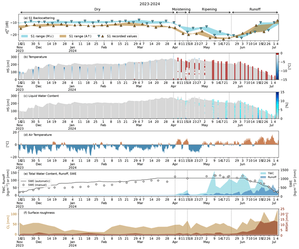
This work presents the first high-resolution dataset of wet-snow properties for satellite applications. With it, we validate links between Sentinel-1 backscatter and snowmelt stages and investigate scattering mechanisms through a radiative transfer model. We disclose the influence of liquid water content and surface roughness at different melting stages and address future challenges, such as capturing large-scale scattering mechanisms and enhancing radiative transfer modules for wet snow.
Hongxiang Yu, Li Guang, Benjamin Walter, Jianping Huang, Ning Huang, and Michael Lehning
The Cryosphere, 19, 5389–5402, https://doi.org/10.5194/tc-19-5389-2025, https://doi.org/10.5194/tc-19-5389-2025, 2025
Short summary
Short summary
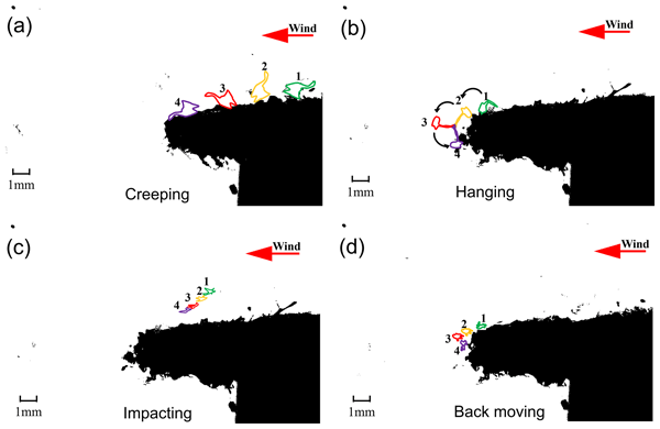
Cornices are overhanging snow accumulations that form on mountain crests. Using wind-tunnel experiments and high-speed photography, the study tracks particle trajectories around cornices and finds distinct differences between edge and surface deposition. A static adhesion model for edge deposition was developed and validated to predict how particle size and shape affect adhesion. The work clarifies the microdynamics of early cornice growth and provides a foundation for avalanche modeling.
Tiziana Lazzarina Zendrini, Luca Carturan, Michael Lehning, Mathias Bavay, Federico Cazorzi, Paolo Gabrielli, Nander Wever, and Giancarlo Dalla Fontana
EGUsphere, https://doi.org/10.5194/egusphere-2025-5186, https://doi.org/10.5194/egusphere-2025-5186, 2025
Short summary
Short summary
By combining in situ mass balance data with a physics‐based snow model at Mt. Ortles, in the Italian Alps, we investigate snow accumulation, erosion and melt processes, and their sensitivity to air temperature. We found that wind erosion is currently the major ablation process at this high-elevation site, whereas melt plays a minor role. Quickly rising air temperature is affecting this partitioning and suggests a future shift from an erosion-dominated to a melt-dominated mass balance regime.
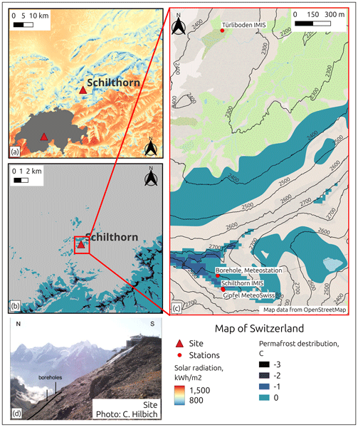
Elizaveta Sharaborova, Michael Lehning, Nander Wever, Marcia Phillips, and Hendrik Huwald
The Cryosphere, 19, 4277–4301, https://doi.org/10.5194/tc-19-4277-2025, https://doi.org/10.5194/tc-19-4277-2025, 2025
Short summary
Short summary
Global warming provokes permafrost to thaw, damaging landscapes and infrastructure. This study explores methods to slow this thawing at an alpine site. We investigate different methods based on passive and active cooling. The best approach mixes both methods and manages heat flow, potentially allowing excess energy to be used locally.

Julia Glaus, Katreen Wikstrom Jones, Perry Bartelt, Marc Christen, Lukas Stoffel, Johan Gaume, and Yves Bühler
Nat. Hazards Earth Syst. Sci., 25, 2399–2419, https://doi.org/10.5194/nhess-25-2399-2025, https://doi.org/10.5194/nhess-25-2399-2025, 2025
Short summary
Short summary
This study assesses RAMMS::EXTENDED's predictive power in estimating avalanche runout distances critical for mountain road safety. Leveraging meteorological data and sensitivity analyses, it offers meaningful predictions, aiding near real-time hazard assessments and future model refinement for improved decision-making.
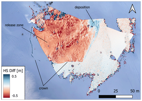
Pia Ruttner, Annelies Voordendag, Thierry Hartmann, Julia Glaus, Andreas Wieser, and Yves Bühler
Nat. Hazards Earth Syst. Sci., 25, 1315–1330, https://doi.org/10.5194/nhess-25-1315-2025, https://doi.org/10.5194/nhess-25-1315-2025, 2025
Short summary
Short summary
Snow depth variations caused by wind are an important factor in avalanche danger, but detailed and up-to-date information is rarely available. We propose a monitoring system, using lidar and optical sensors, to measure the snow depth distribution at high spatial and temporal resolution. First results show that we can quantify snow depth changes with an accuracy on the low decimeter level, or better, and can identify events such as avalanches or displacement of snow during periods of strong winds.
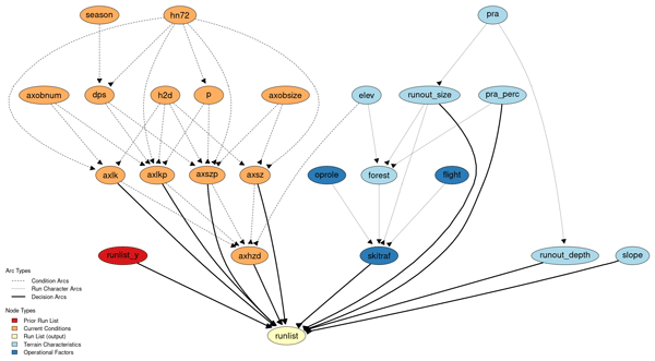
John Sykes, Pascal Haegeli, Roger Atkins, Patrick Mair, and Yves Bühler
Nat. Hazards Earth Syst. Sci., 25, 1255–1292, https://doi.org/10.5194/nhess-25-1255-2025, https://doi.org/10.5194/nhess-25-1255-2025, 2025
Short summary
Short summary
We model the decision-making of professional ski guides and develop decision support tools to assist with determining appropriate terrain based on current conditions. Our approach compares a manually constructed Bayesian network with machine learning classification models. The models accurately capture the real-world decision-making outcomes in 85–93 % of cases. Our conclusions focus on strengths and weaknesses of each model and discuss ramifications for practical applications in ski guiding.
Jan Magnusson, Yves Bühler, Louis Quéno, Bertrand Cluzet, Giulia Mazzotti, Clare Webster, Rebecca Mott, and Tobias Jonas
Earth Syst. Sci. Data, 17, 703–717, https://doi.org/10.5194/essd-17-703-2025, https://doi.org/10.5194/essd-17-703-2025, 2025
Short summary
Short summary
In this study, we present a dataset for the Dischma catchment in eastern Switzerland, which represents a typical high-alpine watershed in the European Alps. Accurate monitoring and reliable forecasting of snow and water resources in such basins are crucial for a wide range of applications. Our dataset is valuable for improving physics-based snow, land surface, and hydrological models, with potential applications in similar high-alpine catchments.
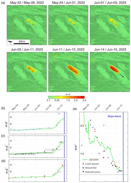
Andrea Manconi, Yves Bühler, Andreas Stoffel, Johan Gaume, Qiaoping Zhang, and Valentyn Tolpekin
Nat. Hazards Earth Syst. Sci., 24, 3833–3839, https://doi.org/10.5194/nhess-24-3833-2024, https://doi.org/10.5194/nhess-24-3833-2024, 2024
Short summary
Short summary
Our research reveals the power of high-resolution satellite synthetic-aperture radar (SAR) imagery for slope deformation monitoring. Using ICEYE data over the Brienz/Brinzauls instability, we measured surface velocity and mapped the landslide event with unprecedented precision. This underscores the potential of satellite SAR for timely hazard assessment in remote regions and aiding disaster mitigation efforts effectively.
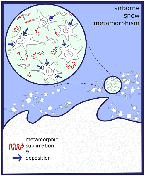
Sonja Wahl, Benjamin Walter, Franziska Aemisegger, Luca Bianchi, and Michael Lehning
The Cryosphere, 18, 4493–4515, https://doi.org/10.5194/tc-18-4493-2024, https://doi.org/10.5194/tc-18-4493-2024, 2024
Short summary
Short summary
Wind-driven airborne transport of snow is a frequent phenomenon in snow-covered regions and a process difficult to study in the field as it is unfolding over large distances. Thus, we use a ring wind tunnel with infinite fetch positioned in a cold laboratory to study the evolution of the shape and size of airborne snow. With the help of stable water isotope analyses, we identify the hitherto unobserved process of airborne snow metamorphism that leads to snow particle rounding and growth.
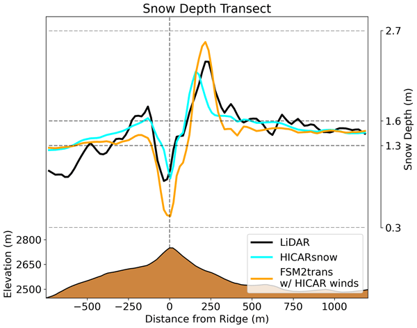
Dylan Reynolds, Louis Quéno, Michael Lehning, Mahdi Jafari, Justine Berg, Tobias Jonas, Michael Haugeneder, and Rebecca Mott
The Cryosphere, 18, 4315–4333, https://doi.org/10.5194/tc-18-4315-2024, https://doi.org/10.5194/tc-18-4315-2024, 2024
Short summary
Short summary
Information about atmospheric variables is needed to produce simulations of mountain snowpacks. We present a model that can represent processes that shape mountain snowpack, focusing on the accumulation of snow. Simulations show that this model can simulate the complex path that a snowflake takes towards the ground and that this leads to differences in the distribution of snow by the end of winter. Overall, this model shows promise with regard to improving forecasts of snow in mountains.
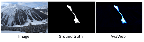
Elisabeth D. Hafner, Theodora Kontogianni, Rodrigo Caye Daudt, Lucien Oberson, Jan Dirk Wegner, Konrad Schindler, and Yves Bühler
The Cryosphere, 18, 3807–3823, https://doi.org/10.5194/tc-18-3807-2024, https://doi.org/10.5194/tc-18-3807-2024, 2024
Short summary
Short summary
For many safety-related applications such as road management, well-documented avalanches are important. To enlarge the information, webcams may be used. We propose supporting the mapping of avalanches from webcams with a machine learning model that interactively works together with the human. Relying on that model, there is a 90% saving of time compared to the "traditional" mapping. This gives a better base for safety-critical decisions and planning in avalanche-prone mountain regions.
Benjamin Bouchard, Daniel F. Nadeau, Florent Domine, Nander Wever, Adrien Michel, Michael Lehning, and Pierre-Erik Isabelle
The Cryosphere, 18, 2783–2807, https://doi.org/10.5194/tc-18-2783-2024, https://doi.org/10.5194/tc-18-2783-2024, 2024
Short summary
Short summary
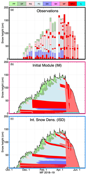
Observations over several winters at two boreal sites in eastern Canada show that rain-on-snow (ROS) events lead to the formation of melt–freeze layers and that preferential flow is an important water transport mechanism in the sub-canopy snowpack. Simulations with SNOWPACK generally show good agreement with observations, except for the reproduction of melt–freeze layers. This was improved by simulating intercepted snow microstructure evolution, which also modulates ROS-induced runoff.
Daniela Brito Melo, Armin Sigmund, and Michael Lehning
The Cryosphere, 18, 1287–1313, https://doi.org/10.5194/tc-18-1287-2024, https://doi.org/10.5194/tc-18-1287-2024, 2024
Short summary
Short summary
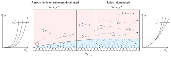
Snow saltation – the transport of snow close to the surface – occurs when the wind blows over a snow-covered surface with sufficient strength. This phenomenon is represented in some climate models; however, with limited accuracy. By performing numerical simulations and a detailed analysis of previous works, we show that snow saltation is characterized by two regimes. This is not represented in climate models in a consistent way, which hinders the quantification of snow transport and sublimation.
Dylan Reynolds, Ethan Gutmann, Bert Kruyt, Michael Haugeneder, Tobias Jonas, Franziska Gerber, Michael Lehning, and Rebecca Mott
Geosci. Model Dev., 16, 5049–5068, https://doi.org/10.5194/gmd-16-5049-2023, https://doi.org/10.5194/gmd-16-5049-2023, 2023
Short summary
Short summary
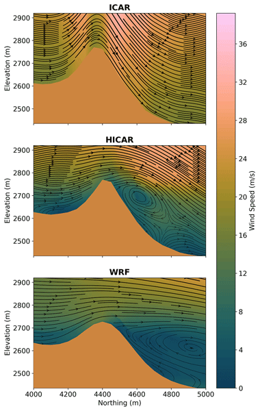
The challenge of running geophysical models is often compounded by the question of where to obtain appropriate data to give as input to a model. Here we present the HICAR model, a simplified atmospheric model capable of running at spatial resolutions of hectometers for long time series or over large domains. This makes physically consistent atmospheric data available at the spatial and temporal scales needed for some terrestrial modeling applications, for example seasonal snow forecasting.
Elisabeth D. Hafner, Frank Techel, Rodrigo Caye Daudt, Jan Dirk Wegner, Konrad Schindler, and Yves Bühler
Nat. Hazards Earth Syst. Sci., 23, 2895–2914, https://doi.org/10.5194/nhess-23-2895-2023, https://doi.org/10.5194/nhess-23-2895-2023, 2023
Short summary
Short summary
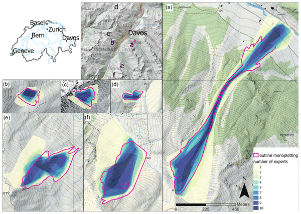
Oftentimes when objective measurements are not possible, human estimates are used instead. In our study, we investigate the reproducibility of human judgement for size estimates, the mappings of avalanches from oblique photographs and remotely sensed imagery. The variability that we found in those estimates is worth considering as it may influence results and should be kept in mind for several applications.
Leon J. Bührle, Mauro Marty, Lucie A. Eberhard, Andreas Stoffel, Elisabeth D. Hafner, and Yves Bühler
The Cryosphere, 17, 3383–3408, https://doi.org/10.5194/tc-17-3383-2023, https://doi.org/10.5194/tc-17-3383-2023, 2023
Short summary
Short summary
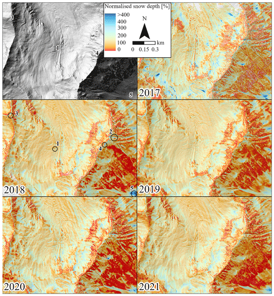
Information on the snow depth distribution is crucial for numerous applications in high-mountain regions. However, only specific measurements can accurately map the present variability of snow depths within complex terrain. In this study, we show the reliable processing of images from aeroplane to large (> 100 km2) detailed and accurate snow depth maps around Davos (CH). We use these maps to describe the existing snow depth distribution, other special features and potential applications.
Adrian Ringenbach, Peter Bebi, Perry Bartelt, Andreas Rigling, Marc Christen, Yves Bühler, Andreas Stoffel, and Andrin Caviezel
Earth Surf. Dynam., 11, 779–801, https://doi.org/10.5194/esurf-11-779-2023, https://doi.org/10.5194/esurf-11-779-2023, 2023
Short summary
Short summary
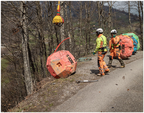
Swiss researchers carried out repeated rockfall experiments with rocks up to human sizes in a steep mountain forest. This study focuses mainly on the effects of the rock shape and lying deadwood. In forested areas, cubic-shaped rocks showed a longer mean runout distance than platy-shaped rocks. Deadwood especially reduced the runouts of these cubic rocks. The findings enrich standard practices in modern rockfall hazard zoning assessments and strongly urge the incorporation of rock shape effects.
Gregor Ortner, Michael Bründl, Chahan M. Kropf, Thomas Röösli, Yves Bühler, and David N. Bresch
Nat. Hazards Earth Syst. Sci., 23, 2089–2110, https://doi.org/10.5194/nhess-23-2089-2023, https://doi.org/10.5194/nhess-23-2089-2023, 2023
Short summary
Short summary
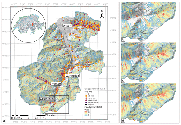
This paper presents a new approach to assess avalanche risk on a large scale in mountainous regions. It combines a large-scale avalanche modeling method with a state-of-the-art probabilistic risk tool. Over 40 000 individual avalanches were simulated, and a building dataset with over 13 000 single buildings was investigated. With this new method, risk hotspots can be identified and surveyed. This enables current and future risk analysis to assist decision makers in risk reduction and adaptation.

Hongxiang Yu, Guang Li, Benjamin Walter, Michael Lehning, Jie Zhang, and Ning Huang
The Cryosphere, 17, 639–651, https://doi.org/10.5194/tc-17-639-2023, https://doi.org/10.5194/tc-17-639-2023, 2023
Short summary
Short summary
Snow cornices lead to the potential risk of causing snow avalanche hazards, which are still unknown so far. We carried out a wind tunnel experiment in a cold lab to investigate the environmental conditions for snow cornice accretion recorded by a camera. The length growth rate of the cornices reaches a maximum for wind speeds approximately 40 % higher than the threshold wind speed. Experimental results improve our understanding of the cornice formation process.
Varun Sharma, Franziska Gerber, and Michael Lehning
Geosci. Model Dev., 16, 719–749, https://doi.org/10.5194/gmd-16-719-2023, https://doi.org/10.5194/gmd-16-719-2023, 2023
Short summary
Short summary
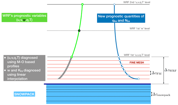
Most current generation climate and weather models have a relatively simplistic description of snow and snow–atmosphere interaction. One reason for this is the belief that including an advanced snow model would make the simulations too computationally demanding. In this study, we bring together two state-of-the-art models for atmosphere (WRF) and snow cover (SNOWPACK) and highlight both the feasibility and necessity of such coupled models to explore underexplored phenomena in the cryosphere.

Adrian Ringenbach, Peter Bebi, Perry Bartelt, Andreas Rigling, Marc Christen, Yves Bühler, Andreas Stoffel, and Andrin Caviezel
Earth Surf. Dynam., 10, 1303–1319, https://doi.org/10.5194/esurf-10-1303-2022, https://doi.org/10.5194/esurf-10-1303-2022, 2022
Short summary
Short summary
The presented automatic deadwood generator (ADG) allows us to consider deadwood in rockfall simulations in unprecedented detail. Besides three-dimensional fresh deadwood cones, we include old woody debris in rockfall simulations based on a higher compaction rate and lower energy absorption thresholds. Simulations including different deadwood states indicate that a 10-year-old deadwood pile has a higher protective capacity than a pre-storm forest stand.
John Sykes, Pascal Haegeli, and Yves Bühler
Nat. Hazards Earth Syst. Sci., 22, 3247–3270, https://doi.org/10.5194/nhess-22-3247-2022, https://doi.org/10.5194/nhess-22-3247-2022, 2022
Short summary
Short summary
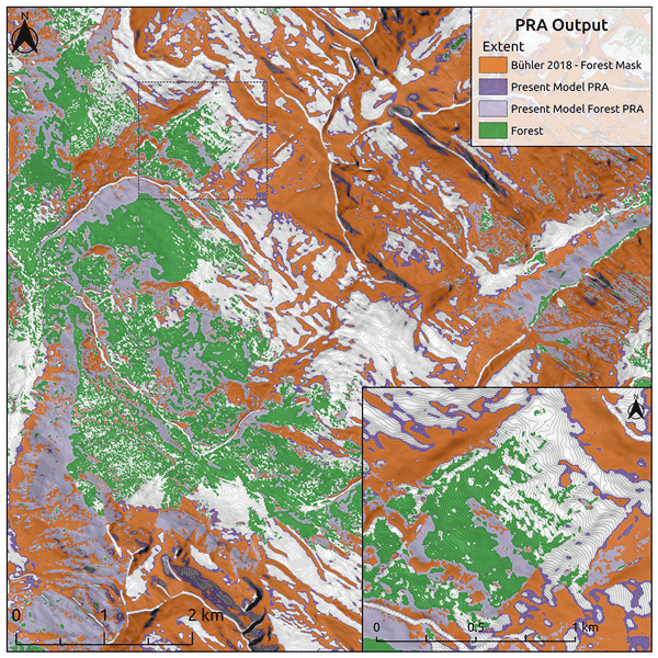
Automated snow avalanche terrain mapping provides an efficient method for large-scale assessment of avalanche hazards, which informs risk management decisions for transportation and recreation. This research reduces the cost of developing avalanche terrain maps by using satellite imagery and open-source software as well as improving performance in forested terrain. The research relies on local expertise to evaluate accuracy, so the methods are broadly applicable in mountainous regions worldwide.
Elisabeth D. Hafner, Patrick Barton, Rodrigo Caye Daudt, Jan Dirk Wegner, Konrad Schindler, and Yves Bühler
The Cryosphere, 16, 3517–3530, https://doi.org/10.5194/tc-16-3517-2022, https://doi.org/10.5194/tc-16-3517-2022, 2022
Short summary
Short summary
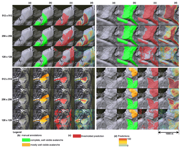
Knowing where avalanches occur is very important information for several disciplines, for example avalanche warning, hazard zonation and risk management. Satellite imagery can provide such data systematically over large regions. In our work we propose a machine learning model to automate the time-consuming manual mapping. Additionally, we investigate expert agreement for manual avalanche mapping, showing that our network is equally as good as the experts in identifying avalanches.
Océane Hames, Mahdi Jafari, David Nicholas Wagner, Ian Raphael, David Clemens-Sewall, Chris Polashenski, Matthew D. Shupe, Martin Schneebeli, and Michael Lehning
Geosci. Model Dev., 15, 6429–6449, https://doi.org/10.5194/gmd-15-6429-2022, https://doi.org/10.5194/gmd-15-6429-2022, 2022
Short summary
Short summary
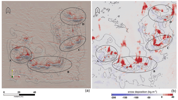
This paper presents an Eulerian–Lagrangian snow transport model implemented in the fluid dynamics software OpenFOAM, which we call snowBedFoam 1.0. We apply this model to reproduce snow deposition on a piece of ridged Arctic sea ice, which was produced during the MOSAiC expedition through scan measurements. The model appears to successfully reproduce the enhanced snow accumulation and deposition patterns, although some quantitative uncertainties were shown.
Aubrey Miller, Pascal Sirguey, Simon Morris, Perry Bartelt, Nicolas Cullen, Todd Redpath, Kevin Thompson, and Yves Bühler
Nat. Hazards Earth Syst. Sci., 22, 2673–2701, https://doi.org/10.5194/nhess-22-2673-2022, https://doi.org/10.5194/nhess-22-2673-2022, 2022
Short summary
Short summary
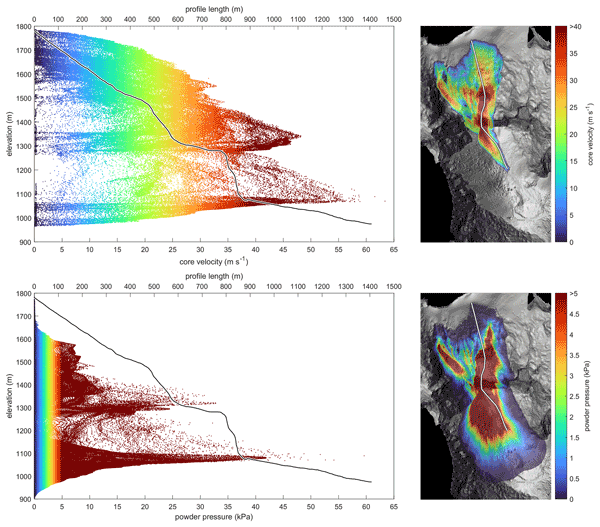
Natural hazard modelers simulate mass movements to better anticipate the risk to people and infrastructure. These simulations require accurate digital elevation models. We test the sensitivity of a well-established snow avalanche model (RAMMS) to the source and spatial resolution of the elevation model. We find key differences in the digital representation of terrain greatly affect the simulated avalanche results, with implications for hazard planning.
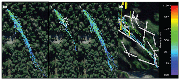
Adrian Ringenbach, Elia Stihl, Yves Bühler, Peter Bebi, Perry Bartelt, Andreas Rigling, Marc Christen, Guang Lu, Andreas Stoffel, Martin Kistler, Sandro Degonda, Kevin Simmler, Daniel Mader, and Andrin Caviezel
Nat. Hazards Earth Syst. Sci., 22, 2433–2443, https://doi.org/10.5194/nhess-22-2433-2022, https://doi.org/10.5194/nhess-22-2433-2022, 2022
Short summary
Short summary
Forests have a recognized braking effect on rockfalls. The impact of lying deadwood, however, is mainly neglected. We conducted 1 : 1-scale rockfall experiments in three different states of a spruce forest to fill this knowledge gap: the original forest, the forest including lying deadwood and the cleared area. The deposition points clearly show that deadwood has a protective effect. We reproduced those experimental results numerically, considering three-dimensional cones to be deadwood.

Francesca Carletti, Adrien Michel, Francesca Casale, Alice Burri, Daniele Bocchiola, Mathias Bavay, and Michael Lehning
Hydrol. Earth Syst. Sci., 26, 3447–3475, https://doi.org/10.5194/hess-26-3447-2022, https://doi.org/10.5194/hess-26-3447-2022, 2022
Short summary
Short summary
High Alpine catchments are dominated by the melting of seasonal snow cover and glaciers, whose amount and seasonality are expected to be modified by climate change. This paper compares the performances of different types of models in reproducing discharge among two catchments under present conditions and climate change. Despite many advantages, the use of simpler models for climate change applications is controversial as they do not fully represent the physics of the involved processes.
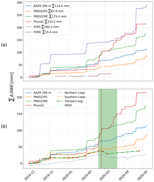
David N. Wagner, Matthew D. Shupe, Christopher Cox, Ola G. Persson, Taneil Uttal, Markus M. Frey, Amélie Kirchgaessner, Martin Schneebeli, Matthias Jaggi, Amy R. Macfarlane, Polona Itkin, Stefanie Arndt, Stefan Hendricks, Daniela Krampe, Marcel Nicolaus, Robert Ricker, Julia Regnery, Nikolai Kolabutin, Egor Shimanshuck, Marc Oggier, Ian Raphael, Julienne Stroeve, and Michael Lehning
The Cryosphere, 16, 2373–2402, https://doi.org/10.5194/tc-16-2373-2022, https://doi.org/10.5194/tc-16-2373-2022, 2022
Short summary
Short summary
Based on measurements of the snow cover over sea ice and atmospheric measurements, we estimate snowfall and snow accumulation for the MOSAiC ice floe, between November 2019 and May 2020. For this period, we estimate 98–114 mm of precipitation. We suggest that about 34 mm of snow water equivalent accumulated until the end of April 2020 and that at least about 50 % of the precipitated snow was eroded or sublimated. Further, we suggest explanations for potential snowfall overestimation.
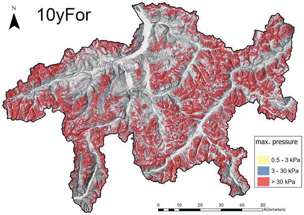
Yves Bühler, Peter Bebi, Marc Christen, Stefan Margreth, Lukas Stoffel, Andreas Stoffel, Christoph Marty, Gregor Schmucki, Andrin Caviezel, Roderick Kühne, Stephan Wohlwend, and Perry Bartelt
Nat. Hazards Earth Syst. Sci., 22, 1825–1843, https://doi.org/10.5194/nhess-22-1825-2022, https://doi.org/10.5194/nhess-22-1825-2022, 2022
Short summary
Short summary
To calculate and visualize the potential avalanche hazard, we develop a method that automatically and efficiently pinpoints avalanche starting zones and simulate their runout for the entire canton of Grisons. The maps produced in this way highlight areas that could be endangered by avalanches and are extremely useful in multiple applications for the cantonal authorities, including the planning of new infrastructure, making alpine regions more safe.
Animesh K. Gain, Yves Bühler, Pascal Haegeli, Daniela Molinari, Mario Parise, David J. Peres, Joaquim G. Pinto, Kai Schröter, Ricardo M. Trigo, María Carmen Llasat, and Heidi Kreibich
Nat. Hazards Earth Syst. Sci., 22, 985–993, https://doi.org/10.5194/nhess-22-985-2022, https://doi.org/10.5194/nhess-22-985-2022, 2022
Short summary
Short summary
To mark the 20th anniversary of Natural Hazards and Earth System Sciences (NHESS), an interdisciplinary and international journal dedicated to the public discussion and open-access publication of high-quality studies and original research on natural hazards and their consequences, we highlight 11 key publications covering major subject areas of NHESS that stood out within the past 20 years.
Joel Fiddes, Kristoffer Aalstad, and Michael Lehning
Geosci. Model Dev., 15, 1753–1768, https://doi.org/10.5194/gmd-15-1753-2022, https://doi.org/10.5194/gmd-15-1753-2022, 2022
Short summary
Short summary
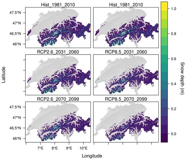
This study describes and evaluates a new downscaling scheme that addresses the need for hillslope-scale atmospheric forcing time series for modelling the local impact of regional climate change on the land surface in mountain areas. The method has a global scope and is able to generate all model forcing variables required for hydrological and land surface modelling. This is important, as impact models require high-resolution forcings such as those generated here to produce meaningful results.
Adrien Michel, Bettina Schaefli, Nander Wever, Harry Zekollari, Michael Lehning, and Hendrik Huwald
Hydrol. Earth Syst. Sci., 26, 1063–1087, https://doi.org/10.5194/hess-26-1063-2022, https://doi.org/10.5194/hess-26-1063-2022, 2022
Short summary
Short summary
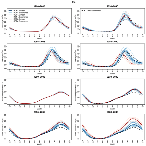
This study presents an extensive study of climate change impacts on river temperature in Switzerland. Results show that, even for low-emission scenarios, water temperature increase will lead to adverse effects for both ecosystems and socio-economic sectors throughout the 21st century. For high-emission scenarios, the effect will worsen. This study also shows that water seasonal warming will be different between the Alpine regions and the lowlands. Finally, efficiency of models is assessed.
Natalie Brožová, Tommaso Baggio, Vincenzo D'Agostino, Yves Bühler, and Peter Bebi
Nat. Hazards Earth Syst. Sci., 21, 3539–3562, https://doi.org/10.5194/nhess-21-3539-2021, https://doi.org/10.5194/nhess-21-3539-2021, 2021
Short summary
Short summary
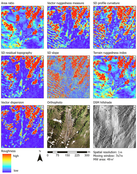
Surface roughness plays a great role in natural hazard processes but is not always well implemented in natural hazard modelling. The results of our study show how surface roughness can be useful in representing vegetation and ground structures, which are currently underrated. By including surface roughness in natural hazard modelling, we could better illustrate the processes and thus improve hazard mapping, which is crucial for infrastructure and settlement planning in mountainous areas.
Nora Helbig, Michael Schirmer, Jan Magnusson, Flavia Mäder, Alec van Herwijnen, Louis Quéno, Yves Bühler, Jeff S. Deems, and Simon Gascoin
The Cryosphere, 15, 4607–4624, https://doi.org/10.5194/tc-15-4607-2021, https://doi.org/10.5194/tc-15-4607-2021, 2021
Short summary
Short summary
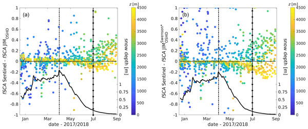
The snow cover spatial variability in mountains changes considerably over the course of a snow season. In applications such as weather, climate and hydrological predictions the fractional snow-covered area is therefore an essential parameter characterizing how much of the ground surface in a grid cell is currently covered by snow. We present a seasonal algorithm and a spatiotemporal evaluation suggesting that the algorithm can be applied in other geographic regions by any snow model application.
Cited articles
Alpert, P.: Mesoscale Indexing of the Distribution of Orographic Precipitation over High Mountains, J. Clim. Appl. Meteorol., 25, 532–545, https://doi.org/10.1175/1520-0450(1986)025<0532:miotdo>2.0.co;2, 1986.
Arakawa, O. and Kitoh, A.: Intercomparison of the relationship between precipitation and elevation among gridded precipitation datasets over the Asian summer monsoon region, Global Environ. Res, 15, 109–118, 2011.
Asaoka, Y. and Kominami, Y.: Spatial snowfall distribution in mountainous areas estimated with a snow model and satellite remote sensing, Hydrol. Res. Lett., 6, 1–6, 2012.
Basist, A., Bell, G. D., and Meentemeyer, V.: Statistical Relationships between Topography and Precipitation Patterns, J. Climate, 7, 1305–1315, https://doi.org/10.1175/1520-0442(1994)007<1305:srbtap>2.0.co;2, 1994.
Bavera, D. and De Michele, C.: Snow water equivalent estimation in the Mallero basin using snow gauge data and MODIS images and fieldwork validation, Hydrol Proc., 23, 1961–1972, https://doi.org/10.1002/hyp.7328, 2009.
Bernhardt, M. and Schulz, K.: SnowSlide: A simple routine for calculating gravitational snow transport, Geophys. Res. Lett., 37, https://doi.org/10.1029/2010gl043086, 2010.
Blanchet, J., Marty, C., and Lehning, M.: Extreme value statistics of snowfall in the Swiss Alpine region, Water Resour. Res., 45, 12, https://doi.org/10.1029/2009wr007916, 2009.
Blöschl, G.: Scaling issues in snow hydrology, Hydrol. Proc., 13, 2149–2175, 1999.
Blumer, F.: Höhenabhängigkeit des Niederschlags im Alpenraum, Ph.D. thesis, 1994.
Bollmann, E., Sailer, R., Briese, C., Stotter, J., and Fritzmann, P.: Potential of airborne laser scanning for geomorphologic feature and process detection and quantifications in high alpine mountains, Zeitschrift für Geomorphologie, 55, 83–104, https://doi.org/10.1127/0372-8854/2011/0055s2-0047, 2011.
Bühler, Y., Hüni, A., Christen, M., Meister, R., and Kellenberger, T.: Automated detection and mapping of avalanche deposits using airborne optical remote sensing data, Cold Regions Sci. Technol., 57, 99–106, https://doi.org/10.1016/j.coldregions.2009.02.007, 2009.
Bühler, Y., Marty, M., and Ginzler, C.: High Resolution DEM Generation in High-Alpine Terrain Using Airborne Remote Sensing Techniques, Transactions in GIS, 16, 635–647, https://doi.org/10.1111/j.1467-9671.2012.01331.x, 2012.
Bühler, Y., Marty, M., Egli, L., Veitinger, J., Jonas, T., Thee, P., and Ginzler, C.: Spatially continuous mapping of snow depth in high alpine catchments using digital photogrammetry, The Cryosphere Discuss., 2014.
Burns, J. I.: Small-scale topographic effects on precipitation distribution in San Dimas experimental forest, Eos, Trans. Am. Geophys. Union, 34, 761–768, https://doi.org/10.1029/TR034i005p00761, 1953.
Carruthers, D. J. and Choularton, T. W.: A model of the feeder-seeder mechanism of orographic rain including stratification and wind-drift effects, Q. J. Roy. Meteor. Soc., 109, 575–588, https://doi.org/10.1002/qj.49710946109, 1983.
Colle, B. A.: Sensitivity of Orographic Precipitation to Changing Ambient Conditions and Terrain Geometries: An Idealized Modeling Perspective, J. Atmos. Sci., 61, 588–606, https://doi.org/10.1175/1520-0469(2004)061<0588:sooptc>2.0.co, 2004.
Dadic, R., Mott, R., Lehning, M., and Burlando, P.: Wind influence on snow depth distribution and accumulation over glaciers, J. Geophys. Res.-Earth, 115, 8, https://doi.org/10.1029/2009JF001261, 2010a.
Dadic, R., Mott, R., Lehning, M., and Burlando, P.: Parameterization for wind-induced preferential deposition of snow, Hydrol. Proc., 24, 1994–2006, https://doi.org/10.1002/hyp.7776, 2010b.
Daly, C., Halbleib, M., Smith, J. I., Gibson, W. P., Doggett, M. K., Taylor, G. H., Curtis, J., and Pasteris, P. P.: Physiographically sensitive mapping of climatological temperature and precipitation across the conterminous United States, Int. J. Climatol., 28, 2031–2064, https://doi.org/10.1002/Joc.1688, 2008.
Deems, J. S. and Painter, T. H.: Lidar measurement of snow depth: Accuracy and error sources., Proceedings International Snow Science Workshop ISSW 2006, Telluride, CO, Proceedings International Snow Science Workshop ISSW, 384–391, 2006.
Deems, J. S., Fassnacht, S. R., and Elder, K. J.: Fractal Distribution of Snow Depth from Lidar Data, Journal of Hydrometeorology, 7, 285–297, 2006.
Deems, J. S., Fassnacht, S. R., and Elder, K. J.: Interannual Consistency in Fractal Snow Depth Patterns at Two Colorado Mountain Sites, Journal of Hydrometeorology, 9, 977–988, https://doi.org/10.1175/2008jhm901.1, 2008.
Deems, J. S., Painter, T. H., and Finnegan, D. C.: Lidar measurement of snow depth: a review, J. Glaciol., 59, 467–479, https://doi.org/10.3189/2013JoG12J154, 2013.
Durand, Y., Giraud, G., Laternser, M., Etchevers, P., Mèrindol, L., and Lesaffre, B.: Reanalysis of 47 Years of Climate in the French Alps (1958-2005): Climatology and Trends for Snow Cover, J. Appl. Meteorol. Clim., 48, 2487–2512, https://doi.org/10.1175/2009jamc1810.1, 2009.
Elder, K., Dozier, J., and Michaelsen, J.: Snow Accumulation and Distribution in an Alpine Watershed, Water Resour. Res., 27, 1541–1552, https://doi.org/10.1029/91wr00506, 1991.
Frei, C. and Schär, C.: A precipitation climatology of the Alps from high-resolution rain-gauge observations, Int. J. Climatol., 18, 873–900, 1998.
Gauer, P.: Numerical modeling of blowing and drifting snow in Alpine terrain, J. Glaciol., 47, 97–110, 2001.
Geist, T. and Stötter, J.: Documentation of glacier surface elevation change with multi-temporal airborne laser scanner data - case study: Hintereisferner and Kesselwandferner, Tyrol, Austria., Zeitschrift für Gletscherkunde und Glazialgeologie, 41, 77–106, 2008.
Gruber, S.: A mass-conserving fast algorithm to parameterize gravitational transport and deposition using digital elevation models, Water Resour. Res., 43, W06 412, https://doi.org/10.1029/2006wr004868, 2007.
Grünewald, T. and Lehning, M.: Altitudinal dependency of snow amounts in two small alpine catchments: can catchment-wide snow amounts be estimated via single snow or precipitation stations?, Ann. Glaciol., 52, 153–158, 2011.
Grünewald, T. and Lehning, M.: Are flat-field snow depth measurements representative? A comparison of selected index sites with areal snow depth measurements at the small catchment scale, Hydrol. Proc., n/a–n/a, https://doi.org/10.1002/hyp.10295, 2014.
Grünewald, T., Schirmer, M., Mott, R., and Lehning, M.: Spatial and temporal variability of snow depth and ablation rates in a small mountain catchment, The Cryosphere, 4, 215–225, https://doi.org/10.5194/tc-4-215-2010, 2010.
Grünewald, T., Stötter, J., Pomeroy, J. W., Dadic, R., Moreno Baños, I., Marturià, J., Spross, M., Hopkinson, C., Burlando, P., and Lehning, M.: Statistical modelling of the snow depth distribution in open alpine terrain, Hydrol. Earth Syst. Sci., 17, 3005–3021, https://doi.org/10.5194/hess-17-3005-2013, 2013.
Havlik, D.: Die Höhenstufe maximaler Niederschlagssummen in den Westalpen, Freiburger Geographische Hefte, 7, 76, 1969.
Helfricht, K., Schöber, J., Schneider, K., Sailer, R., and Kuhn, M.: Inter-annual persistence of the seasonal snow cover in a glacierized catchment, J. Glaciol., 60, 889–904, https://doi.org/10.3189/2014JoG13J197, 2014.
Holko, L.: Evaluation of long-term snow cover data in a mountain catchment, Acta Hydrologica Slovaca, 1, 15, 2000.
Hopkinson, C., Sitar, M., Chasmer, L., and Treitz, P.: Mapping snowpack depth beneath forest canopies using airborne lidar, Photogramm. Eng. Rem. S., 70, 323–330, 2004.
Hopkinson, C., Collins, T., Anderson, A., Pomeroy, J., and Spooner, I.: Spatial Snow Depth Assessment Using LiDAR Transect Samples and Public GIS Data Layers in the Elbow River Watershed, Alberta, Can. Water Resour. J., 37, 69–87, https://doi.org/10.4296/cwrj3702893, 2012.
Houze, R. A.: Orographic effects on precipitating clouds, Rev. Geophys., 50, RG1001, https://doi.org/10.1029/2011rg000365, 2012.
Johnson, G. L. and Hanson, C. L.: Topographic and Atmospheric Influences on Precipitation Variability over a Mountainous Watershed, J. Appl. Meteorol., 34, 68–87, https://doi.org/10.1175/1520-0450-34.1.68, 1995.
Kerr, T., Clark, M., Hendrikx, J., and Anderson, B.: Snow distribution in a steep mid-latitude alpine catchment, Adv. Water Resour., 55, 17–24, https://doi.org/10.1016/j.advwatres.2012.12.010, 2013.
Kirchner, P. B., Bales, R. C., Molotch, N. P., Flanagan, J., and Guo, Q.: LiDAR measurement of seasonal snow accumulation along an elevation gradient in the southern Sierra Nevada, California, Hydrol. Earth Syst. Sci., 18, 4261–4275, https://doi.org/10.5194/hess-18-4261-2014, 2014.
Lauscher, F.: Weltweite Typen der Höhenabhängigkeit des Niederschlags, Wetter und Leben, 28, 80–90, 1976.
Lehning, M., Löwe, H., Ryser, M., and Raderschall, N.: Inhomogeneous precipitation distribution and snow transport in steep terrain, Water Resour. Res., 44, W07404, https://doi.org/10.1029/2007wr006545, 2008.
Lehning, M., Gruenewald, T., and Schirmer, M.: Mountain snow distribution governed by an altitudinal gradient and terrain roughness, Geophys. Res. Lett., 38, https://doi.org/10.1029/2011GL048927, 2011.
Liu, C., Ikeda, K., Thompson, G., Rasmussen, R., and Dudhia, J.: High-Resolution Simulations of Wintertime Precipitation in the Colorado Headwaters Region: Sensitivity to Physics Parameterizations, Monthly Weather Rev., 139, 3533–3553, https://doi.org/10.1175/mwr-d-11-00009.1, 2011.
Lopez-Moreno, J. I. and Stähli, M.: Statistical analysis of the snow cover variability in a subalpine watershed: Assessing the role of topography and forest, interactions, J. Hydrol., 348, 379–394, https://doi.org/10.1016/j.jhydrol.2007.10.018, 2008.
Maune, D.: Digital Elevation Model Technologies and Applications: The DEM Users Manual, American Society for Photogrammetry and Remote Sensing, 2001.
Moreno Baños, I., , Ruiz Garcia, A., Marturià, Alavedra, J., Oller I Figueras, P., Pina Iglesias, J., Garcia Selles, C., Martinez I Figueras, P., and Talaya Lopez, J.: Snowpack depth modelling and water availability from LIDAR measurements in eastern Pyrenees, 2009.
Mott, R., Schirmer, M., Bavay, M., Grünewald, T., and Lehning, M.: Understanding snow-transport processes shaping the mountain snow-cover, The Cryosphere, 4, 545–559, https://doi.org/10.5194/tc-4-545-2010, 2010.
Mott, R., Scipion, D., Schneebeli, M., Dawes, N., Berne, A., and Lehning, M.: Orographic effects on snow deposition patterns in mountainous terrain, J. Geophys. Res.-Atmos., 119, 1419–1439, https://doi.org/10.1002/2013jd019880, 2014.
Peck, E. L. and Brown, M. J.: An approach to the development of isohyetal maps for mountainous areas, J. Geophys. Res., 67, 681–694, https://doi.org/10.1029/JZ067i002p00681, 1962.
Rasmussen, R., Dixon, M., Hage, F., Cole, J., Wade, C., Tuttle, L., McGettigan, S., Carty, T., Stevenson, L., Fellner, W., Knight, S., Karplus, E., and Rehak, N.: Weather support to deicing decision making (WSDDM): A winter weather nowcasting system, Bull. Am. Meteorol. Soc., 82, 579–595, 2001.
Rasmussen, R. M., Hallett, J., Purcell, R., Landolt, S. D., and Cole, J.: The Hotplate Precipitation Gauge, J. Atmos. Ocean. Technol., 28, 148–164, https://doi.org/10.1175/2010jtecha1375.1, 2011.
Robichaud, A. J. and Austin, G. L.: On the modelling of warm orographic rain by the seeder-feeder mechanism, Q. J. Roy. Meteor. Soc., 114, 967–988, https://doi.org/10.1002/qj.49711448207, 1988.
Roe, G. H.: Orographic precipitation, Annu. Rev. Earth Planet. Sci., 33, 645–671, 2005.
Roe, G. H. and Baker, M. B.: Microphysical and Geometrical Controls on the Pattern of Orographic Precipitation, J. Atmos. Sci., 63, 861–880, https://doi.org/10.1175/jas3619.1, 2006.
Rohrer, M., Braun, L., and Lang, H.: Long-Term Records of Snow Cover Water Equivalent in the Swiss Alps 1. Analysis, Nordic Hydrology, 25, 53–64, 1994.
Sandau, R.: Digital Airborne Camera. Introduction and Technology, Springer, Heidelberg, Germany, 2010.
Schirmer, M., Wirz, V., Clifton, A., and Lehning, M.: Persistence in intra-annual snow depth distribution: 1 Measurements and topographic control, Water Resour. Res., 47, W09516, https://doi.org/10.1029/2010wr009426, 2011.
Scipion, D. E., Mott, R., Lehning, M., Schneebeli, M., and Berne, A.: Seasonal small-scale spatial variability in alpine snowfall and snow accumulation, Water Resour. Res., 49, 1446–1457, https://doi.org/10.1002/wrcr.20135, 2013.
Sevruk, B.: Regional dependency of precipitation-altitude relationship in the Swiss Alps, Clim. Change, 36, 355–369, 1997.
Shook, K. and Gray, D. M.: Small-scale spatial structure of shallow snowcovers, Hydrol. Proc., 10, 1283–1292, 1996.
Spreen, W.: A determination of the effect of topography upon precipitation, Transactions, American Geophysical Union, 28, 285–290, https://doi.org/10.1029/TR028i002p00285, 1947.
Trujillo, E., Ramirez, J. A., and Elder, K. J.: Topographic, meteorologic, and canopy controls on the scaling characteristics of the spatial distribution of snow depth fields, Water Resour. Res., 43, 1–17, https://doi.org/10.1029/2006WR005317, 2007.
Trujillo, E., Ramirez, J. A., and Elder, K. J.: Scaling properties and spatial organization of snow depth fields in sub-alpine forest and alpine tundra, Hydrol. Proc., 23, 1575–1590, https://doi.org/10.1002/Hyp.7270, 2009.
Turcan, J.: Snow storage distribution in mountain watersheds, Proceedings of the Moscow Snow and Ice-Symposium – Neige et Glaces, Moscow, Russia, August 1971, IAHS-AISH Publ, 104, 335–340, 1975.
Wastl, C. and Zängl, G.: Analysis of mountain-valley precipitation differences in the Alps, Meteorologische Zeitschrift, 17, 311–321, https://doi.org/10.1127/0941-2948/2008/0291, 2008.
Watson, F. G. R., Anderson, T. N., Newman, W. B., Alexander, S. E., and Garrott, R. A.: Optimal sampling schemes for estimating mean snow water equivalents in stratified heterogeneous landscapes, J. Hydrol., 328, 432–452, https://doi.org/10.1016/j.jhydrol.2005.12.032, 2006.
Yang, D. Q., Goodison, B. E., Metcalfe, J. R., Golubev, V. S., Bates, R., Pangburn, T., and Hanson, C. L.: Accuracy of NWS 8 standard nonrecording precipitation gauge: Results and application of WMO intercomparison, J. Atmos. Ocean. Technol., 15, 54–68, 1998.
Zängl, G.: The temperature dependence of small-scale orographic precipitation enhancement, Q. J. Roy. Meteor. Soc., 134, 1167–1181, https://doi.org/10.1002/qj.267, 2008.
Zängl, G., Aulehner, D., Wastl, C., and Pfeiffer, A.: Small-scale precipitation variability in the Alps: Climatology in comparison with semi-idealized numerical simulations, Q. J. Roy. Meteor. Soc., 134, 1865–1880, https://doi.org/10.1002/qj.311, 2008.
Short summary
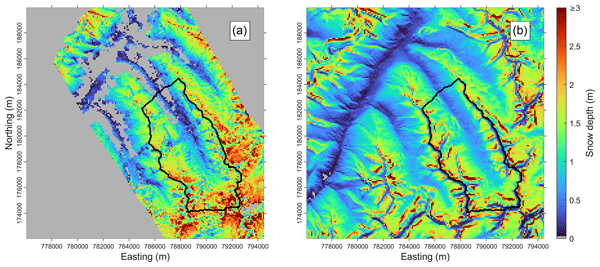
Elevation dependencies of snow depth are analysed based on snow depth maps obtained from airborne remote sensing. Elevation gradients are characterised by a specific shape: an increase of snow depth with elevation is followed by a distinct peak at a certain level and a decrease in the highest elevations. We attribute this shape to an increase of precipitation with altitude, which is modified by topographical-induced redistribution processes of the snow on the ground (wind, gravitation).
Elevation dependencies of snow depth are analysed based on snow depth maps obtained from...


