
Articles | Volume 13, issue 7
https://doi.org/10.5194/tc-13-1801-2019
© Author(s) 2019. This work is distributed under
the Creative Commons Attribution 4.0 License.
the Creative Commons Attribution 4.0 License.
https://doi.org/10.5194/tc-13-1801-2019
© Author(s) 2019. This work is distributed under
the Creative Commons Attribution 4.0 License.
the Creative Commons Attribution 4.0 License.
Research article
| 
08 Jul 2019
Research article |
| 08 Jul 2019
| 08 Jul 2019
Antarctic ice shelf thickness change from multimission lidar mapping
Tyler C. Sutterley
CORRESPONDING AUTHOR
NASA Goddard Space Flight Center, Greenbelt, MD 20771, USA
Thorsten Markus
NASA Goddard Space Flight Center, Greenbelt, MD 20771, USA
Thomas A. Neumann
NASA Goddard Space Flight Center, Greenbelt, MD 20771, USA
Michiel van den Broeke
Institute for Marine and Atmospheric Research, Utrecht University, Utrecht, the Netherlands
J. Melchior van Wessem
Institute for Marine and Atmospheric Research, Utrecht University, Utrecht, the Netherlands
Stefan R. M. Ligtenberg
Institute for Marine and Atmospheric Research, Utrecht University, Utrecht, the Netherlands
Related authors
Benjamin E. Smith, Michael Studinger, Tyler Sutterley, Zachary Fair, and Thomas Neumann
The Cryosphere, 19, 975–995, https://doi.org/10.5194/tc-19-975-2025, https://doi.org/10.5194/tc-19-975-2025, 2025
Short summary
Short summary
This study investigates errors (biases) that may result when green lasers are used to measure the elevation of glaciers and ice sheets. These biases are important because if the snow or ice on top of the ice sheet changes, it can make the elevation of the ice appear to change by the wrong amount. We measure these biases over the Greenland Ice Sheet with a laser system on an airplane and explore how the use of satellite data can let us correct for the biases.
Michael Studinger, Benjamin E. Smith, Nathan Kurtz, Alek Petty, Tyler Sutterley, and Rachel Tilling
The Cryosphere, 18, 2625–2652, https://doi.org/10.5194/tc-18-2625-2024, https://doi.org/10.5194/tc-18-2625-2024, 2024
Short summary
Short summary
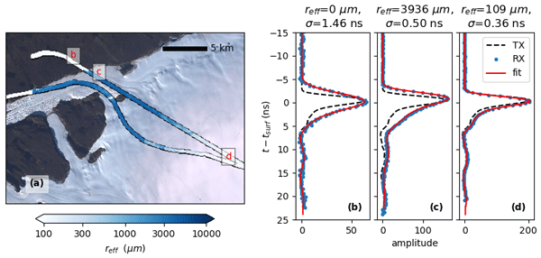
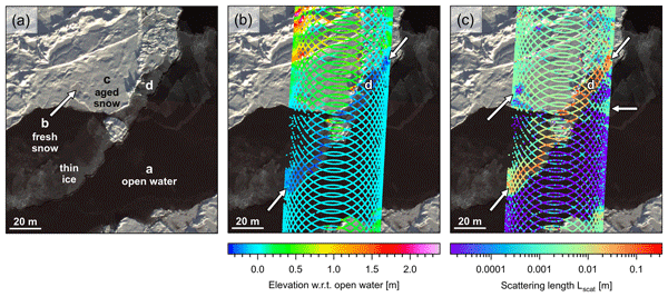
We use green lidar data and natural-color imagery over sea ice to quantify elevation biases potentially impacting estimates of change in ice thickness of the polar regions. We complement our analysis using a model of scattering of light in snow and ice that predicts the shape of lidar waveforms reflecting from snow and ice surfaces based on the shape of the transmitted pulse. We find that biased elevations exist in airborne and spaceborne data products from green lidars.
Inès N. Otosaka, Andrew Shepherd, Erik R. Ivins, Nicole-Jeanne Schlegel, Charles Amory, Michiel R. van den Broeke, Martin Horwath, Ian Joughin, Michalea D. King, Gerhard Krinner, Sophie Nowicki, Anthony J. Payne, Eric Rignot, Ted Scambos, Karen M. Simon, Benjamin E. Smith, Louise S. Sørensen, Isabella Velicogna, Pippa L. Whitehouse, Geruo A, Cécile Agosta, Andreas P. Ahlstrøm, Alejandro Blazquez, William Colgan, Marcus E. Engdahl, Xavier Fettweis, Rene Forsberg, Hubert Gallée, Alex Gardner, Lin Gilbert, Noel Gourmelen, Andreas Groh, Brian C. Gunter, Christopher Harig, Veit Helm, Shfaqat Abbas Khan, Christoph Kittel, Hannes Konrad, Peter L. Langen, Benoit S. Lecavalier, Chia-Chun Liang, Bryant D. Loomis, Malcolm McMillan, Daniele Melini, Sebastian H. Mernild, Ruth Mottram, Jeremie Mouginot, Johan Nilsson, Brice Noël, Mark E. Pattle, William R. Peltier, Nadege Pie, Mònica Roca, Ingo Sasgen, Himanshu V. Save, Ki-Weon Seo, Bernd Scheuchl, Ernst J. O. Schrama, Ludwig Schröder, Sebastian B. Simonsen, Thomas Slater, Giorgio Spada, Tyler C. Sutterley, Bramha Dutt Vishwakarma, Jan Melchior van Wessem, David Wiese, Wouter van der Wal, and Bert Wouters
Earth Syst. Sci. Data, 15, 1597–1616, https://doi.org/10.5194/essd-15-1597-2023, https://doi.org/10.5194/essd-15-1597-2023, 2023
Short summary
Short summary
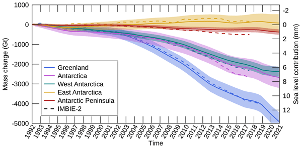
By measuring changes in the volume, gravitational attraction, and ice flow of Greenland and Antarctica from space, we can monitor their mass gain and loss over time. Here, we present a new record of the Earth’s polar ice sheet mass balance produced by aggregating 50 satellite-based estimates of ice sheet mass change. This new assessment shows that the ice sheets have lost (7.5 x 10¹²) t of ice between 1992 and 2020, contributing 21 mm to sea level rise.

Benjamin E. Smith, Brooke Medley, Xavier Fettweis, Tyler Sutterley, Patrick Alexander, David Porter, and Marco Tedesco
The Cryosphere, 17, 789–808, https://doi.org/10.5194/tc-17-789-2023, https://doi.org/10.5194/tc-17-789-2023, 2023
Short summary
Short summary
We use repeated satellite measurements of the height of the Greenland ice sheet to learn about how three computational models of snowfall, melt, and snow compaction represent actual changes in the ice sheet. We find that the models do a good job of estimating how the parts of the ice sheet near the coast have changed but that two of the models have trouble representing surface melt for the highest part of the ice sheet. This work provides suggestions for how to better model snowmelt.
Karen E. Alley, Christian T. Wild, Adrian Luckman, Ted A. Scambos, Martin Truffer, Erin C. Pettit, Atsuhiro Muto, Bruce Wallin, Marin Klinger, Tyler Sutterley, Sarah F. Child, Cyrus Hulen, Jan T. M. Lenaerts, Michelle Maclennan, Eric Keenan, and Devon Dunmire
The Cryosphere, 15, 5187–5203, https://doi.org/10.5194/tc-15-5187-2021, https://doi.org/10.5194/tc-15-5187-2021, 2021
Short summary
Short summary
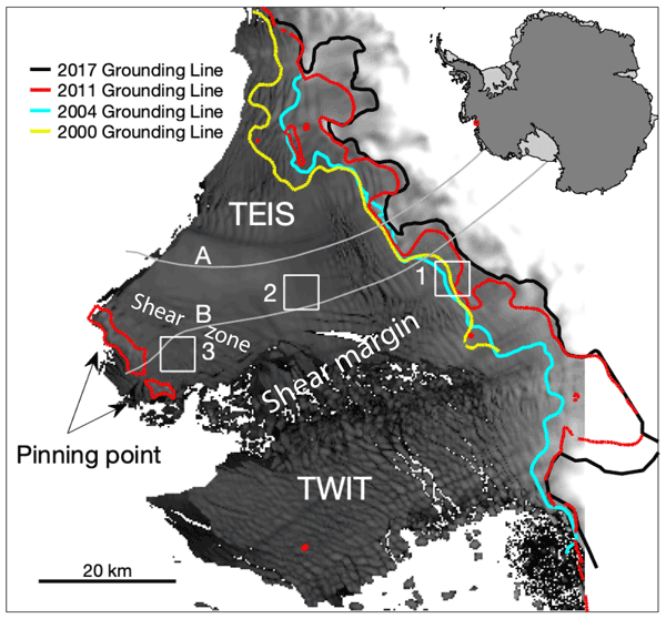
We present a 20-year, satellite-based record of velocity and thickness change on the Thwaites Eastern Ice Shelf (TEIS), the largest remaining floating extension of Thwaites Glacier (TG). TG holds the single greatest control on sea-level rise over the next few centuries, so it is important to understand changes on the TEIS, which controls much of TG's flow into the ocean. Our results suggest that the TEIS is progressively destabilizing and is likely to disintegrate over the next few decades.
Marte Gé Hofsteenge, Willem Jan van de Berg, Christiaan van Dalum, Kristiina Verro, Maurice van Tiggelen, and Michiel van den Broeke
The Cryosphere, 20, 4747–4766, https://doi.org/10.5194/tc-20-4747-2026, https://doi.org/10.5194/tc-20-4747-2026, 2026
Short summary
Short summary
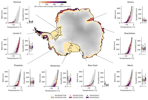
We use a regional climate model to study how surface melt on Antarctic ice shelves responds to air temperature. The relationship is strongly non-linear, mainly due to feedbacks in surface albedo, with other energy sources also contributing. Currently colder, drier, and more stable ice shelves will experience more melt at the same temperature than ice shelves in wetter climates, highlighting their vulnerability to fracturing, ice shelf instability, and contributions to global sea-level rise.
Sanne B. M. Veldhuijsen, Peter Kuipers Munneke, Willem Jan van de Berg, Michiel R. van den Broeke, and Luke D. Trusel
EGUsphere, https://doi.org/10.5194/egusphere-2026-3453, https://doi.org/10.5194/egusphere-2026-3453, 2026
This preprint is open for discussion and under review for The Cryosphere (TC).
Short summary
Short summary
Antarctica has floating ice shelves around its perimeter that provide stability to the ice sheet. As temperature rises, snow on the ice shelves may melt away, and ponding of meltwater may cause the ice shelves to collapse. If that happens, Antarctica may start to lose ice faster than before, resulting in accelerated sea-level rise. The tool presented in this article will be used in simulations of future climate to determine when climate change leads to collapse of the ice shelves in Antarctica.
Fredrik Boberg, Xavier Fettweis, Nicolaj Hansen, Ruth Mottram, and Michiel R. van den Broeke
The Cryosphere, 20, 2947–2960, https://doi.org/10.5194/tc-20-2947-2026, https://doi.org/10.5194/tc-20-2947-2026, 2026
Short summary
Short summary
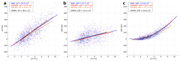
An ensemble of regional climate model simulations is used to estimate the 21st century change in precipitation on the Greenland ice sheet. For the end of the century, the change is in the range 40 to 170 Gt per year, depending on the emission scenario. Using annual values of 2 m air temperature and precipitation, we estimate an increase in precipitation of 35 Gt per year for every degree of warming.
Samuel M. Tax, Maurice van Tiggelen, Thirza N. Feenstra, Paul C. J. P. Smeets, Srinidhi N. Gadde, Christiaan T. van Dalum, Willem Jan van de Berg, and Michiel R. van den Broeke
EGUsphere, https://doi.org/10.5194/egusphere-2026-1926, https://doi.org/10.5194/egusphere-2026-1926, 2026
Short summary
Short summary
Strong winds can lift snow into the air, which influences the energy exchange between the surface and the atmosphere. We studied this phenomenon over the Greenland Ice Sheet using observations and a climate model. We found that blowing snow traps heat near the surface like a blanket and reflects incoming sunlight like a mirror. Simulating these processes increases the net energy at the surface and improves model accuracy. Therefore, we recommend including these effects in climate models.
Benjamin Heurgue, Charles Amory, Christoph Kittel, Fredrik Boberg, Gaël Durand, Vincent Favier, Xavier Fettweis, Quentin Glaude, Heiko Goelzer, Nicolaj Hansen, Nicolas C. Jourdain, Ruth Mottram, Martin Olesen, Willem Jan Van de Berg, Michiel R. Van den Broeke, and René R. Wijngaard
EGUsphere, https://doi.org/10.5194/egusphere-2026-624, https://doi.org/10.5194/egusphere-2026-624, 2026
Short summary
Short summary
We studied how the Antarctic ice sheet surface mass balance may change by 2100 using three high-resolution climate models forced by the same future climate scenario. While the models agree for present-day conditions, they project very different futures, especially over floating ice shelves. These differences mainly come from how melting, refreezing, and temperature are represented. Our results show that future sea level projections strongly depend on how well models simulate today’s climate.
Tesse E. A. van den Aker, Peter Kuipers Munneke, Willem Jan van de Berg, Walter W. Immerzeel, and Michiel R. van den Broeke
EGUsphere, https://doi.org/10.5194/egusphere-2026-462, https://doi.org/10.5194/egusphere-2026-462, 2026
Short summary
Short summary
The firn layer, i.e. permanent snow, regulates how an ice sheet responds to climate change. Firn models are forced with with climate data at time steps from sub-daily to annual in literature, however, implications are barely evaluated. We test the impact of different climate forcing time steps on the modeled firn layer. We conclude that the climate forcing time step (1) affects firn model output, (2) can lead to non-physical behaviour, and (3) that resolving at least a diurnal cycle is required.
Thirza N. Feenstra, Willem Jan van de Berg, Gerd-Jan van Zadelhoff, David P. Donovan, Christiaan T. van Dalum, and Michiel R. van den Broeke
Atmos. Meas. Tech., 19, 1323–1344, https://doi.org/10.5194/amt-19-1323-2026, https://doi.org/10.5194/amt-19-1323-2026, 2026
Short summary
Short summary
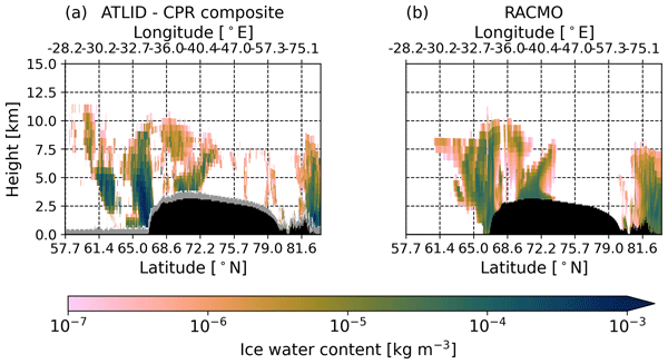
Cloud representation brings large uncertainties in polar climate modeling. We show the first evaluation of Greenland clouds in the Regional Atmospheric Climate Model (RACMO2.4) with new EarthCARE satellite data. Comparing lidar and radar observations and retrieved cloud profiles with co-located RACMO output, we find RACMO captures low ice clouds but underestimates high clouds, mid-altitude liquid clouds, and snowfall. These results highlight EarthCARE's potential to improve polar climate models.
Ida Haven, Hans Christian Steen-Larsen, Laura J. Dietrich, Sonja Wahl, Jason E. Box, Michiel R. van den Broeke, Alun Hubbard, Stephan T. Kral, Joachim Reuder, and Maurice van Tiggelen
The Cryosphere, 20, 573–593, https://doi.org/10.5194/tc-20-573-2026, https://doi.org/10.5194/tc-20-573-2026, 2026
Short summary
Short summary
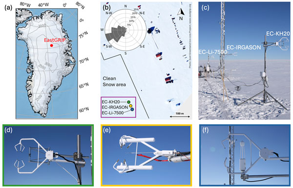
Three independent Eddy-Covariance measurement systems deployed on top of the Greenland Ice Sheet are compared. Using this dataset, we evaluate the reproducibility and quantify the differences between the systems. The fidelity of two regional climate models in capturing the seasonal variability in the latent and sensible heat flux between the snow surface and the atmosphere is assessed. We identify differences between observations and model simulations, especially during the winter period.

Horst Machguth, Andrew Tedstone, Peter Kuipers Munneke, Max Brils, Brice Noël, Nicole Clerx, Nicolas Jullien, Xavier Fettweis, and Michiel van den Broeke
The Cryosphere, 20, 427–452, https://doi.org/10.5194/tc-20-427-2026, https://doi.org/10.5194/tc-20-427-2026, 2026
Short summary
Short summary
Due to increasing air temperatures, surface melt expands to higher elevations on the Greenland ice sheet. This is visible on satellite imagery in the form of rivers of meltwater running across the surface of the ice sheet. We compare model results of meltwater at high elevations on the ice sheet to satellite observations. We find that each of the models shows strengths and weaknesses. A detailed look into the model results reveals potential reasons for the differences between models.
Valeria Di Biase, Peter Kuipers Munneke, Bert Wouters, Michiel R. van den Broeke, and Maurice van Tiggelen
The Cryosphere, 20, 87–96, https://doi.org/10.5194/tc-20-87-2026, https://doi.org/10.5194/tc-20-87-2026, 2026
Short summary
Short summary
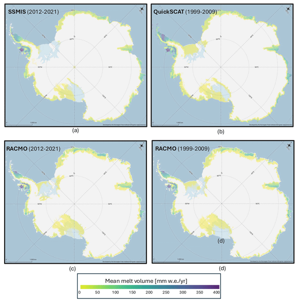
We produce annual maps of Antarctic surface melt volumes from 2012 to 2021 using satellite microwave data. We detect melting days from thresholds on the satellite signal and then use actual melt measurements from weather stations to convert those signals into water‑equivalent volumes. Our maps capture known melt hotspots and show slightly lower totals than climate models. This dataset supports climate and ice‑shelf studies.

Heiko Goelzer, Constantijn J. Berends, Fredrik Boberg, Gael Durand, Tamsin L. Edwards, Xavier Fettweis, Fabien Gillet-Chaulet, Quentin Glaude, Philippe Huybrechts, Sébastien Le clec'h, Ruth Mottram, Brice Noël, Martin Olesen, Charlotte Rahlves, Jeremy Rohmer, Michiel van den Broeke, and Roderik S. W. van de Wal
The Cryosphere, 19, 6887–6906, https://doi.org/10.5194/tc-19-6887-2025, https://doi.org/10.5194/tc-19-6887-2025, 2025
Short summary
Short summary
We present an ensemble of ice sheet model projections for the Greenland ice sheet. The focus is on providing projections that improve our understanding of the range future sea-level rise and the inherent uncertainties over the next 100 to 300 years. Compared to earlier work we more fully account for some of the uncertainties in sea-level projections. We include a wider range of climate model output, more climate change scenarios and we extend projections schematically up to year 2300.
Zachary Fair, Carrie Vuyovich, Thomas Neumann, Justin Pflug, David Shean, Ellyn M. Enderlin, Karina Zikan, Hannah Besso, Jessica Lundquist, Cesar Deschamps-Berger, and Désirée Treichler
The Cryosphere, 19, 5671–5691, https://doi.org/10.5194/tc-19-5671-2025, https://doi.org/10.5194/tc-19-5671-2025, 2025
Short summary
Short summary
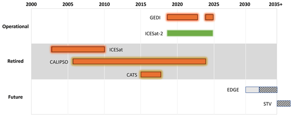
Lidar is commonly used to measure snow over global water reservoirs. However, ground-based and airborne lidar surveys are expensive, so satellite-based methods are needed. In this review, we outline the latest research using satellite-based lidar to monitor snow. Best practices for lidar-based snow monitoring are given, as is a discussion on challenges in this field of research.
Sanne B. M. Veldhuijsen, Willem Jan van de Berg, Peter Kuipers Munneke, Nicolaj Hansen, Fredrik Boberg, Christoph Kittel, Charles Amory, and Michiel R. van den Broeke
The Cryosphere, 19, 5157–5173, https://doi.org/10.5194/tc-19-5157-2025, https://doi.org/10.5194/tc-19-5157-2025, 2025
Short summary
Short summary
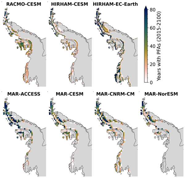
Perennial firn aquifers (PFAs), year-round bodies of liquid water within firns, can potentially impact ice-shelf and ice-sheet stability. We developed a fast XGBoost firn emulator to predict the 21st-century distribution of PFAs in Antarctica for 12 climatic forcing datasets. Our findings suggest that, in low-emission scenarios, PFAs remain confined to the Antarctic Peninsula. However, in a high-emission scenario, PFAs are projected to expand to a region in West Antarctica and East Antarctica.
Christiaan T. van Dalum, Willem Jan van de Berg, Michiel R. van den Broeke, and Maurice van Tiggelen
The Cryosphere, 19, 4061–4090, https://doi.org/10.5194/tc-19-4061-2025, https://doi.org/10.5194/tc-19-4061-2025, 2025
Short summary
Short summary
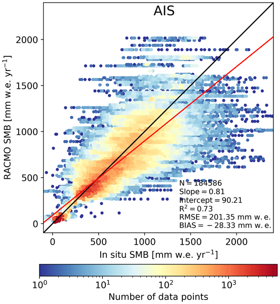
In this study, we present a new surface mass balance (SMB) and near-surface climate product for Antarctica with the regional climate model RACMO2.4p1. We assess the impact of major model updates on the climate of Antarctica. Locally, the SMB has changed substantially but also agrees well with observations. In addition, we show that the SMB components, surface energy budget, albedo, pressure, temperature, and wind speed compare well with in situ and remote sensing observations.
Maurice van Tiggelen, Paul C. J. P. Smeets, Carleen H. Reijmer, Peter Kuipers Munneke, and Michiel R. van den Broeke
Earth Syst. Sci. Data, 17, 4933–4955, https://doi.org/10.5194/essd-17-4933-2025, https://doi.org/10.5194/essd-17-4933-2025, 2025
Short summary
Short summary
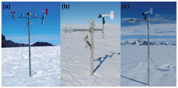
This paper describes the measurements from the 19 IMAU (Institute for Marine and Atmospheric research Utrecht) automatic weather stations that operated on the Antarctic ice sheet from 1995 through 2022. These stations also measured the net surface radiation and surface height change, allowing for the quantification of the surface energy and mass balance at hourly resolution. These data are invaluable for the evaluation of atmospheric models and for the detection of climatological changes.
Anneke L. Vries, Willem Jan van de Berg, Brice Noël, Lorenz Meire, and Michiel R. van den Broeke
The Cryosphere, 19, 3897–3914, https://doi.org/10.5194/tc-19-3897-2025, https://doi.org/10.5194/tc-19-3897-2025, 2025
Short summary
Short summary
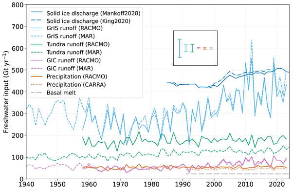
Freshwater flows into Greenland's fjords from various sources. Solid ice discharge (e.g. calving icebergs) dominates freshwater input in the southeast and northwest. In contrast, in the southwest, runoff from the ice sheet and tundra are the most significant. Seasonal data revealed that fjord precipitation and tundra runoff contribute up to 11 % and 35 % of the monthly freshwater input, respectively. Our results provide valuable input for ocean models and for researchers studying fjord ecosystems.
Shfaqat A. Khan, Helene Seroussi, Mathieu Morlighem, William Colgan, Veit Helm, Gong Cheng, Danjal Berg, Valentina R. Barletta, Nicolaj K. Larsen, William Kochtitzky, Michiel van den Broeke, Kurt H. Kjær, Andy Aschwanden, Brice Noël, Jason E. Box, Joseph A. MacGregor, Robert S. Fausto, Kenneth D. Mankoff, Ian M. Howat, Kuba Oniszk, Dominik Fahrner, Anja Løkkegaard, Eigil Y. H. Lippert, Alicia Bråtner, and Javed Hassan
Earth Syst. Sci. Data, 17, 3047–3071, https://doi.org/10.5194/essd-17-3047-2025, https://doi.org/10.5194/essd-17-3047-2025, 2025
Short summary
Short summary
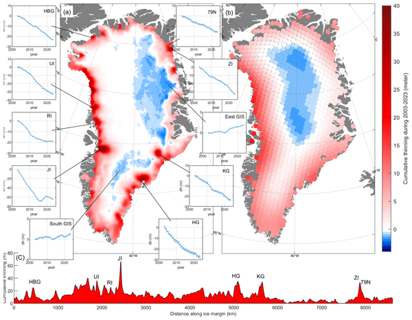
The surface elevation of the Greenland Ice Sheet is changing due to surface mass balance processes and ice dynamics, each exhibiting distinct spatiotemporal patterns. Here, we employ satellite and airborne altimetry data with fine spatial (1 km) and temporal (monthly) resolutions to document this spatiotemporal evolution from 2003 to 2023. This dataset of fine-resolution altimetry data in both space and time will support studies of ice mass loss and be useful for GIS ice sheet modeling.
Benjamin E. Smith, Michael Studinger, Tyler Sutterley, Zachary Fair, and Thomas Neumann
The Cryosphere, 19, 975–995, https://doi.org/10.5194/tc-19-975-2025, https://doi.org/10.5194/tc-19-975-2025, 2025
Short summary
Short summary
This study investigates errors (biases) that may result when green lasers are used to measure the elevation of glaciers and ice sheets. These biases are important because if the snow or ice on top of the ice sheet changes, it can make the elevation of the ice appear to change by the wrong amount. We measure these biases over the Greenland Ice Sheet with a laser system on an airplane and explore how the use of satellite data can let us correct for the biases.
Beata Csatho, Tony Schenk, and Tom Neumann
Int. Arch. Photogramm. Remote Sens. Spatial Inf. Sci., XLVIII-3-2024, 83–88, https://doi.org/10.5194/isprs-archives-XLVIII-3-2024-83-2024, https://doi.org/10.5194/isprs-archives-XLVIII-3-2024-83-2024, 2024
Maria T. Kappelsberger, Martin Horwath, Eric Buchta, Matthias O. Willen, Ludwig Schröder, Sanne B. M. Veldhuijsen, Peter Kuipers Munneke, and Michiel R. van den Broeke
The Cryosphere, 18, 4355–4378, https://doi.org/10.5194/tc-18-4355-2024, https://doi.org/10.5194/tc-18-4355-2024, 2024
Short summary
Short summary
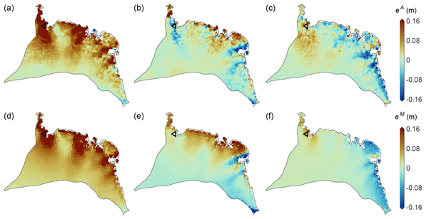
The interannual variations in the height of the Antarctic Ice Sheet (AIS) are mainly due to natural variations in snowfall. Precise knowledge of these variations is important for the detection of any long-term climatic trends in AIS surface elevation. We present a new product that spatially resolves these height variations over the period 1992–2017. The product combines the strengths of atmospheric modeling results and satellite altimetry measurements.
Christiaan T. van Dalum, Willem Jan van de Berg, Srinidhi N. Gadde, Maurice van Tiggelen, Tijmen van der Drift, Erik van Meijgaard, Lambertus H. van Ulft, and Michiel R. van den Broeke
The Cryosphere, 18, 4065–4088, https://doi.org/10.5194/tc-18-4065-2024, https://doi.org/10.5194/tc-18-4065-2024, 2024
Short summary
Short summary
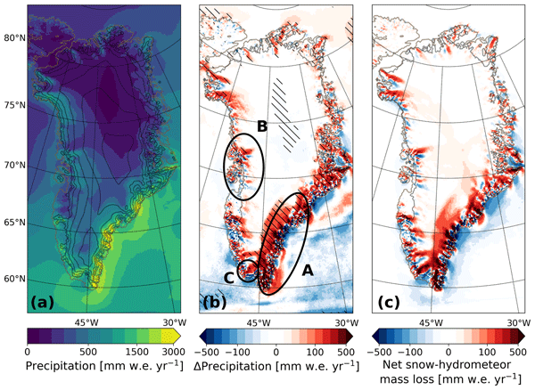
We present a new version of the polar Regional Atmospheric Climate Model (RACMO), version 2.4p1, and show first results for Greenland, Antarctica and the Arctic. We provide an overview of all changes and investigate the impact that they have on the climate of polar regions. By comparing the results with observations and the output from the previous model version, we show that the model performs well regarding the surface mass balance of the ice sheets and near-surface climate.
Michael Studinger, Benjamin E. Smith, Nathan Kurtz, Alek Petty, Tyler Sutterley, and Rachel Tilling
The Cryosphere, 18, 2625–2652, https://doi.org/10.5194/tc-18-2625-2024, https://doi.org/10.5194/tc-18-2625-2024, 2024
Short summary
Short summary
We use green lidar data and natural-color imagery over sea ice to quantify elevation biases potentially impacting estimates of change in ice thickness of the polar regions. We complement our analysis using a model of scattering of light in snow and ice that predicts the shape of lidar waveforms reflecting from snow and ice surfaces based on the shape of the transmitted pulse. We find that biased elevations exist in airborne and spaceborne data products from green lidars.
Sanne B. M. Veldhuijsen, Willem Jan van de Berg, Peter Kuipers Munneke, and Michiel R. van den Broeke
The Cryosphere, 18, 1983–1999, https://doi.org/10.5194/tc-18-1983-2024, https://doi.org/10.5194/tc-18-1983-2024, 2024
Short summary
Short summary
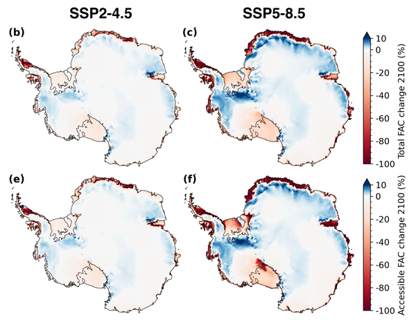
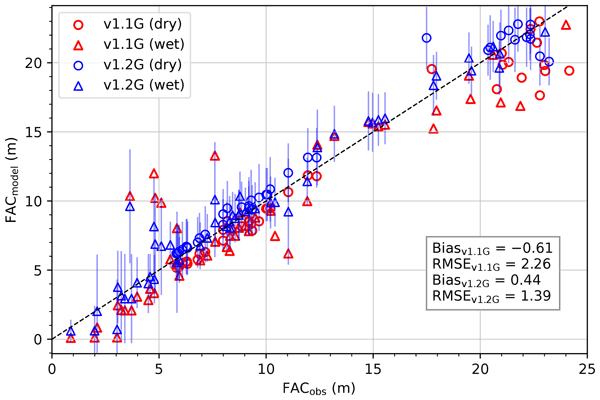
We use the IMAU firn densification model to simulate the 21st-century evolution of Antarctic firn air content. Ice shelves on the Antarctic Peninsula and the Roi Baudouin Ice Shelf in Dronning Maud Land are particularly vulnerable to total firn air content (FAC) depletion. Our results also underline the potentially large vulnerability of low-accumulation ice shelves to firn air depletion through ice slab formation.
Baptiste Vandecrux, Robert S. Fausto, Jason E. Box, Federico Covi, Regine Hock, Åsa K. Rennermalm, Achim Heilig, Jakob Abermann, Dirk van As, Elisa Bjerre, Xavier Fettweis, Paul C. J. P. Smeets, Peter Kuipers Munneke, Michiel R. van den Broeke, Max Brils, Peter L. Langen, Ruth Mottram, and Andreas P. Ahlstrøm
The Cryosphere, 18, 609–631, https://doi.org/10.5194/tc-18-609-2024, https://doi.org/10.5194/tc-18-609-2024, 2024
Short summary
Short summary
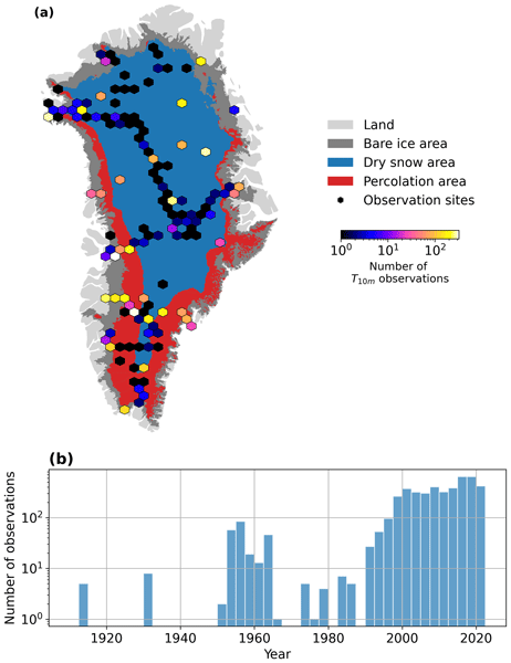
How fast is the Greenland ice sheet warming? In this study, we compiled 4500+ temperature measurements at 10 m below the ice sheet surface (T10m) from 1912 to 2022. We trained a machine learning model on these data and reconstructed T10m for the ice sheet during 1950–2022. After a slight cooling during 1950–1985, the ice sheet warmed at a rate of 0.7 °C per decade until 2022. Climate models showed mixed results compared to our observations and underestimated the warming in key regions.
Lena G. Buth, Valeria Di Biase, Peter Kuipers Munneke, Stef Lhermitte, Sanne B. M. Veldhuijsen, Sophie de Roda Husman, Michiel R. van den Broeke, and Bert Wouters
EGUsphere, https://doi.org/10.5194/egusphere-2023-2000, https://doi.org/10.5194/egusphere-2023-2000, 2023
Preprint archived
Short summary
Short summary
Liquid meltwater which is stored in air bubbles in the compacted snow near the surface of Antarctica can affect ice shelf stability. In order to detect the presence of such firn aquifers over large scales, satellite remote sensing is needed. In this paper, we present our new detection method using radar satellite data as well as the results for the whole Antarctic Peninsula. Firn aquifers are found in the north and northwest of the peninsula, in agreement with locations predicted by models.
Inès N. Otosaka, Andrew Shepherd, Erik R. Ivins, Nicole-Jeanne Schlegel, Charles Amory, Michiel R. van den Broeke, Martin Horwath, Ian Joughin, Michalea D. King, Gerhard Krinner, Sophie Nowicki, Anthony J. Payne, Eric Rignot, Ted Scambos, Karen M. Simon, Benjamin E. Smith, Louise S. Sørensen, Isabella Velicogna, Pippa L. Whitehouse, Geruo A, Cécile Agosta, Andreas P. Ahlstrøm, Alejandro Blazquez, William Colgan, Marcus E. Engdahl, Xavier Fettweis, Rene Forsberg, Hubert Gallée, Alex Gardner, Lin Gilbert, Noel Gourmelen, Andreas Groh, Brian C. Gunter, Christopher Harig, Veit Helm, Shfaqat Abbas Khan, Christoph Kittel, Hannes Konrad, Peter L. Langen, Benoit S. Lecavalier, Chia-Chun Liang, Bryant D. Loomis, Malcolm McMillan, Daniele Melini, Sebastian H. Mernild, Ruth Mottram, Jeremie Mouginot, Johan Nilsson, Brice Noël, Mark E. Pattle, William R. Peltier, Nadege Pie, Mònica Roca, Ingo Sasgen, Himanshu V. Save, Ki-Weon Seo, Bernd Scheuchl, Ernst J. O. Schrama, Ludwig Schröder, Sebastian B. Simonsen, Thomas Slater, Giorgio Spada, Tyler C. Sutterley, Bramha Dutt Vishwakarma, Jan Melchior van Wessem, David Wiese, Wouter van der Wal, and Bert Wouters
Earth Syst. Sci. Data, 15, 1597–1616, https://doi.org/10.5194/essd-15-1597-2023, https://doi.org/10.5194/essd-15-1597-2023, 2023
Short summary
Short summary
By measuring changes in the volume, gravitational attraction, and ice flow of Greenland and Antarctica from space, we can monitor their mass gain and loss over time. Here, we present a new record of the Earth’s polar ice sheet mass balance produced by aggregating 50 satellite-based estimates of ice sheet mass change. This new assessment shows that the ice sheets have lost (7.5 x 10¹²) t of ice between 1992 and 2020, contributing 21 mm to sea level rise.

Sanne B. M. Veldhuijsen, Willem Jan van de Berg, Max Brils, Peter Kuipers Munneke, and Michiel R. van den Broeke
The Cryosphere, 17, 1675–1696, https://doi.org/10.5194/tc-17-1675-2023, https://doi.org/10.5194/tc-17-1675-2023, 2023
Short summary
Short summary
Firn is the transition of snow to glacier ice and covers 99 % of the Antarctic ice sheet. Knowledge about the firn layer and its variability is important, as it impacts satellite-based estimates of ice sheet mass change. Also, firn contains pores in which nearly all of the surface melt is retained. Here, we improve a semi-empirical firn model and simulate the firn characteristics for the period 1979–2020. We evaluate the performance with field and satellite measures and test its sensitivity.
Benjamin E. Smith, Brooke Medley, Xavier Fettweis, Tyler Sutterley, Patrick Alexander, David Porter, and Marco Tedesco
The Cryosphere, 17, 789–808, https://doi.org/10.5194/tc-17-789-2023, https://doi.org/10.5194/tc-17-789-2023, 2023
Short summary
Short summary
We use repeated satellite measurements of the height of the Greenland ice sheet to learn about how three computational models of snowfall, melt, and snow compaction represent actual changes in the ice sheet. We find that the models do a good job of estimating how the parts of the ice sheet near the coast have changed but that two of the models have trouble representing surface melt for the highest part of the ice sheet. This work provides suggestions for how to better model snowmelt.
Marte G. Hofsteenge, Nicolas J. Cullen, Carleen H. Reijmer, Michiel van den Broeke, Marwan Katurji, and John F. Orwin
The Cryosphere, 16, 5041–5059, https://doi.org/10.5194/tc-16-5041-2022, https://doi.org/10.5194/tc-16-5041-2022, 2022
Short summary
Short summary
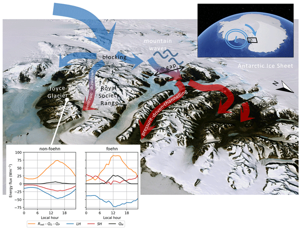
In the McMurdo Dry Valleys (MDV), foehn winds can impact glacial meltwater production and the fragile ecosystem that depends on it. We study these dry and warm winds at Joyce Glacier and show they are caused by a different mechanism than that found for nearby valleys, demonstrating the complex interaction of large-scale winds with the mountains in the MDV. We find that foehn winds increase sublimation of ice, increase heating from the atmosphere, and increase the occurrence and rates of melt.

Brooke Medley, Thomas A. Neumann, H. Jay Zwally, Benjamin E. Smith, and C. Max Stevens
The Cryosphere, 16, 3971–4011, https://doi.org/10.5194/tc-16-3971-2022, https://doi.org/10.5194/tc-16-3971-2022, 2022
Short summary
Short summary
Satellite altimeters measure the height or volume change over Earth's ice sheets, but in order to understand how that change translates into ice mass, we must account for various processes at the surface. Specifically, snowfall events generate large, transient increases in surface height, yet snow fall has a relatively low density, which means much of that height change is composed of air. This air signal must be removed from the observed height changes before we can assess ice mass change.
Lena G. Buth, Bert Wouters, Sanne B. M. Veldhuijsen, Stef Lhermitte, Peter Kuipers Munneke, and Michiel R. van den Broeke
The Cryosphere Discuss., https://doi.org/10.5194/tc-2022-127, https://doi.org/10.5194/tc-2022-127, 2022
Manuscript not accepted for further review
Short summary
Short summary
Liquid meltwater which is stored in air bubbles in the compacted snow near the surface of Antarctica can affect ice shelf stability. In order to detect the presence of such firn aquifers over large scales, satellite remote sensing is needed. In this paper, we present our new detection method using radar satellite data as well as the results for the whole Antarctic Peninsula. Firn aquifers are found in the north and northwest of the peninsula, in agreement with locations predicted by models.
Jeremy Carter, Amber Leeson, Andrew Orr, Christoph Kittel, and J. Melchior van Wessem
The Cryosphere, 16, 3815–3841, https://doi.org/10.5194/tc-16-3815-2022, https://doi.org/10.5194/tc-16-3815-2022, 2022
Short summary
Short summary
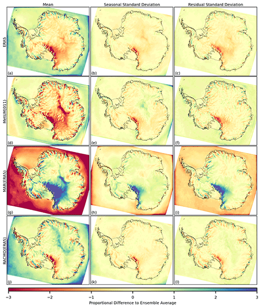
Climate models provide valuable information for studying processes such as the collapse of ice shelves over Antarctica which impact estimates of sea level rise. This paper examines variability across climate simulations over Antarctica for fields including snowfall, temperature and melt. Significant systematic differences between outputs are found, occurring at both large and fine spatial scales across Antarctica. Results are important for future impact assessments and model development.
Max Brils, Peter Kuipers Munneke, Willem Jan van de Berg, and Michiel van den Broeke
Geosci. Model Dev., 15, 7121–7138, https://doi.org/10.5194/gmd-15-7121-2022, https://doi.org/10.5194/gmd-15-7121-2022, 2022
Short summary
Short summary
Firn covers the Greenland ice sheet (GrIS) and can temporarily prevent mass loss. Here, we present the latest version of our firn model, IMAU-FDM, with an application to the GrIS. We improved the density of fallen snow, the firn densification rate and the firn's thermal conductivity. This leads to a higher air content and 10 m temperatures. Furthermore we investigate three case studies and find that the updated model shows greater variability and an increased sensitivity in surface elevation.
Matthew K. Laffin, Charles S. Zender, Melchior van Wessem, and Sebastián Marinsek
The Cryosphere, 16, 1369–1381, https://doi.org/10.5194/tc-16-1369-2022, https://doi.org/10.5194/tc-16-1369-2022, 2022
Short summary
Short summary
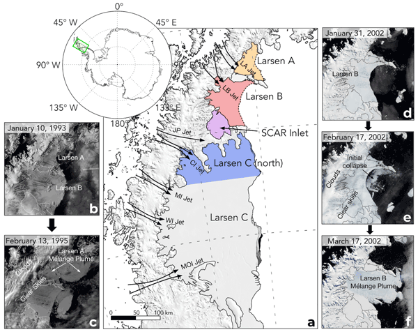
The collapses of the Larsen A and B ice shelves on the Antarctic Peninsula (AP) occurred while the ice shelves were covered with large melt lakes, and ocean waves damaged the ice shelf fronts, triggering collapse. Observations show föhn winds were present on both ice shelves and increased surface melt and drove sea ice away from the ice front. Collapsed ice shelves experienced enhanced surface melt driven by föhn winds, whereas extant ice shelves are affected less by föhn-wind-induced melt.
Christian J. Taubenberger, Denis Felikson, and Thomas Neumann
The Cryosphere, 16, 1341–1348, https://doi.org/10.5194/tc-16-1341-2022, https://doi.org/10.5194/tc-16-1341-2022, 2022
Short summary
Short summary
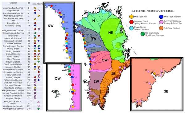
Outlet glaciers are projected to account for half of the total ice loss from the Greenland Ice Sheet over the 21st century. We classify patterns of seasonal dynamic thickness changes of outlet glaciers using new observations from the Ice, Cloud and land Elevation Satellite-2 (ICESat-2). Our results reveal seven distinct patterns that differ across glaciers even within the same region. Future work can use our results to improve our understanding of processes that drive seasonal ice sheet changes.
Christiaan T. van Dalum, Willem Jan van de Berg, and Michiel R. van den Broeke
The Cryosphere, 16, 1071–1089, https://doi.org/10.5194/tc-16-1071-2022, https://doi.org/10.5194/tc-16-1071-2022, 2022
Short summary
Short summary
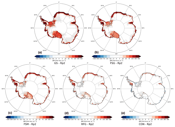
In this study, we improve the regional climate model RACMO2 and investigate the climate of Antarctica. We have implemented a new radiative transfer and snow albedo scheme and do several sensitivity experiments. When fully tuned, the results compare well with observations and snow temperature profiles improve. Moreover, small changes in the albedo and the investigated processes can lead to a strong overestimation of melt, locally leading to runoff and a reduced surface mass balance.
Nicolaj Hansen, Sebastian B. Simonsen, Fredrik Boberg, Christoph Kittel, Andrew Orr, Niels Souverijns, J. Melchior van Wessem, and Ruth Mottram
The Cryosphere, 16, 711–718, https://doi.org/10.5194/tc-16-711-2022, https://doi.org/10.5194/tc-16-711-2022, 2022
Short summary
Short summary
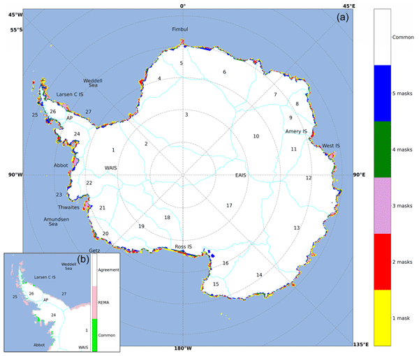
We investigate the impact of different ice masks when modelling surface mass balance over Antarctica. We used ice masks and data from five of the most used regional climate models and a common mask. We see large disagreement between the ice masks, which has a large impact on the surface mass balance, especially around the Antarctic Peninsula and some of the largest glaciers. We suggest a solution for creating a new, up-to-date, high-resolution ice mask that can be used in Antarctic modelling.
Peter A. Tuckett, Jeremy C. Ely, Andrew J. Sole, James M. Lea, Stephen J. Livingstone, Julie M. Jones, and J. Melchior van Wessem
The Cryosphere, 15, 5785–5804, https://doi.org/10.5194/tc-15-5785-2021, https://doi.org/10.5194/tc-15-5785-2021, 2021
Short summary
Short summary
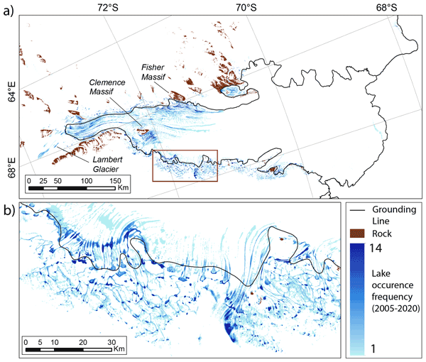
Lakes form on the surface of the Antarctic Ice Sheet during the summer. These lakes can generate further melt, break up floating ice shelves and alter ice dynamics. Here, we describe a new automated method for mapping surface lakes and apply our technique to the Amery Ice Shelf between 2005 and 2020. Lake area is highly variable between years, driven by large-scale climate patterns. This technique will help us understand the role of Antarctic surface lakes in our warming world.
Zhongyang Hu, Peter Kuipers Munneke, Stef Lhermitte, Maaike Izeboud, and Michiel van den Broeke
The Cryosphere, 15, 5639–5658, https://doi.org/10.5194/tc-15-5639-2021, https://doi.org/10.5194/tc-15-5639-2021, 2021
Short summary
Short summary
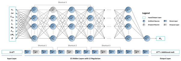
Antarctica is shrinking, and part of the mass loss is caused by higher temperatures leading to more snowmelt. We use computer models to estimate the amount of melt, but this can be inaccurate – specifically in the areas with the most melt. This is because the model cannot account for small, darker areas like rocks or darker ice. Thus, we trained a computer using artificial intelligence and satellite images that showed these darker areas. The model computed an improved estimate of melt.
Karen E. Alley, Christian T. Wild, Adrian Luckman, Ted A. Scambos, Martin Truffer, Erin C. Pettit, Atsuhiro Muto, Bruce Wallin, Marin Klinger, Tyler Sutterley, Sarah F. Child, Cyrus Hulen, Jan T. M. Lenaerts, Michelle Maclennan, Eric Keenan, and Devon Dunmire
The Cryosphere, 15, 5187–5203, https://doi.org/10.5194/tc-15-5187-2021, https://doi.org/10.5194/tc-15-5187-2021, 2021
Short summary
Short summary
We present a 20-year, satellite-based record of velocity and thickness change on the Thwaites Eastern Ice Shelf (TEIS), the largest remaining floating extension of Thwaites Glacier (TG). TG holds the single greatest control on sea-level rise over the next few centuries, so it is important to understand changes on the TEIS, which controls much of TG's flow into the ocean. Our results suggest that the TEIS is progressively destabilizing and is likely to disintegrate over the next few decades.
Kenneth D. Mankoff, Xavier Fettweis, Peter L. Langen, Martin Stendel, Kristian K. Kjeldsen, Nanna B. Karlsson, Brice Noël, Michiel R. van den Broeke, Anne Solgaard, William Colgan, Jason E. Box, Sebastian B. Simonsen, Michalea D. King, Andreas P. Ahlstrøm, Signe Bech Andersen, and Robert S. Fausto
Earth Syst. Sci. Data, 13, 5001–5025, https://doi.org/10.5194/essd-13-5001-2021, https://doi.org/10.5194/essd-13-5001-2021, 2021
Short summary
Short summary
We estimate the daily mass balance and its components (surface, marine, and basal mass balance) for the Greenland ice sheet. Our time series begins in 1840 and has annual resolution through 1985 and then daily from 1986 through next week. Results are operational (updated daily) and provided for the entire ice sheet or by commonly used regions or sectors. This is the first input–output mass balance estimate to include the basal mass balance.
Cited articles
Altamimi, Z., Rebischung, P., Métivier, L., and Collilieux, X.: ITRF2014:
A new release of the International Terrestrial Reference Frame modeling
nonlinear station motions, J. Geophys. Res.-Solid Earth,
121, 6109–6131, https://doi.org/10.1002/2016JB013098, 2016. a
Armitage, T. W. K., Kwok, R., Thompson, A. F., and Cunningham, G.: Dynamic
Topography and Sea Level Anomalies of the Southern Ocean: Variability and
Teleconnections, J. Geophys. Res.-Oceans, 123, 613–630,
https://doi.org/10.1002/2017JC013534, 2018. a
Berger, S., Drews, R., Helm, V., Sun, S., and Pattyn, F.: Detecting high
spatial variability of ice shelf basal mass balance, Roi Baudouin Ice Shelf,
Antarctica, The Cryosphere, 11, 2675–2690, https://doi.org/10.5194/tc-11-2675-2017, 2017. a, b
Berthier, E., Scambos, T. A., and Shuman, C. A.: Mass loss of Larsen B
tributary glaciers (Antarctic Peninsula) unabated since 2002, Geophys.
Res. Lett., 39, l13501, https://doi.org/10.1029/2012GL051755, 2012. a
Blair, J. B. and Hofton, M.: IceBridge LVIS L2 Geolocated Surface Elevation
Product, NASA DAAC at the National Snow and Ice Data Center, Boulder,
Colorado USA, https://doi.org/10.5067/OIKFGJNBM6OO, version
2, 2010. a, b, c
Blair, J. B., Rabine, D. L., and Hofton, M. A.: The Laser Vegetation Imaging
Sensor: a medium-altitude, digitisation-only, airborne laser altimeter for
mapping vegetation and topography, ISPRS J. Photogramm.
Remote Sens., 54, 115–122, https://doi.org/10.1016/S0924-2716(99)00002-7, 1999. a
Brunt, K. M., Fricker, H. A., Padman, L., Scambos, T. A., and O'Neel, S.:
Mapping the grounding zone of the Ross Ice Shelf, Antarctica, using ICESat
laser altimetry, Ann. Glaciol., 51, 71–79,
https://doi.org/10.3189/172756410791392790, 2010. a
Brunt, K. M., Fricker, H. A., and Padman, L.: Analysis of ice plains of the
Filchner–Ronne Ice Shelf, Antarctica, using ICESat laser altimetry, J. Glaciol., 57, 965–975, https://doi.org/10.3189/002214311798043753, 2011. a
Carrère, L. and Lyard, F.: Modeling the barotropic response of the global
ocean to atmospheric wind and pressure forcing – comparisons with
observations, Geophys. Res. Lett., 30, 1275, https://doi.org/10.1029/2002GL016473,
2003. a, b
Church, J. A., White, N. J., Konikow, L. F., Domingues, C. M., Cogley, J. G.,
Rignot, E. J., Gregory, J. M., van den Broeke, M. R., Monaghan, A. J., and
Velicogna, I.: Revisiting the Earth's sea-level and energy budgets from 1961
to 2008, Geophys. Res. Lett., 38, l18601, https://doi.org/10.1029/2011GL048794, 2011. a
Cuffey, K. M. and Paterson, W. S. B.: The Physics of Glaciers,
Butterworth-Heinemann, Burlington, MA, 4th edn.,
available at: https://www.elsevier.com/books/the-physics-of-glaciers/cuffey/978-0-12-369461-4 (last access: 25 June 2019),
2010. a
Das, I., Bell, R. E., Scambos, T. A., Wolovick, M., Creyts, T. T., Studinger,
M., Frearson, N., Nicolas, J. P., Lenaerts, J. T. M., and van den Broeke,
M. R.: Influence of persistent wind scour on the surface mass balance of
Antarctica, Nat. Geosci., 6, 367–371, https://doi.org/10.1038/ngeo1766, 2013. a
Datta, R. T., Tedesco, M., Agosta, C., Fettweis, X., Kuipers Munneke, P., and
van den Broeke, M. R.: Melting over the northeast Antarctic Peninsula
(1999–2009): evaluation of a high-resolution regional climate model, The
Cryosphere, 12, 2901–2922, https://doi.org/10.5194/tc-12-2901-2018, 2018. a
Depoorter, M. A., Bamber, J. L., Griggs, J. A., Lenaerts, J. T. M., Ligtenberg,
S. R. M., van den Broeke, M. R., and Moholdt, G.: Calving fluxes and basal
melt rates of Antarctic ice shelves, Nature, 502, 89–92,
https://doi.org/10.1038/nature12567, 2013. a
Desai, S. D.: Observing the pole tide with satellite altimetry, J.
Geophys. Res.-Oceans, 107, 7-1–7-13, https://doi.org/10.1029/2001JC001224, 2002. a
Dupont, T. and Alley, R. B.: Assessment of the importance of ice-shelf
buttressing to ice-sheet flow, Geophys. Res. Lett., 32, l04503,
https://doi.org/10.1029/2004GL022024, 2005. a
Dutrieux, P., De Rydt, J., Jenkins, A., Holland, P. R., Ha, H. K., Lee, S. H.,
Steig, E. J., Ding, Q., Abrahamsen, E., and Schröder, M.: Strong
Sensitivity of Pine Island Ice-Shelf Melting to Climatic Variability,
Science, 343, 174–178, https://doi.org/10.1126/science.1244341, 2014. a
Fahnestock, M., Scambos, T., Moon, T., Gardner, A., Haran, T., and Klinger, M.:
Rapid large-area mapping of ice flow using Landsat 8, Remote Sens.
Environ., 185, 84–94, https://doi.org/10.1016/j.rse.2015.11.023, 2016. a
Felikson, D., Urban, T. J., Gunter, B. C., Pie, N., Pritchard, H. D., Harpold,
R., and Schutz, B. E.: Comparison of Elevation Change Detection Methods From
ICESat Altimetry Over the Greenland Ice Sheet, IEEE Trans.
Geosci. Remote Sens., 55, 1–12, https://doi.org/10.1109/TGRS.2017.2709303,
2017. a
Flament, T. and Rémy, F.: Dynamic thinning of Antarctic glaciers from
along-track repeat radar altimetry, J. Glaciol., 58, 830–840,
https://doi.org/10.3189/2012JoG11J118, 2012. a, b
Fretwell, P., Pritchard, H. D., Vaughan, D. G., Bamber, J. L., Barrand, N. E.,
Bell, R. E., Bianchi, C., Bingham, R. G., Blankenship, D. D., Casassa, G.,
Catania, G. A., Callens, D., Conway, H., Cook, A. J., Corr, H. F. J.,
Damaske, D., Damm, V., Ferraccioli, F., Forsberg, R., Fujita, S., Gim, Y.,
Gogineni, S. P., Griggs, J. A., Hindmarsh, R. C. A., Holmlund, P., Holt,
J. W., Jacobel, R. W., Jenkins, A., Jokat, W., Jordan, T. A., King, E. C.,
Kohler, J., Krabill, W. B., Riger-Kusk, M., Langley, K. A., Leitchenkov, G.,
Leuschen, C., Luyendyk, B. P., Matsuoka, K., Mouginot, J., Nitsche, F. O.,
Nogi, Y., Nost, O. A., Popov, S. V., Rignot, E. J., Rippin, D. M., Rivera,
A., Roberts, J. L., Ross, N., Siegert, M. J., Smith, A. M., Steinhage, D.,
Studinger, M., Sun, B., Tinto, B. K., Welch, B. C., Wilson, D., Young, D. A.,
Xiangbin, C., and Zirizzotti, A.: Bedmap2: improved ice bed, surface and
thickness datasets for Antarctica, The Cryosphere, 7, 375–393,
https://doi.org/10.5194/tc-7-375-2013, 2013. a, b
Fricker, H. A. and Padman, L.: Thirty years of elevation change on Antarctic
Peninsula ice shelves from multimission satellite radar altimetry, J. Geophys. Res.-Oceans, 117, c02026, https://doi.org/10.1029/2011JC007126, 2012. a
Fricker, H. A., Popov, S., Allison, I., and Young, N.: Distribution of marine
ice beneath the Amery Ice Shelf, Geophys. Res. Lett., 28,
2241–2244, https://doi.org/10.1029/2000GL012461, 2001. a, b
Gagliardini, O., Durand, G., Zwinger, T., Hindmarsh, R. C. A., and Le Meur, E.:
Coupling of ice-shelf melting and buttressing is a key process in ice-sheets
dynamics, Geophys. Res. Lett., 37, L145501,
https://doi.org/10.1029/2010GL043334, 2010. a
Gardner, A. S., Moholdt, G., Scambos, T., Fahnstock, M., Ligtenberg, S.,
van den Broeke, M., and Nilsson, J.: Increased West Antarctic and unchanged
East Antarctic ice discharge over the last 7 years, The Cryosphere, 12,
521–547, https://doi.org/10.5194/tc-12-521-2018, 2018. a
Goldberg, D., Holland, D. M., and Schoof, C.: Grounding line movement and ice
shelf buttressing in marine ice sheets, J. Geophys. Res.-Earth Surf., 114, f04026, https://doi.org/10.1029/2008JF001227, 2009. a
Griggs, J. A. and Bamber, J. L.: Antarctic ice-shelf thickness from satellite
radar altimetry, J. Glaciol., 57, 485–498,
https://doi.org/10.3189/002214311796905659, 2011. a, b, c
Gudmundsson, G. H.: Ice-shelf buttressing and the stability of marine ice
sheets, The Cryosphere, 7, 647–655, https://doi.org/10.5194/tc-7-647-2013, 2013. a
Hofton, M. A., Blair, J. B., Luthcke, S. B., and Rabine, D. L.: Assessing the
performance of 20–25 m footprint waveform lidar data collected in ICESat
data corridors in Greenland, Geophys. Res. Let., 35, l24501,
https://doi.org/10.1029/2008GL035774, 2008. a
Hogg, A. E. and Gudmundsson, G. H.: Impacts of the Larsen-C Ice Shelf calving
event, Nat. Clim. Change, 7, 540, https://doi.org/10.1038/nclimate3359, 2017. a
Jacobs, S. S., Jenkins, A., Giulivi, C. F., and Dutrieux, P.: Stronger ocean
circulation and increased melting under Pine Island Glacier ice shelf,
Nat. Geosci., 4, 519–523, https://doi.org/10.1038/ngeo1188, 2011. a
Jenkins, A., Shoosmith, D., Dutrieux, P., Jacobs, S., Kim, T. W., Lee, S. H.,
Ha, H. K., and Stammerjohn, S.: West Antarctic Ice Sheet retreat in the
Amundsen Sea driven by decadal oceanic variability, Nat. Geosci., 11,
733–738, https://doi.org/10.1038/s41561-018-0207-4, 2018. a
Khazendar, A., Rignot, E. J., Schroeder, D. M., Seroussi, H., Schodlok, M. P.,
Scheuchl, B., Mouginot, J., Sutterley, T. C., and Velicogna, I.: Rapid
submarine ice melting in the grounding zones of ice shelves in West
Antarctica, Nat. Commun., 7, 13243, https://doi.org/10.1038/ncomms13243, 2016. a
King, M. A., Padman, L., Nicholls, K., Clarke, P. J., Gudmundsson, G., Kulessa,
B., and Shepherd, A.: Ocean tides in the Weddell Sea: New observations on
the Filchner-Ronne and Larsen C ice shelves and model validation, J.
Geophys. Res.-Oceans, 116, c06006, https://doi.org/10.1029/2011JC006949, 2011. a
Kuipers Munneke, P., McGrath, D., Medley, B., Luckman, A., Bevan, S., Kulessa,
B., Jansen, D., Booth, A., Smeets, P., Hubbard, B., Ashmore, D., Van den
Broeke, M., Sevestre, H., Steffen, K., Shepherd, A., and Gourmelen, N.:
Observationally constrained surface mass balance of Larsen C ice shelf,
Antarctica, The Cryosphere, 11, 2411–2426, https://doi.org/10.5194/tc-11-2411-2017, 2017. a, b
Lenaerts, J. T. M., van den Broeke, M. R., van de Berg, W. J., van Meijgaard,
E., and Kuipers Munneke, P.: A new, high-resolution surface mass balance map
of Antarctica (1979–2010) based on regional atmospheric climate modeling,
Geophys. Res. Lett., 39, l04501, https://doi.org/10.1029/2011GL050713, 2012. a
Lenaerts, J. T. M., Ligtenberg, S. R. M., Medley, B., Van de Berg, W. J.,
Konrad, H., Nicolas, J. P., Van Wessem, J. M., Trusel, L. D., Mulvaney, R.,
Tuckwell, R. J., Hogg, A. E., and Thomas, E. R.: Climate and surface mass
balance of coastal West Antarctica resolved by regional climate modelling,
Ann. Glaciol., 59, 29–41, https://doi.org/10.1017/aog.2017.42, 2018. a, b
Le Traon, P. Y., Nadal, F., and Ducet, N.: An Improved Mapping Method of
Multisatellite Altimeter Data, J. Atmos. Ocean.
Technol., 15, 522–534,
https://doi.org/10.1175/1520-0426(1998)015<0522:AIMMOM>2.0.CO;2, 1998. a, b
Ligtenberg, S. R. M., Helsen, M. M., and van den Broeke, M. R.: An improved
semi-empirical model for the densification of Antarctic firn, The
Cryosphere, 5, 809–819, https://doi.org/10.5194/tc-5-809-2011, 2011. a, b, c
Ligtenberg, S. R. M., Horwath, M., van den Broeke, M. R., and Legrésy, B.:
Quantifying the seasonal “breathing” of the Antarctic ice sheet,
Geophys. Res. Lett., 39, l23501, https://doi.org/10.1029/2012GL053628, 2012. a
Ligtenberg, S. R. M., Berg, W. J., van den Broeke, M. R., Rae, J. G. L., and
van Meijgaard, E.: Future surface mass balance of the Antarctic ice sheet
and its influence on sea level change, simulated by a regional atmospheric
climate model, Clim. Dynam., 41, 867–884,
https://doi.org/10.1007/s00382-013-1749-1, 2013. a
Lilien, D. A., Joughin, I., Smith, B., and Shean, D. E.: Changes in flow of
Crosson and Dotson ice shelves, West Antarctica, in, The Cryosphere, 12,
1415–1431, https://doi.org/10.5194/tc-12-1415-2018, 2018. a
LPDAAC: USGS EROS Archive – Landsat Archives – Landsat 8 OLI (Operational Land Imager) and TIRS (Thermal Infrared Sensor), NASA EOSDIS Land Processes Distributed Active Archive Center (LP DAAC), USGS/Earth Resources Observation and Science (EROS) Center, Sioux Falls, South Dakota, https://doi.org/10.5066/F71835S6, 2017a. a
LPDAAC: USGS EROS Archive – Landsat Archives – Landsat 7 Enhanced Thematic Mapper Plus (ETM+) Level-1 Data Products, NASA EOSDIS Land Processes Distributed Active Archive Center (LP DAAC), USGS/Earth Resources Observation and Science (EROS) Center, Sioux Falls, South Dakota https://doi.org/10.5066/F7WH2P8G, 2017b. a
LPDAAC: USGS EROS Archive – Landsat Archives – Landsat 4-5 Thematic Mapper (TM) Level-1 Data Products, NASA EOSDIS Land Processes Distributed Active Archive Center (LP DAAC), USGS/Earth Resources Observation and Science (EROS) Center, Sioux Falls, South Dakota, https://doi.org/10.5066/F7N015TQ, 2017c. a
LPDAAC: USGS EROS Archive – Landsat Archives – Landsat 1-5 Multispectral Scanner (MSS) Level-1 Data Products, NASA EOSDIS Land Processes Distributed Active Archive Center (LP DAAC), USGS/Earth Resources Observation and Science (EROS) Center, Sioux Falls, South Dakota, https://doi.org/10.5066/F7H994GQ, 2017d. a
LPDAAC: NASA Landsat Program, NASA EOSDIS Land Processes Distributed Active Archive Center (LP DAAC), USGS/Earth Resources Observation and Science (EROS) Center, Sioux Falls, South Dakota, available at: https://lpdaac.usgs.gov/ (last access: 31 May 2019), 2017e. a
Lynch, D. R. and Gray, W. G.: A wave equation model for finite element tidal
computations, Comput. Fluid., 7, 207–228,
https://doi.org/10.1016/0045-7930(79)90037-9, 1979. a
Macgregor, J. A., Catania, G. A., Markowski, M. S., and Andrews, A. G.:
Widespread rifting and retreat of ice-shelf margins in the eastern Amundsen
Sea Embayment between 1972 and 2011, J. Glaciol., 58, 458–466,
https://doi.org/10.3189/2012JoG11J262, 2012. a
Markus, T., Neumann, T., Martino, A., Abdalati, W., Brunt, K., Csatho, B.,
Farrell, S., Fricker, H., Gardner, A., Harding, D., Jasinski, M., Kwok, R.,
Magruder, L., Lubin, D., Luthcke, S., Morison, J., Nelson, R.,
Neuenschwander, A., Palm, S., Popescu, S., Shum, C., Schutz, B. E., Smith,
B., Yang, Y., and Zwally, J.: The Ice, Cloud, and land Elevation Satellite-2
(ICESat-2): Science requirements, concept, and implementation, Remote
Sens. Environ., 190, 260–273, https://doi.org/10.1016/j.rse.2016.12.029, 2017. a, b, c
McMillan, M., Shepherd, A., Sundal, A. V., Briggs, K. H., Muir, A., Ridout, A.,
Hogg, A., and Wingham, D.: Increased ice losses from Antarctica detected by
CryoSat-2, Geophys. Res. Lett., 41, 3899–3905,
https://doi.org/10.1002/2014GL060111, 2014. a
Medley, B., Joughin, I. R., Smith, B. E., Das, S. B., Steig, E. J., Conway, H.,
Gogineni, S. P., Lewis, C., Criscitiello, A. S., McConnell, J. R., van den
Broeke, M. R., Lenaerts, J. T. M., Bromwich, D. H., Nicolas, J. P., and
Leuschen, C.: Constraining the recent mass balance of Pine Island and
Thwaites glaciers, West Antarctica, with airborne observations of snow
accumulation, The Cryosphere, 8, 1375–1392, https://doi.org/10.5194/tc-8-1375-2014, 2014. a
Mouginot, J., Rignot, E. J., and Scheuchl, B.: Sustained increase in ice
discharge from the Amundsen Sea Embayment, West Antarctica, from 1973 to
2013, Geophys. Res. Lett., 41, 1576–1584,
https://doi.org/10.1002/2013GL059069, 2014. a, b
Mouginot, J., Rignot, E., Scheuchl, B., and Millan, R.: Comprehensive Annual
Ice Sheet Velocity Mapping Using Landsat-8, Sentinel-1, and RADARSAT-2 Data,
Remote Sens., 9, 364, https://doi.org/10.3390/rs9040364,
2017a. a, b
Neumann, T., Brenner, A., Hancock, D., Robbins, J., and Saba, J.: Ice, Cloud,
and land Elevation Satellite – 2 (ICESat-2) Project: Algorithm Theoretical
Basis Document (ATBD) for Global Geolocated Photons (ATL03), Tech. rep.,
NASA Goddard Space Flight Center (GSFC), Greenbelt, MD, USA,
available at: https://icesat-2.gsfc.nasa.gov/science/data-products (last access: 31 May 2019), 2018. a
Padman, L., Fricker, H. A., Coleman, R., Howard, S., and Erofeeva, L.: A new
tide model for the Antarctic ice shelves and seas, Ann. Glaciol., 34,
247–254, https://doi.org/10.3189/172756402781817752, 2002. a
Padman, L., Erofeeva, S. Y., and Fricker, H. A.: Improving Antarctic tide
models by assimilation of ICESat laser altimetry over ice shelves,
Geophys. Res. Lett., 35, l22504, https://doi.org/10.1029/2008GL035592, 2008. a, b
Padman, L., Costa, D. P., Dinniman, M. S., Fricker, H. A., Goebel, M. E.,
Huckstadt, L. A., Humbert, A., Joughin, I. R., Lenaerts, J. T. M.,
Ligtenberg, S. R. M., Scambos, T. A., and van den Broeke, M. R.: Oceanic
controls on the mass balance of Wilkins Ice Shelf, Antarctica, J.
Geophys. Res.-Oceans, 117, c01010, https://doi.org/10.1029/2011JC007301, 2012. a
Paolo, F. S., Fricker, H. A., and Padman, L.: Volume loss from Antarctic ice
shelves is accelerating, Science, 348, 327–331,
https://doi.org/10.1126/science.aaa0940, 2015. a, b, c
Paolo, F. S., Fricker, H. A., and Padman, L.: Constructing improved decadal
records of Antarctic ice shelf height change from multiple satellite radar
altimeters, Remote Sens. Environ., 177, 192–205,
https://doi.org/10.1016/j.rse.2016.01.026, 2016. a, b
Partington, K. C., Ridley, J. K., Rapley, C. G., and Zwally, H. J.:
Observations of the Surface Properties of the Ice Sheets by Satellite Radar
Altimetry, J. Glaciol., 35, 267–275,
https://doi.org/10.3189/S0022143000004603, 1989. a
Petit, G. and Luzum, B.: IERS Conventions (2010), Tech. Rep. 36,
International Earth Rotation and Reference Systems Service (IERS), Frankfurt
am Main: Verlag des Bundesamts für Kartographie und Geodäsie,
available at: https://www.iers.org/IERS/EN/Publications/TechnicalNotes/tn36.html (last access: 13 October 2017),
2010. a
Pritchard, H. D., Arthern, R. J., Vaughan, D. G., and Edwards, L. A.:
Extensive dynamic thinning on the margins of the Greenland and Antarctic ice
sheets, Nature, 461, 971–975, https://doi.org/10.1038/nature08471, 2009. a, b, c, d
Ray, R. D.: A global ocean tide model from Topex/Poseidon altimetry: GOT99.2,
Tech. Rep. TM-1999-209478, NASA Goddard Space Flight Center, Greenbelt, MD,
available at: http://ntrs.nasa.gov/archive/nasa/casi.ntrs.nasa.gov/19990089548_1999150788.pdf (last access: 22 September 2017),
1999. a
Rémy, F. and Parouty, S.: Antarctic Ice Sheet and Radar Altimetry: A
Review, Remote Sensing, 1, 1212–1239, https://doi.org/10.3390/rs1041212, 2009. a, b
Ries, J., Bettadpur, S., Eanes, R., Kang, Z., Ko, U., McCullough, C., Nagel,
P., Pie, N., Poole, S., Richter, T., Save, H., and Tapley, B.: The
Development and Evaluation of the Global Gravity Model GGM05, Tech. Rep.
CSR-16-02, UTCSR, Austin, Texas, https://doi.org/10.5880/icgem.2016.002, 2016. a
Rignot, E.: Ice-shelf changes in Pine Island Bay, Antarctica, 1947–2000,
J. Glaciol., 48, 247–256, https://doi.org/10.3189/172756502781831386, 2002. a
Rignot, E. J. and Jacobs, S.: Rapid Bottom Melting Widespread near Antarctic
Ice Sheet Grounding Lines, Science, 296, 2020–2023,
https://doi.org/10.1126/science.1070942, 2002. a, b
Rignot, E. J., Vaughan, D. G., Schmeltz, M., Dupont, T., and MacAyeal, D. R.:
Acceleration of Pine Island and Thwaites Glaciers, West Antarctica, Ann. Glaciol., 34, 189–194, https://doi.org/10.3189/172756402781817950, 2002. a
Rignot, E. J., Casassa, G., Gogineni, S. P., Krabill, W. B., Rivera, A., and
Thomas, R. H.: Accelerated ice discharge from the Antarctic Peninsula
following the collapse of Larsen B ice shelf, Geophys. Res. Lett.,
31, l18401, https://doi.org/10.1029/2004GL020697, 2004. a
Rignot, E. J., Bamber, J. L., van den Broeke, M. R., Davis, C. H., Li, Y.,
van de Berg, W. J., and van Meijgaard, E.: Recent Antarctic ice mass loss
from radar interferometry and regional climate modelling, Nat. Geosci.,
1, 106–110, https://doi.org/10.1038/ngeo102,
2008. a, b, c
Rignot, E. J., Mouginot, J., Morlighem, M., Seroussi, H., and Scheuchl, B.:
Widespread, rapid grounding line retreat of Pine Island, Thwaites, Smith,
and Kohler glaciers, West Antarctica, from 1992 to 2011, Geophys.
Res. Lett., 41, 3502–3509, https://doi.org/10.1002/2014GL060140, 2014. a
Rott, H., Rack, W., Skvarca, P., and De Angelis, H.: Northern Larsen Ice
Shelf, Antarctica: further retreat after collapse, Ann. Glaciol., 34,
277–282, https://doi.org/10.3189/172756402781817716, 2002. a
Rott, H., Müller, F., Nagler, T., and Floricioiu, D.: The imbalance of
glaciers after disintegration of Larsen-B ice shelf, Antarctic Peninsula,
The Cryosphere, 5, 125–134, https://doi.org/10.5194/tc-5-125-2011, 2011. a
Savitzky, A. and Golay, M. J. E.: Smoothing and Differentiation of Data by
Simplified Least Squares Procedures., Anal. Chem., 36, 1627–1639,
https://doi.org/10.1021/ac60214a047, 1964. a
Scambos, T., Fricker, H. A., Liu, C.-C., Bohlander, J., Fastook, J., Sargent,
A., Massom, R., and Wu, A.-M.: Ice shelf disintegration by plate bending and
hydro-fracture: Satellite observations and model results of the 2008 Wilkins
ice shelf break-ups, Earth Planet. Sci. Lett., 280, 51–60,
https://doi.org/10.1016/j.epsl.2008.12.027, 2009. a, b
Scheuchl, B., Mouginot, J., Rignot, E. J., Morlighem, M., and Khazendar, A.:
Grounding line retreat of Pope, Smith, and Kohler Glaciers, West Antarctica,
measured with Sentinel-1a radar interferometry data, Geophys. Res.
Lett., 43, 8572–8579, https://doi.org/10.1002/2016GL069287, 2016. a
Shean, D. E., Joughin, I. R., Dutrieux, P., Smith, B. E., and Berthier, E.: Ice shelf basal melt rates from a high-resolution DEM record for Pine Island Glacier, Antarctica, The Cryosphere Discuss., https://doi.org/10.5194/tc-2018-209, in review, 2018. a, b, c, d
Shepherd, A., Wingham, D. J., Payne, T., and Skvarca, P.: Larsen Ice Shelf Has
Progressively Thinned, Science, 302, 856–859,
https://doi.org/10.1126/science.1089768, 2003. a
Slobbe, D. C., Lindenbergh, R. C., and Ditmar, P.: Estimation of volume change
rates of Greenland's ice sheet from ICESat data using overlapping
footprints, Remote Sens. Environ., 112, 4204–4213,
https://doi.org/10.1016/j.rse.2008.07.004, 2008. a
Smith, B. E., Gourmelen, N., Huth, A., and Joughin, I.: Connected subglacial
lake drainage beneath Thwaites Glacier, West Antarctica, The Cryosphere, 11, 451–467, https://doi.org/10.5194/tc-11-451-2017, 2017. a, b
Studinger, M. S.: IceBridge ATM L2 Icessn Elevation, Slope, and Roughness,
NASA National Snow and Ice Data Center Distributed Active Archive Center,
Boulder, Colorado USA, https://doi.org/10.5067/CPRXXK3F39RV, version 2, 2014. a, b, c
Sutterley, T. C., Velicogna, I., Fettweis, X., Rignot, E., Noël, B., and
van den Broeke, M.: Evaluation of Reconstructions of Snow/Ice Melt in
Greenland by Regional Atmospheric Climate Models Using Laser Altimetry Data,
Geophys. Res. Lett., 45, 8324–8333, https://doi.org/10.1029/2018GL078645, 2018. a, b, c, d, e, f
Sutterley, T. C., Markus, T., Neumann, T., van den Broeke, M., van Wessem, J. M., and Ligtenberg, S.: Antarctic Ice Shelf Thickness Change and Bottom Melt Rates from NASA/CECS Antarctic Ice Mapping and NASA Operation IceBridge,
https://doi.org/10.6084/m9.figshare.8159852, 2019. a
Thomas, R. H.: Ice Shelves: A Review, J. Glaciol., 24, 273–286,
https://doi.org/10.1017/S0022143000014799, 1979. a, b, c
Thomas, R. H. and Studinger, M. S.: Pre-IceBridge ATM L2 Icessn Elevation,
Slope, and Roughness, NASA National Snow and Ice Data Center Distributed
Active Archive Center, Boulder, Colorado USA, https://doi.org/10.5067/6C6WA3R918HJ, version 1, 2010. a, b
van den Broeke, M. R., Bamber, J. L., Ettema, J., Rignot, E. J., Schrama, E.,
van de Berg, W. J., van Meijgaard, E., Velicogna, I., and Wouters, B.:
Partitioning Recent Greenland Mass Loss, Science, 326, 984–986,
https://doi.org/10.1126/science.1178176, 2009. a
van Wessem, J. M., Reijmer, C. H., Morlighem, M., Mouginot, J., Rignot, E. J.,
Medley, B., Joughin, I. R., Wouters, B., Depoorter, M. A., Bamber, J. L.,
Lenaerts, J. T. M., van de Berg, W. J., van den Broeke, M. R., and van
Meijgaard, E.: Improved representation of East Antarctic surface mass
balance in a regional atmospheric climate model, J. Glaciol., 60,
761–770, https://doi.org/10.3189/2014JoG14J051, 2014.
a
van Wessem, J. M., Ligtenberg, S. R. M., Reijmer, C. H., van de Berg, W. J.,
van den Broeke, M. R., Barrand, N. E., Thomas, E. R., Turner, J., Wuite, J.,
Scambos, T. A., and van Meijgaard, E.: The modelled surface mass balance of
the Antarctic Peninsula at 5.5 km horizontal resolution, The Cryosphere,
10, 271–285, https://doi.org/10.5194/tc-10-271-2016, 2016. a, b, c
van Wessem, J. M., van de Berg, W. J., Noël, B. P. Y., van Meijgaard, E.,
Amory, C., Birnbaum, G., Jakobs, C. L., Krüger, K., Lenaerts, J. T. M.,
Lhermitte, S., Ligtenberg, S. R. M., Medley, B., Reijmer, C. H., van Tricht,
K., Trusel, L. D., van Ulft, L. H., Wouters, B., Wuite, J., and van den
Broeke, M. R.: Modelling the climate and surface mass balance of polar ice
sheets using RACMO2 – Part 2: Antarctica (1979–2016), The Cryosphere, 12, 1479–1498, https://doi.org/10.5194/tc-12-1479-2018, 2018. a
Vaughan, D. G., Mantripp, D. R., Sievers, J., and Doake, C. S.: A synthesis of
remote sensing data on Wilkins Ice Shelf, Antarctica, Ann. Glaciol.,
17, 211–218, https://doi.org/10.3189/S0260305500012866, 1993. a, b
Zwally, H. J. and Li, J.: Seasonal and interannual variations of firn
densification and ice-sheet surface elevation at the Greenland summit,
J. Glaciol., 48, 199–207, https://doi.org/10.3189/172756502781831403, 2002. a
Short summary
Most of the Antarctic ice sheet is fringed by ice shelves, floating extensions of ice that help to modulate the flow of the glaciers that float into them. We use airborne laser altimetry data to measure changes in ice thickness of ice shelves around West Antarctica and the Antarctic Peninsula. Each of our target ice shelves is susceptible to short-term changes in ice thickness. The method developed here provides a framework for processing NASA ICESat-2 data over ice shelves.
Most of the Antarctic ice sheet is fringed by ice shelves, floating extensions of ice that help...


