
Articles | Volume 13, issue 2
https://doi.org/10.5194/tc-13-427-2019
© Author(s) 2019. This work is distributed under
the Creative Commons Attribution 4.0 License.
the Creative Commons Attribution 4.0 License.
https://doi.org/10.5194/tc-13-427-2019
© Author(s) 2019. This work is distributed under
the Creative Commons Attribution 4.0 License.
the Creative Commons Attribution 4.0 License.
Research article
| Highlight paper
| 
05 Feb 2019
Research article | Highlight paper |
| 05 Feb 2019
| 05 Feb 2019
Four decades of Antarctic surface elevation changes from multi-mission satellite altimetry
Ludwig Schröder
CORRESPONDING AUTHOR
Technische Universität Dresden, Institut für Planetare Geodäsie, Dresden, Germany
Alfred Wegener Institute, Helmholtz Centre for Polar and Marine Research, Bremerhaven, Germany
Martin Horwath
Technische Universität Dresden, Institut für Planetare Geodäsie, Dresden, Germany
Reinhard Dietrich
Technische Universität Dresden, Institut für Planetare Geodäsie, Dresden, Germany
Veit Helm
Alfred Wegener Institute, Helmholtz Centre for Polar and Marine Research, Bremerhaven, Germany
Michiel R. van den Broeke
Institute for Marine and Atmospheric Research Utrecht, Utrecht University, Utrecht, the Netherlands
Stefan R. M. Ligtenberg
Institute for Marine and Atmospheric Research Utrecht, Utrecht University, Utrecht, the Netherlands
Related authors
Maria T. Kappelsberger, Martin Horwath, Eric Buchta, Matthias O. Willen, Ludwig Schröder, Sanne B. M. Veldhuijsen, Peter Kuipers Munneke, and Michiel R. van den Broeke
The Cryosphere, 18, 4355–4378, https://doi.org/10.5194/tc-18-4355-2024, https://doi.org/10.5194/tc-18-4355-2024, 2024
Short summary
Short summary
The interannual variations in the height of the Antarctic Ice Sheet (AIS) are mainly due to natural variations in snowfall. Precise knowledge of these variations is important for the detection of any long-term climatic trends in AIS surface elevation. We present a new product that spatially resolves these height variations over the period 1992–2017. The product combines the strengths of atmospheric modeling results and satellite altimetry measurements.
Inès N. Otosaka, Andrew Shepherd, Erik R. Ivins, Nicole-Jeanne Schlegel, Charles Amory, Michiel R. van den Broeke, Martin Horwath, Ian Joughin, Michalea D. King, Gerhard Krinner, Sophie Nowicki, Anthony J. Payne, Eric Rignot, Ted Scambos, Karen M. Simon, Benjamin E. Smith, Louise S. Sørensen, Isabella Velicogna, Pippa L. Whitehouse, Geruo A, Cécile Agosta, Andreas P. Ahlstrøm, Alejandro Blazquez, William Colgan, Marcus E. Engdahl, Xavier Fettweis, Rene Forsberg, Hubert Gallée, Alex Gardner, Lin Gilbert, Noel Gourmelen, Andreas Groh, Brian C. Gunter, Christopher Harig, Veit Helm, Shfaqat Abbas Khan, Christoph Kittel, Hannes Konrad, Peter L. Langen, Benoit S. Lecavalier, Chia-Chun Liang, Bryant D. Loomis, Malcolm McMillan, Daniele Melini, Sebastian H. Mernild, Ruth Mottram, Jeremie Mouginot, Johan Nilsson, Brice Noël, Mark E. Pattle, William R. Peltier, Nadege Pie, Mònica Roca, Ingo Sasgen, Himanshu V. Save, Ki-Weon Seo, Bernd Scheuchl, Ernst J. O. Schrama, Ludwig Schröder, Sebastian B. Simonsen, Thomas Slater, Giorgio Spada, Tyler C. Sutterley, Bramha Dutt Vishwakarma, Jan Melchior van Wessem, David Wiese, Wouter van der Wal, and Bert Wouters
Earth Syst. Sci. Data, 15, 1597–1616, https://doi.org/10.5194/essd-15-1597-2023, https://doi.org/10.5194/essd-15-1597-2023, 2023
Short summary
Short summary
By measuring changes in the volume, gravitational attraction, and ice flow of Greenland and Antarctica from space, we can monitor their mass gain and loss over time. Here, we present a new record of the Earth’s polar ice sheet mass balance produced by aggregating 50 satellite-based estimates of ice sheet mass change. This new assessment shows that the ice sheets have lost (7.5 x 10¹²) t of ice between 1992 and 2020, contributing 21 mm to sea level rise.
Marte Gé Hofsteenge, Willem Jan van de Berg, Christiaan van Dalum, Kristiina Verro, Maurice van Tiggelen, and Michiel van den Broeke
The Cryosphere, 20, 4747–4766, https://doi.org/10.5194/tc-20-4747-2026, https://doi.org/10.5194/tc-20-4747-2026, 2026
Short summary
Short summary
We use a regional climate model to study how surface melt on Antarctic ice shelves responds to air temperature. The relationship is strongly non-linear, mainly due to feedbacks in surface albedo, with other energy sources also contributing. Currently colder, drier, and more stable ice shelves will experience more melt at the same temperature than ice shelves in wetter climates, highlighting their vulnerability to fracturing, ice shelf instability, and contributions to global sea-level rise.
Alejandro Blazquez, Benoit Meyssignac, Robin Fraudeau, Michael Ablain, Jonathan Bamber, Antonio Bonaduce, Marie Bouih, Anny Cazenave, Thorben Döhne, Ines Dussaillant, Ramiro Ferrari, Martin Horwath, Nicolas Kolodziejczyk, Hugo Lecomte, Stephanie Leroux, William Llovel, Daniele Melini, Erwan Oulhen, Thierry Penduff, Roshin P. Raj, Giorgio Spada, Marius Schlaak, Papasarafianou Stamatia, Andrea Storto, Chunxue Yang, and Sarah Connors
Earth Syst. Sci. Data Discuss., https://doi.org/10.5194/essd-2026-627, https://doi.org/10.5194/essd-2026-627, 2026
Preprint under review for ESSD
Short summary
Short summary
Closing the sea‑level budget on annual and longer time scales is a cornerstone of physical oceanography because sea‑level rise is one of the best indicators of climate change, and a closed budget shows we have identified and quantified all major drivers. We examined it from 1993 to 2022, finding an accelerated rise that matched ice melt and warm water until 2015. Afterwards an unexplained gap appears. Better deep‑ocean observations and refined gravity processing are needed to close the budget.
Sanne B. M. Veldhuijsen, Peter Kuipers Munneke, Willem Jan van de Berg, Michiel R. van den Broeke, and Luke D. Trusel
EGUsphere, https://doi.org/10.5194/egusphere-2026-3453, https://doi.org/10.5194/egusphere-2026-3453, 2026
This preprint is open for discussion and under review for The Cryosphere (TC).
Short summary
Short summary
Antarctica has floating ice shelves around its perimeter that provide stability to the ice sheet. As temperature rises, snow on the ice shelves may melt away, and ponding of meltwater may cause the ice shelves to collapse. If that happens, Antarctica may start to lose ice faster than before, resulting in accelerated sea-level rise. The tool presented in this article will be used in simulations of future climate to determine when climate change leads to collapse of the ice shelves in Antarctica.
Fredrik Boberg, Xavier Fettweis, Nicolaj Hansen, Ruth Mottram, and Michiel R. van den Broeke
The Cryosphere, 20, 2947–2960, https://doi.org/10.5194/tc-20-2947-2026, https://doi.org/10.5194/tc-20-2947-2026, 2026
Short summary
Short summary
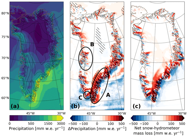
An ensemble of regional climate model simulations is used to estimate the 21st century change in precipitation on the Greenland ice sheet. For the end of the century, the change is in the range 40 to 170 Gt per year, depending on the emission scenario. Using annual values of 2 m air temperature and precipitation, we estimate an increase in precipitation of 35 Gt per year for every degree of warming.
Samuel M. Tax, Maurice van Tiggelen, Thirza N. Feenstra, Paul C. J. P. Smeets, Srinidhi N. Gadde, Christiaan T. van Dalum, Willem Jan van de Berg, and Michiel R. van den Broeke
EGUsphere, https://doi.org/10.5194/egusphere-2026-1926, https://doi.org/10.5194/egusphere-2026-1926, 2026
Short summary
Short summary
Strong winds can lift snow into the air, which influences the energy exchange between the surface and the atmosphere. We studied this phenomenon over the Greenland Ice Sheet using observations and a climate model. We found that blowing snow traps heat near the surface like a blanket and reflects incoming sunlight like a mirror. Simulating these processes increases the net energy at the surface and improves model accuracy. Therefore, we recommend including these effects in climate models.
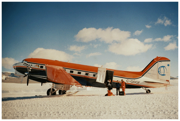
Steven Franke, Daniel Steinhage, Veit Helm, Tobias Binder, Uwe Nixdorf, Heinrich Miller, Angelika Humbert, Daniela Jansen, Graeme Eagles, Hannes Eisermann, Wilfried Jokat, Antonia Ruppel, Reinhard Drews, Alexandra Zuhr, Amelie Driemel, Andreas Walter, Peter Konopatzky, Robin Heß, Antonie Haas, Roland Koppe, Pascal H. Andreas, and Olaf Eisen
The Cryosphere, 20, 2485–2530, https://doi.org/10.5194/tc-20-2485-2026, https://doi.org/10.5194/tc-20-2485-2026, 2026
Short summary
Short summary
This review synthesizes 30 years of Alfred Wegener Institute’s (AWI) airborne radar research in Antarctica and Greenland, detailing six radar systems and their applications in studying ice dynamics, basal properties, and subglacial landscapes. Moreover, it introduces the public release of AWI's airborne radar datasets via the Radar Data over Polar Ice Sheets Viewer and PANGAEA, ensuring findable, accessible, interoperable, and reusable access for future polar research.
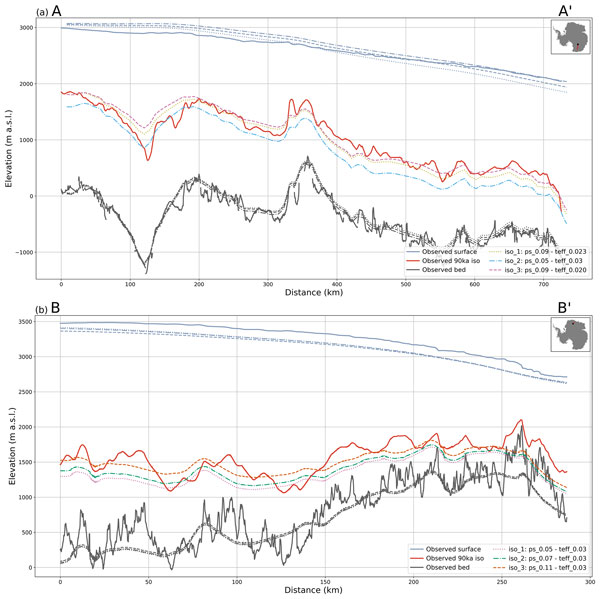
Julien A. Bodart, Vjeran Višnjević, Steven Franke, Veit Helm, Olaf Eisen, Antoine Hermant, Alexandra M. Zuhr, Daniel Steinhage, and Johannes C. R. Sutter
The Cryosphere, 20, 1379–1404, https://doi.org/10.5194/tc-20-1379-2026, https://doi.org/10.5194/tc-20-1379-2026, 2026
Short summary
Short summary
We used radar data and computer models to study layers within Antarctic ice that record past snowfall and ice-sheet changes. These layers, called isochrones, are seldomly used to model Antarctica’s past. By comparing radar observations with simulations, we show how they can greatly improve model accuracy and provide two new datasets to help refine future reconstructions of Antarctic ice evolution.
Benjamin Heurgue, Charles Amory, Christoph Kittel, Fredrik Boberg, Gaël Durand, Vincent Favier, Xavier Fettweis, Quentin Glaude, Heiko Goelzer, Nicolaj Hansen, Nicolas C. Jourdain, Ruth Mottram, Martin Olesen, Willem Jan Van de Berg, Michiel R. Van den Broeke, and René R. Wijngaard
EGUsphere, https://doi.org/10.5194/egusphere-2026-624, https://doi.org/10.5194/egusphere-2026-624, 2026
Short summary
Short summary
We studied how the Antarctic ice sheet surface mass balance may change by 2100 using three high-resolution climate models forced by the same future climate scenario. While the models agree for present-day conditions, they project very different futures, especially over floating ice shelves. These differences mainly come from how melting, refreezing, and temperature are represented. Our results show that future sea level projections strongly depend on how well models simulate today’s climate.
Tesse E. A. van den Aker, Peter Kuipers Munneke, Willem Jan van de Berg, Walter W. Immerzeel, and Michiel R. van den Broeke
EGUsphere, https://doi.org/10.5194/egusphere-2026-462, https://doi.org/10.5194/egusphere-2026-462, 2026
Short summary
Short summary
The firn layer, i.e. permanent snow, regulates how an ice sheet responds to climate change. Firn models are forced with with climate data at time steps from sub-daily to annual in literature, however, implications are barely evaluated. We test the impact of different climate forcing time steps on the modeled firn layer. We conclude that the climate forcing time step (1) affects firn model output, (2) can lead to non-physical behaviour, and (3) that resolving at least a diurnal cycle is required.
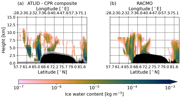
Thirza N. Feenstra, Willem Jan van de Berg, Gerd-Jan van Zadelhoff, David P. Donovan, Christiaan T. van Dalum, and Michiel R. van den Broeke
Atmos. Meas. Tech., 19, 1323–1344, https://doi.org/10.5194/amt-19-1323-2026, https://doi.org/10.5194/amt-19-1323-2026, 2026
Short summary
Short summary
Cloud representation brings large uncertainties in polar climate modeling. We show the first evaluation of Greenland clouds in the Regional Atmospheric Climate Model (RACMO2.4) with new EarthCARE satellite data. Comparing lidar and radar observations and retrieved cloud profiles with co-located RACMO output, we find RACMO captures low ice clouds but underestimates high clouds, mid-altitude liquid clouds, and snowfall. These results highlight EarthCARE's potential to improve polar climate models.
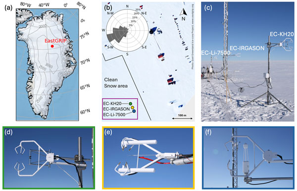
Ida Haven, Hans Christian Steen-Larsen, Laura J. Dietrich, Sonja Wahl, Jason E. Box, Michiel R. van den Broeke, Alun Hubbard, Stephan T. Kral, Joachim Reuder, and Maurice van Tiggelen
The Cryosphere, 20, 573–593, https://doi.org/10.5194/tc-20-573-2026, https://doi.org/10.5194/tc-20-573-2026, 2026
Short summary
Short summary
Three independent Eddy-Covariance measurement systems deployed on top of the Greenland Ice Sheet are compared. Using this dataset, we evaluate the reproducibility and quantify the differences between the systems. The fidelity of two regional climate models in capturing the seasonal variability in the latent and sensible heat flux between the snow surface and the atmosphere is assessed. We identify differences between observations and model simulations, especially during the winter period.

Horst Machguth, Andrew Tedstone, Peter Kuipers Munneke, Max Brils, Brice Noël, Nicole Clerx, Nicolas Jullien, Xavier Fettweis, and Michiel van den Broeke
The Cryosphere, 20, 427–452, https://doi.org/10.5194/tc-20-427-2026, https://doi.org/10.5194/tc-20-427-2026, 2026
Short summary
Short summary
Due to increasing air temperatures, surface melt expands to higher elevations on the Greenland ice sheet. This is visible on satellite imagery in the form of rivers of meltwater running across the surface of the ice sheet. We compare model results of meltwater at high elevations on the ice sheet to satellite observations. We find that each of the models shows strengths and weaknesses. A detailed look into the model results reveals potential reasons for the differences between models.
Valeria Di Biase, Peter Kuipers Munneke, Bert Wouters, Michiel R. van den Broeke, and Maurice van Tiggelen
The Cryosphere, 20, 87–96, https://doi.org/10.5194/tc-20-87-2026, https://doi.org/10.5194/tc-20-87-2026, 2026
Short summary
Short summary
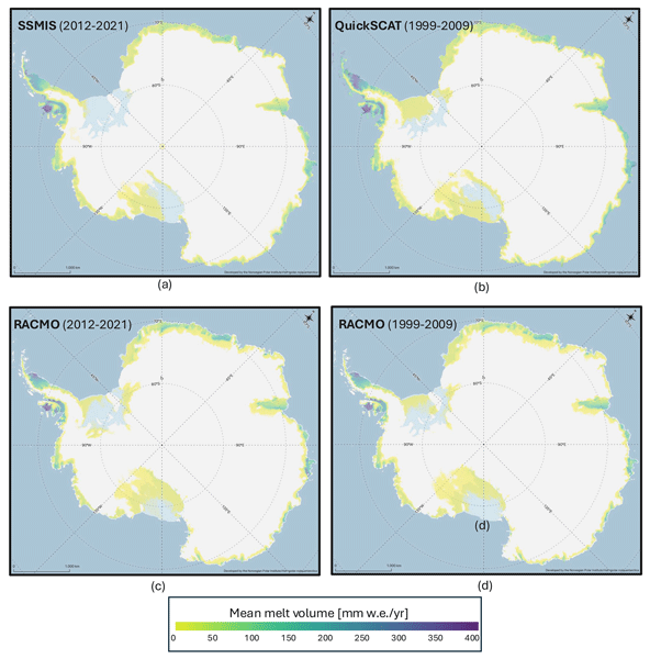
We produce annual maps of Antarctic surface melt volumes from 2012 to 2021 using satellite microwave data. We detect melting days from thresholds on the satellite signal and then use actual melt measurements from weather stations to convert those signals into water‑equivalent volumes. Our maps capture known melt hotspots and show slightly lower totals than climate models. This dataset supports climate and ice‑shelf studies.

Heiko Goelzer, Constantijn J. Berends, Fredrik Boberg, Gael Durand, Tamsin L. Edwards, Xavier Fettweis, Fabien Gillet-Chaulet, Quentin Glaude, Philippe Huybrechts, Sébastien Le clec'h, Ruth Mottram, Brice Noël, Martin Olesen, Charlotte Rahlves, Jeremy Rohmer, Michiel van den Broeke, and Roderik S. W. van de Wal
The Cryosphere, 19, 6887–6906, https://doi.org/10.5194/tc-19-6887-2025, https://doi.org/10.5194/tc-19-6887-2025, 2025
Short summary
Short summary
We present an ensemble of ice sheet model projections for the Greenland ice sheet. The focus is on providing projections that improve our understanding of the range future sea-level rise and the inherent uncertainties over the next 100 to 300 years. Compared to earlier work we more fully account for some of the uncertainties in sea-level projections. We include a wider range of climate model output, more climate change scenarios and we extend projections schematically up to year 2300.
Maria T. Kappelsberger, Johan Nilsson, Martin Horwath, Veit Helm, and Alex S. Gardner
EGUsphere, https://doi.org/10.5194/egusphere-2025-5745, https://doi.org/10.5194/egusphere-2025-5745, 2025
Short summary
Short summary
We compare surface elevation changes of the Antarctic Ice Sheet interior as derived from satellite radar altimetry and laser altimetry between 2019 and 2024. Both methods indicate an increase in surface elevation across most of the study area, coinciding with an episode of excess snow accumulation as modelled. However, rates of surface elevation increase from radar altimetry are systematically lower than those from laser altimetry.
Steven Franke, Mara Neudert, Veit Helm, Arttu Jutila, Océane Hames, Niklas Neckel, Stefanie Arndt, and Christian Haas
The Cryosphere, 19, 6319–6339, https://doi.org/10.5194/tc-19-6319-2025, https://doi.org/10.5194/tc-19-6319-2025, 2025
Short summary
Short summary
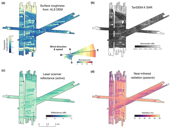
Our research explored how icebergs affect the distribution of snow and flooding on Antarctic coastal sea ice. Using aircraft-based radar and laser scanning, we found that icebergs create thick snow drifts on their wind-facing sides and leave snow-free zones in their lee. The weight of these snow drifts often causes the ice below to flood, forming slush. These patterns, driven by wind and iceberg placement, are crucial for understanding sea ice changes and improving climate models.
Charlotte M. Carter, Steven Franke, Daniela Jansen, Chris R. Stokes, Veit Helm, John Paden, and Olaf Eisen
The Cryosphere, 19, 5299–5315, https://doi.org/10.5194/tc-19-5299-2025, https://doi.org/10.5194/tc-19-5299-2025, 2025
Short summary
Short summary
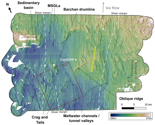
The subglacial landforms beneath actively fast-flowing ice in Greenland have not been explored in detail, as digital elevation models have not had a high enough resolution to see these features. We use swath radar imaging to visualise landforms at the onset of an ice stream, revealing mega-scale glacial lineations, that would usually be assumed to be indicative of faster ice flow than the current velocities. Interpretation of the landscape also gives an indication of the properties of the bed.
Sanne B. M. Veldhuijsen, Willem Jan van de Berg, Peter Kuipers Munneke, Nicolaj Hansen, Fredrik Boberg, Christoph Kittel, Charles Amory, and Michiel R. van den Broeke
The Cryosphere, 19, 5157–5173, https://doi.org/10.5194/tc-19-5157-2025, https://doi.org/10.5194/tc-19-5157-2025, 2025
Short summary
Short summary
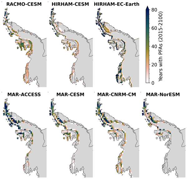
Perennial firn aquifers (PFAs), year-round bodies of liquid water within firns, can potentially impact ice-shelf and ice-sheet stability. We developed a fast XGBoost firn emulator to predict the 21st-century distribution of PFAs in Antarctica for 12 climatic forcing datasets. Our findings suggest that, in low-emission scenarios, PFAs remain confined to the Antarctic Peninsula. However, in a high-emission scenario, PFAs are projected to expand to a region in West Antarctica and East Antarctica.
Christian T. Wild, Reinhard Drews, Niklas Neckel, Joohan Lee, Sihyung Kim, Hyangsun Han, Won Sang Lee, Veit Helm, Sebastian Harry Reid Rosier, Oliver J. Marsh, and Wolfgang Rack
The Cryosphere, 19, 4533–4554, https://doi.org/10.5194/tc-19-4533-2025, https://doi.org/10.5194/tc-19-4533-2025, 2025
Short summary
Short summary
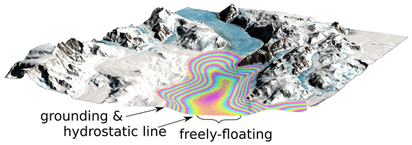
The stability of the Antarctic Ice Sheet depends on how resistance along the sides of large glaciers slows down the flow of ice into the ocean. We present a method to map ice strength using the effect of ocean tides on floating ice shelves. Incorporating weaker ice in shear zones improves the accuracy of model predictions, compared with satellite observations. This demonstrates the untapped potential of radar satellites to map ice stiffness in the most critical areas for ice sheet stability.
Christiaan T. van Dalum, Willem Jan van de Berg, Michiel R. van den Broeke, and Maurice van Tiggelen
The Cryosphere, 19, 4061–4090, https://doi.org/10.5194/tc-19-4061-2025, https://doi.org/10.5194/tc-19-4061-2025, 2025
Short summary
Short summary
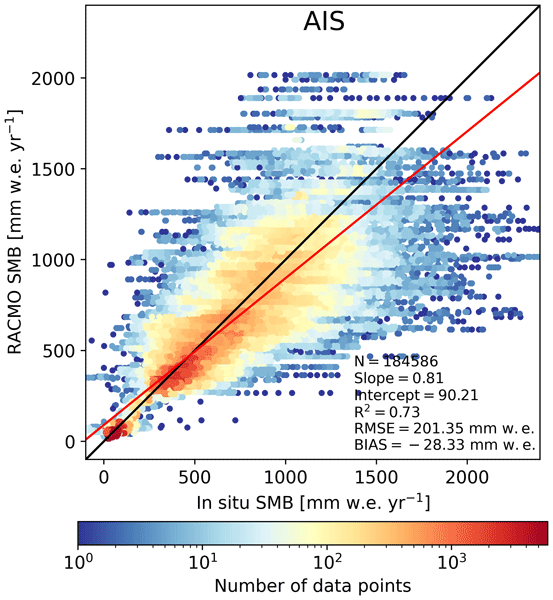
In this study, we present a new surface mass balance (SMB) and near-surface climate product for Antarctica with the regional climate model RACMO2.4p1. We assess the impact of major model updates on the climate of Antarctica. Locally, the SMB has changed substantially but also agrees well with observations. In addition, we show that the SMB components, surface energy budget, albedo, pressure, temperature, and wind speed compare well with in situ and remote sensing observations.
Maurice van Tiggelen, Paul C. J. P. Smeets, Carleen H. Reijmer, Peter Kuipers Munneke, and Michiel R. van den Broeke
Earth Syst. Sci. Data, 17, 4933–4955, https://doi.org/10.5194/essd-17-4933-2025, https://doi.org/10.5194/essd-17-4933-2025, 2025
Short summary
Short summary
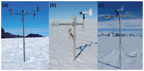
This paper describes the measurements from the 19 IMAU (Institute for Marine and Atmospheric research Utrecht) automatic weather stations that operated on the Antarctic ice sheet from 1995 through 2022. These stations also measured the net surface radiation and surface height change, allowing for the quantification of the surface energy and mass balance at hourly resolution. These data are invaluable for the evaluation of atmospheric models and for the detection of climatological changes.
Anneke L. Vries, Willem Jan van de Berg, Brice Noël, Lorenz Meire, and Michiel R. van den Broeke
The Cryosphere, 19, 3897–3914, https://doi.org/10.5194/tc-19-3897-2025, https://doi.org/10.5194/tc-19-3897-2025, 2025
Short summary
Short summary
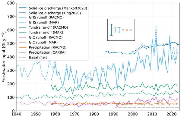
Freshwater flows into Greenland's fjords from various sources. Solid ice discharge (e.g. calving icebergs) dominates freshwater input in the southeast and northwest. In contrast, in the southwest, runoff from the ice sheet and tundra are the most significant. Seasonal data revealed that fjord precipitation and tundra runoff contribute up to 11 % and 35 % of the monthly freshwater input, respectively. Our results provide valuable input for ocean models and for researchers studying fjord ecosystems.
Angelika Humbert, Veit Helm, Ole Zeising, Niklas Neckel, Matthias H. Braun, Shfaqat Abbas Khan, Martin Rückamp, Holger Steeb, Julia Sohn, Matthias Bohnen, and Ralf Müller
The Cryosphere, 19, 3009–3032, https://doi.org/10.5194/tc-19-3009-2025, https://doi.org/10.5194/tc-19-3009-2025, 2025
Short summary
Short summary
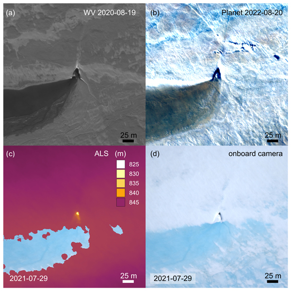
We study the evolution of a massive lake on the Greenland Ice Sheet using satellite and airborne data and some modelling. The lake is emptying rapidly. Water flows to the glacier's base through cracks and triangular-shaped moulins that remain visible over the years. Some of them become reactivated. We find features inside the glacier that stem from drainage events with a width of even 1 km. These features are persistent over the years, although they are changing in shape.
Shfaqat A. Khan, Helene Seroussi, Mathieu Morlighem, William Colgan, Veit Helm, Gong Cheng, Danjal Berg, Valentina R. Barletta, Nicolaj K. Larsen, William Kochtitzky, Michiel van den Broeke, Kurt H. Kjær, Andy Aschwanden, Brice Noël, Jason E. Box, Joseph A. MacGregor, Robert S. Fausto, Kenneth D. Mankoff, Ian M. Howat, Kuba Oniszk, Dominik Fahrner, Anja Løkkegaard, Eigil Y. H. Lippert, Alicia Bråtner, and Javed Hassan
Earth Syst. Sci. Data, 17, 3047–3071, https://doi.org/10.5194/essd-17-3047-2025, https://doi.org/10.5194/essd-17-3047-2025, 2025
Short summary
Short summary
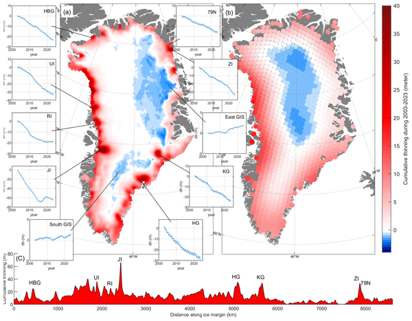
The surface elevation of the Greenland Ice Sheet is changing due to surface mass balance processes and ice dynamics, each exhibiting distinct spatiotemporal patterns. Here, we employ satellite and airborne altimetry data with fine spatial (1 km) and temporal (monthly) resolutions to document this spatiotemporal evolution from 2003 to 2023. This dataset of fine-resolution altimetry data in both space and time will support studies of ice mass loss and be useful for GIS ice sheet modeling.
Matthias O. Willen, Bert Wouters, Taco Broerse, Eric Buchta, and Veit Helm
The Cryosphere, 19, 2213–2227, https://doi.org/10.5194/tc-19-2213-2025, https://doi.org/10.5194/tc-19-2213-2025, 2025
Short summary
Short summary
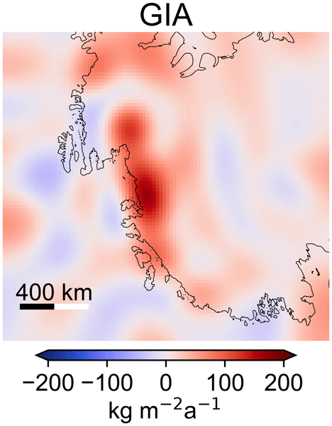
Collapse of the West Antarctic Ice Sheet in the Amundsen Sea Embayment is likely in the near future. Vertical uplift of bedrock due to glacial isostatic adjustment stabilizes the ice sheet and may delay its collapse. So far, only spatially and temporally sparse GPS measurements have been able to observe this bedrock motion. We have combined satellite data and quantified a region-wide bedrock motion that independently matches GPS measurements. This can improve ice sheet predictions.
Torsten Kanzow, Angelika Humbert, Thomas Mölg, Mirko Scheinert, Matthias Braun, Hans Burchard, Francesca Doglioni, Philipp Hochreuther, Martin Horwath, Oliver Huhn, Maria Kappelsberger, Jürgen Kusche, Erik Loebel, Katrina Lutz, Ben Marzeion, Rebecca McPherson, Mahdi Mohammadi-Aragh, Marco Möller, Carolyne Pickler, Markus Reinert, Monika Rhein, Martin Rückamp, Janin Schaffer, Muhammad Shafeeque, Sophie Stolzenberger, Ralph Timmermann, Jenny Turton, Claudia Wekerle, and Ole Zeising
The Cryosphere, 19, 1789–1824, https://doi.org/10.5194/tc-19-1789-2025, https://doi.org/10.5194/tc-19-1789-2025, 2025
Short summary
Short summary
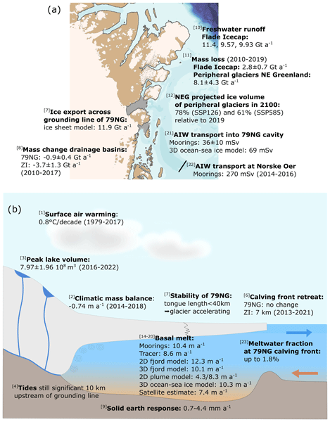
The Greenland Ice Sheet represents the second-largest contributor to global sea-level rise. We quantify atmosphere, ice and ocean processes related to the mass balance of glaciers in northeast Greenland, focusing on Greenland’s largest floating ice tongue, the 79° N Glacier. We find that together, the different in situ and remote sensing observations and model simulations reveal a consistent picture of a coupled atmosphere–ice sheet–ocean system that has entered a phase of major change.
Steven Franke, Daniel Steinhage, Veit Helm, Alexandra M. Zuhr, Julien A. Bodart, Olaf Eisen, and Paul Bons
The Cryosphere, 19, 1153–1180, https://doi.org/10.5194/tc-19-1153-2025, https://doi.org/10.5194/tc-19-1153-2025, 2025
Short summary
Short summary
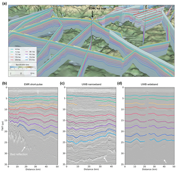
The study presents internal reflection horizons (IRHs) over an area of 450 000 km² from western Dronning Maud Land, Antarctica, spanning 4.8–91 ka. Using radar and ice core data, nine IRHs were dated and correlated with volcanic events. The data enhance our understanding of the ice sheet's age–depth architecture, accumulation, and dynamics. The findings inform ice flow models and contribute to Antarctic-wide comparisons of IRHs, supporting efforts toward a 3D age–depth ice sheet model.
Christoph Dahle, Eva Boergens, Ingo Sasgen, Thorben Döhne, Sven Reißland, Henryk Dobslaw, Volker Klemann, Michael Murböck, Rolf König, Robert Dill, Mike Sips, Ulrike Sylla, Andreas Groh, Martin Horwath, and Frank Flechtner
Earth Syst. Sci. Data, 17, 611–631, https://doi.org/10.5194/essd-17-611-2025, https://doi.org/10.5194/essd-17-611-2025, 2025
Short summary
Short summary
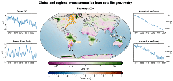
GRACE and GRACE-FO are unique observing systems to quantify mass changes at the Earth’s surface from space. Time series of these mass changes are of high value for various applications, e.g., in hydrology, glaciology, and oceanography. GravIS (Gravity Information Service) provides easy access to user-friendly, regularly updated mass anomaly products. The portal visualizes and describes these data, aiming to highlight their significance for understanding changes in the climate system.
Erik Loebel, Celia A. Baumhoer, Andreas Dietz, Mirko Scheinert, and Martin Horwath
Earth Syst. Sci. Data, 17, 65–78, https://doi.org/10.5194/essd-17-65-2025, https://doi.org/10.5194/essd-17-65-2025, 2025
Short summary
Short summary
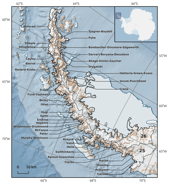
Glacier calving front positions are important for understanding glacier dynamics and constraining ice modelling. We apply a deep-learning framework to multi-spectral Landsat imagery to create a calving front record for 42 key outlet glaciers of the Antarctic Peninsula Ice Sheet. The resulting data product includes 4817 calving front locations from 2013 to 2023 and achieves sub-seasonal temporal resolution.
Abelardo Romero, Andreas Richter, Amilcar Juarez, Federico Suad Corbetta, Eric Marderwald, Pedro Granovsky, Thorben Döhne, and Martin Horwath
Int. Arch. Photogramm. Remote Sens. Spatial Inf. Sci., XLVIII-2-W6-2024, 51–58, https://doi.org/10.5194/isprs-archives-XLVIII-2-W6-2024-51-2024, https://doi.org/10.5194/isprs-archives-XLVIII-2-W6-2024-51-2024, 2024
Maria T. Kappelsberger, Martin Horwath, Eric Buchta, Matthias O. Willen, Ludwig Schröder, Sanne B. M. Veldhuijsen, Peter Kuipers Munneke, and Michiel R. van den Broeke
The Cryosphere, 18, 4355–4378, https://doi.org/10.5194/tc-18-4355-2024, https://doi.org/10.5194/tc-18-4355-2024, 2024
Short summary
Short summary
The interannual variations in the height of the Antarctic Ice Sheet (AIS) are mainly due to natural variations in snowfall. Precise knowledge of these variations is important for the detection of any long-term climatic trends in AIS surface elevation. We present a new product that spatially resolves these height variations over the period 1992–2017. The product combines the strengths of atmospheric modeling results and satellite altimetry measurements.
Christiaan T. van Dalum, Willem Jan van de Berg, Srinidhi N. Gadde, Maurice van Tiggelen, Tijmen van der Drift, Erik van Meijgaard, Lambertus H. van Ulft, and Michiel R. van den Broeke
The Cryosphere, 18, 4065–4088, https://doi.org/10.5194/tc-18-4065-2024, https://doi.org/10.5194/tc-18-4065-2024, 2024
Short summary
Short summary
We present a new version of the polar Regional Atmospheric Climate Model (RACMO), version 2.4p1, and show first results for Greenland, Antarctica and the Arctic. We provide an overview of all changes and investigate the impact that they have on the climate of polar regions. By comparing the results with observations and the output from the previous model version, we show that the model performs well regarding the surface mass balance of the ice sheets and near-surface climate.
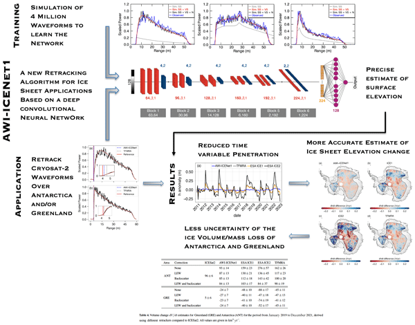
Veit Helm, Alireza Dehghanpour, Ronny Hänsch, Erik Loebel, Martin Horwath, and Angelika Humbert
The Cryosphere, 18, 3933–3970, https://doi.org/10.5194/tc-18-3933-2024, https://doi.org/10.5194/tc-18-3933-2024, 2024
Short summary
Short summary
We present a new approach (AWI-ICENet1), based on a deep convolutional neural network, for analysing satellite radar altimeter measurements to accurately determine the surface height of ice sheets. Surface height estimates obtained with AWI-ICENet1 (along with related products, such as ice sheet height change and volume change) show improved and unbiased results compared to other products. This is important for the long-term monitoring of ice sheet mass loss and its impact on sea level rise.
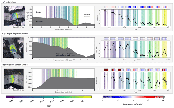
Erik Loebel, Mirko Scheinert, Martin Horwath, Angelika Humbert, Julia Sohn, Konrad Heidler, Charlotte Liebezeit, and Xiao Xiang Zhu
The Cryosphere, 18, 3315–3332, https://doi.org/10.5194/tc-18-3315-2024, https://doi.org/10.5194/tc-18-3315-2024, 2024
Short summary
Short summary
Comprehensive datasets of calving-front changes are essential for studying and modeling outlet glaciers. Current records are limited in temporal resolution due to manual delineation. We use deep learning to automatically delineate calving fronts for 23 glaciers in Greenland. Resulting time series resolve long-term, seasonal, and subseasonal patterns. We discuss the implications of our results and provide the cryosphere community with a data product and an implementation of our processing system.
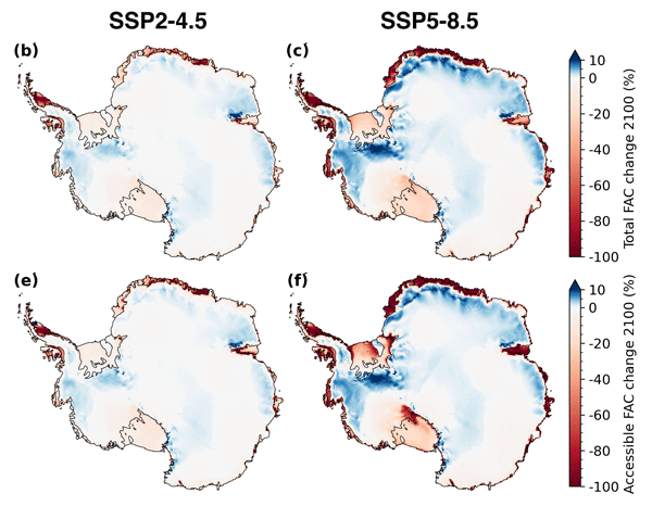
Sanne B. M. Veldhuijsen, Willem Jan van de Berg, Peter Kuipers Munneke, and Michiel R. van den Broeke
The Cryosphere, 18, 1983–1999, https://doi.org/10.5194/tc-18-1983-2024, https://doi.org/10.5194/tc-18-1983-2024, 2024
Short summary
Short summary
We use the IMAU firn densification model to simulate the 21st-century evolution of Antarctic firn air content. Ice shelves on the Antarctic Peninsula and the Roi Baudouin Ice Shelf in Dronning Maud Land are particularly vulnerable to total firn air content (FAC) depletion. Our results also underline the potentially large vulnerability of low-accumulation ice shelves to firn air depletion through ice slab formation.
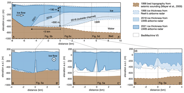
Ole Zeising, Niklas Neckel, Nils Dörr, Veit Helm, Daniel Steinhage, Ralph Timmermann, and Angelika Humbert
The Cryosphere, 18, 1333–1357, https://doi.org/10.5194/tc-18-1333-2024, https://doi.org/10.5194/tc-18-1333-2024, 2024
Short summary
Short summary
The 79° North Glacier in Greenland has experienced significant changes over the last decades. Due to extreme melt rates, the ice has thinned significantly in the vicinity of the grounding line, where a large subglacial channel has formed since 2010. We attribute these changes to warm ocean currents and increased subglacial discharge from surface melt. However, basal melting has decreased since 2018, indicating colder water inflow into the cavity below the glacier.
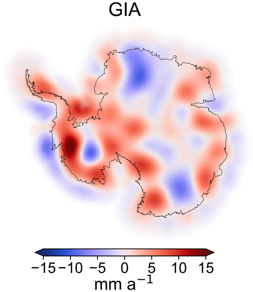
Matthias O. Willen, Martin Horwath, Eric Buchta, Mirko Scheinert, Veit Helm, Bernd Uebbing, and Jürgen Kusche
The Cryosphere, 18, 775–790, https://doi.org/10.5194/tc-18-775-2024, https://doi.org/10.5194/tc-18-775-2024, 2024
Short summary
Short summary
Shrinkage of the Antarctic ice sheet (AIS) leads to sea level rise. Satellite gravimetry measures AIS mass changes. We apply a new method that overcomes two limitations: low spatial resolution and large uncertainties due to the Earth's interior mass changes. To do so, we additionally include data from satellite altimetry and climate and firn modelling, which are evaluated in a globally consistent way with thoroughly characterized errors. The results are in better agreement with independent data.
Reinhard Dietrich, Christoph Knöfel, Mirko Scheinert, and Ralf Rosenau
Polarforschung, 92, 1–13, https://doi.org/10.5194/polf-92-1-2024, https://doi.org/10.5194/polf-92-1-2024, 2024
Short summary
Short summary
Drygalski führte in den Jahren 1891 und 1892/93 Forschungsarbeiten in Westgrönland durch, wobei zur Überwinterung eine Forschungsstation am Großen Karajak-Gletscher errichtetet wurde. An gleicher Stelle erfolgten durch die TU Dresden 2007 und 2019 geodätische Feldarbeiten. Im Beitrag werden das Areal der damaligen Station sowie die Forschungsarbeiten Drygalskis vorgestellt. Ein Vergleich mit heutigen Messungen zeigt, dass sich der Große Karajak-Gletscher in 120 Jahren kaum verändert hat.
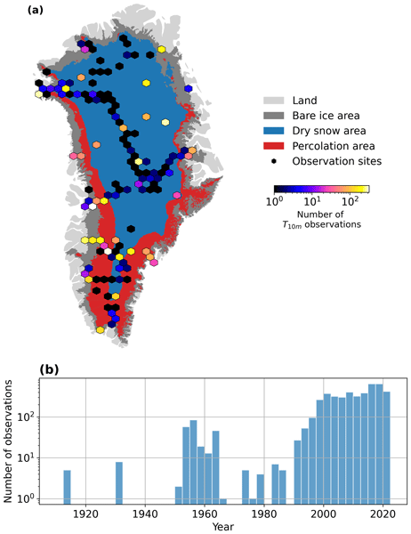
Baptiste Vandecrux, Robert S. Fausto, Jason E. Box, Federico Covi, Regine Hock, Åsa K. Rennermalm, Achim Heilig, Jakob Abermann, Dirk van As, Elisa Bjerre, Xavier Fettweis, Paul C. J. P. Smeets, Peter Kuipers Munneke, Michiel R. van den Broeke, Max Brils, Peter L. Langen, Ruth Mottram, and Andreas P. Ahlstrøm
The Cryosphere, 18, 609–631, https://doi.org/10.5194/tc-18-609-2024, https://doi.org/10.5194/tc-18-609-2024, 2024
Short summary
Short summary
How fast is the Greenland ice sheet warming? In this study, we compiled 4500+ temperature measurements at 10 m below the ice sheet surface (T10m) from 1912 to 2022. We trained a machine learning model on these data and reconstructed T10m for the ice sheet during 1950–2022. After a slight cooling during 1950–1985, the ice sheet warmed at a rate of 0.7 °C per decade until 2022. Climate models showed mixed results compared to our observations and underestimated the warming in key regions.
Lena G. Buth, Valeria Di Biase, Peter Kuipers Munneke, Stef Lhermitte, Sanne B. M. Veldhuijsen, Sophie de Roda Husman, Michiel R. van den Broeke, and Bert Wouters
EGUsphere, https://doi.org/10.5194/egusphere-2023-2000, https://doi.org/10.5194/egusphere-2023-2000, 2023
Preprint archived
Short summary
Short summary
Liquid meltwater which is stored in air bubbles in the compacted snow near the surface of Antarctica can affect ice shelf stability. In order to detect the presence of such firn aquifers over large scales, satellite remote sensing is needed. In this paper, we present our new detection method using radar satellite data as well as the results for the whole Antarctic Peninsula. Firn aquifers are found in the north and northwest of the peninsula, in agreement with locations predicted by models.
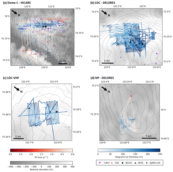
Ailsa Chung, Frédéric Parrenin, Daniel Steinhage, Robert Mulvaney, Carlos Martín, Marie G. P. Cavitte, David A. Lilien, Veit Helm, Drew Taylor, Prasad Gogineni, Catherine Ritz, Massimo Frezzotti, Charles O'Neill, Heinrich Miller, Dorthe Dahl-Jensen, and Olaf Eisen
The Cryosphere, 17, 3461–3483, https://doi.org/10.5194/tc-17-3461-2023, https://doi.org/10.5194/tc-17-3461-2023, 2023
Short summary
Short summary
We combined a numerical model with radar measurements in order to determine the age of ice in the Dome C region of Antarctica. Our results show that at the current ice core drilling sites on Little Dome C, the maximum age of the ice is almost 1.5 Ma. We also highlight a new potential drill site called North Patch with ice up to 2 Ma. Finally, we explore the nature of a stagnant ice layer at the base of the ice sheet which has been independently observed and modelled but is not well understood.
Angelika Humbert, Veit Helm, Niklas Neckel, Ole Zeising, Martin Rückamp, Shfaqat Abbas Khan, Erik Loebel, Jörg Brauchle, Karsten Stebner, Dietmar Gross, Rabea Sondershaus, and Ralf Müller
The Cryosphere, 17, 2851–2870, https://doi.org/10.5194/tc-17-2851-2023, https://doi.org/10.5194/tc-17-2851-2023, 2023
Short summary
Short summary
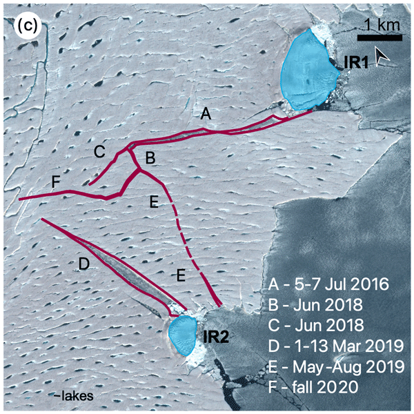
The largest floating glacier mass in Greenland, the 79° N Glacier, is showing signs of instability. We investigate how crack formation at the glacier's calving front has changed over the last decades by using satellite imagery and airborne data. The calving front is about to lose contact to stabilizing ice islands. Simulations show that the glacier will accelerate as a result of this, leading to an increase in ice discharge of more than 5.1 % if its calving front retreats by 46 %.
Michael J. Bentley, James A. Smith, Stewart S. R. Jamieson, Margaret R. Lindeman, Brice R. Rea, Angelika Humbert, Timothy P. Lane, Christopher M. Darvill, Jeremy M. Lloyd, Fiamma Straneo, Veit Helm, and David H. Roberts
The Cryosphere, 17, 1821–1837, https://doi.org/10.5194/tc-17-1821-2023, https://doi.org/10.5194/tc-17-1821-2023, 2023
Short summary
Short summary
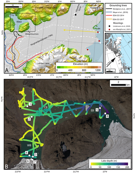
The Northeast Greenland Ice Stream is a major outlet of the Greenland Ice Sheet. Some of its outlet glaciers and ice shelves have been breaking up and retreating, with inflows of warm ocean water identified as the likely reason. Here we report direct measurements of warm ocean water in an unusual lake that is connected to the ocean beneath the ice shelf in front of the 79° N Glacier. This glacier has not yet shown much retreat, but the presence of warm water makes future retreat more likely.
Inès N. Otosaka, Andrew Shepherd, Erik R. Ivins, Nicole-Jeanne Schlegel, Charles Amory, Michiel R. van den Broeke, Martin Horwath, Ian Joughin, Michalea D. King, Gerhard Krinner, Sophie Nowicki, Anthony J. Payne, Eric Rignot, Ted Scambos, Karen M. Simon, Benjamin E. Smith, Louise S. Sørensen, Isabella Velicogna, Pippa L. Whitehouse, Geruo A, Cécile Agosta, Andreas P. Ahlstrøm, Alejandro Blazquez, William Colgan, Marcus E. Engdahl, Xavier Fettweis, Rene Forsberg, Hubert Gallée, Alex Gardner, Lin Gilbert, Noel Gourmelen, Andreas Groh, Brian C. Gunter, Christopher Harig, Veit Helm, Shfaqat Abbas Khan, Christoph Kittel, Hannes Konrad, Peter L. Langen, Benoit S. Lecavalier, Chia-Chun Liang, Bryant D. Loomis, Malcolm McMillan, Daniele Melini, Sebastian H. Mernild, Ruth Mottram, Jeremie Mouginot, Johan Nilsson, Brice Noël, Mark E. Pattle, William R. Peltier, Nadege Pie, Mònica Roca, Ingo Sasgen, Himanshu V. Save, Ki-Weon Seo, Bernd Scheuchl, Ernst J. O. Schrama, Ludwig Schröder, Sebastian B. Simonsen, Thomas Slater, Giorgio Spada, Tyler C. Sutterley, Bramha Dutt Vishwakarma, Jan Melchior van Wessem, David Wiese, Wouter van der Wal, and Bert Wouters
Earth Syst. Sci. Data, 15, 1597–1616, https://doi.org/10.5194/essd-15-1597-2023, https://doi.org/10.5194/essd-15-1597-2023, 2023
Short summary
Short summary
By measuring changes in the volume, gravitational attraction, and ice flow of Greenland and Antarctica from space, we can monitor their mass gain and loss over time. Here, we present a new record of the Earth’s polar ice sheet mass balance produced by aggregating 50 satellite-based estimates of ice sheet mass change. This new assessment shows that the ice sheets have lost (7.5 x 10¹²) t of ice between 1992 and 2020, contributing 21 mm to sea level rise.

Sanne B. M. Veldhuijsen, Willem Jan van de Berg, Max Brils, Peter Kuipers Munneke, and Michiel R. van den Broeke
The Cryosphere, 17, 1675–1696, https://doi.org/10.5194/tc-17-1675-2023, https://doi.org/10.5194/tc-17-1675-2023, 2023
Short summary
Short summary
Firn is the transition of snow to glacier ice and covers 99 % of the Antarctic ice sheet. Knowledge about the firn layer and its variability is important, as it impacts satellite-based estimates of ice sheet mass change. Also, firn contains pores in which nearly all of the surface melt is retained. Here, we improve a semi-empirical firn model and simulate the firn characteristics for the period 1979–2020. We evaluate the performance with field and satellite measures and test its sensitivity.
Marte G. Hofsteenge, Nicolas J. Cullen, Carleen H. Reijmer, Michiel van den Broeke, Marwan Katurji, and John F. Orwin
The Cryosphere, 16, 5041–5059, https://doi.org/10.5194/tc-16-5041-2022, https://doi.org/10.5194/tc-16-5041-2022, 2022
Short summary
Short summary
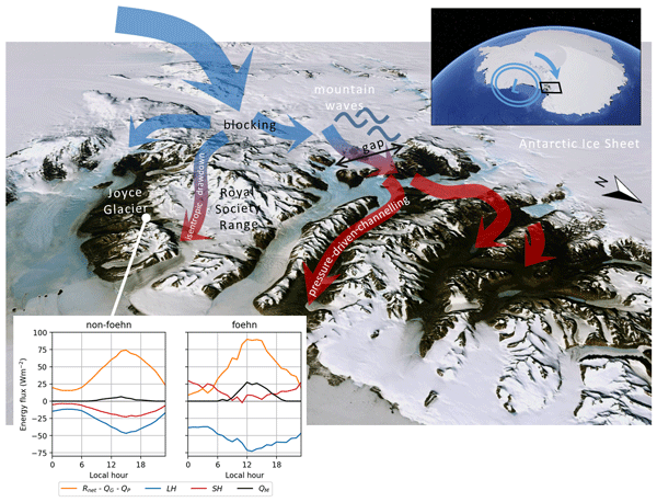
In the McMurdo Dry Valleys (MDV), foehn winds can impact glacial meltwater production and the fragile ecosystem that depends on it. We study these dry and warm winds at Joyce Glacier and show they are caused by a different mechanism than that found for nearby valleys, demonstrating the complex interaction of large-scale winds with the mountains in the MDV. We find that foehn winds increase sublimation of ice, increase heating from the atmosphere, and increase the occurrence and rates of melt.
Angelika Humbert, Julia Christmann, Hugh F. J. Corr, Veit Helm, Lea-Sophie Höyns, Coen Hofstede, Ralf Müller, Niklas Neckel, Keith W. Nicholls, Timm Schultz, Daniel Steinhage, Michael Wolovick, and Ole Zeising
The Cryosphere, 16, 4107–4139, https://doi.org/10.5194/tc-16-4107-2022, https://doi.org/10.5194/tc-16-4107-2022, 2022
Short summary
Short summary
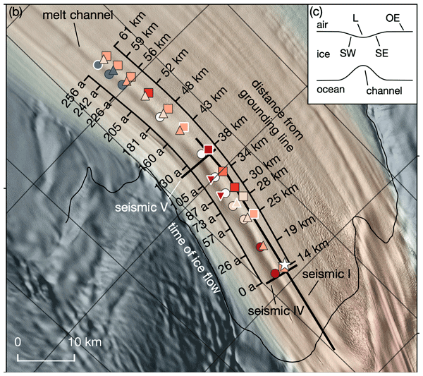
Ice shelves are normally flat structures that fringe the Antarctic continent. At some locations they have channels incised into their underside. On Filchner Ice Shelf, such a channel is more than 50 km long and up to 330 m high. We conducted field measurements of basal melt rates and found a maximum of 2 m yr−1. Simulations represent the geometry evolution of the channel reasonably well. There is no reason to assume that this type of melt channel is destabilizing ice shelves.
Lena G. Buth, Bert Wouters, Sanne B. M. Veldhuijsen, Stef Lhermitte, Peter Kuipers Munneke, and Michiel R. van den Broeke
The Cryosphere Discuss., https://doi.org/10.5194/tc-2022-127, https://doi.org/10.5194/tc-2022-127, 2022
Manuscript not accepted for further review
Short summary
Short summary
Liquid meltwater which is stored in air bubbles in the compacted snow near the surface of Antarctica can affect ice shelf stability. In order to detect the presence of such firn aquifers over large scales, satellite remote sensing is needed. In this paper, we present our new detection method using radar satellite data as well as the results for the whole Antarctic Peninsula. Firn aquifers are found in the north and northwest of the peninsula, in agreement with locations predicted by models.
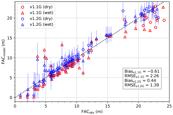
Max Brils, Peter Kuipers Munneke, Willem Jan van de Berg, and Michiel van den Broeke
Geosci. Model Dev., 15, 7121–7138, https://doi.org/10.5194/gmd-15-7121-2022, https://doi.org/10.5194/gmd-15-7121-2022, 2022
Short summary
Short summary
Firn covers the Greenland ice sheet (GrIS) and can temporarily prevent mass loss. Here, we present the latest version of our firn model, IMAU-FDM, with an application to the GrIS. We improved the density of fallen snow, the firn densification rate and the firn's thermal conductivity. This leads to a higher air content and 10 m temperatures. Furthermore we investigate three case studies and find that the updated model shows greater variability and an increased sensitivity in surface elevation.
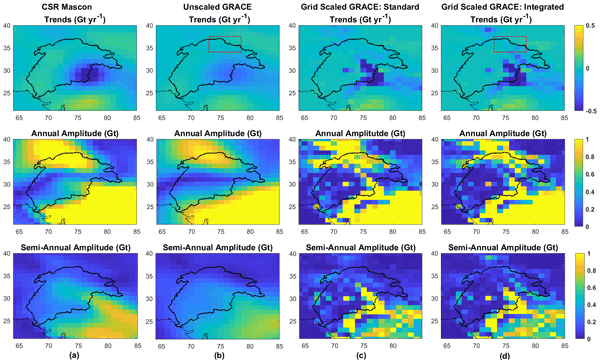
Vasaw Tripathi, Andreas Groh, Martin Horwath, and Raaj Ramsankaran
Hydrol. Earth Syst. Sci., 26, 4515–4535, https://doi.org/10.5194/hess-26-4515-2022, https://doi.org/10.5194/hess-26-4515-2022, 2022
Short summary
Short summary
GRACE/GRACE-FO provided global observations of water storage change since 2002. Scaling is a common approach to compensate for the spatial filtering inherent to the results. However, for complex hydrological basins, the compatibility of scaling with the characteristics of regional hydrology has been rarely assessed. We assess traditional scaling approaches and a new scaling approach for the Indus Basin. Our results will help users with regional focus understand implications of scaling choices.
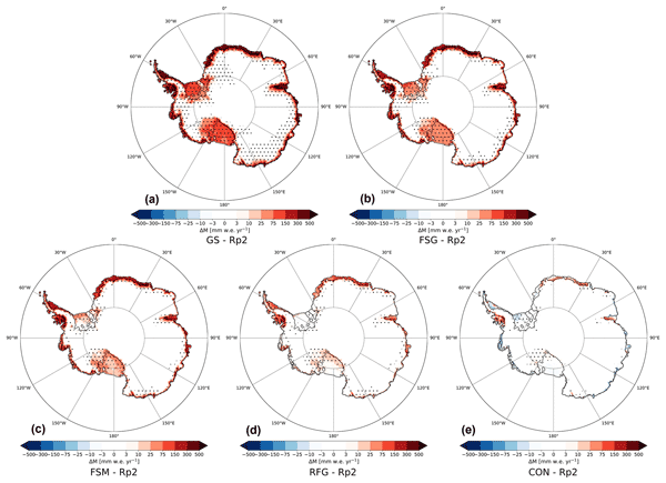
Christiaan T. van Dalum, Willem Jan van de Berg, and Michiel R. van den Broeke
The Cryosphere, 16, 1071–1089, https://doi.org/10.5194/tc-16-1071-2022, https://doi.org/10.5194/tc-16-1071-2022, 2022
Short summary
Short summary
In this study, we improve the regional climate model RACMO2 and investigate the climate of Antarctica. We have implemented a new radiative transfer and snow albedo scheme and do several sensitivity experiments. When fully tuned, the results compare well with observations and snow temperature profiles improve. Moreover, small changes in the albedo and the investigated processes can lead to a strong overestimation of melt, locally leading to runoff and a reduced surface mass balance.
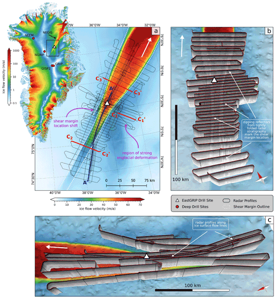
Steven Franke, Daniela Jansen, Tobias Binder, John D. Paden, Nils Dörr, Tamara A. Gerber, Heinrich Miller, Dorthe Dahl-Jensen, Veit Helm, Daniel Steinhage, Ilka Weikusat, Frank Wilhelms, and Olaf Eisen
Earth Syst. Sci. Data, 14, 763–779, https://doi.org/10.5194/essd-14-763-2022, https://doi.org/10.5194/essd-14-763-2022, 2022
Short summary
Short summary
The Northeast Greenland Ice Stream (NEGIS) is the largest ice stream in Greenland. In order to better understand the past and future dynamics of the NEGIS, we present a high-resolution airborne radar data set (EGRIP-NOR-2018) for the onset region of the NEGIS. The survey area is centered at the location of the drill site of the East Greenland Ice-Core Project (EastGRIP), and radar profiles cover both shear margins and are aligned parallel to several flow lines.
Martin Horwath, Benjamin D. Gutknecht, Anny Cazenave, Hindumathi Kulaiappan Palanisamy, Florence Marti, Ben Marzeion, Frank Paul, Raymond Le Bris, Anna E. Hogg, Inès Otosaka, Andrew Shepherd, Petra Döll, Denise Cáceres, Hannes Müller Schmied, Johnny A. Johannessen, Jan Even Øie Nilsen, Roshin P. Raj, René Forsberg, Louise Sandberg Sørensen, Valentina R. Barletta, Sebastian B. Simonsen, Per Knudsen, Ole Baltazar Andersen, Heidi Ranndal, Stine K. Rose, Christopher J. Merchant, Claire R. Macintosh, Karina von Schuckmann, Kristin Novotny, Andreas Groh, Marco Restano, and Jérôme Benveniste
Earth Syst. Sci. Data, 14, 411–447, https://doi.org/10.5194/essd-14-411-2022, https://doi.org/10.5194/essd-14-411-2022, 2022
Short summary
Short summary
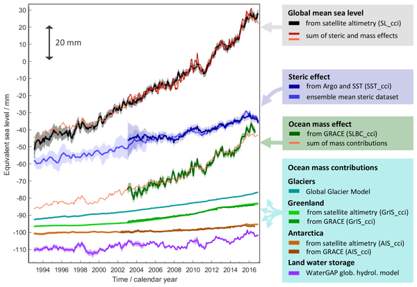
Global mean sea-level change observed from 1993 to 2016 (mean rate of 3.05 mm yr−1) matches the combined effect of changes in water density (thermal expansion) and ocean mass. Ocean-mass change has been assessed through the contributions from glaciers, ice sheets, and land water storage or directly from satellite data since 2003. Our budget assessments of linear trends and monthly anomalies utilise new datasets and uncertainty characterisations developed within ESA's Climate Change Initiative.
Zhongyang Hu, Peter Kuipers Munneke, Stef Lhermitte, Maaike Izeboud, and Michiel van den Broeke
The Cryosphere, 15, 5639–5658, https://doi.org/10.5194/tc-15-5639-2021, https://doi.org/10.5194/tc-15-5639-2021, 2021
Short summary
Short summary
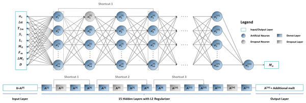
Antarctica is shrinking, and part of the mass loss is caused by higher temperatures leading to more snowmelt. We use computer models to estimate the amount of melt, but this can be inaccurate – specifically in the areas with the most melt. This is because the model cannot account for small, darker areas like rocks or darker ice. Thus, we trained a computer using artificial intelligence and satellite images that showed these darker areas. The model computed an improved estimate of melt.
Kenneth D. Mankoff, Xavier Fettweis, Peter L. Langen, Martin Stendel, Kristian K. Kjeldsen, Nanna B. Karlsson, Brice Noël, Michiel R. van den Broeke, Anne Solgaard, William Colgan, Jason E. Box, Sebastian B. Simonsen, Michalea D. King, Andreas P. Ahlstrøm, Signe Bech Andersen, and Robert S. Fausto
Earth Syst. Sci. Data, 13, 5001–5025, https://doi.org/10.5194/essd-13-5001-2021, https://doi.org/10.5194/essd-13-5001-2021, 2021
Short summary
Short summary
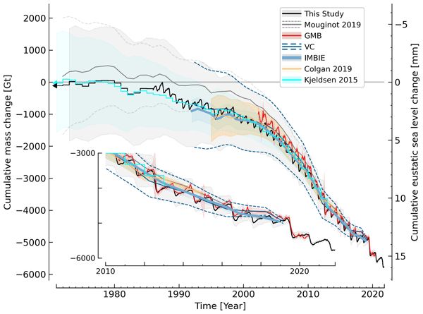
We estimate the daily mass balance and its components (surface, marine, and basal mass balance) for the Greenland ice sheet. Our time series begins in 1840 and has annual resolution through 1985 and then daily from 1986 through next week. Results are operational (updated daily) and provided for the entire ice sheet or by commonly used regions or sectors. This is the first input–output mass balance estimate to include the basal mass balance.
Cited articles
Adusumilli, S., Fricker, H. A., Siegfried, M. R., Padman, L., Paolo, F. S., and
Ligtenberg, S. R. M.: Variable Basal Melt Rates of Antarctic Peninsula Ice
Shelves, 1994–2016, Geophys. Res. Lett., 45, 4086–4095,
https://doi.org/10.1002/2017gl076652, 2018. a
Arthern, R., Wingham, D., and Ridout, A.: Controls on ERS altimeter
measurements over ice sheets: Footprint-scale topography, backscatter
fluctuations, and the dependence of microwave penetration depth on satellite
orientation, J. Geophys. Res.-Atmos., 106,
33471–33484, https://doi.org/10.1029/2001JD000498, 2001. a, b
Baarda, W.: A testing procedure for use in geodetic networks, Netherlands
Geodetic Commission, Delft, the Netherlands, 1968. a
Bamber, J. L., Gomez-Dans, J. L., and Griggs, J. A.: A new 1 km digital
elevation model of the Antarctic derived from combined satellite radar and
laser data – Part 1: Data and methods, The Cryosphere, 3, 101–111,
https://doi.org/10.5194/tc-3-101-2009, 2009. a
Boening, C., Lebsock, M., Landerer, F., and Stephens, G.: Snowfall-driven mass
change on the East Antarctic ice sheet, Geophys. Res. Lett., 39, L21501,
https://doi.org/10.1029/2012GL053316, 2012. a, b
Brenner, A., Bindschadler, R., Zwally, H., and Thomas, R.: Slope-induced
errors in radar altimetry over continental ice sheets, J. Geophys. Res., 88,
1617–1623, https://doi.org/10.1029/JC088iC03p01617, 1983. a
Brenner, A., DiMarzio, J., and Zwally, H.: Precision and Accuracy of Satellite
Radar and Laser Altimeter Data Over the Continental Ice Sheets, IEEE T.
Geosci. Remote, 45, 321–331, https://doi.org/10.1109/TGRS.2006.887172, 2007. a
Brockley, D., Baker, S., Femenias, P., Martinez, B., Massmann, F.-H., Otten,
M., Paul, F., Picard, B., Prandi, P., Roca, M., Rudenko, S., Scharroo, R.,
and Visser, P.: REAPER: Reprocessing 12 Years of ERS-1 and ERS-2 Altimeters
and Microwave Radiometer Data, IEEE T. Geosci. Remote, 55,
5506–5514, https://doi.org/10.1109/TGRS.2017.2709343, 2017. a, b
Brunt, K. M., Hawley, R. L., Lutz, E. R., Studinger, M., Sonntag, J. G.,
Hofton, M. A., Andrews, L. C., and Neumann, T. A.: Assessment of NASA
airborne laser altimetry data using ground-based GPS data near Summit
Station, Greenland, The Cryosphere, 11, 681–692,
https://doi.org/10.5194/tc-11-681-2017, 2017. a
Brunt, K. M., Neumann, T. A., and Larsen, C. F.: Assessment of altimetry
using ground-based GPS data from the 88S Traverse, Antarctica, in support of
ICESat-2, The Cryosphere Discuss., https://doi.org/10.5194/tc-2018-160, in
review, 2018. a
Chuter, S., Martín-Español, A., Wouters, B., and Bamber, J.: Mass
balance reassessment of glaciers draining into the Abbot and Getz Ice Shelves
of West Antarctica: Getz and Abbot Mass Balance Reassessment, Geophys. Res.
Lett., 44, 7328–7337, https://doi.org/10.1002/2017GL073087, 2017. a, b
Davis, C.: A Combined Surface/volume Scattering Retracking Algorithm for Ice
Sheet Satellite Altimetry, in: Geoscience and Remote Sensing Symposium,
1992, IGARSS '92. International, Houston, TX, USA, 26–29 May 1992, vol. 2,
969–971, https://doi.org/10.1109/IGARSS.1992.578311, 1992. a
Davis, C.: A robust threshold retracking algorithm for measuring ice-sheet
surface elevation change from satellite radar altimeters, IEEE T. Geosci.
Remote, 35, 974–979, https://doi.org/10.1109/36.602540, 1997. a, b, c, d
Davis, C. and Ferguson, A.: Elevation change of the Antarctic ice sheet,
1995–2000, from ERS-2 satellite radar altimetry, IEEE T. Geosci. Remote,
42, 2437–2445, https://doi.org/10.1109/TGRS.2004.836789, 2004. a
Frappart, F., Legrésy, B., Niño, F., Blarel, F., Fuller, N., Fleury,
S., Birol, F., and Calmant, S.: An ERS-2 altimetry reprocessing compatible
with ENVISAT for long-term land and ice sheets studies, Remote Sens.
Environ., 184, 558–581, https://doi.org/10.1016/j.rse.2016.07.037, 2016. a, b
Fricker, H. and Padman, L.: Thirty years of elevation change on Antarctic
Peninsula ice shelves from multimission satellite radar altimetry, J.
Geophys. Res., 117, C02026, https://doi.org/10.1029/2011JC007126, 2012. a, b
Fyke, J., Lenaerts, J. T. M., and Wang, H.: Basin-scale heterogeneity in
Antarctic precipitation and its impact on surface mass variability, The
Cryosphere, 11, 2595–2609, https://doi.org/10.5194/tc-11-2595-2017, 2017. a
Gardner, A. S., Moholdt, G., Scambos, T., Fahnstock, M., Ligtenberg, S., van
den Broeke, M., and Nilsson, J.: Increased West Antarctic and unchanged East
Antarctic ice discharge over the last 7 years, The Cryosphere, 12, 521–547,
https://doi.org/10.5194/tc-12-521-2018, 2018. a, b
Groh, A. and Horwath, M.: The method of tailored sensitivity kernels for
GRACE mass change estimates, General Assembly EGU, Vienna, Austria,
17–22 April 2016, Geophys. Res. Abstr., 18, EGU2016–12065, 2016. a
Groh, A., Ewert, H., Scheinert, M., Fritsche, M., Rülke, A., Richter, A.,
Rosenau, R., and Dietrich, R.: An Investigation of Glacial Isostatic
Adjustment over the Amundsen Sea sector, West Antarctica, Global Planet.
Change, 98–99, 45–53, https://doi.org/10.1016/j.gloplacha.2012.08.001, 2012. a
Hogg, A., Shepherd, A., Cornford, S., Briggs, K., Gourmelen, N., Graham, J.,
Joughin, I., Mouginot, J., Nagler, T., Payne, A., Rignot, E., and Wuite, J.:
Increased ice flow in Western Palmer Land linked to ocean melting, Geophys.
Res. Lett., 44, 4159–4167, https://doi.org/10.1002/2016GL072110, 2017. a
Horwath, M. and Dietrich, R.: Signal and error in mass change inferences from
GRACE: the case of Antarctica, Geophys. J. Int., 177, 849–864,
https://doi.org/10.1111/j.1365-246X.2009.04139.x, 2009. a
Horwath, M., Legrésy, B., Rémy, F., Blarel, F., and Lemoine, J.-M.:
Consistent patterns of Antarctic ice sheet interannual variations from
ENVISAT radar altimetry and GRACE satellite gravimetry, Geophys. J. Int.,
189, 863–876, https://doi.org/10.1111/j.1365-246X.2012.05401.x, 2012. a, b
Hurkmans, R., Bamber, J., Sørensen, L., Joughin, I., Davis, C., and Krabill,
W.: Spatiotemporal interpolation of elevation changes derived from satellite
altimetry for Jakobshavn Isbræ, Greenland, J. Geophys. Res., 117, F03001,
https://doi.org/10.1029/2011JF002072, 2012. a
Ivins, E., James, T., Wahr, J., Schrama, E., Landerer, F., and Simon, K.:
Antarctic contribution to sea level rise observed by GRACE with improved GIA
correction, J. Geophys. Res.-Sol. Ea., 118, 3126–3141,
https://doi.org/10.1002/jgrb.50208, 2013. a
Joughin, I., Shean, D., Smith, B., and Dutrieux, P.: Grounding line
variability and subglacial lake drainage on Pine Island Glacier, Antarctica,
Geophys. Res. Lett., 43, 9093–9102, https://doi.org/10.1002/2016GL070259, 2016. a
Kallenberg, B., Tregoning, P., Hoffmann, J. F., Hawkins, R., Purcell, A., and
Allgeyer, S.: A new approach to estimate ice dynamic rates using satellite
observations in East Antarctica, The Cryosphere, 11, 1235–1245,
https://doi.org/10.5194/tc-11-1235-2017, 2017. a
Khvorostovsky, K.: Merging and Analysis of Elevation Time Series Over
Greenland Ice Sheet From Satellite Radar Altimetry, IEEE T. Geosci.
Remote, 50, 23–36, https://doi.org/10.1109/TGRS.2011.2160071, 2012. a, b
Konrad, H., Gilbert, L., Cornford, S., Payne, A., Hogg, A., Muir, A., and
Shepherd, A.: Uneven onset and pace of ice-dynamical imbalance in the
Amundsen Sea Embayment, West Antarctica, Geophys. Res. Lett., 44, 910–918,
https://doi.org/10.1002/2016GL070733, 2016. a, b
Lacroix, P., Dechambre, M., Legrésy, B., Blarel, F., and Rémy, F.: On
the use of the dual-frequency ENVISAT altimeter to determine snowpack
properties of the Antarctic ice sheet, Remote Sens. Environ., 112,
1712–1729, https://doi.org/10.1016/j.rse.2007.08.022, 2008. a
Legrésy, B. and Rémy, F.: Altimetric observations of surface
characteristics of the Antarctic ice sheet, J. Glaciol., 43, 265–276,
https://doi.org/10.3189/S002214300000321X, 1997. a
Legrésy, B., Rémy, F., and Schaeffer, P.: Different ERS altimeter
measurements between ascending and descending tracks caused by wind induced
features over ice sheets, Geophys. Res. Lett., 26, 2231–2234,
https://doi.org/10.1029/1999GL900531, 1999. a, b
Legrésy, B., Papa, F., Rémy, F., Vinay, G., van den Bosch, M., and
Zanife, O.-Z.: ENVISAT radar altimeter measurements over continental
surfaces and ice caps using the ICE-2 retracking algorithm, Remote Sens.
Environ., 85, 150–163, https://doi.org/10.1016/j.rse.2004.11.018, 2005. a
Legrésy, B., Rémy, F., and Blarel, F.: Along track repeat altimetry
for ice sheets and continental surface studies, in: Proc. Symposium on
15 years of Progress in Radar Altimetry, Venice, Italy, 13–18 March 2006,
European Space Agency Publication Division, Noordwijk, the Netherlands,
eSA-SP No. 614, paper No. 181, 2006. a
Lenaerts, J., van Meijgaard, E., van den Broeke, M., Ligtenberg, S., Horwath,
M., and Isaksson, E.: Recent snowfall anomalies in Dronning Maud Land, East
Antarctica, in a historical and future climate perspective, Geophys. Res.
Lett., 40, 2684–2688, https://doi.org/10.1002/grl.50559, 2013. a, b, c, d
Li, X., Rignot, E., Morlighem, M., Mouginot, J., and Scheuchl, B.: Grounding
line retreat of Totten Glacier, East Antarctica, 1996 to 2013, Geophys. Res.
Lett., 42, 8049–8056, https://doi.org/10.1002/2015GL065701, 2015. a
Li, X., Rignot, E., Mouginot, J., and Scheuchl, B.: Ice flow dynamics and mass
loss of Totten Glacier, East Antarctica, from 1989 to 2015, Geophys. Res.
Lett., 43, 6366–6373, https://doi.org/10.1002/2016GL069173, 2016. a, b
Li, Y. and Davis, C.: Decadal Mass Balance of the Greenland and Antarctic Ice
Sheets from High Resolution Elevation Change Analysis of ERS-2 and Envisat
Radar Altimetry Measurements, in: IEEE International Geoscience & Remote
Sensing Symposium, IGARSS 2008, 8–11 July 2008, Boston, Massachusetts, USA,
Proceedings, IEEE, 339–342, https://doi.org/10.1109/IGARSS.2008.4779727, 2008. a
Ligtenberg, S. R. M., Helsen, M. M., and van den Broeke, M. R.: An improved
semi-empirical model for the densification of Antarctic firn, The Cryosphere,
5, 809–819, https://doi.org/10.5194/tc-5-809-2011, 2011. a, b, c
Martin, T., Zwally, H., Brenner, A., and Bindschadler, R.: Analysis and
retracking of continental ice sheet radar altimeter waveforms, J. Geophys.
Res., 88, 1608, https://doi.org/10.1029/JC088iC03p01608, 1983. a
Martín-Español, A., Zammit-Mangion, A., Clarke, P., Flament, T., Helm,
V., King, M., Luthcke, S., Petrie, E., Rémy, F., Schön, N., Wouters,
B., and Bamber, J.: Spatial and temporal Antarctic Ice Sheet mass trends,
glacio-isostatic adjustment and surface processes from a joint inversion of
satellite altimeter, gravity and GPS data, J. Geophys. Res.-Earth,
121, 182–200, https://doi.org/10.1002/2015JF003550, 2016. a
Martín-Español, A., Bamber, J., and Zammit-Mangion, A.: Constraining
the mass balance of East Antarctica, Geophys. Res. Lett., 44, 4168–4175,
https://doi.org/10.1002/2017GL072937, 2017. a
McMillan, M., Shepherd, A., Sundal, A., Briggs, K., Muir, A., Ridout, A., Hogg,
A., and Wingham, D.: Increased ice losses from Antarctica detected by
CryoSat-2, Geophys. Res. Lett., 41, 3899–3905, https://doi.org/10.1002/2014GL060111,
2014. a, b, c, d
McMillan, M., Leeson, A., Shepherd, A., Briggs, K., Armitage, T., Hogg, A.,
Kuipers Munneke, P., van den Broeke, M., Noël, B., van de Berg, W.,
Ligtenberg, S., Horwath, M., Groh, A., Muir, A., and Gilbert, L.: A
high-resolution record of Greenland mass balance, Geophys. Res. Lett., 43,
7002–7010, https://doi.org/10.1002/2016GL069666, 2016. a
Mémin, A., Flament, T., Alizier, B., Watson, C., and Rémy, F.:
Interannual variation of the Antarctic Ice Sheet from a combined analysis of
satellite gravimetry and altimetry data, Earth Planet. Sc. Lett., 422,
150–156, https://doi.org/10.1016/j.epsl.2015.03.045, 2015. a, b
Michel, A., Flament, T., and Rémy, F.: Study of the Penetration Bias of
ENVISAT Altimeter Observations over Antarctica in Comparison to
ICESat Observations, Remote Sensing, 6, 9412–9434, https://doi.org/10.3390/rs6109412,
2014. a
Miles, B. W. J., Stokes, C. R., and Jamieson, S. S. R.: Velocity increases at
Cook Glacier, East Antarctica, linked to ice shelf loss and a subglacial
flood event, The Cryosphere, 12, 3123–3136,
https://doi.org/10.5194/tc-12-3123-2018, 2018. a
Mouginot, J., Rignot, E., and Scheuchl, B.: Sustained increase in ice
discharge from the Amundsen Sea Embayment, West Antarctica, from 1973 to
2013, Geophys. Res. Lett., 41, 1576–1584, https://doi.org/10.1002/2013GL059069, 2014. a
Nilsson, J., Vallelonga, P., Simonsen, S., Sørensen, L., Forsberg, R.,
Dahl-Jensen, D., Hirabayashi, M., Goto-Azuma, K., Hvidberg, C., Kjaer, H.,
and Satow, K.: Greenland 2012 melt event effects on CryoSat-2 radar
altimetry, Geophys. Res. Lett., 42, 3919–3926, https://doi.org/10.1002/2015GL063296,
2015. a
Nilsson, J., Gardner, A., Sandberg Sørensen, L., and Forsberg, R.:
Improved retrieval of land ice topography from CryoSat-2 data and its impact
for volume-change estimation of the Greenland Ice Sheet, The Cryosphere, 10,
2953–2969, https://doi.org/10.5194/tc-10-2953-2016, 2016. a, b, c
Paolo, F., Fricker, H., and Padman, L.: Constructing improved decadal records
of Antarctic ice shelf height change from multiple satellite radar
altimeters, Remote Sens. Environ., 177, 192–205,
https://doi.org/10.1016/j.rse.2016.01.026, 2016. a, b, c
Pritchard, H., Arthern, R., Vaughan, D., and Edwards, L.: Extensive dynamic
thinning on the margins of the Greenland and Antarctic ice sheets, Nature,
461, 971–975, https://doi.org/10.1038/nature08471, 2009. a
Rémy, F. and Parouty, S.: Antarctic Ice Sheet and Radar Altimetry: A
Review, Remote Sensing, 1, 1212–1239, https://doi.org/10.3390/rs1041212, 2009. a, b
Richter, A., Popov, S., Dietrich, R., Lukin, V., Fritsche, M., Lipenkov, V.,
Matveev, A., Wendt, J., Yuskevich, A., and Masolov, V.: Observational
evidence on the stability of the hydro-glaciological regime of subglacial
Lake Vostok, Geophys. Res. Lett., 35, L11502, https://doi.org/10.1029/2008GL033397,
2008. a
Richter, A., Popov, S., Fritsche, M., Lukin, V., Matveev, A., Ekaykin, A.,
Lipenkov, V., Fedorov, D., Eberlein, L., Schröder, L., Ewert, H.,
Horwath, M., and Dietrich, R.: Height changes over subglacial Lake Vostok,
East Antarctica: Insights from GNSS observations, J. Geophys. Res.-Earth,
119, 2460–2480, https://doi.org/10.1002/2014JF003228, 2014. a, b
Richter, A., Horwath, M., and Dietrich, R.: Comment on Zwally and others
(2015)-Mass gains of the Antarctic ice sheet exceed losses, J. Glaciol., 62,
604–606, https://doi.org/10.1017/jog.2016.60, 2016. a
Rignot, E.: Changes in ice dynamics and mass balance of the Antarctic ice
sheet, Philos. T. Roy. Soc. A, 364, 1637–1655,
https://doi.org/10.1098/rsta.2006.1793, 2006. a
Rignot, E., Bamber, J., van den Broeke, M., Davis, C., Li, Y., van de Berg, W.,
and van Meijgaard, E.: Recent Antarctic ice mass loss from radar
interferometry and regional climate modelling, Nat. Geosci., 1, 106–110,
https://doi.org/10.1038/ngeo102, 2008. a
Rignot, E., Mouginot, J., and Scheuchl, B.: Ice Flow of the Antarctic Ice
Sheet, Science, 333, 1427–1430, https://doi.org/10.1126/science.1208336, 2011. a
Rignot, E., Mouginot, J., Morlighem, M., Seroussi, H., and Scheuchl, B.:
Widespread, rapid grounding line retreat of Pine Island, Thwaites, Smith,
and Kohler glaciers, West Antarctica, from 1992 to 2011, Geophys. Res.
Lett., 41, 3502–3509, https://doi.org/10.1002/2014GL060140, 2014. a
Rignot, E., Mouginot, J., and Scheuchl, B.: MEaSUREs InSAR-Based Antarctica
Ice Velocity Map, Version 2, Boulder, Colorado USA, NASA National Snow and
Ice Data Center Distributed Active Archive Center,
https://doi.org/10.5067/D7GK8F5J8M8R, 2017. a
Roemer, S., Legrésy, B., Horwath, M., and Dietrich, R.: Refined analysis
of radar altimetry data applied to the region of the subglacial Lake
Vostok/Antarctica, Remote Sens. Environ., 106, 269–284,
https://doi.org/10.1016/j.rse.2006.02.026, 2007. a, b
Scambos, T. and Shuman, C.: Comment on “Mass gains of the
Antarctic ice sheet exceed losses” by H. J. Zwally and
others, J. Glaciol., 62, 599–603, https://doi.org/10.1017/jog.2016.59, 2016. a
Schröder, L., Richter, A., Fedorov, D., Eberlein, L., Brovkov, E., Popov,
S. V., Knöfel, C., Horwath, M., Dietrich, R., Matveev, A. Y., Scheinert,
M., Lukin, Valeriy. V. : Kinematic GNSS profiles in central East Antarctica,
PANGAEA, https://doi.org/10.1594/PANGAEA.869761, 2016. a
Schröder, L., Richter, A., Fedorov, D. V., Eberlein, L., Brovkov, E. V.,
Popov, S. V., Knöfel, C., Horwath, M., Dietrich, R., Matveev, A. Y.,
Scheinert, M., and Lukin, V. V.: Validation of satellite altimetry by
kinematic GNSS in central East Antarctica, The Cryosphere, 11, 1111–1130,
https://doi.org/10.5194/tc-11-1111-2017, 2017. a, b, c, d, e
Schröder, L., Horwath, M., Dietrich, R., Helm, V., van den Broeke, M. R.,
Ligtenberg, S. R. M.: Gridded surface elevation changes from multi-mission
satellite altimetry 1978–2017, PANGAEA, https://doi.org/10.1594/PANGAEA.897390, 2019. a, b
Scott, R., Baker, S., Birkett, C., Cudlip, W., Laxon, S., Mantripp, D.,
Mansley, J., Morley, J., Rapley, C., Ridley, J., Strawbridge, F., and
Wingham, D.: A comparison of the performance of the ice and ocean tracking
modes of the ERS-1 radar altimeter over non-ocean surfaces, Geophys. Res.
Lett., 21, 553–556, https://doi.org/10.1029/94GL00178, 1994. a
Shepherd, A., Ivins, E., A, G., Barletta, V., Bentley, M., Bettadpur, S.,
Briggs, K., Bromwich, D., Forsberg, R., Galin, N., Horwath, M., Jacobs, S.,
Joughin, I., King, M., Lenaerts, J., Li, J., Ligtenberg, S., Luckman, A.,
Luthcke, S., McMillan, M., Meister, R., Milne, G., Mouginot, J., Muir, A.,
Nicolas, J., Paden, J., Payne, A., Pritchard, H., Rignot, E., Rott, H.,
Sorensen, L., Scambos, T., Scheuchl, B., Schrama, E., Smith, B., Sundal, A.,
van Angelen, J., van de Berg, W., van den Broeke, M., Vaughan, D., Velicogna,
I., Wahr, J., Whitehouse, P., Wingham, D., Yi, D., Young, D., and Zwally, H.:
A Reconciled Estimate of Ice-Sheet Mass Balance, Science, 338, 1183–1189,
https://doi.org/10.1126/science.1228102, 2012. a, b, c
Shepherd, A., Ivins, E., Rignot, E., Smith, B., van den Broeke, M., Velicogna,
I., Whitehouse, P., Briggs, K., Joughin, I., Krinner, G., Nowicki, S., Payne,
T., Scambos, T., Schlegel, N., A, G., Agosta, C., Ahlstrøm, A., Babonis,
G., Barletta, V., Blazquez, A., Bonin, J., Csatho, B., Cullather, R.,
Felikson, D., Fettweis, X., Forsberg, R., Gallee, H., Gardner, A., Gilbert,
L., Groh, A., Gunter, B., Hanna, E., Harig, C., Helm, V., Horvath, A.,
Horwath, M., Khan, S., Kjeldsen, K., Konrad, H., Langen, P., Lecavalier, B.,
Loomis, B., Luthcke, S., McMillan, M., Melini, D., Mernild, S., Mohajerani,
Y., Moore, P., Mouginot, J., Moyano, G., Muir, A., Nagler, T., Nield, G.,
Nilsson, J., Noel, B., Otosaka, I., Pattle, M., Peltier, W., Pie, N.,
Rietbroek, R., Rott, H., Sandberg-Sørensen, L., Sasgen, I., Save, H.,
Scheuchl, B., Schrama, E., Schröder, L., Seo, K.-W., Simonsen, S.,
Slater, T., Spada, G., Sutterley, T., Talpe, M., Tarasov, L., van de Berg,
W., van der Wal, W., van Wessem, M., Vishwakarma, B., Wiese, D., and Wouters,
B.: Mass balance of the Antarctic Ice Sheet from 1992 to 2017, Nature, 558,
219–222, https://doi.org/10.1038/s41586-018-0179-y, 2018. a, b, c, d, e, f
Simonsen, S. and Sørensen, L.: Implications of changing scattering
properties on Greenland ice sheet volume change from Cryosat-2 altimetry,
Remote Sens. Environ., 190, 207–216, https://doi.org/10.1016/j.rse.2016.12.012, 2017. a, b
Studinger, M.: IceBridge ATM L4 Surface Elevation Rate of Change, Version 1.
Updated 2017, Boulder, Colorado USA. NASA National Snow and Ice Data
Center Distributed Active Archive Center, https://doi.org/10.5067/BCW6CI3TXOCY, 2014. a, b
Thomas, E., Hosking, J., Tuckwell, R., Warren, R., and Ludlow, E.: Twentieth
century increase in snowfall in coastal West Antarctica, Geophys. Res.
Lett., 42, 9387–9393, https://doi.org/10.1002/2015GL065750, 2015. a
Thomas, R., Davis, C., Frederick, E., Krabill, W., Li, Y., Manizade, S., and
Martin, C.: A comparison of Greenland ice-sheet volume changes derived from
altimetry measurements, J. Glaciol., 54, 203–212,
https://doi.org/10.3189/002214308784886225, 2008. a, b, c
van Wessem, J. M., van de Berg, W. J., Noël, B. P. Y., van Meijgaard, E.,
Amory, C., Birnbaum, G., Jakobs, C. L., Krüger, K., Lenaerts, J. T. M.,
Lhermitte, S., Ligtenberg, S. R. M., Medley, B., Reijmer, C. H., van Tricht,
K., Trusel, L. D., van Ulft, L. H., Wouters, B., Wuite, J., and van den
Broeke, M. R.: Modelling the climate and surface mass balance of polar ice
sheets using RACMO2 – Part 2: Antarctica (1979–2016), The Cryosphere, 12,
1479–1498, https://doi.org/10.5194/tc-12-1479-2018, 2018. a, b, c
Velicogna, I., Sutterley, T., and van den Broeke, M.: Regional acceleration in
ice mass loss from Greenland and Antarctica using GRACE time-variable gravity
data, Geophys. Res. Lett., 41, 8130–8137, https://doi.org/10.1002/2014GL061052, 2014. a
Wingham, D., Rapley, C., and Griffiths, H.: New techniques in satellite
altimeter tracking systems, in: ESA Proceedings of the 1986 International
Geoscience and Remote Sensing Symposium (IGARSS'86) on Remote
Sensing: Today's Solutions for Tomorrow's
Information Needs, Zürich, Switzerland, 8–11 September 1986, vol. 3, 1339–1344, 1986. a
Wingham, D., Ridout, A., Scharroo, R., Arthern, R., and Shum, C.: Antarctic
Elevation Change from 1992 to 1996, Science, 282, 456–458,
https://doi.org/10.1126/science.282.5388.456, 1998. a, b
Wingham, D., Francis, C., Baker, S., Bouzinac, C., Brockley, D., Cullen, R.,
Chateau-Thierry, P. d., Laxon, S., Mallow, U., Mavrocordatos, C., Phalippou,
L., Ratier, G., Rey, L., Rostan, F., Viau, P., and Wallis, D.: CryoSat: A
mission to determine the fluctuations in Earth's land and
marine ice fields, Adv. Space Res., 37, 841–871,
https://doi.org/10.1016/j.asr.2005.07.027, 2006a. a
Wingham, D., Shepherd, A., Muir, A., and Marshall, G.: Mass balance of the
Antarctic ice sheet, Philos. T. Roy. Soc. A, 364, 1627–1635,
https://doi.org/10.1098/rsta.2006.1792, 2006b. a, b, c, d
Wouters, B., Bamber, J., van den Broeke, M., Lenaerts, J., and Sasgen, I.:
Limits in detecting acceleration of ice sheet mass loss due to climate
variability, Nat. Geosci., 6, 613–616, https://doi.org/10.1038/ngeo1874, 2013. a
Wouters, B., Martín-Español, A., Helm, V., Flament, T., van Wessem, J.,
Ligtenberg, S., van den Broeke, M., and Bamber, J.: Dynamic thinning of
glaciers on the Southern Antarctic Peninsula, Science, 348, 899–903,
https://doi.org/10.1126/science.aaa5727, 2015. a, b
Zwally, H., Giovinetto, M., Li, J., Cornejo, H., Beckley, M., Brenner, A.,
Saba, J., and Yi, D.: Mass changes of the Greenland and Antarctic ice sheets
and shelves and contributions to sea-level rise: 1992-2002, J. Glaciol., 51,
509–527, https://doi.org/10.3189/172756505781829007, 2005. a, b, c
Short summary
We developed an approach to combine measurements of seven satellite altimetry missions over the Antarctic Ice Sheet. Our resulting monthly grids of elevation changes between 1978 and 2017 provide unprecedented details of the long-term and interannual variation. Derived mass changes agree well with contemporaneous data of surface mass balance and satellite gravimetry and show which regions were responsible for the significant accelerations of mass loss in recent years.
We developed an approach to combine measurements of seven satellite altimetry missions over the...


