
Articles | Volume 11, issue 4
https://doi.org/10.5194/tc-11-1607-2017
© Author(s) 2017. This work is distributed under
the Creative Commons Attribution 3.0 License.
the Creative Commons Attribution 3.0 License.
https://doi.org/10.5194/tc-11-1607-2017
© Author(s) 2017. This work is distributed under
the Creative Commons Attribution 3.0 License.
the Creative Commons Attribution 3.0 License.
Research article
| Highlight paper
| 
06 Jul 2017
Research article | Highlight paper |
| 06 Jul 2017
A weekly Arctic sea-ice thickness data record from merged CryoSat-2 and SMOS satellite data
Alfred Wegener Institute, Helmholtz Centre for Polar and Marine Research, Bremerhaven, Bussestrasse 24, 27570 Bremerhaven, Germany
Univ. Brest, CNRS, IRD, Ifremer, Laboratoire d'Oceanographie Physique et Spatiale (LOPS), IUEM, 29280 Brest, France
Stefan Hendricks
Alfred Wegener Institute, Helmholtz Centre for Polar and Marine Research, Bremerhaven, Bussestrasse 24, 27570 Bremerhaven, Germany
Lars Kaleschke
Institute of Oceanography, University of Hamburg, Bundesstrasse 53, 20146 Hamburg, Germany
Xiangshan Tian-Kunze
Institute of Oceanography, University of Hamburg, Bundesstrasse 53, 20146 Hamburg, Germany
Jennifer King
Norwegian Polar Institute, Tromsø, Norway
Christian Haas
Alfred Wegener Institute, Helmholtz Centre for Polar and Marine Research, Bremerhaven, Bussestrasse 24, 27570 Bremerhaven, Germany
Department of Earth and Space Sciences and Engineering, York University, Toronto, ON, Canada
Related authors
Marion Bocquet, Robert Ricker, Torbjörn Kagel, Stefan Kern, Thomas Lavergne, Emily Down, and Stefan Hendricks
EGUsphere, https://doi.org/10.5194/egusphere-2026-4063, https://doi.org/10.5194/egusphere-2026-4063, 2026
Short summary
Short summary
Antarctic sea ice has changed dramatically in recent years, highlighting the need for better information on ice and snow thickness. We combined measurements from several satellites with ice motion data to create a daily updated record spanning from 2018 to 2025. By considering the ice drift in the sea-ice thickness gridding process, we captured finer spatial detail and produced more consistent estimates. The results provide a stronger basis for monitoring ongoing changes in the Southern Ocean.
Luisa von Albedyll, Robert Ricker, Frank Kauker, Daniel Krogmann, and Stefan Hendricks
EGUsphere, https://doi.org/10.5194/egusphere-2026-3122, https://doi.org/10.5194/egusphere-2026-3122, 2026
Short summary
Short summary
Using satellite observations and model simulations, we studied winter Arctic sea ice thickness change. Separating thickening from ridging and thinning from lead opening showed that dynamic processes contribute nearly as much to winter ice growth as freezing. Between 2002 and 2020, dynamic thickness change increased linked to stronger sea ice deformation. This is consistent with the idea that sea ice dynamics partly counteract thinning of Arctic sea ice during ongoing climate warming.
Anne Braakmann-Folgmann, Jack C. Landy, Geoffrey Dawson, and Robert Ricker
The Cryosphere, 20, 905–929, https://doi.org/10.5194/tc-20-905-2026, https://doi.org/10.5194/tc-20-905-2026, 2026
Short summary
Short summary
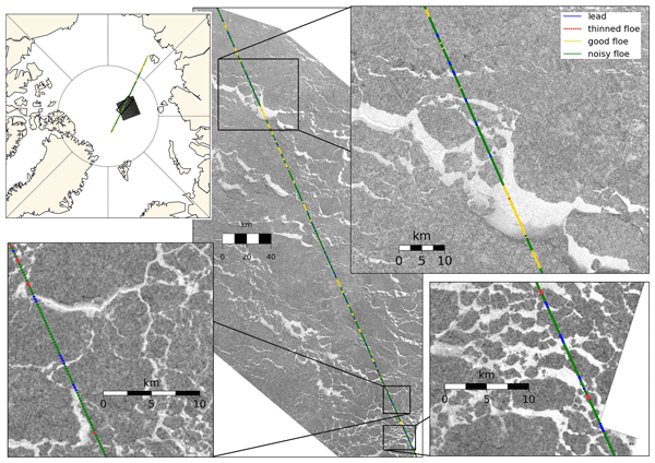
To calculate sea ice thickness from altimetry, returns from ice and leads need to be differentiated. During summer, melt ponds complicate this task, as they resemble leads. In this study, we improve a previously suggested neural network classifier by expanding the training dataset fivefold, tuning the network architecture and introducing an additional class for thinned floes. We show that this increases the accuracy from 77 ± 5 % to 84 ± 2 % and that more leads are found.
Valentin Ludwig, Caroline Ribere, Sara Fleury, Christian Haas, Michel Tsamados, Mahmoud El Hajj, Jerome Bouffard, Michele Scagliola, Marion Bocquet, Eric de Boisseson, Vincent Boulenger, Guillaume Boutin, Laurence Connor, Léo Edel, Stefan Hendricks, Ferran Hernández Macià, Marcus Huntemann, Lars Kaleschke, Frank Kauker, Jack Landy, Tom Megain, Alek Petty, Till Soya Rasmussen, Mads Hvid Ribergaard, Robert Ricker, Axel Schweiger, Hoyeon Shi, Xiangshan Tian-Kunze, Donghui Yi, and Alessandro Di Bella
EGUsphere, https://doi.org/10.5194/egusphere-2025-6201, https://doi.org/10.5194/egusphere-2025-6201, 2026
Short summary
Short summary
Our paper compares Arctic sea-ice thickness datasets from models, reanalyses, satellite-only, and multi-product sources. We validate them against Beaufort Sea reference data, compare large-scale products, and analyse time series. Cross-product biases range from 0.2–0.4 m, RMSDs from 0.4–0.9 m, and correlations from 0.5–0.8. We find no 2010–2023 trend, but 1995–2023 thinning of ~ 0.5 m in November and ~ 0.3 m in March.
Polona Itkin, Evgenii Salganik, Dmitry V. Divine, Arttu Jutila, Christian Katlein, Mara Neudert, Ian A. Raphael, and Robert Ricker
EGUsphere, https://doi.org/10.5194/egusphere-2025-6081, https://doi.org/10.5194/egusphere-2025-6081, 2025
Short summary
Short summary
We studied how Arctic ice ridges grow and change through winter and spring using a sensor that measures ice thickness without drilling. By comparing these measurements with data from aircraft, underwater surveys, and field work, we show that the sensor can detect both the full ridge thickness and its solid inner core. Our results reveal slow winter strengthening of ridges and highlight this method's value for understanding ice conditions and ecosystems.
Robert Ricker, Thomas Lavergne, Stefan Hendricks, Stephan Paul, Emily Down, Mari Anne Killie, and Marion Bocquet
The Cryosphere, 19, 3785–3803, https://doi.org/10.5194/tc-19-3785-2025, https://doi.org/10.5194/tc-19-3785-2025, 2025
Short summary
Short summary
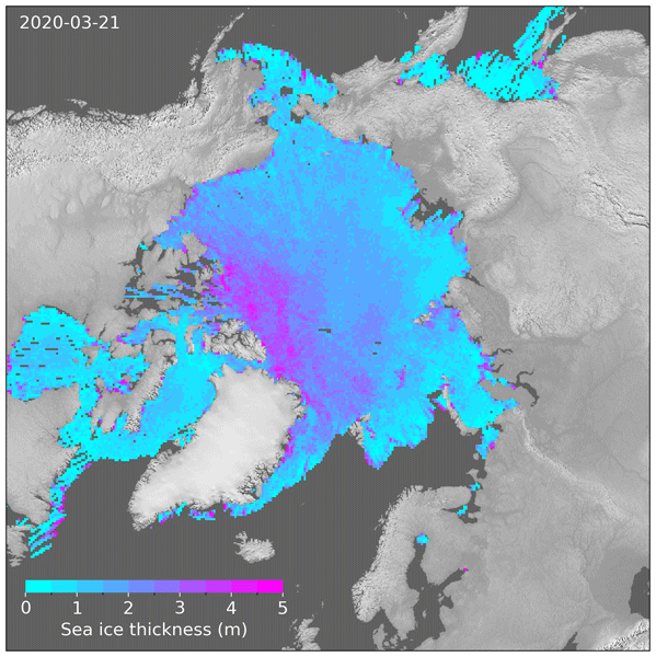
We developed a new method to map Arctic sea ice thickness daily using satellite measurements. We address a problem similar to motion blur in photography. Traditional methods collect satellite data over 1 month to get a full picture of Arctic sea ice thickness. But in the same way as in photos of moving objects, long exposure leads to motion blur, making it difficult to identify certain features in the sea ice maps. Our method corrects for this motion blur, providing a sharper view of the evolving sea ice.
Lars Kaleschke, Xiangshan Tian-Kunze, Stefan Hendricks, and Robert Ricker
Earth Syst. Sci. Data, 16, 3149–3170, https://doi.org/10.5194/essd-16-3149-2024, https://doi.org/10.5194/essd-16-3149-2024, 2024
Short summary
Short summary
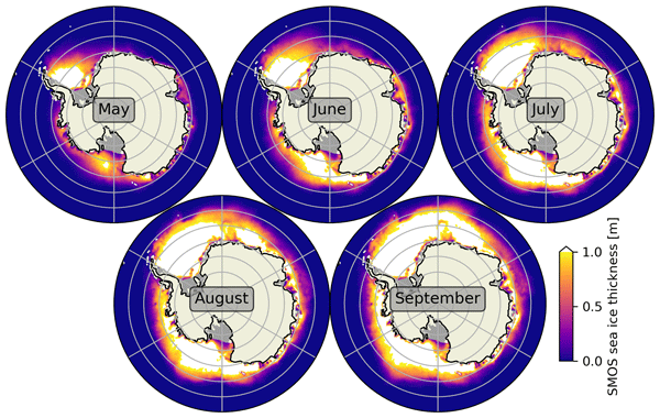
We describe a sea ice thickness dataset based on SMOS satellite measurements, initially designed for the Arctic but adapted for Antarctica. We validated it using limited Antarctic measurements. Our findings show promising results, with a small difference in thickness estimation and a strong correlation with validation data within the valid thickness range. However, improvements and synergies with other sensors are needed, especially for sea ice thicker than 1 m.

Vishnu Nandan, Rosemary Willatt, Robbie Mallett, Julienne Stroeve, Torsten Geldsetzer, Randall Scharien, Rasmus Tonboe, John Yackel, Jack Landy, David Clemens-Sewall, Arttu Jutila, David N. Wagner, Daniela Krampe, Marcus Huntemann, Mallik Mahmud, David Jensen, Thomas Newman, Stefan Hendricks, Gunnar Spreen, Amy Macfarlane, Martin Schneebeli, James Mead, Robert Ricker, Michael Gallagher, Claude Duguay, Ian Raphael, Chris Polashenski, Michel Tsamados, Ilkka Matero, and Mario Hoppmann
The Cryosphere, 17, 2211–2229, https://doi.org/10.5194/tc-17-2211-2023, https://doi.org/10.5194/tc-17-2211-2023, 2023
Short summary
Short summary
We show that wind redistributes snow on Arctic sea ice, and Ka- and Ku-band radar measurements detect both newly deposited snow and buried snow layers that can affect the accuracy of snow depth estimates on sea ice. Radar, laser, meteorological, and snow data were collected during the MOSAiC expedition. With frequent occurrence of storms in the Arctic, our results show that
wind-redistributed snow needs to be accounted for to improve snow depth estimates on sea ice from satellite radars.
Robert Ricker, Steven Fons, Arttu Jutila, Nils Hutter, Kyle Duncan, Sinead L. Farrell, Nathan T. Kurtz, and Renée Mie Fredensborg Hansen
The Cryosphere, 17, 1411–1429, https://doi.org/10.5194/tc-17-1411-2023, https://doi.org/10.5194/tc-17-1411-2023, 2023
Short summary
Short summary
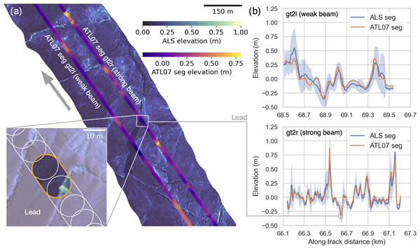
Information on sea ice surface topography is important for studies of sea ice as well as for ship navigation through ice. The ICESat-2 satellite senses the sea ice surface with six laser beams. To examine the accuracy of these measurements, we carried out a temporally coincident helicopter flight along the same ground track as the satellite and measured the sea ice surface topography with a laser scanner. This showed that ICESat-2 can see even bumps of only few meters in the sea ice cover.
Guillaume Boutin, Einar Ólason, Pierre Rampal, Heather Regan, Camille Lique, Claude Talandier, Laurent Brodeau, and Robert Ricker
The Cryosphere, 17, 617–638, https://doi.org/10.5194/tc-17-617-2023, https://doi.org/10.5194/tc-17-617-2023, 2023
Short summary
Short summary
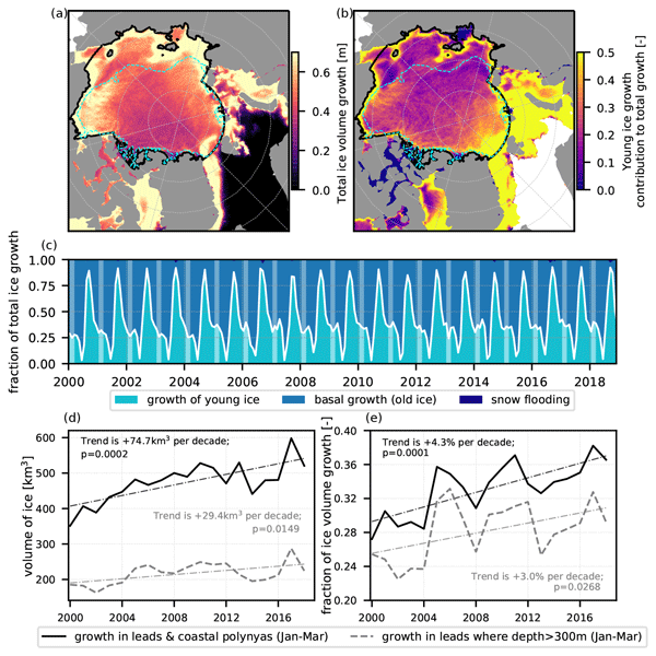
Sea ice cover in the Arctic is full of cracks, which we call leads. We suspect that these leads play a role for atmosphere–ocean interactions in polar regions, but their importance remains challenging to estimate. We use a new ocean–sea ice model with an original way of representing sea ice dynamics to estimate their impact on winter sea ice production. This model successfully represents sea ice evolution from 2000 to 2018, and we find that about 30 % of ice production takes place in leads.
Francesca Doglioni, Robert Ricker, Benjamin Rabe, Alexander Barth, Charles Troupin, and Torsten Kanzow
Earth Syst. Sci. Data, 15, 225–263, https://doi.org/10.5194/essd-15-225-2023, https://doi.org/10.5194/essd-15-225-2023, 2023
Short summary
Short summary
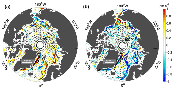
This paper presents a new satellite-derived gridded dataset, including 10 years of sea surface height and geostrophic velocity at monthly resolution, over the Arctic ice-covered and ice-free regions, up to 88° N. We assess the dataset by comparison to independent satellite and mooring data. Results correlate well with independent satellite data at monthly timescales, and the geostrophic velocity fields can resolve seasonal to interannual variability of boundary currents wider than about 50 km.
Jinfei Wang, Chao Min, Robert Ricker, Qian Shi, Bo Han, Stefan Hendricks, Renhao Wu, and Qinghua Yang
The Cryosphere, 16, 4473–4490, https://doi.org/10.5194/tc-16-4473-2022, https://doi.org/10.5194/tc-16-4473-2022, 2022
Short summary
Short summary
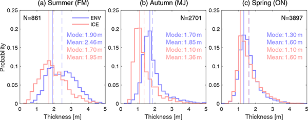
The differences between Envisat and ICESat sea ice thickness (SIT) reveal significant temporal and spatial variations. Our findings suggest that both overestimation of Envisat sea ice freeboard, potentially caused by radar backscatter originating from inside the snow layer, and the AMSR-E snow depth biases and sea ice density uncertainties can possibly account for the differences between Envisat and ICESat SIT.
Julienne Stroeve, Vishnu Nandan, Rosemary Willatt, Ruzica Dadic, Philip Rostosky, Michael Gallagher, Robbie Mallett, Andrew Barrett, Stefan Hendricks, Rasmus Tonboe, Michelle McCrystall, Mark Serreze, Linda Thielke, Gunnar Spreen, Thomas Newman, John Yackel, Robert Ricker, Michel Tsamados, Amy Macfarlane, Henna-Reetta Hannula, and Martin Schneebeli
The Cryosphere, 16, 4223–4250, https://doi.org/10.5194/tc-16-4223-2022, https://doi.org/10.5194/tc-16-4223-2022, 2022
Short summary
Short summary
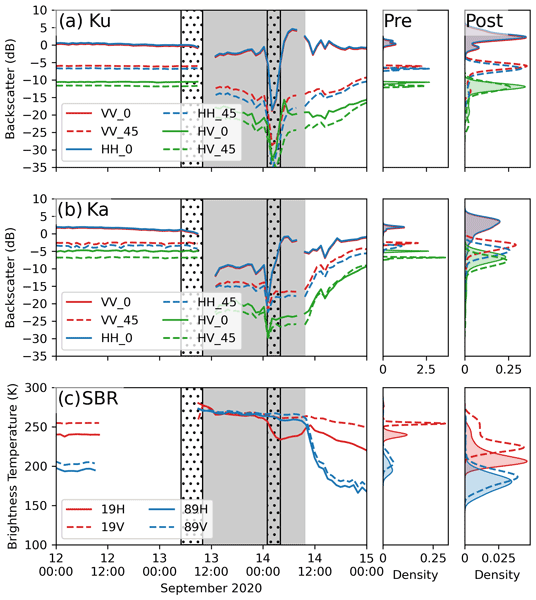
Impacts of rain on snow (ROS) on satellite-retrieved sea ice variables remain to be fully understood. This study evaluates the impacts of ROS over sea ice on active and passive microwave data collected during the 2019–20 MOSAiC expedition. Rainfall and subsequent refreezing of the snowpack significantly altered emitted and backscattered radar energy, laying important groundwork for understanding their impacts on operational satellite retrievals of various sea ice geophysical variables.
David N. Wagner, Matthew D. Shupe, Christopher Cox, Ola G. Persson, Taneil Uttal, Markus M. Frey, Amélie Kirchgaessner, Martin Schneebeli, Matthias Jaggi, Amy R. Macfarlane, Polona Itkin, Stefanie Arndt, Stefan Hendricks, Daniela Krampe, Marcel Nicolaus, Robert Ricker, Julia Regnery, Nikolai Kolabutin, Egor Shimanshuck, Marc Oggier, Ian Raphael, Julienne Stroeve, and Michael Lehning
The Cryosphere, 16, 2373–2402, https://doi.org/10.5194/tc-16-2373-2022, https://doi.org/10.5194/tc-16-2373-2022, 2022
Short summary
Short summary
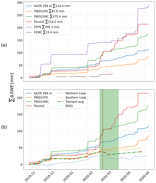
Based on measurements of the snow cover over sea ice and atmospheric measurements, we estimate snowfall and snow accumulation for the MOSAiC ice floe, between November 2019 and May 2020. For this period, we estimate 98–114 mm of precipitation. We suggest that about 34 mm of snow water equivalent accumulated until the end of April 2020 and that at least about 50 % of the precipitated snow was eroded or sublimated. Further, we suggest explanations for potential snowfall overestimation.
Klaus Dethloff, Wieslaw Maslowski, Stefan Hendricks, Younjoo J. Lee, Helge F. Goessling, Thomas Krumpen, Christian Haas, Dörthe Handorf, Robert Ricker, Vladimir Bessonov, John J. Cassano, Jaclyn Clement Kinney, Robert Osinski, Markus Rex, Annette Rinke, Julia Sokolova, and Anja Sommerfeld
The Cryosphere, 16, 981–1005, https://doi.org/10.5194/tc-16-981-2022, https://doi.org/10.5194/tc-16-981-2022, 2022
Short summary
Short summary
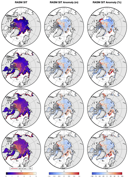
Sea ice thickness anomalies during the MOSAiC (Multidisciplinary drifting Observatory for the Study of Arctic Climate) winter in January, February and March 2020 were simulated with the coupled Regional Arctic climate System Model (RASM) and compared with CryoSat-2/SMOS satellite data. Hindcast and ensemble simulations indicate that the sea ice anomalies are driven by nonlinear interactions between ice growth processes and wind-driven sea-ice transports, with dynamics playing a dominant role.
Arttu Jutila, Stefan Hendricks, Robert Ricker, Luisa von Albedyll, Thomas Krumpen, and Christian Haas
The Cryosphere, 16, 259–275, https://doi.org/10.5194/tc-16-259-2022, https://doi.org/10.5194/tc-16-259-2022, 2022
Short summary
Short summary
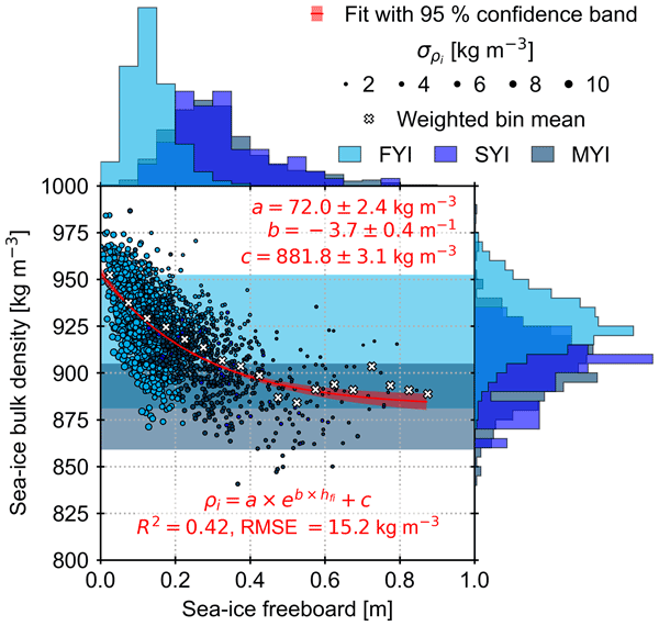
Sea-ice thickness retrieval from satellite altimeters relies on assumed sea-ice density values because density cannot be measured from space. We derived bulk densities for different ice types using airborne laser, radar, and electromagnetic induction sounding measurements. Compared to previous studies, we found high bulk density values due to ice deformation and younger ice cover. Using sea-ice freeboard, we derived a sea-ice bulk density parameterisation that can be applied to satellite data.
Marion Bocquet, Robert Ricker, Torbjörn Kagel, Stefan Kern, Thomas Lavergne, Emily Down, and Stefan Hendricks
EGUsphere, https://doi.org/10.5194/egusphere-2026-4063, https://doi.org/10.5194/egusphere-2026-4063, 2026
Short summary
Short summary
Antarctic sea ice has changed dramatically in recent years, highlighting the need for better information on ice and snow thickness. We combined measurements from several satellites with ice motion data to create a daily updated record spanning from 2018 to 2025. By considering the ice drift in the sea-ice thickness gridding process, we captured finer spatial detail and produced more consistent estimates. The results provide a stronger basis for monitoring ongoing changes in the Southern Ocean.
Julien Meloche, Melody Sandells, Henning Löwe, Nick Rutter, Ghislain Picard, Richard Essery, Randall K. Scharien, Alexandre Langlois, Matthias Jaggi, Josh King, Peter Toose, Michele Scagliola, Jerome Bouffard, Alessandro Di Bella, and Christian Haas
EGUsphere, https://doi.org/10.5194/egusphere-2026-3615, https://doi.org/10.5194/egusphere-2026-3615, 2026
This preprint is open for discussion and under review for The Cryosphere (TC).
Short summary
Short summary
Sea ice thickness is essential for climate studies. Radar altimetry has provided sea ice thickness measurements, but uncertainty arises from the interaction of the signal with the snow cover. Therefore, modelling the signal interaction with the snow is necessary to improve retrieval. A radar model was used to simulate the radar signal from the snow-covered sea ice. This work paved the way to improved physical algorithms to retrieve snow depth and sea ice thickness for radar altimeter missions.
Luisa von Albedyll, Robert Ricker, Frank Kauker, Daniel Krogmann, and Stefan Hendricks
EGUsphere, https://doi.org/10.5194/egusphere-2026-3122, https://doi.org/10.5194/egusphere-2026-3122, 2026
Short summary
Short summary
Using satellite observations and model simulations, we studied winter Arctic sea ice thickness change. Separating thickening from ridging and thinning from lead opening showed that dynamic processes contribute nearly as much to winter ice growth as freezing. Between 2002 and 2020, dynamic thickness change increased linked to stronger sea ice deformation. This is consistent with the idea that sea ice dynamics partly counteract thinning of Arctic sea ice during ongoing climate warming.
Ida Lundtorp Olsen, Henriette Skourup, Heidi Sallila, Stefan Hendricks, Renée Mie Fredensborg Hansen, Stefan Kern, Stephan Paul, Marion Bocquet, Sara Fleury, Dmitry Divine, and Eero Rinne
Earth Syst. Sci. Data, 18, 2469–2505, https://doi.org/10.5194/essd-18-2469-2026, https://doi.org/10.5194/essd-18-2469-2026, 2026
Short summary
Short summary
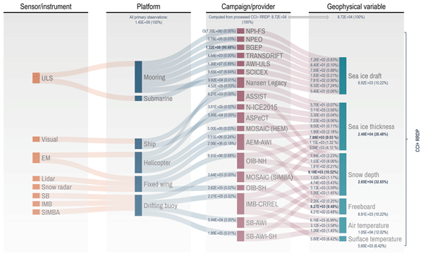
Discover the latest advancements in sea ice research with our comprehensive Climate Change Initiative (CCI) sea ice thickness (SIT) Round Robin Data Package (RRDP). This pioneering collection contains reference measurements from 1960 to 2024 from airborne sensors, buoys, visual observations and sonar and covers the polar regions from 1993 to 2024, providing crucial reference measurements for validating satellite-derived sea ice thickness.
Rasmus Tage Tonboe, Vishnu Nandan, Marcus Huntemann, Julienne Stroeve, Randall Scharien, John Yackel, Lars Kaleschke, Hoyeon Shi, and Tânia Casal
EGUsphere, https://doi.org/10.5194/egusphere-2026-1440, https://doi.org/10.5194/egusphere-2026-1440, 2026
Short summary
Short summary
Scattering and absorption from air bubbles, voids, and brine pockets significantly affect radar and microwave radiometer measurements of sea ice and light propagation through sea ice. Here, we used a high-resolution dataset, collected during the 2019–20 MOSAiC expedition, of thin ice slices of various Arctic sea ice types to estimate the autocorrelation length and density of the inclusions. The data can be used to initialize sea ice scattering models and for understanding satellite data.
Niklas Neckel, Niels Fuchs, Jonathan Kolar, Thomas Kordes, and Christian Haas
EGUsphere, https://doi.org/10.5194/egusphere-2026-714, https://doi.org/10.5194/egusphere-2026-714, 2026
Short summary
Short summary
This study summarizes challenges of operating consumer-grade UAVs over high-latitude Arctic pack ice. High ice-floe drift and the lack of commercial grid-mission solutions north of 85° N hinder the generation of void-free orthomosaics and DEMs. We present an autonomous high-latitude grid-flight approach with pre- and post-flight drift correction, applied during ArcWatch-2 (Aug/Sep 2024), enabling ice thickness, surface type and pond depth retrievals.
Anne Braakmann-Folgmann, Jack C. Landy, Geoffrey Dawson, and Robert Ricker
The Cryosphere, 20, 905–929, https://doi.org/10.5194/tc-20-905-2026, https://doi.org/10.5194/tc-20-905-2026, 2026
Short summary
Short summary
To calculate sea ice thickness from altimetry, returns from ice and leads need to be differentiated. During summer, melt ponds complicate this task, as they resemble leads. In this study, we improve a previously suggested neural network classifier by expanding the training dataset fivefold, tuning the network architecture and introducing an additional class for thinned floes. We show that this increases the accuracy from 77 ± 5 % to 84 ± 2 % and that more leads are found.
Valentin Ludwig, Caroline Ribere, Sara Fleury, Christian Haas, Michel Tsamados, Mahmoud El Hajj, Jerome Bouffard, Michele Scagliola, Marion Bocquet, Eric de Boisseson, Vincent Boulenger, Guillaume Boutin, Laurence Connor, Léo Edel, Stefan Hendricks, Ferran Hernández Macià, Marcus Huntemann, Lars Kaleschke, Frank Kauker, Jack Landy, Tom Megain, Alek Petty, Till Soya Rasmussen, Mads Hvid Ribergaard, Robert Ricker, Axel Schweiger, Hoyeon Shi, Xiangshan Tian-Kunze, Donghui Yi, and Alessandro Di Bella
EGUsphere, https://doi.org/10.5194/egusphere-2025-6201, https://doi.org/10.5194/egusphere-2025-6201, 2026
Short summary
Short summary
Our paper compares Arctic sea-ice thickness datasets from models, reanalyses, satellite-only, and multi-product sources. We validate them against Beaufort Sea reference data, compare large-scale products, and analyse time series. Cross-product biases range from 0.2–0.4 m, RMSDs from 0.4–0.9 m, and correlations from 0.5–0.8. We find no 2010–2023 trend, but 1995–2023 thinning of ~ 0.5 m in November and ~ 0.3 m in March.
Polona Itkin, Evgenii Salganik, Dmitry V. Divine, Arttu Jutila, Christian Katlein, Mara Neudert, Ian A. Raphael, and Robert Ricker
EGUsphere, https://doi.org/10.5194/egusphere-2025-6081, https://doi.org/10.5194/egusphere-2025-6081, 2025
Short summary
Short summary
We studied how Arctic ice ridges grow and change through winter and spring using a sensor that measures ice thickness without drilling. By comparing these measurements with data from aircraft, underwater surveys, and field work, we show that the sensor can detect both the full ridge thickness and its solid inner core. Our results reveal slow winter strengthening of ridges and highlight this method's value for understanding ice conditions and ecosystems.
Lena G. Buth, Thomas Krumpen, Niklas Neckel, Melinda A. Webster, Gerit Birnbaum, Niels Fuchs, Philipp Heuser, Ole Johannsen, and Christian Haas
The Cryosphere, 19, 6527–6545, https://doi.org/10.5194/tc-19-6527-2025, https://doi.org/10.5194/tc-19-6527-2025, 2025
Short summary
Short summary
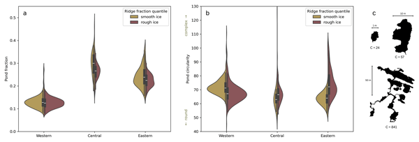
Arctic sea ice is becoming smoother, raising the question of how these changes affect melt pond coverage and thereby surface albedo. Using airborne imagery and laser altimeter data, we investigated how pressure ridges influence melt ponds. The presence of ridges does not directly control pond fraction, but it does influence pond size distribution and pond geometry. Small ponds have a more complex shape on rough ice than on smooth ice, while the opposite is true for large ponds.
Steven Franke, Mara Neudert, Veit Helm, Arttu Jutila, Océane Hames, Niklas Neckel, Stefanie Arndt, and Christian Haas
The Cryosphere, 19, 6319–6339, https://doi.org/10.5194/tc-19-6319-2025, https://doi.org/10.5194/tc-19-6319-2025, 2025
Short summary
Short summary
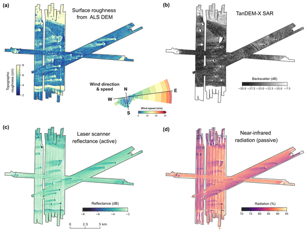
Our research explored how icebergs affect the distribution of snow and flooding on Antarctic coastal sea ice. Using aircraft-based radar and laser scanning, we found that icebergs create thick snow drifts on their wind-facing sides and leave snow-free zones in their lee. The weight of these snow drifts often causes the ice below to flood, forming slush. These patterns, driven by wind and iceberg placement, are crucial for understanding sea ice changes and improving climate models.
Robert Ricker, Thomas Lavergne, Stefan Hendricks, Stephan Paul, Emily Down, Mari Anne Killie, and Marion Bocquet
The Cryosphere, 19, 3785–3803, https://doi.org/10.5194/tc-19-3785-2025, https://doi.org/10.5194/tc-19-3785-2025, 2025
Short summary
Short summary
We developed a new method to map Arctic sea ice thickness daily using satellite measurements. We address a problem similar to motion blur in photography. Traditional methods collect satellite data over 1 month to get a full picture of Arctic sea ice thickness. But in the same way as in photos of moving objects, long exposure leads to motion blur, making it difficult to identify certain features in the sea ice maps. Our method corrects for this motion blur, providing a sharper view of the evolving sea ice.
Ole Zeising, Tore Hattermann, Lars Kaleschke, Sophie Berger, Olaf Boebel, Reinhard Drews, M. Reza Ershadi, Tanja Fromm, Frank Pattyn, Daniel Steinhage, and Olaf Eisen
The Cryosphere, 19, 2837–2854, https://doi.org/10.5194/tc-19-2837-2025, https://doi.org/10.5194/tc-19-2837-2025, 2025
Short summary
Short summary
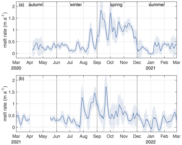
Basal melting of ice shelves impacts the mass loss of the Antarctic Ice Sheet. This study focuses on the Ekström Ice Shelf in East Antarctica, using multiyear data from an autonomous radar system. Results show a surprising seasonal pattern of high melt rates in winter and spring. The seasonalities of sea-ice growth and ocean density indicate that, in winter, dense water enhances plume activity and melt rates. Understanding these dynamics is crucial for improving future mass balance projections.
Lena Happ, Sonali Patil, Stefan Hendricks, Riccardo Fellegara, Lars Kaleschke, and Andreas Gerndt
ISPRS Ann. Photogramm. Remote Sens. Spatial Inf. Sci., X-G-2025, 333–340, https://doi.org/10.5194/isprs-annals-X-G-2025-333-2025, https://doi.org/10.5194/isprs-annals-X-G-2025-333-2025, 2025
Rui Xu, Chaofang Zhao, Stefanie Arndt, and Christian Haas
The Cryosphere, 18, 5769–5788, https://doi.org/10.5194/tc-18-5769-2024, https://doi.org/10.5194/tc-18-5769-2024, 2024
Short summary
Short summary
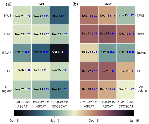
The onset of snowmelt on Antarctic sea ice is an important indicator of sea ice change. In this study, we used two radar scatterometers to detect the onset of snowmelt on perennial Antarctic sea ice. Results show that since 2007, snowmelt onset has demonstrated strong interannual and regional variabilities. We also found that the difference in snowmelt onsets between the two scatterometers is closely related to snow metamorphism.
Yi Zhou, Xianwei Wang, Ruibo Lei, Arttu Jutila, Donald K. Perovich, Luisa von Albedyll, Dmitry V. Divine, Yu Zhang, and Christian Haas
EGUsphere, https://doi.org/10.5194/egusphere-2024-2821, https://doi.org/10.5194/egusphere-2024-2821, 2024
Preprint archived
Short summary
Short summary
This study examines how the bulk density of Arctic sea ice varies seasonally, a factor often overlooked in satellite measurements of sea ice thickness. From October to April, we found significant seasonal variations in sea ice bulk density at different spatial scales using direct observations as well as airborne and satellite data. New models were then developed to indirectly predict sea ice bulk density. This advance can improve our ability to monitor changes in Arctic sea ice.
Lars Kaleschke, Xiangshan Tian-Kunze, Stefan Hendricks, and Robert Ricker
Earth Syst. Sci. Data, 16, 3149–3170, https://doi.org/10.5194/essd-16-3149-2024, https://doi.org/10.5194/essd-16-3149-2024, 2024
Short summary
Short summary
We describe a sea ice thickness dataset based on SMOS satellite measurements, initially designed for the Arctic but adapted for Antarctica. We validated it using limited Antarctic measurements. Our findings show promising results, with a small difference in thickness estimation and a strong correlation with validation data within the valid thickness range. However, improvements and synergies with other sensors are needed, especially for sea ice thicker than 1 m.
Gemma M. Brett, Greg H. Leonard, Wolfgang Rack, Christian Haas, Patricia J. Langhorne, Natalie J. Robinson, and Anne Irvin
The Cryosphere, 18, 3049–3066, https://doi.org/10.5194/tc-18-3049-2024, https://doi.org/10.5194/tc-18-3049-2024, 2024
Short summary
Short summary
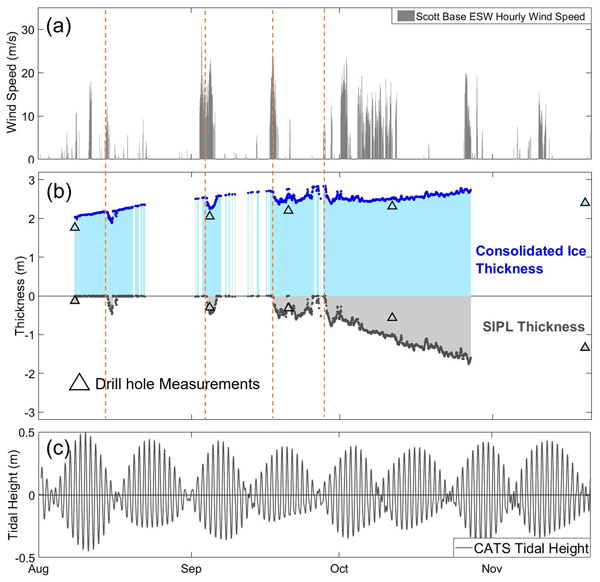
Glacial meltwater with ice crystals flows from beneath ice shelves, causing thicker sea ice with sub-ice platelet layers (SIPLs) beneath. Thicker sea ice and SIPL reveal where and how much meltwater is outflowing. We collected continuous measurements of sea ice and SIPL. In winter, we observed rapid SIPL growth with strong winds. In spring, SIPLs grew when tides caused offshore circulation. Wind-driven and tidal circulation influence glacial meltwater outflow from ice shelf cavities.
Niels Fuchs, Luisa von Albedyll, Gerit Birnbaum, Felix Linhardt, Natascha Oppelt, and Christian Haas
The Cryosphere, 18, 2991–3015, https://doi.org/10.5194/tc-18-2991-2024, https://doi.org/10.5194/tc-18-2991-2024, 2024
Short summary
Short summary
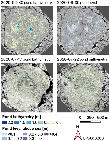
Melt ponds are key components of the Arctic sea ice system, yet methods to derive comprehensive pond depth data are missing. We present a shallow-water bathymetry retrieval to derive this elementary pond property at high spatial resolution from aerial images. The retrieval method is presented in a user-friendly way to facilitate replication. Furthermore, we provide pond properties on the MOSAiC expedition floe, giving insights into the three-dimensional pond evolution before and after drainage.
Yi Zhou, Xianwei Wang, Ruibo Lei, Luisa von Albedyll, Donald K. Perovich, Yu Zhang, and Christian Haas
EGUsphere, https://doi.org/10.5194/egusphere-2024-1240, https://doi.org/10.5194/egusphere-2024-1240, 2024
Preprint archived
Short summary
Short summary
This study examines how the density of Arctic sea ice varies seasonally, a factor often overlooked in satellite measurements of sea ice thickness. From October to April, using direct observations and satellite data, we found that sea ice density decreases significantly until mid-January due to increased porosity as the ice ages, and then stabilizes until April. We then developed new models to estimate sea ice density. This advance can improve our ability to monitor changes in Arctic sea ice.

Karl Kortum, Suman Singha, Gunnar Spreen, Nils Hutter, Arttu Jutila, and Christian Haas
The Cryosphere, 18, 2207–2222, https://doi.org/10.5194/tc-18-2207-2024, https://doi.org/10.5194/tc-18-2207-2024, 2024
Short summary
Short summary
A dataset of 20 radar satellite acquisitions and near-simultaneous helicopter-based surveys of the ice topography during the MOSAiC expedition is constructed and used to train a variety of deep learning algorithms. The results give realistic insights into the accuracy of retrieval of measured ice classes using modern deep learning models. The models able to learn from the spatial distribution of the measured sea ice classes are shown to have a clear advantage over those that cannot.
Luisa von Albedyll, Stefan Hendricks, Nils Hutter, Dmitrii Murashkin, Lars Kaleschke, Sascha Willmes, Linda Thielke, Xiangshan Tian-Kunze, Gunnar Spreen, and Christian Haas
The Cryosphere, 18, 1259–1285, https://doi.org/10.5194/tc-18-1259-2024, https://doi.org/10.5194/tc-18-1259-2024, 2024
Short summary
Short summary
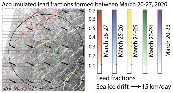
Leads (openings in sea ice cover) are created by sea ice dynamics. Because they are important for many processes in the Arctic winter climate, we aim to detect them with satellites. We present two new techniques to detect lead widths of a few hundred meters at high spatial resolution (700 m) and independent of clouds or sun illumination. We use the MOSAiC drift 2019–2020 in the Arctic for our case study and compare our new products to other existing lead products.
Haokui Xu, Brooke Medley, Leung Tsang, Joel T. Johnson, Kenneth C. Jezek, Marco Brogioni, and Lars Kaleschke
The Cryosphere, 17, 2793–2809, https://doi.org/10.5194/tc-17-2793-2023, https://doi.org/10.5194/tc-17-2793-2023, 2023
Short summary
Short summary
The density profile of polar ice sheets is a major unknown in estimating the mass loss using lidar tomography methods. In this paper, we show that combing the active radar data and passive radiometer data can provide an estimation of density properties using the new model we implemented in this paper. The new model includes the short and long timescale variations in the firn and also the refrozen layers which are not included in the previous modeling work.
Vishnu Nandan, Rosemary Willatt, Robbie Mallett, Julienne Stroeve, Torsten Geldsetzer, Randall Scharien, Rasmus Tonboe, John Yackel, Jack Landy, David Clemens-Sewall, Arttu Jutila, David N. Wagner, Daniela Krampe, Marcus Huntemann, Mallik Mahmud, David Jensen, Thomas Newman, Stefan Hendricks, Gunnar Spreen, Amy Macfarlane, Martin Schneebeli, James Mead, Robert Ricker, Michael Gallagher, Claude Duguay, Ian Raphael, Chris Polashenski, Michel Tsamados, Ilkka Matero, and Mario Hoppmann
The Cryosphere, 17, 2211–2229, https://doi.org/10.5194/tc-17-2211-2023, https://doi.org/10.5194/tc-17-2211-2023, 2023
Short summary
Short summary
We show that wind redistributes snow on Arctic sea ice, and Ka- and Ku-band radar measurements detect both newly deposited snow and buried snow layers that can affect the accuracy of snow depth estimates on sea ice. Radar, laser, meteorological, and snow data were collected during the MOSAiC expedition. With frequent occurrence of storms in the Arctic, our results show that
wind-redistributed snow needs to be accounted for to improve snow depth estimates on sea ice from satellite radars.
Karina von Schuckmann, Audrey Minière, Flora Gues, Francisco José Cuesta-Valero, Gottfried Kirchengast, Susheel Adusumilli, Fiammetta Straneo, Michaël Ablain, Richard P. Allan, Paul M. Barker, Hugo Beltrami, Alejandro Blazquez, Tim Boyer, Lijing Cheng, John Church, Damien Desbruyeres, Han Dolman, Catia M. Domingues, Almudena García-García, Donata Giglio, John E. Gilson, Maximilian Gorfer, Leopold Haimberger, Maria Z. Hakuba, Stefan Hendricks, Shigeki Hosoda, Gregory C. Johnson, Rachel Killick, Brian King, Nicolas Kolodziejczyk, Anton Korosov, Gerhard Krinner, Mikael Kuusela, Felix W. Landerer, Moritz Langer, Thomas Lavergne, Isobel Lawrence, Yuehua Li, John Lyman, Florence Marti, Ben Marzeion, Michael Mayer, Andrew H. MacDougall, Trevor McDougall, Didier Paolo Monselesan, Jan Nitzbon, Inès Otosaka, Jian Peng, Sarah Purkey, Dean Roemmich, Kanako Sato, Katsunari Sato, Abhishek Savita, Axel Schweiger, Andrew Shepherd, Sonia I. Seneviratne, Leon Simons, Donald A. Slater, Thomas Slater, Andrea K. Steiner, Toshio Suga, Tanguy Szekely, Wim Thiery, Mary-Louise Timmermans, Inne Vanderkelen, Susan E. Wjiffels, Tonghua Wu, and Michael Zemp
Earth Syst. Sci. Data, 15, 1675–1709, https://doi.org/10.5194/essd-15-1675-2023, https://doi.org/10.5194/essd-15-1675-2023, 2023
Short summary
Short summary
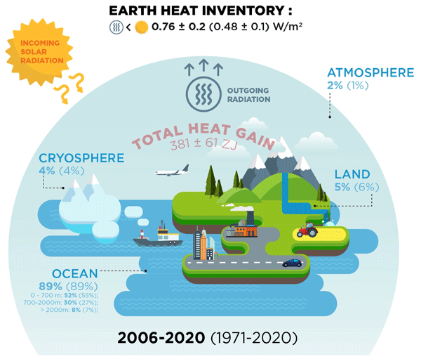
Earth's climate is out of energy balance, and this study quantifies how much heat has consequently accumulated over the past decades (ocean: 89 %, land: 6 %, cryosphere: 4 %, atmosphere: 1 %). Since 1971, this accumulated heat reached record values at an increasing pace. The Earth heat inventory provides a comprehensive view on the status and expectation of global warming, and we call for an implementation of this global climate indicator into the Paris Agreement’s Global Stocktake.
Robert Ricker, Steven Fons, Arttu Jutila, Nils Hutter, Kyle Duncan, Sinead L. Farrell, Nathan T. Kurtz, and Renée Mie Fredensborg Hansen
The Cryosphere, 17, 1411–1429, https://doi.org/10.5194/tc-17-1411-2023, https://doi.org/10.5194/tc-17-1411-2023, 2023
Short summary
Short summary
Information on sea ice surface topography is important for studies of sea ice as well as for ship navigation through ice. The ICESat-2 satellite senses the sea ice surface with six laser beams. To examine the accuracy of these measurements, we carried out a temporally coincident helicopter flight along the same ground track as the satellite and measured the sea ice surface topography with a laser scanner. This showed that ICESat-2 can see even bumps of only few meters in the sea ice cover.
Felix L. Müller, Stephan Paul, Stefan Hendricks, and Denise Dettmering
The Cryosphere, 17, 809–825, https://doi.org/10.5194/tc-17-809-2023, https://doi.org/10.5194/tc-17-809-2023, 2023
Short summary
Short summary
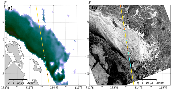
Thinning sea ice has significant impacts on the energy exchange between the atmosphere and the ocean. In this study we present visual and quantitative comparisons of thin-ice detections obtained from classified Cryosat-2 radar reflections and thin-ice-thickness estimates derived from MODIS thermal-infrared imagery. In addition to good comparability, the results of the study indicate the potential for a deeper understanding of sea ice in the polar seas and improved processing of altimeter data.
Guillaume Boutin, Einar Ólason, Pierre Rampal, Heather Regan, Camille Lique, Claude Talandier, Laurent Brodeau, and Robert Ricker
The Cryosphere, 17, 617–638, https://doi.org/10.5194/tc-17-617-2023, https://doi.org/10.5194/tc-17-617-2023, 2023
Short summary
Short summary
Sea ice cover in the Arctic is full of cracks, which we call leads. We suspect that these leads play a role for atmosphere–ocean interactions in polar regions, but their importance remains challenging to estimate. We use a new ocean–sea ice model with an original way of representing sea ice dynamics to estimate their impact on winter sea ice production. This model successfully represents sea ice evolution from 2000 to 2018, and we find that about 30 % of ice production takes place in leads.
Marco Brogioni, Mark J. Andrews, Stefano Urbini, Kenneth C. Jezek, Joel T. Johnson, Marion Leduc-Leballeur, Giovanni Macelloni, Stephen F. Ackley, Alexandra Bringer, Ludovic Brucker, Oguz Demir, Giacomo Fontanelli, Caglar Yardim, Lars Kaleschke, Francesco Montomoli, Leung Tsang, Silvia Becagli, and Massimo Frezzotti
The Cryosphere, 17, 255–278, https://doi.org/10.5194/tc-17-255-2023, https://doi.org/10.5194/tc-17-255-2023, 2023
Short summary
Short summary
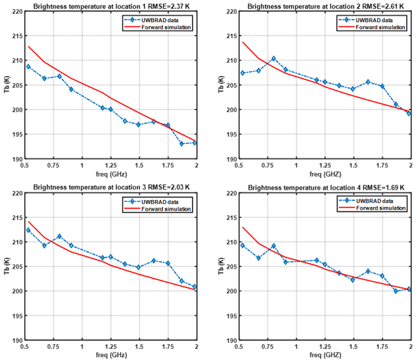
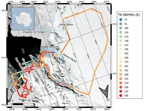
In 2018 the first Antarctic campaign of UWBRAD was carried out. UWBRAD is a new radiometer able to collect microwave spectral signatures over 0.5–2 GHz, thus outperforming existing similar sensors. It allows us to probe thicker sea ice and ice sheet down to the bedrock. In this work we tried to assess the UWBRAD potentials for sea ice, glaciers, ice shelves and buried lakes. We also highlighted the wider range of information the spectral signature can provide to glaciological studies.
Francesca Doglioni, Robert Ricker, Benjamin Rabe, Alexander Barth, Charles Troupin, and Torsten Kanzow
Earth Syst. Sci. Data, 15, 225–263, https://doi.org/10.5194/essd-15-225-2023, https://doi.org/10.5194/essd-15-225-2023, 2023
Short summary
Short summary
This paper presents a new satellite-derived gridded dataset, including 10 years of sea surface height and geostrophic velocity at monthly resolution, over the Arctic ice-covered and ice-free regions, up to 88° N. We assess the dataset by comparison to independent satellite and mooring data. Results correlate well with independent satellite data at monthly timescales, and the geostrophic velocity fields can resolve seasonal to interannual variability of boundary currents wider than about 50 km.
Julian Gutt, Stefanie Arndt, David Keith Alan Barnes, Horst Bornemann, Thomas Brey, Olaf Eisen, Hauke Flores, Huw Griffiths, Christian Haas, Stefan Hain, Tore Hattermann, Christoph Held, Mario Hoppema, Enrique Isla, Markus Janout, Céline Le Bohec, Heike Link, Felix Christopher Mark, Sebastien Moreau, Scarlett Trimborn, Ilse van Opzeeland, Hans-Otto Pörtner, Fokje Schaafsma, Katharina Teschke, Sandra Tippenhauer, Anton Van de Putte, Mia Wege, Daniel Zitterbart, and Dieter Piepenburg
Biogeosciences, 19, 5313–5342, https://doi.org/10.5194/bg-19-5313-2022, https://doi.org/10.5194/bg-19-5313-2022, 2022
Short summary
Short summary
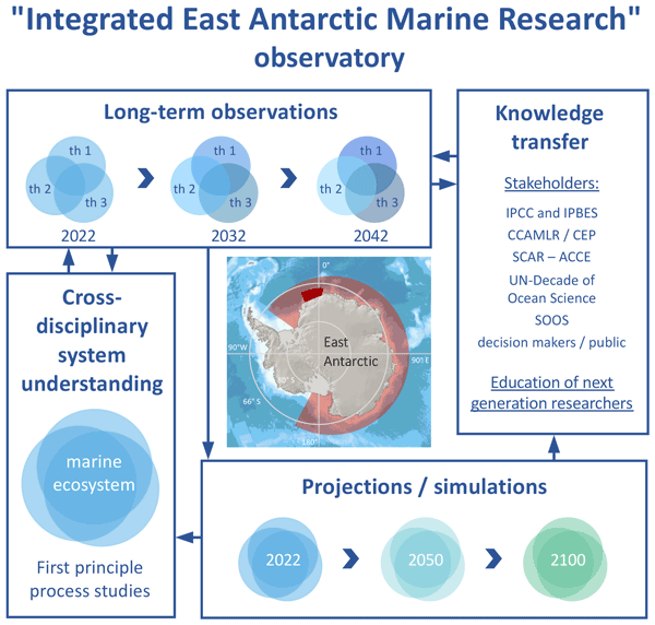
Long-term ecological observations are key to assess, understand and predict impacts of environmental change on biotas. We present a multidisciplinary framework for such largely lacking investigations in the East Antarctic Southern Ocean, combined with case studies, experimental and modelling work. As climate change is still minor here but is projected to start soon, the timely implementation of this framework provides the unique opportunity to document its ecological impacts from the very onset.
Jinfei Wang, Chao Min, Robert Ricker, Qian Shi, Bo Han, Stefan Hendricks, Renhao Wu, and Qinghua Yang
The Cryosphere, 16, 4473–4490, https://doi.org/10.5194/tc-16-4473-2022, https://doi.org/10.5194/tc-16-4473-2022, 2022
Short summary
Short summary
The differences between Envisat and ICESat sea ice thickness (SIT) reveal significant temporal and spatial variations. Our findings suggest that both overestimation of Envisat sea ice freeboard, potentially caused by radar backscatter originating from inside the snow layer, and the AMSR-E snow depth biases and sea ice density uncertainties can possibly account for the differences between Envisat and ICESat SIT.
Julienne Stroeve, Vishnu Nandan, Rosemary Willatt, Ruzica Dadic, Philip Rostosky, Michael Gallagher, Robbie Mallett, Andrew Barrett, Stefan Hendricks, Rasmus Tonboe, Michelle McCrystall, Mark Serreze, Linda Thielke, Gunnar Spreen, Thomas Newman, John Yackel, Robert Ricker, Michel Tsamados, Amy Macfarlane, Henna-Reetta Hannula, and Martin Schneebeli
The Cryosphere, 16, 4223–4250, https://doi.org/10.5194/tc-16-4223-2022, https://doi.org/10.5194/tc-16-4223-2022, 2022
Short summary
Short summary
Impacts of rain on snow (ROS) on satellite-retrieved sea ice variables remain to be fully understood. This study evaluates the impacts of ROS over sea ice on active and passive microwave data collected during the 2019–20 MOSAiC expedition. Rainfall and subsequent refreezing of the snowpack significantly altered emitted and backscattered radar energy, laying important groundwork for understanding their impacts on operational satellite retrievals of various sea ice geophysical variables.
David N. Wagner, Matthew D. Shupe, Christopher Cox, Ola G. Persson, Taneil Uttal, Markus M. Frey, Amélie Kirchgaessner, Martin Schneebeli, Matthias Jaggi, Amy R. Macfarlane, Polona Itkin, Stefanie Arndt, Stefan Hendricks, Daniela Krampe, Marcel Nicolaus, Robert Ricker, Julia Regnery, Nikolai Kolabutin, Egor Shimanshuck, Marc Oggier, Ian Raphael, Julienne Stroeve, and Michael Lehning
The Cryosphere, 16, 2373–2402, https://doi.org/10.5194/tc-16-2373-2022, https://doi.org/10.5194/tc-16-2373-2022, 2022
Short summary
Short summary
Based on measurements of the snow cover over sea ice and atmospheric measurements, we estimate snowfall and snow accumulation for the MOSAiC ice floe, between November 2019 and May 2020. For this period, we estimate 98–114 mm of precipitation. We suggest that about 34 mm of snow water equivalent accumulated until the end of April 2020 and that at least about 50 % of the precipitated snow was eroded or sublimated. Further, we suggest explanations for potential snowfall overestimation.
Klaus Dethloff, Wieslaw Maslowski, Stefan Hendricks, Younjoo J. Lee, Helge F. Goessling, Thomas Krumpen, Christian Haas, Dörthe Handorf, Robert Ricker, Vladimir Bessonov, John J. Cassano, Jaclyn Clement Kinney, Robert Osinski, Markus Rex, Annette Rinke, Julia Sokolova, and Anja Sommerfeld
The Cryosphere, 16, 981–1005, https://doi.org/10.5194/tc-16-981-2022, https://doi.org/10.5194/tc-16-981-2022, 2022
Short summary
Short summary
Sea ice thickness anomalies during the MOSAiC (Multidisciplinary drifting Observatory for the Study of Arctic Climate) winter in January, February and March 2020 were simulated with the coupled Regional Arctic climate System Model (RASM) and compared with CryoSat-2/SMOS satellite data. Hindcast and ensemble simulations indicate that the sea ice anomalies are driven by nonlinear interactions between ice growth processes and wind-driven sea-ice transports, with dynamics playing a dominant role.
Arttu Jutila, Stefan Hendricks, Robert Ricker, Luisa von Albedyll, Thomas Krumpen, and Christian Haas
The Cryosphere, 16, 259–275, https://doi.org/10.5194/tc-16-259-2022, https://doi.org/10.5194/tc-16-259-2022, 2022
Short summary
Short summary
Sea-ice thickness retrieval from satellite altimeters relies on assumed sea-ice density values because density cannot be measured from space. We derived bulk densities for different ice types using airborne laser, radar, and electromagnetic induction sounding measurements. Compared to previous studies, we found high bulk density values due to ice deformation and younger ice cover. Using sea-ice freeboard, we derived a sea-ice bulk density parameterisation that can be applied to satellite data.
Nele Lamping, Juliane Müller, Jens Hefter, Gesine Mollenhauer, Christian Haas, Xiaoxu Shi, Maria-Elena Vorrath, Gerrit Lohmann, and Claus-Dieter Hillenbrand
Clim. Past, 17, 2305–2326, https://doi.org/10.5194/cp-17-2305-2021, https://doi.org/10.5194/cp-17-2305-2021, 2021
Short summary
Short summary
We analysed biomarker concentrations on surface sediment samples from the Antarctic continental margin. Highly branched isoprenoids and GDGTs are used for reconstructing recent sea-ice distribution patterns and ocean temperatures respectively. We compared our biomarker-based results with data obtained from satellite observations and estimated from a numerical model and find reasonable agreements. Further, we address caveats and provide recommendations for future investigations.
Marek Muchow, Amelie U. Schmitt, and Lars Kaleschke
The Cryosphere, 15, 4527–4537, https://doi.org/10.5194/tc-15-4527-2021, https://doi.org/10.5194/tc-15-4527-2021, 2021
Short summary
Short summary
Linear-like openings in sea ice, also called leads, occur with widths from meters to kilometers. We use satellite images from Sentinel-2 with a resolution of 10 m to identify leads and measure their widths. With that we investigate the frequency of lead widths using two different statistical methods, since other studies have shown a dependency of heat exchange on the lead width. We are the first to address the sea-ice lead-width distribution in the Weddell Sea, Antarctica.
Cited articles
Alexandrov, V., Sandven, S., Wahlin, J., and Johannessen, O. M.: The relation between sea ice thickness and freeboard in the Arctic, The Cryosphere, 4, 373-380, https://doi.org/10.5194/tc-4-373-2010, 2010.
Armitage, T. and Davidson, M.: Using the Interferometric Capabilities of the ESA CryoSat-2 Mission to Improve the Accuracy of Sea Ice Freeboard Retrievals, IEEE T. Geosci. Remote Sens., 52, 529–536, https://doi.org/10.1109/TGRS.2013.2242082, 2014.
Armitage, T. W. K. and Ridout, A. L.: Arctic sea ice freeboard from AltiKa and comparison with CryoSat-2 and Operation IceBridge, Geophys. Res. Lett., 42, 6724–6731, 2015GL064823, https://doi.org/10.1002/2015GL064823, 2015.
Böhme, L. and Send, U.: Objective analyses of hydrographic data for referencing profiling float salinities in highly variable environments, Deep Sea Res.-Pt. II, 52, 651–664, 2005.
Brodzik, M. J., Billingsley, B., Haran, T., Raup, B., and Savoie, M. H.: EASE-Grid 2.0: Incremental but Significant Improvements for Earth-Gridded Data Sets, ISPRS International Journal of Geo-Information, 1, 32–45, https://doi.org/10.3390/ijgi1010032, 2012.
Cox, G. F. and Weeks, W. F.: Equations for determining the gas and brine volumes in sea-ice samples, J. Glaciol., 29, 306–316, 1983.
Eastwood, S.: OSI SAF Sea Ice Product Manual, v3.8 edn., http://osisaf.met.no, 2012.
Haas, C., Lobach, J., Hendricks, S., Rabenstein, L., and Pfaffling, A.: Helicopter-borne measurements of sea ice thickness, using a small and lightweight, digital {EM} system, J. Appl. Geophys., 67, 234–241, https://doi.org/10.1016/j.jappgeo.2008.05.005, 2009.
Helm, V., Humbert, A., and Miller, H.: Elevation and elevation change of Greenland and Antarctica derived from CryoSat-2, The Cryosphere, 8, 1539–1559, https://doi.org/10.5194/tc-8-1539-2014, 2014.
Hendricks, S.: Validierung von altimetrischen Meereisdickenmessungen mit einem helikopter-basierten elektronischen Induktionsverfahren, Ph.D. thesis, Universität Bremen, 2009.
Hendricks, S., Ricker, R., and Helm, V.: User Guide – AWI CryoSat-2 Sea Ice Thickness Data Product (v1.2), 2016.
Kaleschke, L., Maaß, N., Haas, C., Hendricks, S., Heygster, G., and Tonboe, R. T.: A sea-ice thickness retrieval model for 1.4 GHz radiometry and application to airborne measurements over low salinity sea-ice, The Cryosphere, 4, 583–592, https://doi.org/10.5194/tc-4-583-2010, 2010.
Kaleschke, L., Tian-Kunze, X., Maaß, N., Mäkynen, M., and Drusch, M.: Sea ice thickness retrieval from SMOS brightness temperatures during the Arctic freeze-up period, Geophys. Res. Lett., 39, L05501, https://doi.org/10.1029/2012GL050916, 2012.
Kaleschke, L., Tian-Kunze, X., Maas, N., Ricker, R., Hendricks, S., and Drusch, M.: Improved retrieval of sea ice thickness from SMOS and CryoSat-2, in: Geoscience and Remote Sensing Symposium (IGARSS), 2015 IEEE International, 5232–5235, IEEE, 2015.
Kaleschke, L., Tian-Kunze, X., Maaß, N., Beitsch, A., Wernecke, A., Miernecki, M., Müller, G., Fock, B. H., Gierisch, A. M., Schlünzen, K. H., Pohlmann, T., Dobrynin, M., Hendricks, S., Asseng, J., Gerdes, R., Jochmann, P., Reimer, N., Holfort, J., Melsheimer, C., Heygster, G., Spreen, G., Gerland, S., King, J., Skou, N., Søbjærg, S. S., Haas, C., Richter, F., and Casal, T.: {SMOS} sea ice product: Operational application and validation in the Barents Sea marginal ice zone, Remote Sensing of Environment, 180, 264–273, https://doi.org/10.1016/j.rse.2016.03.009, special Issue: ESA's Soil Moisture and Ocean Salinity Mission – Achievements and Applications, 2016.
King, J., Gerland, S., Spreen, G., and Bratrein, M.: Helicopter-borne sea-ice thickness measurements from the 2014 IRO2 /ESA SMOSice campaign cruise in the Barents Sea region [Data set], Norwegian Polar Institute, https://doi.org/10.21334/npolar.2016.ee8f4f8d, 2016.
King, J., Spreen, G., Gerland, S., Haas, C., Hendricks, S., Kaleschke, L., and Wang, C.: Sea-ice thickness from field measurements in the northwestern Barents Sea, J. Geophys. Res.-Oceans, 122, 1497–1512, https://doi.org/10.1002/2016JC012199, 2017.
Kurtz, N. T. and Farrell, S. L.: Large-scale surveys of snow depth on Arctic sea ice from Operation IceBridge, Geophys. Res. Lett., 38, L20505, https://doi.org/10.1029/2011GL049216, 2011.
Kurtz, N. T., Galin, N., and Studinger, M.: An improved CryoSat-2 sea ice freeboard retrieval algorithm through the use of waveform fitting, The Cryosphere, 8, 1217–1237, https://doi.org/10.5194/tc-8-1217-2014, 2014.
Kwok, R.: Simulated effects of a snow layer on retrieval of CryoSat-2 sea ice freeboard, Geophys. Res. Lett., 41, 5014–5020, https://doi.org/10.1002/2014GL060993, 2014.
Kwok, R. and Cunningham, G. F.: Contributions of growth and deformation to monthly variability in sea ice thickness north of the coasts of Greenland and the Canadian Arctic Archipelago, Geophys. Res. Lett., 43, 8097–8105, https://doi.org/10.1002/2016GL069333, 2016.
Kwok, R., Cunningham, G. F., Wensnahan, M., Rigor, I., Zwally, H. J., and Yi, D.: Thinning and volume loss of the Arctic Ocean sea ice cover: 2003–2008, J. Geophys. Res., 114, C07005, https://doi.org/10.1029/2009JC005312, 2009.
Laxon, S., Peacock, N., and Smith, D.: High interannual variability of sea ice thickness in the Arctic region, Nature, 425, 947–950, 2003.
Laxon, S. W., Giles, K. A., Ridout, A. L., Wingham, D. J., Willatt, R., Cullen, R., Kwok, R., Schweiger, A., Zhang, J., Haas, C., Hendricks, S., Krishfield, R., Kurtz, N., Farrell, S., and Davidson, M.: CryoSat-2 estimates of Arctic sea ice thickness and volume, Geophys. Res. Lett., 40, 732–737, https://doi.org/10.1002/grl.50193, 2013.
Marshall, J., Adcroft, A., Hill, C., Perelman, L., and Heisey, C.: A finite-volume, incompressible Navier Stokes model for studies of the ocean on parallel computers, J. Geophys. Res.-Oceans, 102, 5753–5766, https://doi.org/10.1029/96JC02775, 1997.
McIntosh, P. C.: Oceanographic data interpolation: Objective analysis and splines, J. Geophys. Res., 95, 13529–13541, 1990.
Mecklenburg, S., Drusch, M., Kaleschke, L., Rodriguez-Fernandez, N., Reul, N., Kerr, Y., Font, J., Martin-Neira, M., Oliva, R., Daganzo-Eusebio, E., Grant, J., Sabia, R., Macelloni, G., Rautiainen, K., Fauste, J., de Rosnay, P., Munoz-Sabater, J., Verhoest, N., Lievens, H., Delwart, S., Crapolicchio, R., de la Fuente, A., and Kornberg, M.: ESA's Soil Moisture and Ocean Salinity mission: From science to operational applications, Remote Sensing of Environment, 180, 3–18, https://doi.org/10.1016/j.rse.2015.12.025, 2016.
Meier, W. N., Hovelsrud, G. K., van Oort, B. E., Key, J. R., Kovacs, K. M., Michel, C., Haas, C., Granskog, M. A., Gerland, S., Perovich, D. K., Makshtas, A., and Reist, J. D.: Arctic sea ice in transformation: A review of recent observed changes and impacts on biology and human activity, Rev. Geophys., 52, 185–217, https://doi.org/10.1002/2013RG000431, 2014.
Menashi, J. D., St. Germain, K. M., Swift, C. T., Comiso, J. C., and Lohanick, A. W.: Low-frequency passive-microwave observations of sea ice in the Weddell Sea, J. Geophys. Res.-Oceans, 98, 22569–22577, https://doi.org/10.1029/93JC02058, 1993.
Onogi, K., Tsutsui, J., Koide, H., Sakamoto, M., Kobayashi, S., Hatsushika, H., Matsumoto, T., Yamazaki, N., Kamahori, H., Takahashi, K., Kadokura, S., Wada, K., Kato, K., Oyama, R., Ose, T., Mannoji, N., and Taira, R.: The JRA-25 reanalysis, J. Meteorol. Soc. Jpn., 85, 369–432, 2007.
Petty, A. A., Hutchings, J. K., Richter-Menge, J. A., and Tschudi, M. A.: Sea ice circulation around the Beaufort Gyre: The changing role of wind forcing and the sea ice state, J. Geophys. Res.-Oceans, 121, 3278–3296, https://doi.org/10.1002/2015JC010903, 2016.
Pfaffling, A., Haas, C., and Reid, J. E.: Direct helicopter EM — Sea-ice thickness inversion assessed with synthetic and field data, Geophysics, 72, F127–F137, https://doi.org/10.1190/1.2732551, 2007.
Ricker, R., Hendricks, S., Helm, V., Skourup, H., and Davidson, M.: Sensitivity of CryoSat-2 Arctic sea-ice freeboard and thickness on radar-waveform interpretation, The Cryosphere, 8, 1607–1622, https://doi.org/10.5194/tc-8-1607-2014, 2014.
Ricker, R., Hendricks, S., Perovich, D. K., Helm, V., and Gerdes, R.: Impact of snow accumulation on CryoSat-2 range retrievals over Arctic sea ice: An observational approach with buoy data, Geophys. Res. Lett., 42, 4447–4455, 2015GL064081, https://doi.org/10.1002/2015GL064081, 2015.
Ricker, R., Hendricks, S., and Beckers, J. F.: The Impact of Geophysical Corrections on Sea-Ice Freeboard Retrieved from Satellite Altimetry, Remote Sensing, 8, 317, https://doi.org/10.3390/rs8040317, 2016.
Tian-Kunze, X., Kaleschke, L., Maaß, N., Mäkynen, M., Serra, N., Drusch, M., and Krumpen, T.: SMOS-derived thin sea ice thickness: algorithm baseline, product specifications and initial verification, The Cryosphere, 8, 997–1018, https://doi.org/10.5194/tc-8-997-2014, 2014.
Tilling, R. L., Ridout, A., and Shepherd, A.: Near-real-time Arctic sea ice thickness and volume from CryoSat-2, The Cryosphere, 10, 2003–2012, https://doi.org/10.5194/tc-10-2003-2016, 2016.
Vant, M., Ramseier, R., and Makios, V.: The complex-dielectric constant of sea ice at frequencies in the range 0.1–40 GHz, J. Appl. Phys., 49, 1264–1280, 1978.
Wang, X., Key, J., Kwok, R., and Zhang, J.: Comparison of Arctic Sea Ice Thickness from Satellites, Aircraft, and PIOMAS Data, Remote Sensing, 8, 713, https://doi.org/10.3390/rs8090713, 2016.
Warren, S. G., Rigor, I. G., Untersteiner, N., Radionov, V. F., Bryazgin, N. N., Aleksandrov, Y. I., and Colony, R.: Snow depth on Arctic sea ice, J. Climate, 12, 1814–1829, 1999.
Wingham, D., Francis, C., Baker, S., Bouzinac, C., Brockley, D., Cullen, R., de Chateau-Thierry, P., Laxon, S., Mallow, U., Mavrocordatos, C., Phalippou, L., Ratier, G., Rey, L., Rostan, F., Viau, P., and Wallis, D.: CryoSat: A mission to determine the fluctuations in Earth's land and marine ice fields, Adv. Space Res., 37, 841–871, https://doi.org/10.1016/j.asr.2005.07.027, 2006.
Zhang, J., Rothrock, D., and Steele, M.: Recent Changes in Arctic Sea Ice: The Interplay between Ice Dynamics and Thermodynamics, J. Climate, 13, 3099–3114, https://doi.org/10.1175/1520-0442(2000)013<3099:RCIASI>2.0.CO;2, 2000.
Short summary
We developed the first merging of CryoSat-2 and SMOS sea-ice thickness retrievals. ESA’s Earth Explorer SMOS satellite can detect thin sea ice, whereas its companion CryoSat-2, designed to observe thicker perennial sea ice, lacks sensitivity. Using these satellite missions together completes the picture of the changing Arctic sea ice and provides a more accurate and comprehensive view on the actual state of Arctic sea-ice thickness.
We developed the first merging of CryoSat-2 and SMOS sea-ice thickness retrievals. ESA’s Earth...


