
Articles | Volume 14, issue 6
https://doi.org/10.5194/tc-14-1889-2020
© Author(s) 2020. This work is distributed under
the Creative Commons Attribution 4.0 License.
the Creative Commons Attribution 4.0 License.
https://doi.org/10.5194/tc-14-1889-2020
© Author(s) 2020. This work is distributed under
the Creative Commons Attribution 4.0 License.
the Creative Commons Attribution 4.0 License.
Research article
| 
12 Jun 2020
Research article |
| 12 Jun 2020
| 12 Jun 2020
CryoSat Ice Baseline-D validation and evolutions
Marco Meloni
CORRESPONDING AUTHOR
Serco c/o ESA, Earth Observation Directorate, Via Galileo Galilei, 2-00044 Frascati, Italy
Jerome Bouffard
ESA (European Space Agency), Earth Observation Directorate, Via Galileo
Galilei, 2-00044 Frascati, Italy
Tommaso Parrinello
ESA (European Space Agency), Earth Observation Directorate, Via Galileo
Galilei, 2-00044 Frascati, Italy
Geoffrey Dawson
Bristol Glaciology Centre, School of Geographical Sciences, University of
Bristol, Bristol, UK
Florent Garnier
LEGOS, University of Toulouse, CNRS, IRD, CNES, UPS, Toulouse, France
Veit Helm
Alfred Wegener Institute, Helmholtz Centre for Polar and Marine Research, Klussmanstr. 3D, 27570 Bremerhaven, Germany
Alessandro Di Bella
DTU Space, National Space Institute, Department of Geodynamics, Technical
University of Denmark, Kongens Lyngby, Denmark
Stefan Hendricks
Alfred Wegener Institute, Helmholtz Centre for Polar and Marine Research, Klussmanstr. 3D, 27570 Bremerhaven, Germany
Robert Ricker
Alfred Wegener Institute, Helmholtz Centre for Polar and Marine Research, Klussmanstr. 3D, 27570 Bremerhaven, Germany
Erica Webb
Telespazio VEGA UK Ltd., 350 Capability Green, Luton, Bedfordshire, LU1 3LU, UK
Ben Wright
Telespazio VEGA UK Ltd., 350 Capability Green, Luton, Bedfordshire, LU1 3LU, UK
Karina Nielsen
DTU Space, National Space Institute, Department of Geodynamics, Technical
University of Denmark, Kongens Lyngby, Denmark
Sanggyun Lee
Centre for Polar Observation and Modelling, Earth Sciences, University College London, 5 Gower Place, London, WC1E 6BS, UK
Marcello Passaro
Deutsches Geodätisches Forschungsinstitut (DGFI-TUM), Munich, Germany
Michele Scagliola
Aresys S.r.l., via Privata Flumendosa, 16, 20132 Milan, Italy
Sebastian Bjerregaard Simonsen
DTU Space, National Space Institute, Department of Geodynamics, Technical
University of Denmark, Kongens Lyngby, Denmark
Louise Sandberg Sørensen
DTU Space, National Space Institute, Department of Geodynamics, Technical
University of Denmark, Kongens Lyngby, Denmark
David Brockley
University College London Mullard Space Science Laboratory, Holmbury
St Mary, RH5 6NT, UK
Steven Baker
University College London Mullard Space Science Laboratory, Holmbury
St Mary, RH5 6NT, UK
Sara Fleury
LEGOS, University of Toulouse, CNRS, IRD, CNES, UPS, Toulouse, France
Jonathan Bamber
Bristol Glaciology Centre, School of Geographical Sciences, University of
Bristol, Bristol, UK
Luca Maestri
Aresys S.r.l., via Privata Flumendosa, 16, 20132 Milan, Italy
Henriette Skourup
DTU Space, National Space Institute, Department of Geodynamics, Technical
University of Denmark, Kongens Lyngby, Denmark
René Forsberg
DTU Space, National Space Institute, Department of Geodynamics, Technical
University of Denmark, Kongens Lyngby, Denmark
Loretta Mizzi
Telespazio, Via Tiburtina, 965, 00156 Rome, Italy
Related authors
No articles found.

Nils Lehmann, Cesar Aybar, Ando Shah, Marcello Passaro, Jonathan L. Bamber, and Xiao Xiang Zhu
Earth Syst. Sci. Data, 18, 6815–6840, https://doi.org/10.5194/essd-18-6815-2026, https://doi.org/10.5194/essd-18-6815-2026, 2026
Short summary
Short summary
Different satellites, ocean floats and model reanalysis products record sea surface height, temperature, salt content and winds, but each archive stores its data differently, so combining them is tedious and time consuming. We therefore combine these data sources into a consistent collection, so that data retrieval across sources becomes easier. Ocean studies are consequently easier to reproduce and compare, and hopefully support research and better understanding of ocean and climate processes.
Alejandro Blazquez, Benoit Meyssignac, Robin Fraudeau, Michael Ablain, Jonathan Bamber, Antonio Bonaduce, Marie Bouih, Anny Cazenave, Thorben Döhne, Ines Dussaillant, Ramiro Ferrari, Martin Horwath, Nicolas Kolodziejczyk, Hugo Lecomte, Stephanie Leroux, William Llovel, Daniele Melini, Erwan Oulhen, Thierry Penduff, Roshin P. Raj, Giorgio Spada, Marius Schlaak, Papasarafianou Stamatia, Andrea Storto, Chunxue Yang, and Sarah Connors
Earth Syst. Sci. Data Discuss., https://doi.org/10.5194/essd-2026-627, https://doi.org/10.5194/essd-2026-627, 2026
Preprint under review for ESSD
Short summary
Short summary
Closing the sea‑level budget on annual and longer time scales is a cornerstone of physical oceanography because sea‑level rise is one of the best indicators of climate change, and a closed budget shows we have identified and quantified all major drivers. We examined it from 1993 to 2022, finding an accelerated rise that matched ice melt and warm water until 2015. Afterwards an unexplained gap appears. Better deep‑ocean observations and refined gravity processing are needed to close the budget.
Marie-Christin Juhl, Marcello Passaro, Denise Dettmering, Michael G. Hart-Davis, and Martin Saraceno
EGUsphere, https://doi.org/10.5194/egusphere-2026-4751, https://doi.org/10.5194/egusphere-2026-4751, 2026
This preprint is open for discussion and under review for Ocean Science (OS).
Short summary
Short summary
Ocean fronts are boundaries where water masses meet, influencing how heat, nutrients, and marine life move across continental shelves. Satellites have long tracked these fronts using sea temperature and sea level, but in coastal waters, they remain difficult to resolve. We combine both signals to map fronts along the Patagonian continental shelf, showing that a new high-resolution satellite mission improves detection of coastal and seasonal fronts compared with conventional satellite data.
Natalia H. Andersen, Sebastian B. Simonsen, Karina Nielsen, Mai Winstrup, Baptiste Vandecrux, Hui Gao, Beata Csatho, Anton Schenk, and Louise Sandberg Sørensen
The Cryosphere, 20, 4327–4344, https://doi.org/10.5194/tc-20-4327-2026, https://doi.org/10.5194/tc-20-4327-2026, 2026
Short summary
Short summary
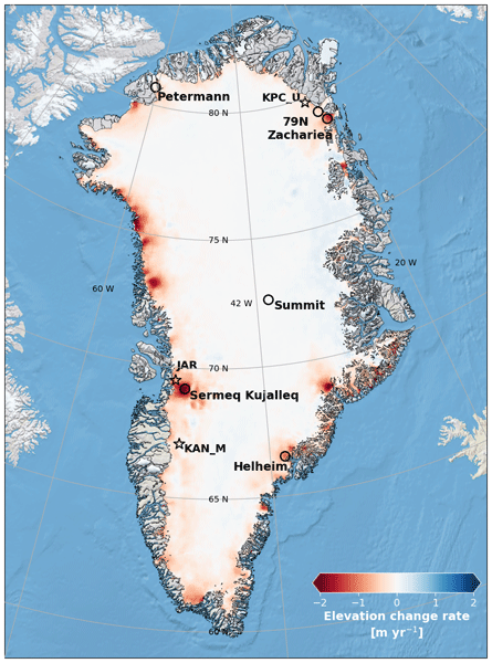
We developed a new statistical approach to track monthly changes in the surface height of the Greenland Ice Sheet using radar data from the CryoSat-2 satellite (2011–2025). The method lets seasonal and long-term variations emerge directly from the data, creating a consistent record of elevation change that helps reveal how Greenland responds to ongoing climate change.
Marion Bocquet, Robert Ricker, Torbjörn Kagel, Stefan Kern, Thomas Lavergne, Emily Down, and Stefan Hendricks
EGUsphere, https://doi.org/10.5194/egusphere-2026-4063, https://doi.org/10.5194/egusphere-2026-4063, 2026
Short summary
Short summary
Antarctic sea ice has changed dramatically in recent years, highlighting the need for better information on ice and snow thickness. We combined measurements from several satellites with ice motion data to create a daily updated record spanning from 2018 to 2025. By considering the ice drift in the sea-ice thickness gridding process, we captured finer spatial detail and produced more consistent estimates. The results provide a stronger basis for monitoring ongoing changes in the Southern Ocean.
Julien Meloche, Melody Sandells, Henning Löwe, Nick Rutter, Ghislain Picard, Richard Essery, Randall K. Scharien, Alexandre Langlois, Matthias Jaggi, Josh King, Peter Toose, Michele Scagliola, Jerome Bouffard, Alessandro Di Bella, and Christian Haas
EGUsphere, https://doi.org/10.5194/egusphere-2026-3615, https://doi.org/10.5194/egusphere-2026-3615, 2026
This preprint is open for discussion and under review for The Cryosphere (TC).
Short summary
Short summary
Sea ice thickness is essential for climate studies. Radar altimetry has provided sea ice thickness measurements, but uncertainty arises from the interaction of the signal with the snow cover. Therefore, modelling the signal interaction with the snow is necessary to improve retrieval. A radar model was used to simulate the radar signal from the snow-covered sea ice. This work paved the way to improved physical algorithms to retrieve snow depth and sea ice thickness for radar altimeter missions.
Xiaojun Ma, Matt King, Jonathan Bamber, Bin Liu, Wenke Sun, and Qiuyu Wang
EGUsphere, https://doi.org/10.5194/egusphere-2026-3461, https://doi.org/10.5194/egusphere-2026-3461, 2026
This preprint is open for discussion and under review for The Cryosphere (TC).
Short summary
Short summary
Satellite records of glacier change are only about two decades long, so short-term climate swings can strongly affect estimated trends. Using satellite gravity data, we show that the largest year-to-year changes in global glacier mass come from the Arctic and are linked to the North Atlantic Oscillation and Pacific Decadal Oscillation. Accounting for these effects makes Alaska’s estimated ice loss about one-third larger, improving interpretation of glacier change and future sea-level rise.
Leyue Tang, Jonathan L. Bamber, Tian Li, and Gang Qiao
Earth Syst. Sci. Data Discuss., https://doi.org/10.5194/essd-2026-414, https://doi.org/10.5194/essd-2026-414, 2026
Preprint under review for ESSD
Short summary
Short summary
Many Antarctic ice shelves are thinning and retreating, threatening future sea-level rise. Surface damage indicates structural weakening, but long-term records are scarce. We created a multi-decadal surface damage record for nine representative Antarctic ice shelves using satellite imagery and deep learning. The dataset shows that Pine Island, Thwaites and Larsen B have experienced the most significant damage changes since 1999, providing valuable insights into ice shelf stability.
Luisa von Albedyll, Robert Ricker, Frank Kauker, Daniel Krogmann, and Stefan Hendricks
EGUsphere, https://doi.org/10.5194/egusphere-2026-3122, https://doi.org/10.5194/egusphere-2026-3122, 2026
Short summary
Short summary
Using satellite observations and model simulations, we studied winter Arctic sea ice thickness change. Separating thickening from ridging and thinning from lead opening showed that dynamic processes contribute nearly as much to winter ice growth as freezing. Between 2002 and 2020, dynamic thickness change increased linked to stronger sea ice deformation. This is consistent with the idea that sea ice dynamics partly counteract thinning of Arctic sea ice during ongoing climate warming.
Gwenael Jestin, Sara Fleury, Matthias Raynal, Marta Alves, Fanny Piras, Anaëlle Treboutte, François Boy, Inès Benabdillah, Louise Yu, and Gérald Dibarboure
EGUsphere, https://doi.org/10.5194/egusphere-2026-2569, https://doi.org/10.5194/egusphere-2026-2569, 2026
This preprint is open for discussion and under review for The Cryosphere (TC).
Short summary
Short summary
With its wide swath of 120 km, the SWOT altimeter offers unrivalled spatial and temporal coverage of the polar oceans. But frozen oceans are difficult to study because the ice cover only reveals the open ocean through cracks and polynyas. Whether studying the ice or the ocean, leads and floes must be distinguished. This classification is now available in the CNES L3 product at a resolution of 250 m. This paper outlines the methodology and improvements of the derived ice concentration maps.
Barbara Jenny, Tim Enzlberger Jensen, and René Forsberg
EGUsphere, https://doi.org/10.5194/egusphere-2026-2451, https://doi.org/10.5194/egusphere-2026-2451, 2026
Short summary
Short summary
Our study shows that satellite measurements can track changes in Greenland’s ice mass every few days, revealing short‑term melt events that monthly products cannot capture. We combine the range acceleration of a gravity mission with surface-height data to improve the spatial distribution of these changes. This approach helps us better understand rapid ice‑loss patterns and should be considered for future satellite missions.
Steven Franke, Daniel Steinhage, Veit Helm, Tobias Binder, Uwe Nixdorf, Heinrich Miller, Angelika Humbert, Daniela Jansen, Graeme Eagles, Hannes Eisermann, Wilfried Jokat, Antonia Ruppel, Reinhard Drews, Alexandra Zuhr, Amelie Driemel, Andreas Walter, Peter Konopatzky, Robin Heß, Antonie Haas, Roland Koppe, Pascal H. Andreas, and Olaf Eisen
The Cryosphere, 20, 2485–2530, https://doi.org/10.5194/tc-20-2485-2026, https://doi.org/10.5194/tc-20-2485-2026, 2026
Short summary
Short summary
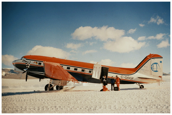
This review synthesizes 30 years of Alfred Wegener Institute’s (AWI) airborne radar research in Antarctica and Greenland, detailing six radar systems and their applications in studying ice dynamics, basal properties, and subglacial landscapes. Moreover, it introduces the public release of AWI's airborne radar datasets via the Radar Data over Polar Ice Sheets Viewer and PANGAEA, ensuring findable, accessible, interoperable, and reusable access for future polar research.
Javed Hassan, Karina Nielsen, William Colgan, Rijan Bhakta Kayastha, Mira Khadka, and Shfaqat Abbas Khan
EGUsphere, https://doi.org/10.5194/egusphere-2026-808, https://doi.org/10.5194/egusphere-2026-808, 2026
Short summary
Short summary
High-altitude lakes in High Mountain Asia (HMA) are important sources of freshwater and sensitive indicators of environmental change. Using satellite data from 2010 to 2024, we examine water level changes in 232 lakes across HMA. Results show rising lake levels on the Tibetan Plateau, while lakes in the Himalaya are declining. These contrasting patterns highlight strong regional differences and provide valuable information for understanding water availability and associated hazards.
Ida Lundtorp Olsen, Henriette Skourup, Heidi Sallila, Stefan Hendricks, Renée Mie Fredensborg Hansen, Stefan Kern, Stephan Paul, Marion Bocquet, Sara Fleury, Dmitry Divine, and Eero Rinne
Earth Syst. Sci. Data, 18, 2469–2505, https://doi.org/10.5194/essd-18-2469-2026, https://doi.org/10.5194/essd-18-2469-2026, 2026
Short summary
Short summary
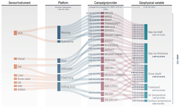
Discover the latest advancements in sea ice research with our comprehensive Climate Change Initiative (CCI) sea ice thickness (SIT) Round Robin Data Package (RRDP). This pioneering collection contains reference measurements from 1960 to 2024 from airborne sensors, buoys, visual observations and sonar and covers the polar regions from 1993 to 2024, providing crucial reference measurements for validating satellite-derived sea ice thickness.
Julien A. Bodart, Vjeran Višnjević, Steven Franke, Veit Helm, Olaf Eisen, Antoine Hermant, Alexandra M. Zuhr, Daniel Steinhage, and Johannes C. R. Sutter
The Cryosphere, 20, 1379–1404, https://doi.org/10.5194/tc-20-1379-2026, https://doi.org/10.5194/tc-20-1379-2026, 2026
Short summary
Short summary
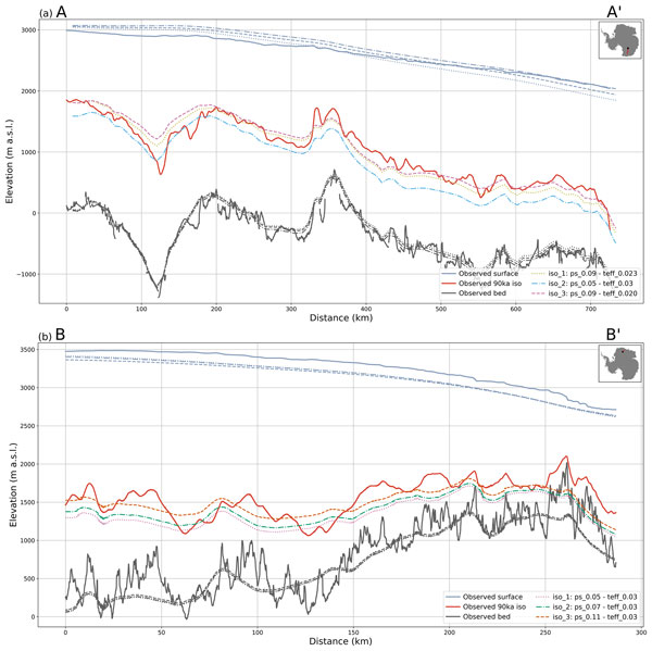
We used radar data and computer models to study layers within Antarctic ice that record past snowfall and ice-sheet changes. These layers, called isochrones, are seldomly used to model Antarctica’s past. By comparing radar observations with simulations, we show how they can greatly improve model accuracy and provide two new datasets to help refine future reconstructions of Antarctic ice evolution.
Nicholas Williams, Nicholas Byrne, Daniel Feltham, Peter Jan Van Leeuwen, Ross Bannister, David Schroeder, Isobel Lawrence, Lars Nerger, Jack Landy, and Geoffrey Dawson
EGUsphere, https://doi.org/10.5194/egusphere-2026-742, https://doi.org/10.5194/egusphere-2026-742, 2026
Short summary
Short summary
In this study we present three satellite era Arctic sea ice reanalyses, each assimilating different combinations of sea ice concentration and thickness observations. Results show that using year-round thickness observations substantially improves reanalysis compared to winter-only data. The best-performing reanalysis reveals a seasonally compensating bias cycle, suggesting errors in ice growth, leads, refreezing, marginal ice zone dynamics, redistribution, and melt timing mask model errors.
Simon Jakob Köhn and Karina Nielsen
EGUsphere, https://doi.org/10.5194/egusphere-2025-6366, https://doi.org/10.5194/egusphere-2025-6366, 2026
Short summary
Short summary
The new Surface Water and Ocean Topography (SWOT) satellite represents a leap in satellite-based observations of surface water elevations. We evaluated SWOT’s ability to measure water levels in Danish lakes larger than 0.25km2. We compared data from the SWOT satellite with in-situ station data from 37 lakes. To ensure valid water levels, we tested six methods for selecting SWOT's data. Furthermore, we show that SWOT Pixel Cloud data contains indications of a time-varying residual roll error.
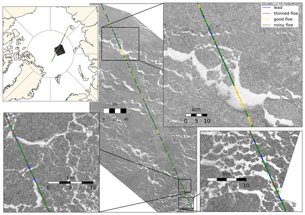
Anne Braakmann-Folgmann, Jack C. Landy, Geoffrey Dawson, and Robert Ricker
The Cryosphere, 20, 905–929, https://doi.org/10.5194/tc-20-905-2026, https://doi.org/10.5194/tc-20-905-2026, 2026
Short summary
Short summary
To calculate sea ice thickness from altimetry, returns from ice and leads need to be differentiated. During summer, melt ponds complicate this task, as they resemble leads. In this study, we improve a previously suggested neural network classifier by expanding the training dataset fivefold, tuning the network architecture and introducing an additional class for thinned floes. We show that this increases the accuracy from 77 ± 5 % to 84 ± 2 % and that more leads are found.
Valentin Ludwig, Caroline Ribere, Sara Fleury, Christian Haas, Michel Tsamados, Mahmoud El Hajj, Jerome Bouffard, Michele Scagliola, Marion Bocquet, Eric de Boisseson, Vincent Boulenger, Guillaume Boutin, Laurence Connor, Léo Edel, Stefan Hendricks, Ferran Hernández Macià, Marcus Huntemann, Lars Kaleschke, Frank Kauker, Jack Landy, Tom Megain, Alek Petty, Till Soya Rasmussen, Mads Hvid Ribergaard, Robert Ricker, Axel Schweiger, Hoyeon Shi, Xiangshan Tian-Kunze, Donghui Yi, and Alessandro Di Bella
EGUsphere, https://doi.org/10.5194/egusphere-2025-6201, https://doi.org/10.5194/egusphere-2025-6201, 2026
Short summary
Short summary
Our paper compares Arctic sea-ice thickness datasets from models, reanalyses, satellite-only, and multi-product sources. We validate them against Beaufort Sea reference data, compare large-scale products, and analyse time series. Cross-product biases range from 0.2–0.4 m, RMSDs from 0.4–0.9 m, and correlations from 0.5–0.8. We find no 2010–2023 trend, but 1995–2023 thinning of ~ 0.5 m in November and ~ 0.3 m in March.
Polona Itkin, Evgenii Salganik, Dmitry V. Divine, Arttu Jutila, Christian Katlein, Mara Neudert, Ian A. Raphael, and Robert Ricker
EGUsphere, https://doi.org/10.5194/egusphere-2025-6081, https://doi.org/10.5194/egusphere-2025-6081, 2025
Short summary
Short summary
We studied how Arctic ice ridges grow and change through winter and spring using a sensor that measures ice thickness without drilling. By comparing these measurements with data from aircraft, underwater surveys, and field work, we show that the sensor can detect both the full ridge thickness and its solid inner core. Our results reveal slow winter strengthening of ridges and highlight this method's value for understanding ice conditions and ecosystems.
Maria T. Kappelsberger, Johan Nilsson, Martin Horwath, Veit Helm, and Alex S. Gardner
EGUsphere, https://doi.org/10.5194/egusphere-2025-5745, https://doi.org/10.5194/egusphere-2025-5745, 2025
Short summary
Short summary
We compare surface elevation changes of the Antarctic Ice Sheet interior as derived from satellite radar altimetry and laser altimetry between 2019 and 2024. Both methods indicate an increase in surface elevation across most of the study area, coinciding with an episode of excess snow accumulation as modelled. However, rates of surface elevation increase from radar altimetry are systematically lower than those from laser altimetry.
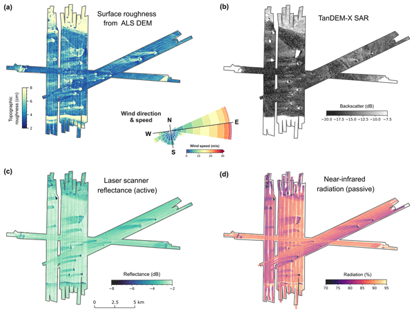
Steven Franke, Mara Neudert, Veit Helm, Arttu Jutila, Océane Hames, Niklas Neckel, Stefanie Arndt, and Christian Haas
The Cryosphere, 19, 6319–6339, https://doi.org/10.5194/tc-19-6319-2025, https://doi.org/10.5194/tc-19-6319-2025, 2025
Short summary
Short summary
Our research explored how icebergs affect the distribution of snow and flooding on Antarctic coastal sea ice. Using aircraft-based radar and laser scanning, we found that icebergs create thick snow drifts on their wind-facing sides and leave snow-free zones in their lee. The weight of these snow drifts often causes the ice below to flood, forming slush. These patterns, driven by wind and iceberg placement, are crucial for understanding sea ice changes and improving climate models.
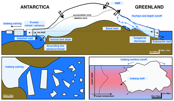
Gavin A. Schmidt, Kenneth D. Mankoff, Jonathan L. Bamber, Clara Burgard, Dustin Carroll, David M. Chandler, Violaine Coulon, Benjamin J. Davison, Matthew H. England, Paul R. Holland, Nicolas C. Jourdain, Qian Li, Juliana M. Marson, Pierre Mathiot, Clive R. McMahon, Twila A. Moon, Ruth Mottram, Sophie Nowicki, Anna Olivé Abelló, Andrew G. Pauling, Thomas Rackow, and Damien Ringeisen
Geosci. Model Dev., 18, 8333–8361, https://doi.org/10.5194/gmd-18-8333-2025, https://doi.org/10.5194/gmd-18-8333-2025, 2025
Short summary
Short summary
The impact of increasing mass loss from the Greenland and Antarctic ice sheets has not so far been included in historical climate model simulations. This paper describes the protocols and data available for modeling groups to add this anomalous freshwater to their ocean modules to better represent the impacts of these fluxes on ocean circulation, sea ice, salinity and sea level.
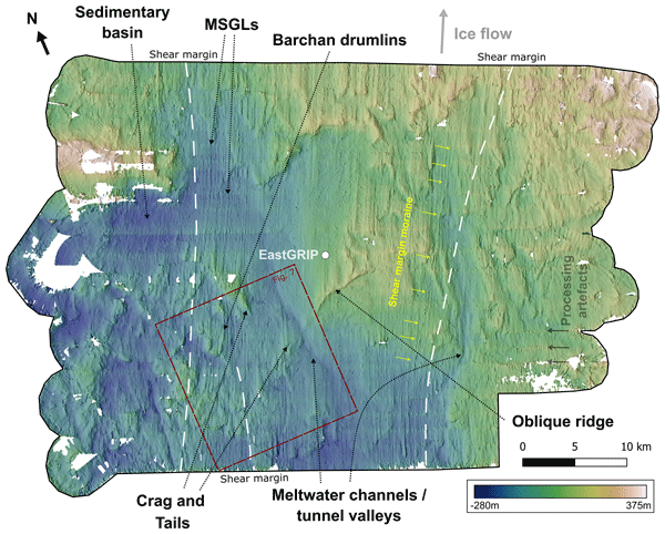
Charlotte M. Carter, Steven Franke, Daniela Jansen, Chris R. Stokes, Veit Helm, John Paden, and Olaf Eisen
The Cryosphere, 19, 5299–5315, https://doi.org/10.5194/tc-19-5299-2025, https://doi.org/10.5194/tc-19-5299-2025, 2025
Short summary
Short summary
The subglacial landforms beneath actively fast-flowing ice in Greenland have not been explored in detail, as digital elevation models have not had a high enough resolution to see these features. We use swath radar imaging to visualise landforms at the onset of an ice stream, revealing mega-scale glacial lineations, that would usually be assumed to be indicative of faster ice flow than the current velocities. Interpretation of the landscape also gives an indication of the properties of the bed.
Marcello Passaro
Ocean Sci., 21, 2663–2679, https://doi.org/10.5194/os-21-2663-2025, https://doi.org/10.5194/os-21-2663-2025, 2025
Short summary
Short summary
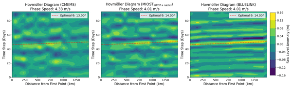
This paper evaluates the capability of satellite altimetry to monitor coastally trapped waves in light of the latest advancements in daily gridded sea level data, including new interpolation schemes, an increased number of missions in orbit, and the incorporation of wide-swath altimetry measurements. The eastern Australian coast serves as a testbed, with validation provided by tide gauges and model data.
Christian T. Wild, Reinhard Drews, Niklas Neckel, Joohan Lee, Sihyung Kim, Hyangsun Han, Won Sang Lee, Veit Helm, Sebastian Harry Reid Rosier, Oliver J. Marsh, and Wolfgang Rack
The Cryosphere, 19, 4533–4554, https://doi.org/10.5194/tc-19-4533-2025, https://doi.org/10.5194/tc-19-4533-2025, 2025
Short summary
Short summary
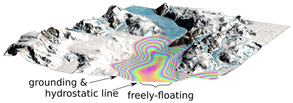
The stability of the Antarctic Ice Sheet depends on how resistance along the sides of large glaciers slows down the flow of ice into the ocean. We present a method to map ice strength using the effect of ocean tides on floating ice shelves. Incorporating weaker ice in shear zones improves the accuracy of model predictions, compared with satellite observations. This demonstrates the untapped potential of radar satellites to map ice stiffness in the most critical areas for ice sheet stability.
Renée Mie Fredensborg Hansen, Henriette Skourup, Eero Rinne, Arttu Jutila, Isobel R. Lawrence, Andrew Shepherd, Knut Vilhelm Høyland, Jilu Li, Fernando Rodriguez-Morales, Sebastian Bjerregaaard Simonsen, Jeremy Wilkinson, Gaelle Veyssiere, Donghui Yi, René Forsberg, and Taniâ Gil Duarte Casal
The Cryosphere, 19, 4193–4209, https://doi.org/10.5194/tc-19-4193-2025, https://doi.org/10.5194/tc-19-4193-2025, 2025
Short summary
Short summary
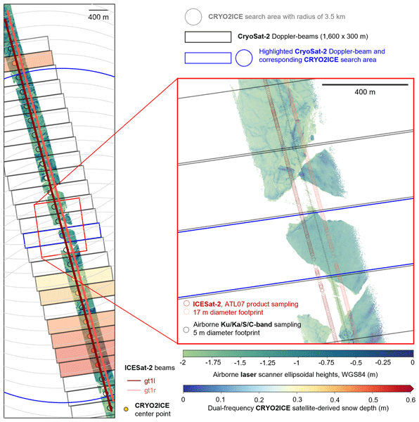
An airborne campaign collected unprecedented coincident multi-frequency radar and lidar data over sea ice along a CryoSat-2 and ICESat-2 (CRYO2ICE) orbit in the Weddell Sea, useful for evaluating microwave snow penetration. Ka-band and Ku-band had limited penetration with significant contributions from the air–snow interface, contradicting traditional assumptions with discrepancies between commonly used C/S-band "snow-radar" methodologies, all challenging comparisons of airborne and spaceborne estimates.
Renée Mie Fredensborg Hansen, Henriette Skourup, Eero Rinne, Arttu Jutila, Isobel R. Lawrence, Andrew Shepherd, Knut Vilhelm Høyland, Jilu Li, Fernando Rodriguez-Morales, Sebastian Bjerregaaard Simonsen, Jeremy Wilkinson, Gaelle Veyssiere, Donghui Yi, René Forsberg, and Taniâ Gil Duarte Casal
The Cryosphere, 19, 4167–4192, https://doi.org/10.5194/tc-19-4167-2025, https://doi.org/10.5194/tc-19-4167-2025, 2025
Short summary
Short summary
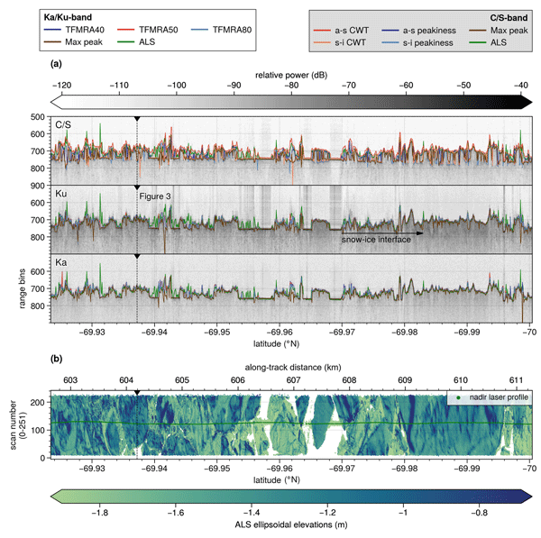
An airborne campaign collected unprecedented coincident multi-frequency radar and lidar data over sea ice along a CryoSat-2 and ICESat-2 (CRYO2ICE) orbit in the Weddell Sea, useful for evaluating microwave snow penetration. Ka-band and Ku-band had limited penetration with significant contributions from the air–snow interface, contradicting traditional assumptions with discrepancies between commonly used C/S-band "snow-radar" methodologies, all challenging comparisons of airborne and spaceborne estimates.
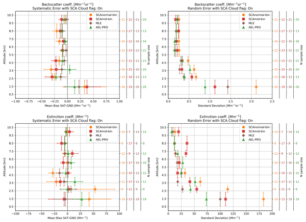
Peristera Paschou, Nikolaos Siomos, Eleni Marinou, Antonis Gkikas, Samira M. Idrissa, Daniel T. Quaye, Désiré D. Fiogbe Attannon, Kalliopi Artemis Voudouri, Charikleia Meleti, David P. Donovan, George Georgoussis, Tommaso Parrinello, Thorsten Fehr, Jonas von Bismarck, and Vassilis Amiridis
Atmos. Meas. Tech., 18, 4731–4754, https://doi.org/10.5194/amt-18-4731-2025, https://doi.org/10.5194/amt-18-4731-2025, 2025
Short summary
Short summary
This study presents the results from a validation study on the Level 2A products (aerosol optical properties) of the ESA's (European Space Agency) Aeolus mission. Measurements from the eVe lidar, a combined linear/circular polarization and Raman lidar and ESA's ground reference system, that have been collected during the Joint Aeolus Tropical Atlantic Campaign are compared with collocated Aeolus Level 2A profiles obtained from the latest version (Baseline 16) of the Aeolus algorithms.
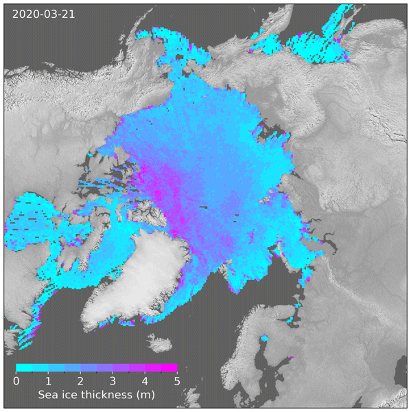
Robert Ricker, Thomas Lavergne, Stefan Hendricks, Stephan Paul, Emily Down, Mari Anne Killie, and Marion Bocquet
The Cryosphere, 19, 3785–3803, https://doi.org/10.5194/tc-19-3785-2025, https://doi.org/10.5194/tc-19-3785-2025, 2025
Short summary
Short summary
We developed a new method to map Arctic sea ice thickness daily using satellite measurements. We address a problem similar to motion blur in photography. Traditional methods collect satellite data over 1 month to get a full picture of Arctic sea ice thickness. But in the same way as in photos of moving objects, long exposure leads to motion blur, making it difficult to identify certain features in the sea ice maps. Our method corrects for this motion blur, providing a sharper view of the evolving sea ice.
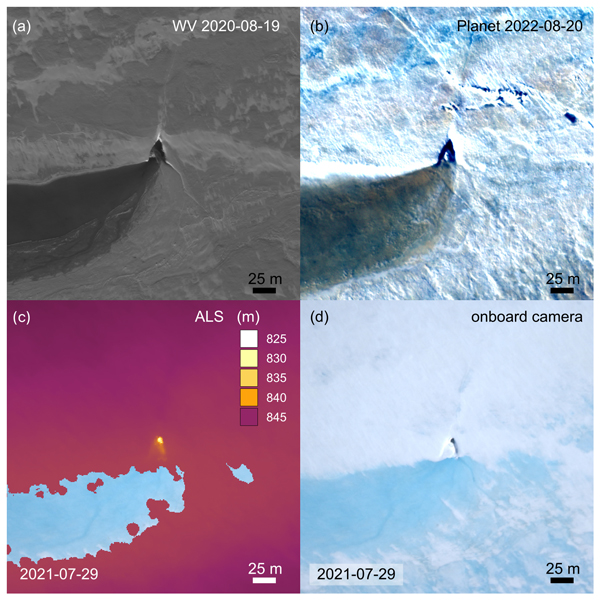
Angelika Humbert, Veit Helm, Ole Zeising, Niklas Neckel, Matthias H. Braun, Shfaqat Abbas Khan, Martin Rückamp, Holger Steeb, Julia Sohn, Matthias Bohnen, and Ralf Müller
The Cryosphere, 19, 3009–3032, https://doi.org/10.5194/tc-19-3009-2025, https://doi.org/10.5194/tc-19-3009-2025, 2025
Short summary
Short summary
We study the evolution of a massive lake on the Greenland Ice Sheet using satellite and airborne data and some modelling. The lake is emptying rapidly. Water flows to the glacier's base through cracks and triangular-shaped moulins that remain visible over the years. Some of them become reactivated. We find features inside the glacier that stem from drainage events with a width of even 1 km. These features are persistent over the years, although they are changing in shape.
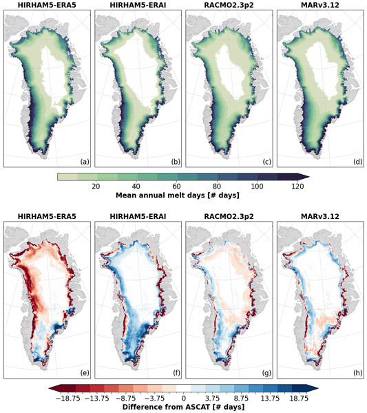
Anna Puggaard, Nicolaj Hansen, Ruth Mottram, Thomas Nagler, Stefan Scheiblauer, Sebastian B. Simonsen, Louise S. Sørensen, Jan Wuite, and Anne M. Solgaard
The Cryosphere, 19, 2963–2981, https://doi.org/10.5194/tc-19-2963-2025, https://doi.org/10.5194/tc-19-2963-2025, 2025
Short summary
Short summary
Regional climate models are currently the only source for assessing the melt volume of the Greenland Ice Sheet on a global scale. This study compares the modeled melt volume with observations from weather stations and melt extent observed from the Advanced SCATterometer (ASCAT) to assess the performance of the models. It highlights the importance of critically evaluating model outputs with high-quality satellite measurements to improve the understanding of variability among models.
Lena Happ, Sonali Patil, Stefan Hendricks, Riccardo Fellegara, Lars Kaleschke, and Andreas Gerndt
ISPRS Ann. Photogramm. Remote Sens. Spatial Inf. Sci., X-G-2025, 333–340, https://doi.org/10.5194/isprs-annals-X-G-2025-333-2025, https://doi.org/10.5194/isprs-annals-X-G-2025-333-2025, 2025
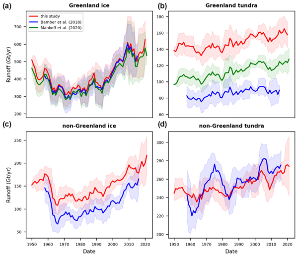
Adam Igneczi and Jonathan Louis Bamber
Earth Syst. Sci. Data, 17, 3203–3218, https://doi.org/10.5194/essd-17-3203-2025, https://doi.org/10.5194/essd-17-3203-2025, 2025
Short summary
Short summary
Freshwater from Arctic land ice loss strongly affects the Arctic and North Atlantic oceans. Datasets describing this freshwater discharge have low resolution and do not cover the entire Arctic. We statistically enhanced coarse-resolution climate model data – from approximately 6 km to 250 m – and routed meltwater towards the coastlines to provide high-resolution data covering all Arctic regions. This approach has far fewer computational requirements than running climate models at high resolution.
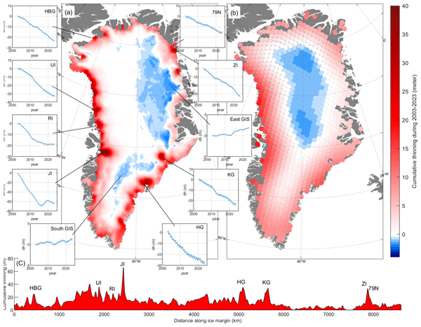
Shfaqat A. Khan, Helene Seroussi, Mathieu Morlighem, William Colgan, Veit Helm, Gong Cheng, Danjal Berg, Valentina R. Barletta, Nicolaj K. Larsen, William Kochtitzky, Michiel van den Broeke, Kurt H. Kjær, Andy Aschwanden, Brice Noël, Jason E. Box, Joseph A. MacGregor, Robert S. Fausto, Kenneth D. Mankoff, Ian M. Howat, Kuba Oniszk, Dominik Fahrner, Anja Løkkegaard, Eigil Y. H. Lippert, Alicia Bråtner, and Javed Hassan
Earth Syst. Sci. Data, 17, 3047–3071, https://doi.org/10.5194/essd-17-3047-2025, https://doi.org/10.5194/essd-17-3047-2025, 2025
Short summary
Short summary
The surface elevation of the Greenland Ice Sheet is changing due to surface mass balance processes and ice dynamics, each exhibiting distinct spatiotemporal patterns. Here, we employ satellite and airborne altimetry data with fine spatial (1 km) and temporal (monthly) resolutions to document this spatiotemporal evolution from 2003 to 2023. This dataset of fine-resolution altimetry data in both space and time will support studies of ice mass loss and be useful for GIS ice sheet modeling.
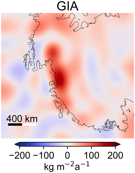
Matthias O. Willen, Bert Wouters, Taco Broerse, Eric Buchta, and Veit Helm
The Cryosphere, 19, 2213–2227, https://doi.org/10.5194/tc-19-2213-2025, https://doi.org/10.5194/tc-19-2213-2025, 2025
Short summary
Short summary
Collapse of the West Antarctic Ice Sheet in the Amundsen Sea Embayment is likely in the near future. Vertical uplift of bedrock due to glacial isostatic adjustment stabilizes the ice sheet and may delay its collapse. So far, only spatially and temporally sparse GPS measurements have been able to observe this bedrock motion. We have combined satellite data and quantified a region-wide bedrock motion that independently matches GPS measurements. This can improve ice sheet predictions.
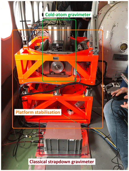
Tim Enzlberger Jensen, Bjørnar Dale, Andreas Stokholm, René Forsberg, Alexandre Bresson, Nassim Zahzam, Alexis Bonnin, and Yannick Bidel
Earth Syst. Sci. Data, 17, 1667–1684, https://doi.org/10.5194/essd-17-1667-2025, https://doi.org/10.5194/essd-17-1667-2025, 2025
Short summary
Short summary
The availability of data from two airborne gravity campaigns using sensors based on both classical and quantum technology is presented. Data are made available by the European Space Agency as raw, intermediate, and final data products. Here “raw” refers to the sensor output, while “final” refers to the along-track gravity estimates. This makes the data relevant for users interested in applications ranging from data processing and quantum studies to geophysical studies using gravity observations.
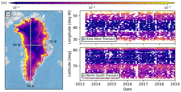
Kirk M. Scanlan, Anja Rutishauser, and Sebastian B. Simonsen
The Cryosphere, 19, 1221–1239, https://doi.org/10.5194/tc-19-1221-2025, https://doi.org/10.5194/tc-19-1221-2025, 2025
Short summary
Short summary
An ice sheet's surface modulates its response to climate change, and it is therefore critical to monitor how it evolves through time. Here, we investigate novel measurements of Greenland surface roughness based on the strength of reflected local airborne and pan-Greenland satellite radar signals. These measurements respond to roughness at scales typically larger than those considered in mass balance modelling while highlighting the scale dependency of surface roughness that is often overlooked.
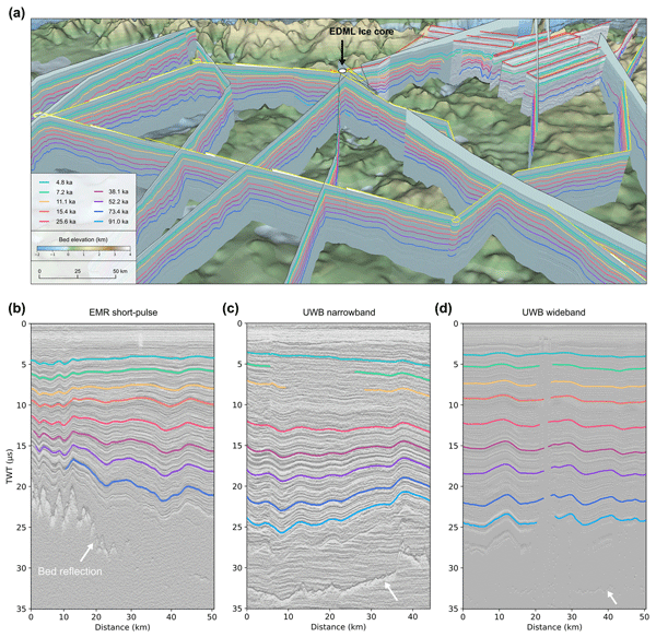
Steven Franke, Daniel Steinhage, Veit Helm, Alexandra M. Zuhr, Julien A. Bodart, Olaf Eisen, and Paul Bons
The Cryosphere, 19, 1153–1180, https://doi.org/10.5194/tc-19-1153-2025, https://doi.org/10.5194/tc-19-1153-2025, 2025
Short summary
Short summary
The study presents internal reflection horizons (IRHs) over an area of 450 000 km² from western Dronning Maud Land, Antarctica, spanning 4.8–91 ka. Using radar and ice core data, nine IRHs were dated and correlated with volcanic events. The data enhance our understanding of the ice sheet's age–depth architecture, accumulation, and dynamics. The findings inform ice flow models and contribute to Antarctic-wide comparisons of IRHs, supporting efforts toward a 3D age–depth ice sheet model.
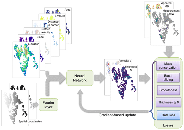
Viola Steidl, Jonathan Louis Bamber, and Xiao Xiang Zhu
The Cryosphere, 19, 645–661, https://doi.org/10.5194/tc-19-645-2025, https://doi.org/10.5194/tc-19-645-2025, 2025
Short summary
Short summary
Glacier ice thickness is difficult to measure directly but is essential for glacier evolution modelling. In this work, we employ a novel approach combining physical knowledge and data-driven machine learning to estimate the ice thickness of multiple glaciers in Spitsbergen, Barentsøya, and Edgeøya in Svalbard. We identify challenges for the physics-aware machine learning model and opportunities for improving the accuracy and physical consistency that would also apply to other geophysical tasks.
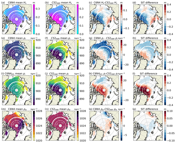
Imke Sievers, Henriette Skourup, and Till A. S. Rasmussen
The Cryosphere, 18, 5985–6004, https://doi.org/10.5194/tc-18-5985-2024, https://doi.org/10.5194/tc-18-5985-2024, 2024
Short summary
Short summary
To derive sea ice thickness (SIT) from satellite freeboard (FB) observations, assumptions about snow thickness, snow density, sea ice density and water density are needed. These parameters are impossible to observe alongside FB, so many existing products use empirical values. In this study, modeled values are used instead. The modeled values and otherwise commonly used empirical values are evaluated against in situ observations. In a further analysis, the influence on SIT is quantified.
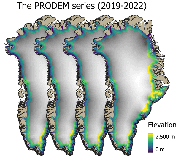
Mai Winstrup, Heidi Ranndal, Signe Hillerup Larsen, Sebastian B. Simonsen, Kenneth D. Mankoff, Robert S. Fausto, and Louise Sandberg Sørensen
Earth Syst. Sci. Data, 16, 5405–5428, https://doi.org/10.5194/essd-16-5405-2024, https://doi.org/10.5194/essd-16-5405-2024, 2024
Short summary
Short summary
Surface topography across the marginal zone of the Greenland Ice Sheet is constantly evolving. Here we present an annual series (2019–2022) of summer digital elevation models (PRODEMs) for the Greenland Ice Sheet margin, covering all outlet glaciers from the ice sheet. The PRODEMs are based on fusion of CryoSat-2 radar altimetry and ICESat-2 laser altimetry. With their high spatial and temporal resolution, the PRODEMs will enable detailed studies of the changes in marginal ice sheet elevations.
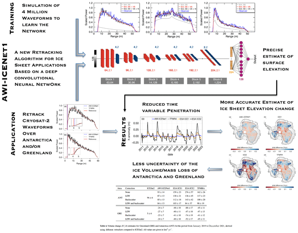
Veit Helm, Alireza Dehghanpour, Ronny Hänsch, Erik Loebel, Martin Horwath, and Angelika Humbert
The Cryosphere, 18, 3933–3970, https://doi.org/10.5194/tc-18-3933-2024, https://doi.org/10.5194/tc-18-3933-2024, 2024
Short summary
Short summary
We present a new approach (AWI-ICENet1), based on a deep convolutional neural network, for analysing satellite radar altimeter measurements to accurately determine the surface height of ice sheets. Surface height estimates obtained with AWI-ICENet1 (along with related products, such as ice sheet height change and volume change) show improved and unbiased results compared to other products. This is important for the long-term monitoring of ice sheet mass loss and its impact on sea level rise.
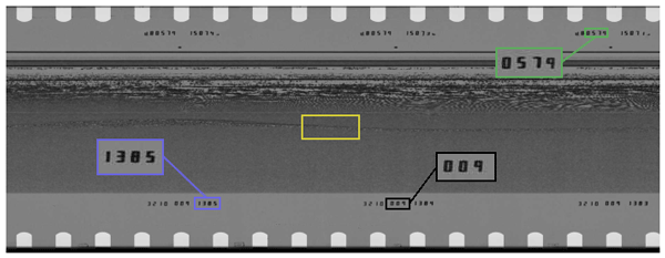
Nanna B. Karlsson, Dustin M. Schroeder, Louise Sandberg Sørensen, Winnie Chu, Jørgen Dall, Natalia H. Andersen, Reese Dobson, Emma J. Mackie, Simon J. Köhn, Jillian E. Steinmetz, Angelo S. Tarzona, Thomas O. Teisberg, and Niels Skou
Earth Syst. Sci. Data, 16, 3333–3344, https://doi.org/10.5194/essd-16-3333-2024, https://doi.org/10.5194/essd-16-3333-2024, 2024
Short summary
Short summary
In the 1970s, more than 177 000 km of observations were acquired from airborne radar over the Greenland ice sheet. The radar data contain information on not only the thickness of the ice, but also the properties of the ice itself. This information was recorded on film rolls and subsequently stored. In this study, we document the digitization of these film rolls that shed new and unprecedented detailed light on the Greenland ice sheet 50 years ago.
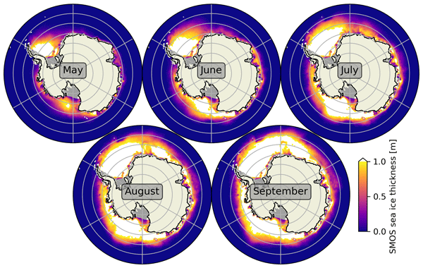
Lars Kaleschke, Xiangshan Tian-Kunze, Stefan Hendricks, and Robert Ricker
Earth Syst. Sci. Data, 16, 3149–3170, https://doi.org/10.5194/essd-16-3149-2024, https://doi.org/10.5194/essd-16-3149-2024, 2024
Short summary
Short summary
We describe a sea ice thickness dataset based on SMOS satellite measurements, initially designed for the Arctic but adapted for Antarctica. We validated it using limited Antarctic measurements. Our findings show promising results, with a small difference in thickness estimation and a strong correlation with validation data within the valid thickness range. However, improvements and synergies with other sensors are needed, especially for sea ice thicker than 1 m.
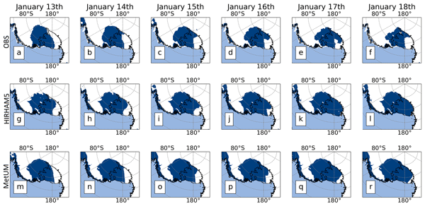
Nicolaj Hansen, Andrew Orr, Xun Zou, Fredrik Boberg, Thomas J. Bracegirdle, Ella Gilbert, Peter L. Langen, Matthew A. Lazzara, Ruth Mottram, Tony Phillips, Ruth Price, Sebastian B. Simonsen, and Stuart Webster
The Cryosphere, 18, 2897–2916, https://doi.org/10.5194/tc-18-2897-2024, https://doi.org/10.5194/tc-18-2897-2024, 2024
Short summary
Short summary
We investigated a melt event over the Ross Ice Shelf. We use regional climate models and a firn model to simulate the melt and compare the results with satellite data. We find that the firn model aligned well with observed melt days in certain parts of the ice shelf. The firn model had challenges accurately simulating the melt extent in the western sector. We identified potential reasons for these discrepancies, pointing to limitations in the models related to representing the cloud properties.
Julien Meloche, Melody Sandells, Henning Löwe, Nick Rutter, Richard Essery, Ghislain Picard, Randall K. Scharien, Alexandre Langlois, Matthias Jaggi, Josh King, Peter Toose, Jérôme Bouffard, Alessandro Di Bella, and Michele Scagliola
EGUsphere, https://doi.org/10.5194/egusphere-2024-1583, https://doi.org/10.5194/egusphere-2024-1583, 2024
Preprint archived
Short summary
Short summary
Sea ice thickness is essential for climate studies. Radar altimetry has provided sea ice thickness measurement, but uncertainty arises from interaction of the signal with the snow cover. Therefore, modelling the signal interaction with the snow is necessary to improve retrieval. A radar model was used to simulate the radar signal from the snow-covered sea ice. This work paved the way to improved physical algorithm to retrieve snow depth and sea ice thickness for radar altimeter missions.
Jérôme Benveniste, Salvatore Dinardo, Luciana Fenoglio-Marc, Christopher Buchhaupt, Michele Scagliola, Marcello Passaro, Karina Nielsen, Marco Restano, Américo Ambrózio, Giovanni Sabatino, Carla Orrù, and Beniamino Abis
Proc. IAHS, 385, 457–463, https://doi.org/10.5194/piahs-385-457-2024, https://doi.org/10.5194/piahs-385-457-2024, 2024
Short summary
Short summary
This paper presents the RDSAR, SAR/SARin & FF-SAR altimetry processors available in the ESA Altimetry Virtual Lab (AVL) hosted on the EarthConsole® platform. An overview on processors and features as well as preliminary analyses using AVL output data are reported to demonstrate the quality of the ESA Altimetry Virtual Lab altimetry services in providing innovative solutions to the radar altimetry community. https://earthconsole.eu//
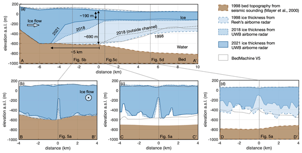
Ole Zeising, Niklas Neckel, Nils Dörr, Veit Helm, Daniel Steinhage, Ralph Timmermann, and Angelika Humbert
The Cryosphere, 18, 1333–1357, https://doi.org/10.5194/tc-18-1333-2024, https://doi.org/10.5194/tc-18-1333-2024, 2024
Short summary
Short summary
The 79° North Glacier in Greenland has experienced significant changes over the last decades. Due to extreme melt rates, the ice has thinned significantly in the vicinity of the grounding line, where a large subglacial channel has formed since 2010. We attribute these changes to warm ocean currents and increased subglacial discharge from surface melt. However, basal melting has decreased since 2018, indicating colder water inflow into the cavity below the glacier.
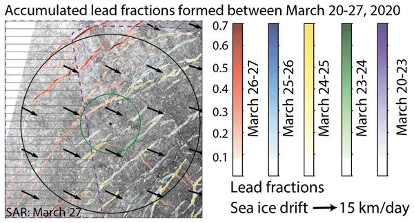
Luisa von Albedyll, Stefan Hendricks, Nils Hutter, Dmitrii Murashkin, Lars Kaleschke, Sascha Willmes, Linda Thielke, Xiangshan Tian-Kunze, Gunnar Spreen, and Christian Haas
The Cryosphere, 18, 1259–1285, https://doi.org/10.5194/tc-18-1259-2024, https://doi.org/10.5194/tc-18-1259-2024, 2024
Short summary
Short summary
Leads (openings in sea ice cover) are created by sea ice dynamics. Because they are important for many processes in the Arctic winter climate, we aim to detect them with satellites. We present two new techniques to detect lead widths of a few hundred meters at high spatial resolution (700 m) and independent of clouds or sun illumination. We use the MOSAiC drift 2019–2020 in the Arctic for our case study and compare our new products to other existing lead products.
Matthias O. Willen, Martin Horwath, Eric Buchta, Mirko Scheinert, Veit Helm, Bernd Uebbing, and Jürgen Kusche
The Cryosphere, 18, 775–790, https://doi.org/10.5194/tc-18-775-2024, https://doi.org/10.5194/tc-18-775-2024, 2024
Short summary
Short summary
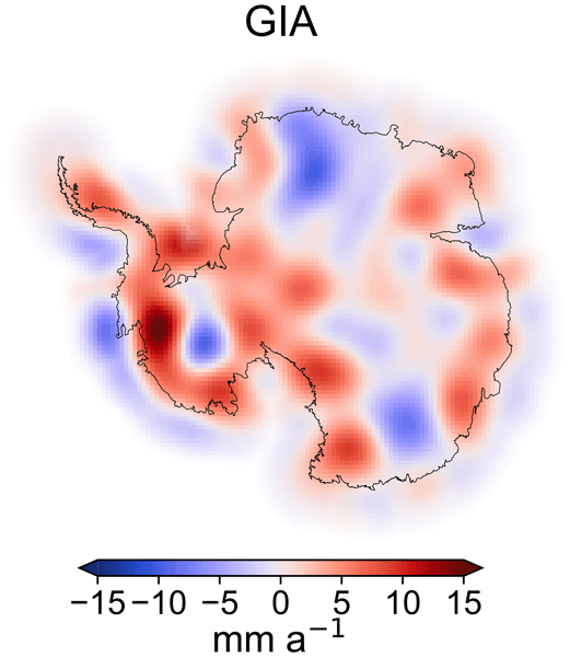
Shrinkage of the Antarctic ice sheet (AIS) leads to sea level rise. Satellite gravimetry measures AIS mass changes. We apply a new method that overcomes two limitations: low spatial resolution and large uncertainties due to the Earth's interior mass changes. To do so, we additionally include data from satellite altimetry and climate and firn modelling, which are evaluated in a globally consistent way with thoroughly characterized errors. The results are in better agreement with independent data.
Tian Li, Konrad Heidler, Lichao Mou, Ádám Ignéczi, Xiao Xiang Zhu, and Jonathan L. Bamber
Earth Syst. Sci. Data, 16, 919–939, https://doi.org/10.5194/essd-16-919-2024, https://doi.org/10.5194/essd-16-919-2024, 2024
Short summary
Short summary
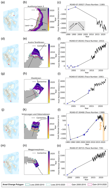
Our study uses deep learning to produce a new high-resolution calving front dataset for 149 marine-terminating glaciers in Svalbard from 1985 to 2023, containing 124 919 terminus traces. This dataset offers insights into understanding calving mechanisms and can help improve glacier frontal ablation estimates as a component of the integrated mass balance assessment.
Laura Melling, Amber Leeson, Malcolm McMillan, Jennifer Maddalena, Jade Bowling, Emily Glen, Louise Sandberg Sørensen, Mai Winstrup, and Rasmus Lørup Arildsen
The Cryosphere, 18, 543–558, https://doi.org/10.5194/tc-18-543-2024, https://doi.org/10.5194/tc-18-543-2024, 2024
Short summary
Short summary
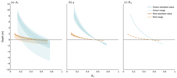
Lakes on glaciers hold large volumes of water which can drain through the ice, influencing estimates of sea level rise. To estimate water volume, we must calculate lake depth. We assessed the accuracy of three satellite-based depth detection methods on a study area in western Greenland and considered the implications for quantifying the volume of water within lakes. We found that the most popular method of detecting depth on the ice sheet scale has higher uncertainty than previously assumed.
Louise Sandberg Sørensen, Rasmus Bahbah, Sebastian B. Simonsen, Natalia Havelund Andersen, Jade Bowling, Noel Gourmelen, Alex Horton, Nanna B. Karlsson, Amber Leeson, Jennifer Maddalena, Malcolm McMillan, Anne Solgaard, and Birgit Wessel
The Cryosphere, 18, 505–523, https://doi.org/10.5194/tc-18-505-2024, https://doi.org/10.5194/tc-18-505-2024, 2024
Short summary
Short summary
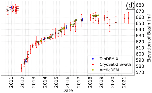
Under the right topographic and hydrological conditions, lakes may form beneath the large ice sheets. Some of these subglacial lakes are active, meaning that they periodically drain and refill. When a subglacial lake drains rapidly, it may cause the ice surface above to collapse, and here we investigate how to improve the monitoring of active subglacial lakes in Greenland by monitoring how their associated collapse basins change over time.
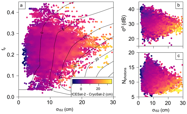
Geoffrey J. Dawson and Jack C. Landy
The Cryosphere, 17, 4165–4178, https://doi.org/10.5194/tc-17-4165-2023, https://doi.org/10.5194/tc-17-4165-2023, 2023
Short summary
Short summary
In this study, we compared measurements from CryoSat-2 and ICESat-2 over Arctic summer sea ice to understand any possible biases between the two satellites. We found that there is a difference when we measure elevation over summer sea ice using CryoSat-2 and ICESat-2, and this is likely due to surface melt ponds. The differences we found were in good agreement with theoretical predictions, and this work will be valuable for summer sea ice thickness measurements from both altimeters.
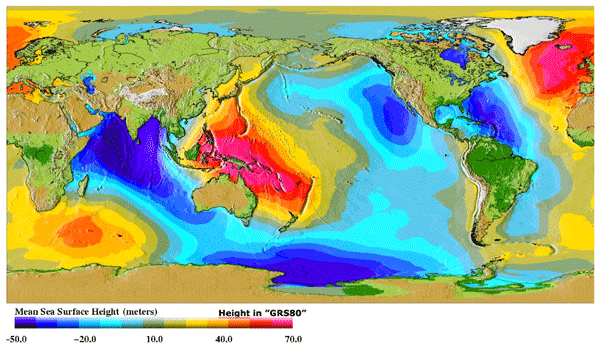
Ole Baltazar Andersen, Stine Kildegaard Rose, Adili Abulaitijiang, Shengjun Zhang, and Sara Fleury
Earth Syst. Sci. Data, 15, 4065–4075, https://doi.org/10.5194/essd-15-4065-2023, https://doi.org/10.5194/essd-15-4065-2023, 2023
Short summary
Short summary
The mean sea surface (MSS) is an important reference for mapping sea-level changes across the global oceans. It is widely used by space agencies in the definition of sea-level anomalies as mapped by satellite altimetry from space. Here a new fully global high-resolution mean sea surface called DTU21MSS is presented, and a suite of evaluations are performed to demonstrate its performance.
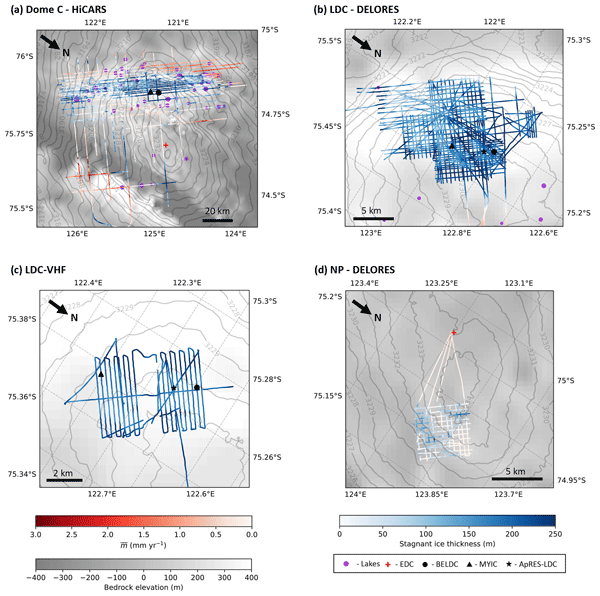
Ailsa Chung, Frédéric Parrenin, Daniel Steinhage, Robert Mulvaney, Carlos Martín, Marie G. P. Cavitte, David A. Lilien, Veit Helm, Drew Taylor, Prasad Gogineni, Catherine Ritz, Massimo Frezzotti, Charles O'Neill, Heinrich Miller, Dorthe Dahl-Jensen, and Olaf Eisen
The Cryosphere, 17, 3461–3483, https://doi.org/10.5194/tc-17-3461-2023, https://doi.org/10.5194/tc-17-3461-2023, 2023
Short summary
Short summary
We combined a numerical model with radar measurements in order to determine the age of ice in the Dome C region of Antarctica. Our results show that at the current ice core drilling sites on Little Dome C, the maximum age of the ice is almost 1.5 Ma. We also highlight a new potential drill site called North Patch with ice up to 2 Ma. Finally, we explore the nature of a stagnant ice layer at the base of the ice sheet which has been independently observed and modelled but is not well understood.
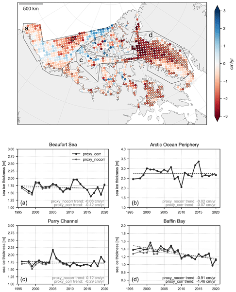
Isolde A. Glissenaar, Jack C. Landy, David G. Babb, Geoffrey J. Dawson, and Stephen E. L. Howell
The Cryosphere, 17, 3269–3289, https://doi.org/10.5194/tc-17-3269-2023, https://doi.org/10.5194/tc-17-3269-2023, 2023
Short summary
Short summary
Observations of large-scale ice thickness have unfortunately only been available since 2003, a short record for researching trends and variability. We generated a proxy for sea ice thickness in the Canadian Arctic for 1996–2020. This is the longest available record for large-scale sea ice thickness available to date and the first record reliably covering the channels between the islands in northern Canada. The product shows that sea ice has thinned by 21 cm over the 25-year record in April.
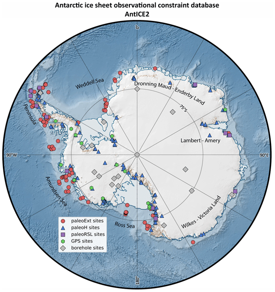
Benoit S. Lecavalier, Lev Tarasov, Greg Balco, Perry Spector, Claus-Dieter Hillenbrand, Christo Buizert, Catherine Ritz, Marion Leduc-Leballeur, Robert Mulvaney, Pippa L. Whitehouse, Michael J. Bentley, and Jonathan Bamber
Earth Syst. Sci. Data, 15, 3573–3596, https://doi.org/10.5194/essd-15-3573-2023, https://doi.org/10.5194/essd-15-3573-2023, 2023
Short summary
Short summary
The Antarctic Ice Sheet Evolution constraint database version 2 (AntICE2) consists of a large variety of observations that constrain the evolution of the Antarctic Ice Sheet over the last glacial cycle. This includes observations of past ice sheet extent, past ice thickness, past relative sea level, borehole temperature profiles, and present-day bedrock displacement rates. The database is intended to improve our understanding of past Antarctic changes and for ice sheet model calibrations.
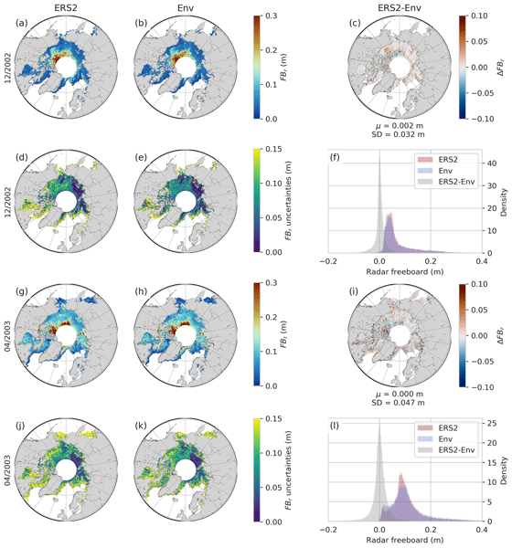
Marion Bocquet, Sara Fleury, Fanny Piras, Eero Rinne, Heidi Sallila, Florent Garnier, and Frédérique Rémy
The Cryosphere, 17, 3013–3039, https://doi.org/10.5194/tc-17-3013-2023, https://doi.org/10.5194/tc-17-3013-2023, 2023
Short summary
Short summary
Sea ice has a large interannual variability, and studying its evolution requires long time series of observations. In this paper, we propose the first method to extend Arctic sea ice thickness time series to the ERS-2 altimeter. The developed method is based on a neural network to calibrate past missions on the current one by taking advantage of their differences during the mission-overlap periods. Data are available as monthly maps for each year during the winter period between 1995 and 2021.
Nicolaj Hansen, Louise Sandberg Sørensen, Giorgio Spada, Daniele Melini, Rene Forsberg, Ruth Mottram, and Sebastian B. Simonsen
The Cryosphere Discuss., https://doi.org/10.5194/tc-2023-104, https://doi.org/10.5194/tc-2023-104, 2023
Preprint withdrawn
Short summary
Short summary
We use ICESat-2 to estimate the surface elevation change over Greenland and Antarctica in the period of 2018 to 2021. Numerical models have been used the compute the firn compaction and the vertical bedrock movement so non-mass-related elevation changes can be taken into account. We have made a parameterization of the surface density so we can convert the volume change to mass change. We find that Antarctica has lost 135.7±27.3 Gt per year, and the Greenland ice sheet 237.5±14.0 Gt per year.
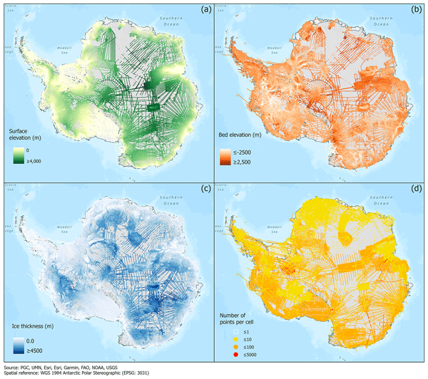
Alice C. Frémand, Peter Fretwell, Julien A. Bodart, Hamish D. Pritchard, Alan Aitken, Jonathan L. Bamber, Robin Bell, Cesidio Bianchi, Robert G. Bingham, Donald D. Blankenship, Gino Casassa, Ginny Catania, Knut Christianson, Howard Conway, Hugh F. J. Corr, Xiangbin Cui, Detlef Damaske, Volkmar Damm, Reinhard Drews, Graeme Eagles, Olaf Eisen, Hannes Eisermann, Fausto Ferraccioli, Elena Field, René Forsberg, Steven Franke, Shuji Fujita, Yonggyu Gim, Vikram Goel, Siva Prasad Gogineni, Jamin Greenbaum, Benjamin Hills, Richard C. A. Hindmarsh, Andrew O. Hoffman, Per Holmlund, Nicholas Holschuh, John W. Holt, Annika N. Horlings, Angelika Humbert, Robert W. Jacobel, Daniela Jansen, Adrian Jenkins, Wilfried Jokat, Tom Jordan, Edward King, Jack Kohler, William Krabill, Mette Kusk Gillespie, Kirsty Langley, Joohan Lee, German Leitchenkov, Carlton Leuschen, Bruce Luyendyk, Joseph MacGregor, Emma MacKie, Kenichi Matsuoka, Mathieu Morlighem, Jérémie Mouginot, Frank O. Nitsche, Yoshifumi Nogi, Ole A. Nost, John Paden, Frank Pattyn, Sergey V. Popov, Eric Rignot, David M. Rippin, Andrés Rivera, Jason Roberts, Neil Ross, Anotonia Ruppel, Dustin M. Schroeder, Martin J. Siegert, Andrew M. Smith, Daniel Steinhage, Michael Studinger, Bo Sun, Ignazio Tabacco, Kirsty Tinto, Stefano Urbini, David Vaughan, Brian C. Welch, Douglas S. Wilson, Duncan A. Young, and Achille Zirizzotti
Earth Syst. Sci. Data, 15, 2695–2710, https://doi.org/10.5194/essd-15-2695-2023, https://doi.org/10.5194/essd-15-2695-2023, 2023
Short summary
Short summary
This paper presents the release of over 60 years of ice thickness, bed elevation, and surface elevation data acquired over Antarctica by the international community. These data are a crucial component of the Antarctic Bedmap initiative which aims to produce a new map and datasets of Antarctic ice thickness and bed topography for the international glaciology and geophysical community.
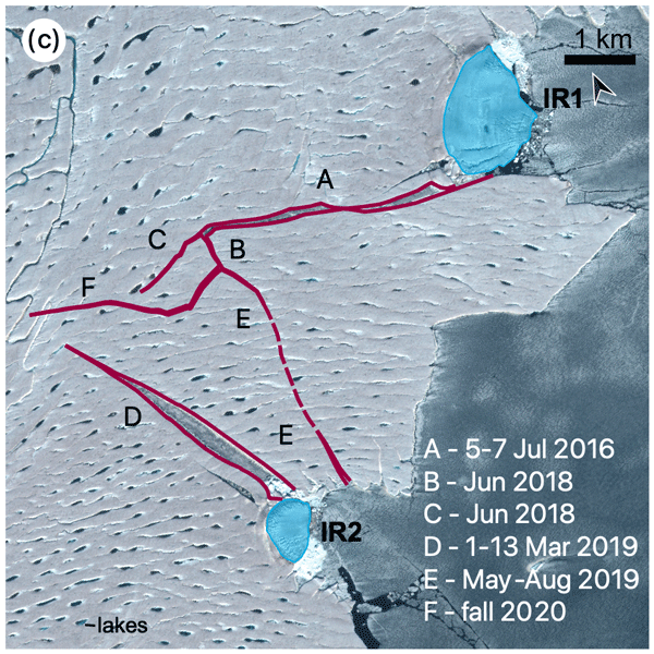
Angelika Humbert, Veit Helm, Niklas Neckel, Ole Zeising, Martin Rückamp, Shfaqat Abbas Khan, Erik Loebel, Jörg Brauchle, Karsten Stebner, Dietmar Gross, Rabea Sondershaus, and Ralf Müller
The Cryosphere, 17, 2851–2870, https://doi.org/10.5194/tc-17-2851-2023, https://doi.org/10.5194/tc-17-2851-2023, 2023
Short summary
Short summary
The largest floating glacier mass in Greenland, the 79° N Glacier, is showing signs of instability. We investigate how crack formation at the glacier's calving front has changed over the last decades by using satellite imagery and airborne data. The calving front is about to lose contact to stabilizing ice islands. Simulations show that the glacier will accelerate as a result of this, leading to an increase in ice discharge of more than 5.1 % if its calving front retreats by 46 %.
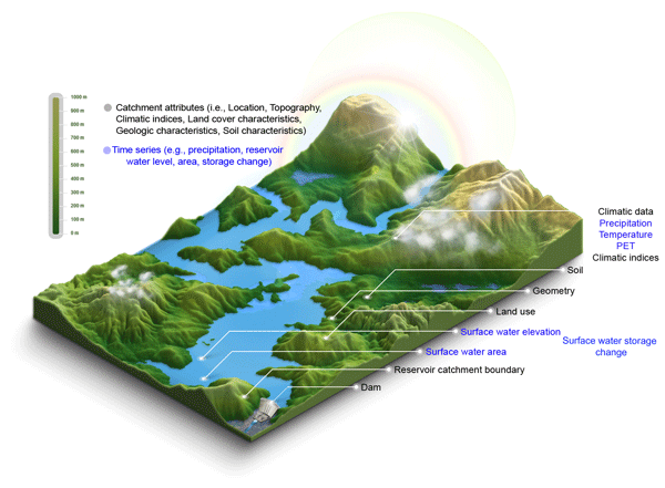
Youjiang Shen, Karina Nielsen, Menaka Revel, Dedi Liu, and Dai Yamazaki
Earth Syst. Sci. Data, 15, 2781–2808, https://doi.org/10.5194/essd-15-2781-2023, https://doi.org/10.5194/essd-15-2781-2023, 2023
Short summary
Short summary
Res-CN fills a gap in a comprehensive and extensive dataset of reservoir-catchment characteristics for 3254 Chinese reservoirs with 512 catchment-level attributes and significantly enhanced spatial and temporal coverage (e.g., 67 % increase in water level and 225 % in storage anomaly) of time series of reservoir water level (data available for 20 % of 3254 reservoirs), water area (99 %), storage anomaly (92 %), and evaporation (98 %), supporting a wide range of applications and disciplines.

Vishnu Nandan, Rosemary Willatt, Robbie Mallett, Julienne Stroeve, Torsten Geldsetzer, Randall Scharien, Rasmus Tonboe, John Yackel, Jack Landy, David Clemens-Sewall, Arttu Jutila, David N. Wagner, Daniela Krampe, Marcus Huntemann, Mallik Mahmud, David Jensen, Thomas Newman, Stefan Hendricks, Gunnar Spreen, Amy Macfarlane, Martin Schneebeli, James Mead, Robert Ricker, Michael Gallagher, Claude Duguay, Ian Raphael, Chris Polashenski, Michel Tsamados, Ilkka Matero, and Mario Hoppmann
The Cryosphere, 17, 2211–2229, https://doi.org/10.5194/tc-17-2211-2023, https://doi.org/10.5194/tc-17-2211-2023, 2023
Short summary
Short summary
We show that wind redistributes snow on Arctic sea ice, and Ka- and Ku-band radar measurements detect both newly deposited snow and buried snow layers that can affect the accuracy of snow depth estimates on sea ice. Radar, laser, meteorological, and snow data were collected during the MOSAiC expedition. With frequent occurrence of storms in the Arctic, our results show that
wind-redistributed snow needs to be accounted for to improve snow depth estimates on sea ice from satellite radars.
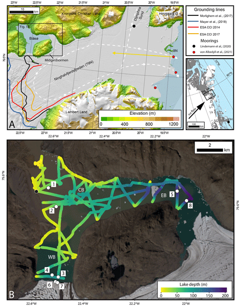
Michael J. Bentley, James A. Smith, Stewart S. R. Jamieson, Margaret R. Lindeman, Brice R. Rea, Angelika Humbert, Timothy P. Lane, Christopher M. Darvill, Jeremy M. Lloyd, Fiamma Straneo, Veit Helm, and David H. Roberts
The Cryosphere, 17, 1821–1837, https://doi.org/10.5194/tc-17-1821-2023, https://doi.org/10.5194/tc-17-1821-2023, 2023
Short summary
Short summary
The Northeast Greenland Ice Stream is a major outlet of the Greenland Ice Sheet. Some of its outlet glaciers and ice shelves have been breaking up and retreating, with inflows of warm ocean water identified as the likely reason. Here we report direct measurements of warm ocean water in an unusual lake that is connected to the ocean beneath the ice shelf in front of the 79° N Glacier. This glacier has not yet shown much retreat, but the presence of warm water makes future retreat more likely.
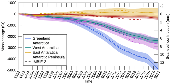
Inès N. Otosaka, Andrew Shepherd, Erik R. Ivins, Nicole-Jeanne Schlegel, Charles Amory, Michiel R. van den Broeke, Martin Horwath, Ian Joughin, Michalea D. King, Gerhard Krinner, Sophie Nowicki, Anthony J. Payne, Eric Rignot, Ted Scambos, Karen M. Simon, Benjamin E. Smith, Louise S. Sørensen, Isabella Velicogna, Pippa L. Whitehouse, Geruo A, Cécile Agosta, Andreas P. Ahlstrøm, Alejandro Blazquez, William Colgan, Marcus E. Engdahl, Xavier Fettweis, Rene Forsberg, Hubert Gallée, Alex Gardner, Lin Gilbert, Noel Gourmelen, Andreas Groh, Brian C. Gunter, Christopher Harig, Veit Helm, Shfaqat Abbas Khan, Christoph Kittel, Hannes Konrad, Peter L. Langen, Benoit S. Lecavalier, Chia-Chun Liang, Bryant D. Loomis, Malcolm McMillan, Daniele Melini, Sebastian H. Mernild, Ruth Mottram, Jeremie Mouginot, Johan Nilsson, Brice Noël, Mark E. Pattle, William R. Peltier, Nadege Pie, Mònica Roca, Ingo Sasgen, Himanshu V. Save, Ki-Weon Seo, Bernd Scheuchl, Ernst J. O. Schrama, Ludwig Schröder, Sebastian B. Simonsen, Thomas Slater, Giorgio Spada, Tyler C. Sutterley, Bramha Dutt Vishwakarma, Jan Melchior van Wessem, David Wiese, Wouter van der Wal, and Bert Wouters
Earth Syst. Sci. Data, 15, 1597–1616, https://doi.org/10.5194/essd-15-1597-2023, https://doi.org/10.5194/essd-15-1597-2023, 2023
Short summary
Short summary
By measuring changes in the volume, gravitational attraction, and ice flow of Greenland and Antarctica from space, we can monitor their mass gain and loss over time. Here, we present a new record of the Earth’s polar ice sheet mass balance produced by aggregating 50 satellite-based estimates of ice sheet mass change. This new assessment shows that the ice sheets have lost (7.5 x 10¹²) t of ice between 1992 and 2020, contributing 21 mm to sea level rise.
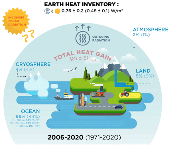
Karina von Schuckmann, Audrey Minière, Flora Gues, Francisco José Cuesta-Valero, Gottfried Kirchengast, Susheel Adusumilli, Fiammetta Straneo, Michaël Ablain, Richard P. Allan, Paul M. Barker, Hugo Beltrami, Alejandro Blazquez, Tim Boyer, Lijing Cheng, John Church, Damien Desbruyeres, Han Dolman, Catia M. Domingues, Almudena García-García, Donata Giglio, John E. Gilson, Maximilian Gorfer, Leopold Haimberger, Maria Z. Hakuba, Stefan Hendricks, Shigeki Hosoda, Gregory C. Johnson, Rachel Killick, Brian King, Nicolas Kolodziejczyk, Anton Korosov, Gerhard Krinner, Mikael Kuusela, Felix W. Landerer, Moritz Langer, Thomas Lavergne, Isobel Lawrence, Yuehua Li, John Lyman, Florence Marti, Ben Marzeion, Michael Mayer, Andrew H. MacDougall, Trevor McDougall, Didier Paolo Monselesan, Jan Nitzbon, Inès Otosaka, Jian Peng, Sarah Purkey, Dean Roemmich, Kanako Sato, Katsunari Sato, Abhishek Savita, Axel Schweiger, Andrew Shepherd, Sonia I. Seneviratne, Leon Simons, Donald A. Slater, Thomas Slater, Andrea K. Steiner, Toshio Suga, Tanguy Szekely, Wim Thiery, Mary-Louise Timmermans, Inne Vanderkelen, Susan E. Wjiffels, Tonghua Wu, and Michael Zemp
Earth Syst. Sci. Data, 15, 1675–1709, https://doi.org/10.5194/essd-15-1675-2023, https://doi.org/10.5194/essd-15-1675-2023, 2023
Short summary
Short summary
Earth's climate is out of energy balance, and this study quantifies how much heat has consequently accumulated over the past decades (ocean: 89 %, land: 6 %, cryosphere: 4 %, atmosphere: 1 %). Since 1971, this accumulated heat reached record values at an increasing pace. The Earth heat inventory provides a comprehensive view on the status and expectation of global warming, and we call for an implementation of this global climate indicator into the Paris Agreement’s Global Stocktake.
Robert Ricker, Steven Fons, Arttu Jutila, Nils Hutter, Kyle Duncan, Sinead L. Farrell, Nathan T. Kurtz, and Renée Mie Fredensborg Hansen
The Cryosphere, 17, 1411–1429, https://doi.org/10.5194/tc-17-1411-2023, https://doi.org/10.5194/tc-17-1411-2023, 2023
Short summary
Short summary
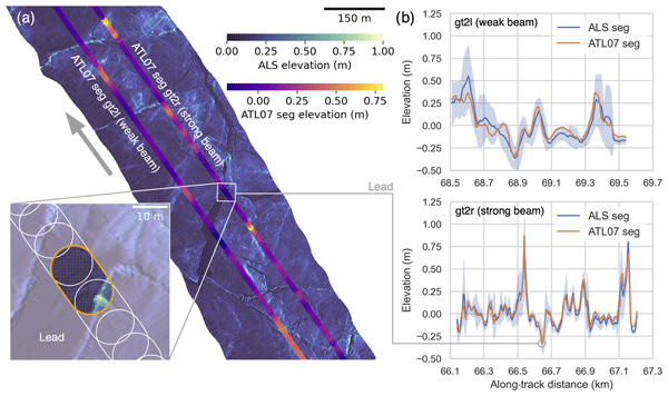
Information on sea ice surface topography is important for studies of sea ice as well as for ship navigation through ice. The ICESat-2 satellite senses the sea ice surface with six laser beams. To examine the accuracy of these measurements, we carried out a temporally coincident helicopter flight along the same ground track as the satellite and measured the sea ice surface topography with a laser scanner. This showed that ICESat-2 can see even bumps of only few meters in the sea ice cover.
Monica Coppo Frias, Suxia Liu, Xingguo Mo, Karina Nielsen, Heidi Ranndal, Liguang Jiang, Jun Ma, and Peter Bauer-Gottwein
Hydrol. Earth Syst. Sci., 27, 1011–1032, https://doi.org/10.5194/hess-27-1011-2023, https://doi.org/10.5194/hess-27-1011-2023, 2023
Short summary
Short summary
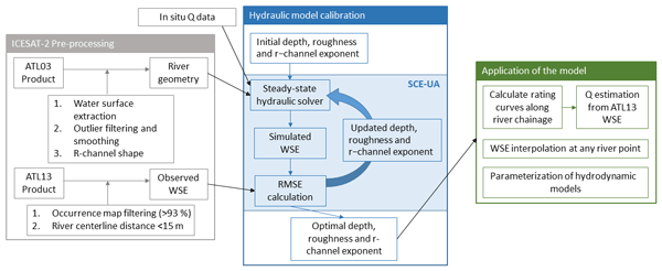
This paper uses remote sensing data from ICESat-2 to calibrate a 1D hydraulic model. With the model, we can make estimations of discharge and water surface elevation, which are important indicators in flooding risk assessment. ICESat-2 data give an added value, thanks to the 0.7 m resolution, which allows the measurement of narrow river streams. In addition, ICESat-2 provides measurements on the river dry portion geometry that can be included in the model.
Tian Li, Geoffrey J. Dawson, Stephen J. Chuter, and Jonathan L. Bamber
The Cryosphere, 17, 1003–1022, https://doi.org/10.5194/tc-17-1003-2023, https://doi.org/10.5194/tc-17-1003-2023, 2023
Short summary
Short summary
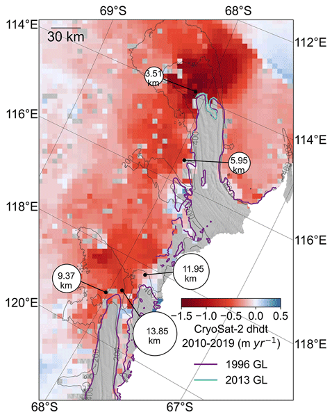
The Totten and Moscow University glaciers in East Antarctica have the potential to make a significant contribution to future sea-level rise. We used a combination of different satellite measurements to show that the grounding lines have been retreating along the fast-flowing ice streams across these two glaciers. We also found two tide-modulated ocean channels that might open new pathways for the warm ocean water to enter the ice shelf cavity.
Antonis Gkikas, Anna Gialitaki, Ioannis Binietoglou, Eleni Marinou, Maria Tsichla, Nikolaos Siomos, Peristera Paschou, Anna Kampouri, Kalliopi Artemis Voudouri, Emmanouil Proestakis, Maria Mylonaki, Christina-Anna Papanikolaou, Konstantinos Michailidis, Holger Baars, Anne Grete Straume, Dimitris Balis, Alexandros Papayannis, Tomasso Parrinello, and Vassilis Amiridis
Atmos. Meas. Tech., 16, 1017–1042, https://doi.org/10.5194/amt-16-1017-2023, https://doi.org/10.5194/amt-16-1017-2023, 2023
Short summary
Short summary
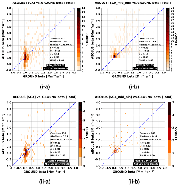
We perform an assessment analysis of the Aeolus Standard Correct Algorithm (SCA) backscatter coefficient retrievals against reference observations acquired at three Greek lidar stations (Athens, Thessaloniki and Antikythera) of the PANACEA network. Overall, 43 cases are analysed, whereas specific aerosol scenarios in the vicinity of Antikythera island (SW Greece) are emphasised. All key Cal/Val aspects and recommendations, and the ongoing related activities, are thoroughly discussed.
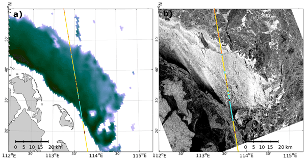
Felix L. Müller, Stephan Paul, Stefan Hendricks, and Denise Dettmering
The Cryosphere, 17, 809–825, https://doi.org/10.5194/tc-17-809-2023, https://doi.org/10.5194/tc-17-809-2023, 2023
Short summary
Short summary
Thinning sea ice has significant impacts on the energy exchange between the atmosphere and the ocean. In this study we present visual and quantitative comparisons of thin-ice detections obtained from classified Cryosat-2 radar reflections and thin-ice-thickness estimates derived from MODIS thermal-infrared imagery. In addition to good comparability, the results of the study indicate the potential for a deeper understanding of sea ice in the polar seas and improved processing of altimeter data.
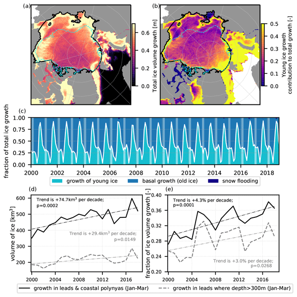
Guillaume Boutin, Einar Ólason, Pierre Rampal, Heather Regan, Camille Lique, Claude Talandier, Laurent Brodeau, and Robert Ricker
The Cryosphere, 17, 617–638, https://doi.org/10.5194/tc-17-617-2023, https://doi.org/10.5194/tc-17-617-2023, 2023
Short summary
Short summary
Sea ice cover in the Arctic is full of cracks, which we call leads. We suspect that these leads play a role for atmosphere–ocean interactions in polar regions, but their importance remains challenging to estimate. We use a new ocean–sea ice model with an original way of representing sea ice dynamics to estimate their impact on winter sea ice production. This model successfully represents sea ice evolution from 2000 to 2018, and we find that about 30 % of ice production takes place in leads.
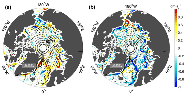
Francesca Doglioni, Robert Ricker, Benjamin Rabe, Alexander Barth, Charles Troupin, and Torsten Kanzow
Earth Syst. Sci. Data, 15, 225–263, https://doi.org/10.5194/essd-15-225-2023, https://doi.org/10.5194/essd-15-225-2023, 2023
Short summary
Short summary
This paper presents a new satellite-derived gridded dataset, including 10 years of sea surface height and geostrophic velocity at monthly resolution, over the Arctic ice-covered and ice-free regions, up to 88° N. We assess the dataset by comparison to independent satellite and mooring data. Results correlate well with independent satellite data at monthly timescales, and the geostrophic velocity fields can resolve seasonal to interannual variability of boundary currents wider than about 50 km.

Youjiang Shen, Dedi Liu, Liguang Jiang, Karina Nielsen, Jiabo Yin, Jun Liu, and Peter Bauer-Gottwein
Earth Syst. Sci. Data, 14, 5671–5694, https://doi.org/10.5194/essd-14-5671-2022, https://doi.org/10.5194/essd-14-5671-2022, 2022
Short summary
Short summary
A data gap of 338 Chinese reservoirs with their surface water area (SWA), water surface elevation (WSE), and reservoir water storage change (RWSC) during 2010–2021. Validation against the in situ observations of 93 reservoirs indicates the relatively high accuracy and reliability of the datasets. The unique and novel remotely sensed dataset would benefit studies involving many aspects (e.g., hydrological models, water resources related studies, and more).
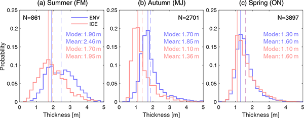
Jinfei Wang, Chao Min, Robert Ricker, Qian Shi, Bo Han, Stefan Hendricks, Renhao Wu, and Qinghua Yang
The Cryosphere, 16, 4473–4490, https://doi.org/10.5194/tc-16-4473-2022, https://doi.org/10.5194/tc-16-4473-2022, 2022
Short summary
Short summary
The differences between Envisat and ICESat sea ice thickness (SIT) reveal significant temporal and spatial variations. Our findings suggest that both overestimation of Envisat sea ice freeboard, potentially caused by radar backscatter originating from inside the snow layer, and the AMSR-E snow depth biases and sea ice density uncertainties can possibly account for the differences between Envisat and ICESat SIT.
Julienne Stroeve, Vishnu Nandan, Rosemary Willatt, Ruzica Dadic, Philip Rostosky, Michael Gallagher, Robbie Mallett, Andrew Barrett, Stefan Hendricks, Rasmus Tonboe, Michelle McCrystall, Mark Serreze, Linda Thielke, Gunnar Spreen, Thomas Newman, John Yackel, Robert Ricker, Michel Tsamados, Amy Macfarlane, Henna-Reetta Hannula, and Martin Schneebeli
The Cryosphere, 16, 4223–4250, https://doi.org/10.5194/tc-16-4223-2022, https://doi.org/10.5194/tc-16-4223-2022, 2022
Short summary
Short summary
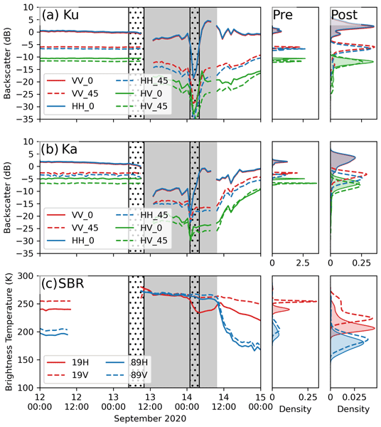
Impacts of rain on snow (ROS) on satellite-retrieved sea ice variables remain to be fully understood. This study evaluates the impacts of ROS over sea ice on active and passive microwave data collected during the 2019–20 MOSAiC expedition. Rainfall and subsequent refreezing of the snowpack significantly altered emitted and backscattered radar energy, laying important groundwork for understanding their impacts on operational satellite retrievals of various sea ice geophysical variables.
Angelika Humbert, Julia Christmann, Hugh F. J. Corr, Veit Helm, Lea-Sophie Höyns, Coen Hofstede, Ralf Müller, Niklas Neckel, Keith W. Nicholls, Timm Schultz, Daniel Steinhage, Michael Wolovick, and Ole Zeising
The Cryosphere, 16, 4107–4139, https://doi.org/10.5194/tc-16-4107-2022, https://doi.org/10.5194/tc-16-4107-2022, 2022
Short summary
Short summary
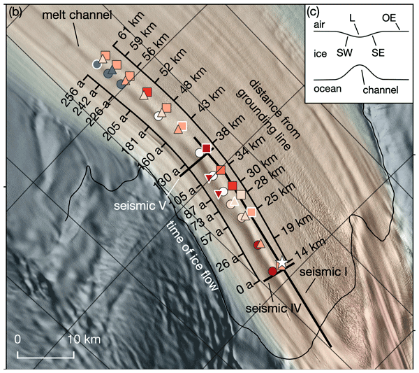
Ice shelves are normally flat structures that fringe the Antarctic continent. At some locations they have channels incised into their underside. On Filchner Ice Shelf, such a channel is more than 50 km long and up to 330 m high. We conducted field measurements of basal melt rates and found a maximum of 2 m yr−1. Simulations represent the geometry evolution of the channel reasonably well. There is no reason to assume that this type of melt channel is destabilizing ice shelves.
Sam Royston, Rory J. Bingham, and Jonathan L. Bamber
Ocean Sci., 18, 1093–1107, https://doi.org/10.5194/os-18-1093-2022, https://doi.org/10.5194/os-18-1093-2022, 2022
Short summary
Short summary
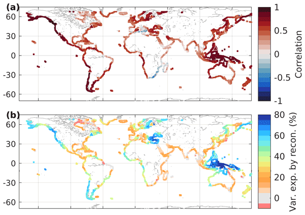
Decadal sea-level variability masks longer-term changes and increases uncertainty in observed trend and acceleration estimates. We use numerical ocean models to determine the magnitude of decadal variability we might expect in sea-level trends at coastal locations around the world, resulting from natural, internal variability. A proportion of that variability can be replicated from known climate modes, giving a range to add to short- to mid-term projections of regional sea-level trends.
David N. Wagner, Matthew D. Shupe, Christopher Cox, Ola G. Persson, Taneil Uttal, Markus M. Frey, Amélie Kirchgaessner, Martin Schneebeli, Matthias Jaggi, Amy R. Macfarlane, Polona Itkin, Stefanie Arndt, Stefan Hendricks, Daniela Krampe, Marcel Nicolaus, Robert Ricker, Julia Regnery, Nikolai Kolabutin, Egor Shimanshuck, Marc Oggier, Ian Raphael, Julienne Stroeve, and Michael Lehning
The Cryosphere, 16, 2373–2402, https://doi.org/10.5194/tc-16-2373-2022, https://doi.org/10.5194/tc-16-2373-2022, 2022
Short summary
Short summary
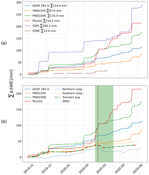
Based on measurements of the snow cover over sea ice and atmospheric measurements, we estimate snowfall and snow accumulation for the MOSAiC ice floe, between November 2019 and May 2020. For this period, we estimate 98–114 mm of precipitation. We suggest that about 34 mm of snow water equivalent accumulated until the end of April 2020 and that at least about 50 % of the precipitated snow was eroded or sublimated. Further, we suggest explanations for potential snowfall overestimation.
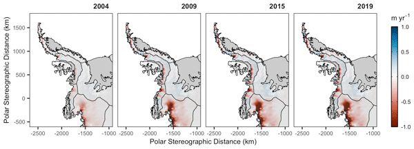
Stephen J. Chuter, Andrew Zammit-Mangion, Jonathan Rougier, Geoffrey Dawson, and Jonathan L. Bamber
The Cryosphere, 16, 1349–1367, https://doi.org/10.5194/tc-16-1349-2022, https://doi.org/10.5194/tc-16-1349-2022, 2022
Short summary
Short summary
We find the Antarctic Peninsula to have a mean mass loss of 19 ± 1.1 Gt yr−1 over the 2003–2019 period, driven predominantly by changes in ice dynamic flow like due to changes in ocean forcing. This long-term record is crucial to ascertaining the region’s present-day contribution to sea level rise, with the understanding of driving processes enabling better future predictions. Our statistical approach enables us to estimate this previously poorly surveyed regions mass balance more accurately.
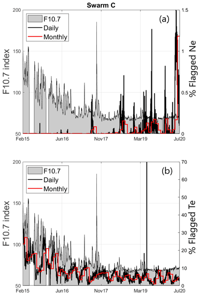
Filomena Catapano, Stephan Buchert, Enkelejda Qamili, Thomas Nilsson, Jerome Bouffard, Christian Siemes, Igino Coco, Raffaella D'Amicis, Lars Tøffner-Clausen, Lorenzo Trenchi, Poul Erik Holmdahl Olsen, and Anja Stromme
Geosci. Instrum. Method. Data Syst., 11, 149–162, https://doi.org/10.5194/gi-11-149-2022, https://doi.org/10.5194/gi-11-149-2022, 2022
Short summary
Short summary
The quality control and validation activities performed by the Swarm data quality team reveal the good-quality LPs. The analysis demonstrated that the current baseline plasma data products are improved with respect to previous baseline. The LPs have captured the ionospheric plasma variability over more than half of a solar cycle, revealing the data quality dependence on the solar activity. The quality of the LP data will further improve promotion of their application to a broad range of studies.
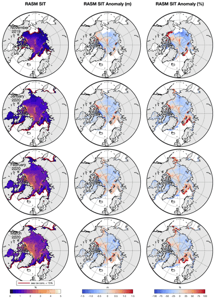
Klaus Dethloff, Wieslaw Maslowski, Stefan Hendricks, Younjoo J. Lee, Helge F. Goessling, Thomas Krumpen, Christian Haas, Dörthe Handorf, Robert Ricker, Vladimir Bessonov, John J. Cassano, Jaclyn Clement Kinney, Robert Osinski, Markus Rex, Annette Rinke, Julia Sokolova, and Anja Sommerfeld
The Cryosphere, 16, 981–1005, https://doi.org/10.5194/tc-16-981-2022, https://doi.org/10.5194/tc-16-981-2022, 2022
Short summary
Short summary
Sea ice thickness anomalies during the MOSAiC (Multidisciplinary drifting Observatory for the Study of Arctic Climate) winter in January, February and March 2020 were simulated with the coupled Regional Arctic climate System Model (RASM) and compared with CryoSat-2/SMOS satellite data. Hindcast and ensemble simulations indicate that the sea ice anomalies are driven by nonlinear interactions between ice growth processes and wind-driven sea-ice transports, with dynamics playing a dominant role.
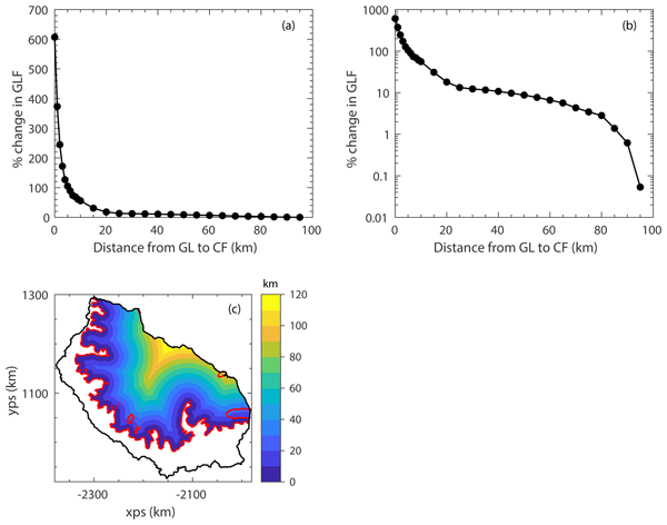
Tom Mitcham, G. Hilmar Gudmundsson, and Jonathan L. Bamber
The Cryosphere, 16, 883–901, https://doi.org/10.5194/tc-16-883-2022, https://doi.org/10.5194/tc-16-883-2022, 2022
Short summary
Short summary
We modelled the response of the Larsen C Ice Shelf (LCIS) and its tributary glaciers to the calving of the A68 iceberg and validated our results with observations. We found that the impact was limited, confirming that mostly passive ice was calved. Through further calving experiments we quantified the total buttressing provided by the LCIS and found that over 80 % of the buttressing capacity is generated in the first 5 km of the ice shelf downstream of the grounding line.
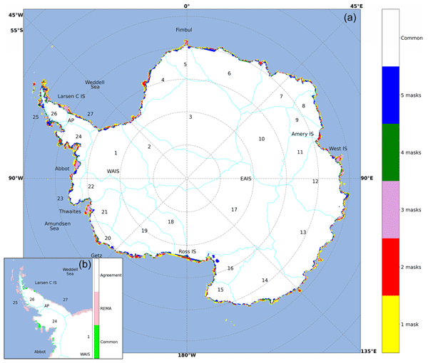
Nicolaj Hansen, Sebastian B. Simonsen, Fredrik Boberg, Christoph Kittel, Andrew Orr, Niels Souverijns, J. Melchior van Wessem, and Ruth Mottram
The Cryosphere, 16, 711–718, https://doi.org/10.5194/tc-16-711-2022, https://doi.org/10.5194/tc-16-711-2022, 2022
Short summary
Short summary
We investigate the impact of different ice masks when modelling surface mass balance over Antarctica. We used ice masks and data from five of the most used regional climate models and a common mask. We see large disagreement between the ice masks, which has a large impact on the surface mass balance, especially around the Antarctic Peninsula and some of the largest glaciers. We suggest a solution for creating a new, up-to-date, high-resolution ice mask that can be used in Antarctic modelling.
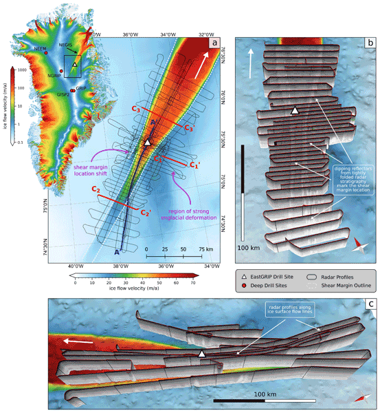
Steven Franke, Daniela Jansen, Tobias Binder, John D. Paden, Nils Dörr, Tamara A. Gerber, Heinrich Miller, Dorthe Dahl-Jensen, Veit Helm, Daniel Steinhage, Ilka Weikusat, Frank Wilhelms, and Olaf Eisen
Earth Syst. Sci. Data, 14, 763–779, https://doi.org/10.5194/essd-14-763-2022, https://doi.org/10.5194/essd-14-763-2022, 2022
Short summary
Short summary
The Northeast Greenland Ice Stream (NEGIS) is the largest ice stream in Greenland. In order to better understand the past and future dynamics of the NEGIS, we present a high-resolution airborne radar data set (EGRIP-NOR-2018) for the onset region of the NEGIS. The survey area is centered at the location of the drill site of the East Greenland Ice-Core Project (EastGRIP), and radar profiles cover both shear margins and are aligned parallel to several flow lines.
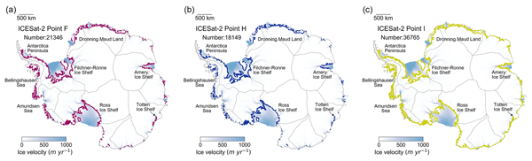
Tian Li, Geoffrey J. Dawson, Stephen J. Chuter, and Jonathan L. Bamber
Earth Syst. Sci. Data, 14, 535–557, https://doi.org/10.5194/essd-14-535-2022, https://doi.org/10.5194/essd-14-535-2022, 2022
Short summary
Short summary
Accurate knowledge of the Antarctic grounding zone is important for mass balance calculation, ice sheet stability assessment, and ice sheet model projections. Here we present the first ICESat-2-derived high-resolution grounding zone product of the Antarctic Ice Sheet, including three important boundaries. This new data product will provide more comprehensive insights into ice sheet instability, which is valuable for both the cryosphere and sea level science communities.
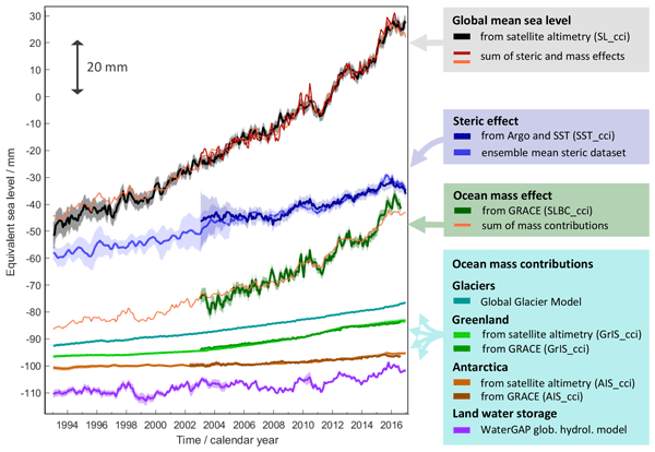
Martin Horwath, Benjamin D. Gutknecht, Anny Cazenave, Hindumathi Kulaiappan Palanisamy, Florence Marti, Ben Marzeion, Frank Paul, Raymond Le Bris, Anna E. Hogg, Inès Otosaka, Andrew Shepherd, Petra Döll, Denise Cáceres, Hannes Müller Schmied, Johnny A. Johannessen, Jan Even Øie Nilsen, Roshin P. Raj, René Forsberg, Louise Sandberg Sørensen, Valentina R. Barletta, Sebastian B. Simonsen, Per Knudsen, Ole Baltazar Andersen, Heidi Ranndal, Stine K. Rose, Christopher J. Merchant, Claire R. Macintosh, Karina von Schuckmann, Kristin Novotny, Andreas Groh, Marco Restano, and Jérôme Benveniste
Earth Syst. Sci. Data, 14, 411–447, https://doi.org/10.5194/essd-14-411-2022, https://doi.org/10.5194/essd-14-411-2022, 2022
Short summary
Short summary
Global mean sea-level change observed from 1993 to 2016 (mean rate of 3.05 mm yr−1) matches the combined effect of changes in water density (thermal expansion) and ocean mass. Ocean-mass change has been assessed through the contributions from glaciers, ice sheets, and land water storage or directly from satellite data since 2003. Our budget assessments of linear trends and monthly anomalies utilise new datasets and uncertainty characterisations developed within ESA's Climate Change Initiative.
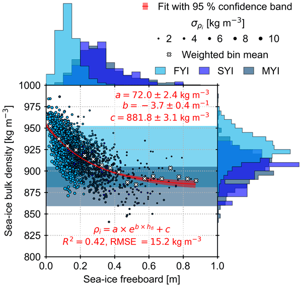
Arttu Jutila, Stefan Hendricks, Robert Ricker, Luisa von Albedyll, Thomas Krumpen, and Christian Haas
The Cryosphere, 16, 259–275, https://doi.org/10.5194/tc-16-259-2022, https://doi.org/10.5194/tc-16-259-2022, 2022
Short summary
Short summary
Sea-ice thickness retrieval from satellite altimeters relies on assumed sea-ice density values because density cannot be measured from space. We derived bulk densities for different ice types using airborne laser, radar, and electromagnetic induction sounding measurements. Compared to previous studies, we found high bulk density values due to ice deformation and younger ice cover. Using sea-ice freeboard, we derived a sea-ice bulk density parameterisation that can be applied to satellite data.
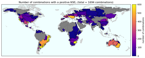
Fanny Lehmann, Bramha Dutt Vishwakarma, and Jonathan Bamber
Hydrol. Earth Syst. Sci., 26, 35–54, https://doi.org/10.5194/hess-26-35-2022, https://doi.org/10.5194/hess-26-35-2022, 2022
Short summary
Short summary
Many data sources are available to evaluate components of the water cycle (precipitation, evapotranspiration, runoff, and terrestrial water storage). Despite this variety, it remains unclear how different combinations of datasets satisfy the conservation of mass. We conducted the most comprehensive analysis of water budget closure on a global scale to date. Our results can serve as a basis to select appropriate datasets for regional hydrological studies.
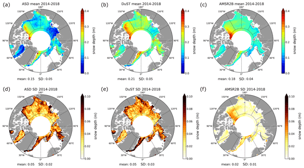
Florent Garnier, Sara Fleury, Gilles Garric, Jérôme Bouffard, Michel Tsamados, Antoine Laforge, Marion Bocquet, Renée Mie Fredensborg Hansen, and Frédérique Remy
The Cryosphere, 15, 5483–5512, https://doi.org/10.5194/tc-15-5483-2021, https://doi.org/10.5194/tc-15-5483-2021, 2021
Short summary
Short summary
Snow depth data are essential to monitor the impacts of climate change on sea ice volume variations and their impacts on the climate system. For that purpose, we present and assess the altimetric snow depth product, computed in both hemispheres from CryoSat-2 and SARAL satellite data. The use of these data instead of the common climatology reduces the sea ice thickness by about 30 cm over the 2013–2019 period. These data are also crucial to argue for the launch of the CRISTAL satellite mission.
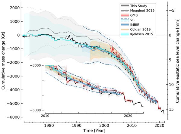
Kenneth D. Mankoff, Xavier Fettweis, Peter L. Langen, Martin Stendel, Kristian K. Kjeldsen, Nanna B. Karlsson, Brice Noël, Michiel R. van den Broeke, Anne Solgaard, William Colgan, Jason E. Box, Sebastian B. Simonsen, Michalea D. King, Andreas P. Ahlstrøm, Signe Bech Andersen, and Robert S. Fausto
Earth Syst. Sci. Data, 13, 5001–5025, https://doi.org/10.5194/essd-13-5001-2021, https://doi.org/10.5194/essd-13-5001-2021, 2021
Short summary
Short summary
We estimate the daily mass balance and its components (surface, marine, and basal mass balance) for the Greenland ice sheet. Our time series begins in 1840 and has annual resolution through 1985 and then daily from 1986 through next week. Results are operational (updated daily) and provided for the entire ice sheet or by commonly used regions or sectors. This is the first input–output mass balance estimate to include the basal mass balance.
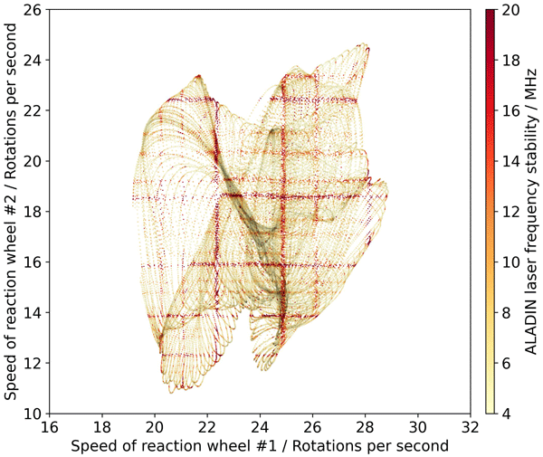
Oliver Lux, Christian Lemmerz, Fabian Weiler, Thomas Kanitz, Denny Wernham, Gonçalo Rodrigues, Andrew Hyslop, Olivier Lecrenier, Phil McGoldrick, Frédéric Fabre, Paolo Bravetti, Tommaso Parrinello, and Oliver Reitebuch
Atmos. Meas. Tech., 14, 6305–6333, https://doi.org/10.5194/amt-14-6305-2021, https://doi.org/10.5194/amt-14-6305-2021, 2021
Short summary
Short summary
The work assesses the frequency stability of the laser transmitters on board Aeolus and discusses its influence on the quality of the global wind data. Excellent frequency stability of the space lasers is evident, although enhanced frequency noise occurs at certain locations along the orbit due to micro-vibrations that are introduced by the satellite’s reaction wheels. The study elaborates on this finding and investigates the extent to which the enhanced frequency noise increases the wind error.
Cited articles
Armitage, T. W. K. and Davidson, M. W. J.: Using the Interferometric
Capabilities of the ESA CryoSat-2 Mission to Improve the Accuracy of Sea Ice
Freeboard Retrievals, IEEE T. Geosci. Remote,
52, 529–536, 2014.
Bouffard, J., Naeije, M., Banks, C., Calafat, F. M., Cipollini, P., Snaith,
H. M., Webb, E., Hall, A., Mannan, R., Féménias, P., and Parrinello,
T.: CryoSat ocean product quality status and future evolution, Adv.
Space Res., 62, 1549–1563, doi:10.1016/j.asr.2017.11.043, 2018a.
Bouffard, J., Webb, E., Scagliola, M., Garcia-Mondéjar, A., Baker, S.,
Brockley, D., Gaudelli, J., Muir, A., Hall, A., Mannan, R., Roca, M.,
Fornari, M., Féménias, P., and Parrinello, T.: CryoSat instrument
performance and ice product quality status, Adv. Space Res.,
62, 1526–1548, https://doi.org/10.1016/j.asr.2017.11.024, 2018b.
CSEM Report 2017: Summary and Recommendations Report of the CryoSat-2 Expert
Meeting, available at: https://earth.esa.int/documents/10174/1822995/CryoSat-CSEM-Summary-and-Recommendations-Report.pdf (last access: October 2019),
2018.
Di Bella, A., Skourup, H., Bouffard, J., and Parrinello, T.: Uncertainty
reduction of arctic sea ice freeboard from CryoSat-2 interferometric mode,
Adv. Space Res., 62, 1251–1264, 2018.
Di Bella, A., Scagliola, M., Maestri, L., Skourup, H., and Forsberg, R.:
Improving CryoSat SARIn L1b products to account for inaccurate phase
difference: impact on sea ice freeboard retrieval, IEEE Geosci.
Remote S., 17, 252–256, doi:10.1109/LGRS.2019.2919946, 2019.
Dunse, T., Schuler, T. V., Hagen, J. O., and Reijmer, C. H.: Seasonal speed-up of two outlet glaciers of Austfonna, Svalbard, inferred from continuous GPS measurements, The Cryosphere, 6, 453–466, https://doi.org/10.5194/tc-6-453-2012, 2012.
Dunse, T., Schellenberger, T., Hagen, J. O., Kääb, A., Schuler, T. V., and Reijmer, C. H.: Glacier-surge mechanisms promoted by a hydro-thermodynamic feedback to summer melt, The Cryosphere, 9, 197–215, https://doi.org/10.5194/tc-9-197-2015, 2015.
ESA: CryoSat Data, available at: https://science-pds.cryosat.esa.int/, last access: January 2020.
Fornari, M., Scagliola, M., Tagliani, N., Parrinello, T., and Mondejar, A.
G.: CryoSat: Siral calibration and performance, IEEE Geosci. Remote
Se., July 2014, 702–705, 2014.
Gourmelen, N., Goldberg, D. N., Snow, K., Henley, S. F., Bingham, R.
G., Kimura, S., Hogg, E., Sheperd, A., Mouginot, J., Lenaerts, J.,
Ligtenberg, S. R. M. and Berg, W. J.: Channelized melting drives thinning
under a rapidly melting Antarctic ice shelf, Geophysical Research
Letters, 44, 9796– 9804, https://doi.org/10.1002/2017GL074929, 2017.
Gourmelen, N., Escorihuela, M.J., Shepherd, A., Foresta, L., Muir, A.,
Garcia-Mondejar, A., Roca, M., Baker, S. G., and Drinkwater, M. R.: CryoSat-2
swath interferometric altimetry for mapping ice elevation and elevation
change, Adv. Space Res., 62, 1226–1242, https://doi.org/10.1016/j.asr.2017.11.014, 2018.
Gray, L., Burgess, D., Copland, L., Cullen, R., Galin, N., Hawley, R., and Helm, V.: Interferometric swath processing of Cryosat data for glacial ice topography, The Cryosphere, 7, 1857–1867, https://doi.org/10.5194/tc-7-1857-2013, 2013.
Gray, L., Burgess, D., Copland, L., Demuth, M. N., Dunse, T., Langley, K., and Schuler, T. V.: CryoSat-2 delivers monthly and inter-annual surface elevation change for Arctic ice caps, The Cryosphere, 9, 1895–1913, https://doi.org/10.5194/tc-9-1895-2015, 2015.
Gray, L., Burgess, D., Copland, L., Dunse, T., Langley, K., and Moholdt, G.: A revised calibration of the interferometric mode of the CryoSat-2 radar altimeter improves ice height and height change measurements in western Greenland, The Cryosphere, 11, 1041–1058, https://doi.org/10.5194/tc-11-1041-2017, 2017.
Guerreiro, K., Fleury, S., Zakharova, E., Kouraev, A., Rémy, F., and Maisongrande, P.: Comparison of CryoSat-2 and ENVISAT radar freeboard over Arctic sea ice: toward an improved Envisat freeboard retrieval, The Cryosphere, 11, 2059–2073, https://doi.org/10.5194/tc-11-2059-2017, 2017.
Helm, V., Humbert, A., and Miller, H.: Elevation and elevation change of Greenland and Antarctica derived from CryoSat-2, The Cryosphere, 8, 1539–1559, https://doi.org/10.5194/tc-8-1539-2014, 2014.
Hendricks, S., Paul, S., and Rinne, E.: ESA Sea Ice Climate Change Initiative
(Sea_Ice_cci): Northern hemisphere sea ice
thickness from the CryoSat-2 satellite on a monthly grid (L3C), v2.0, Centre
for Environmental Data Analysis, https://doi.org/10.5285/ff79d140824f42dd92b204b4f1e9e7c2, 2018a.
Hendricks, S. and Ricker, R.: Sea Ice Thickness: Product User Guide and
Specification, Copernicus Climate Change Services (C3S), Technical Report
version 1.1 (Ref: C3S_D312a_lot1.3.3.3-v1_201805_PUGS_v1.1), http://datastore.copernicus-climate.eu/c3s/published-forms/c3sprod/satellite-sea-ice/product-user-guide-sea-ice-thickness.pdf (last access: November 2019),
2018b.
Hendricks, S. and Ricker, R.: Product User Guide & Algorithm
Specification: AWI CryoSat-2 Sea Ice Thickness (version 2.1), Technical
Report, https://epic.awi.de/id/eprint/49542/, last access October, 2019.
Howat, I. M., Porter, C., Smith, B. E., Noh, M.-J., and Morin, P.: The Reference Elevation Model of Antarctica, The Cryosphere, 13, 665–674, https://doi.org/10.5194/tc-13-665-2019, 2019.
Jiang, L., Nielsen, K., Andersen, O. B., and Bauer-Gottwein, P.: Monitoring
recent lake level variations on the Tibetan Plateau using CryoSat-2 SARIn
mode data, J. Hydrol., 544, 109–124, doi:10.1016/j.jhydrol.2016.11.024, 2017
Kurtz, N. T., Farrell, S. L., Studinger, M., Galin, N., Harbeck, J. P., Lindsay, R., Onana, V. D., Panzer, B., and Sonntag, J. G.: Sea ice thickness, freeboard, and snow depth products from Operation IceBridge airborne data, The Cryosphere, 7, 1035–1056, https://doi.org/10.5194/tc-7-1035-2013, 2013.
Kurtz, N. T., Galin, N., and Studinger, M.: An improved CryoSat-2 sea ice freeboard retrieval algorithm through the use of waveform fitting, The Cryosphere, 8, 1217–1237, https://doi.org/10.5194/tc-8-1217-2014, 2014.
Kwok, R. and Cunningham, G. F.: Variability of Arctic sea ice thickness and
volume from CryoSat-2, Phil. Trans. R. Soc. A, 2015, 37320140157, doi:10.1098/rsta.2014.0157, 2015.
Laxon, S., Peacock, N., and Smith, D.: High interannual variability of sea
ice thickness in the Arctic region, Nature, 425, 947–950, 2003.
Lee, S., Kim, H.-C., and Im, J.: Arctic lead detection using a waveform mixture algorithm from CryoSat-2 data, The Cryosphere, 12, 1665–1679, https://doi.org/10.5194/tc-12-1665-2018, 2018.
Lehner, B. and Döll, P.: Development and validation of a global
database of lakes, reservoirs and wetlands, J. Hydrol., 296,
1–22, 2004.
McMillan, M., Shepherd, A., Sundal, A., Briggs, K., Muir, A., Ridout, A.,
Hogg, A., and Wingham, D.: Increased ice losses from Antarctica detected by
CryoSat-2, Geophys. Res. Lett., 41, 3899–3905, doi:10.1002/2014GL060111, 2014.
Nielsen, K., Stenseng, L., Andersen, B., Villadsen, H., and Knudsen, P.:
Validation of CryoSat-2 SAR mode based lake levels, Remote Sens. Environ., 171, 162–170, doi:10.1016/j.rse.2015.10.023, 2015.
Nilsson, J., Vallelonga, P., Simonsen, S., Sørensen, L., Forsberg, R.,
Dahl-Jensen, D., Hirabayashi, M., Goto-Azuma, K., Hvidberg, C., Kjær,
H., and Satow, K.: Greenland 2012 melt event effects on CryoSat-2 radar
altimetry: Effect of Greenland melt on CryoSat-2, Geophys. Res.
Lett., 42, 3919–3926, doi:10.1002/2015GL063296, 2015.
Nilsson, J., Gardner, A., Sandberg Sørensen, L., and Forsberg, R.: Improved retrieval of land ice topography from CryoSat-2 data and its impact for volume-change estimation of the Greenland Ice Sheet, The Cryosphere, 10, 2953–2969, https://doi.org/10.5194/tc-10-2953-2016, 2016.
Passaro, M., Müller, F., and Dettmering, D.: Lead detection using
CryoSat-2 delay-doppler processing and Sentinel-1 SAR images, Adv.
Space Res., 62, 1610–1625, 2018.
Paul, S., Hendricks, S., Ricker, R., Kern, S., and Rinne, E.: Empirical parametrization of Envisat freeboard retrieval of Arctic and Antarctic sea ice based on CryoSat-2: progress in the ESA Climate Change Initiative, The Cryosphere, 12, 2437–2460, https://doi.org/10.5194/tc-12-2437-2018, 2018.
Raney, R. K.: The delay/Doppler radar altimeter, IEEE T. Geosci. Remote, 36, 1578–1588, 1998.
Ricker, R., Hendricks, S., Helm, V., Skourup, H., and Davidson, M.: Sensitivity of CryoSat-2 Arctic sea-ice freeboard and thickness on radar-waveform interpretation, The Cryosphere, 8, 1607–1622, https://doi.org/10.5194/tc-8-1607-2014, 2014.
Roemer, S., Legrésy, B., Horwath, M., and Dietrich, R.: Refined analysis
of radar altimetry data applied to the region of the subglacial Lake
Vostok/Antarctica, Remote Sens. Environ., 106, 269–284,
doi:10.1016/j.rse.2006.02.026, 2007.
Sandberg Sørensen, L., Simonsen, S., Langley, K., Gray, L., Helm,
V., Nilsson, J., Stenseng, L., Skourup, H., Forsberg, R., and Davidson,
M.: Validation of CryoSat-2 SARIn Data over Austfonna Ice Cap Using Airborne
Laser Scanner Measurements, Remote Sens., 10, 1354, doi:10.3390/rs10091354, 2018.
Scagliola, M. and Fornari, M.: Quality improvements in SAR/SARIn BaselineC
Level1b products, C2-TN-ARS-GS-5154, ISSUE: 1.3, available
at: https://wiki.services.eoportal.org/tiki-download_wiki_ attachment.php?attId=3555&page=CryoSat Technical Notes&download=y (last access: October 2019), 2015.
Scagliola, M., Fornari, M., and Tagliani, N.: Pitch Estimation for CryoSat by
Analysis of Stacks of Single-Look Echoes, IEEE Geosci. Remote Sens. Lett., 12, 1561–1565,
2015.
Scagliola, M., Fornari, M., Bouffard, J., and Parrinello, T.: The CryoSat
interferometer: End-to-end calibration and achievable performance, Adv. Space Res., 62, 1516–1525, 2018.
Schneider, R., Godiksen, P. N., Villadsen, H., Madsen, H., and Bauer-Gottwein, P.: Application of CryoSat-2 altimetry data for river analysis and modelling, Hydrol. Earth Syst. Sci., 21, 751–764, https://doi.org/10.5194/hess-21-751-2017, 2017.
Schröder, L., Horwath, M., Dietrich, R., Helm, V., van den Broeke, M. R., and Ligtenberg, S. R. M.: Four decades of Antarctic surface elevation changes from multi-mission satellite altimetry, The Cryosphere, 13, 427–449, https://doi.org/10.5194/tc-13-427-2019, 2019.
Simonsen, S. B. and Sørensen, L. S.: Implications of changing scattering
properties on Greenland ice sheet volume change from CryoSat-2 altimetry,
Remote Sens. Environ., 190, 207–216, doi:10.1016/j.rse.2016.12.012, 2017.
Skourup, H., Simonsen, S. B., Sandberg Sørensen, L., Helm, V.,
Hvidegaard, S. M., Di Bella, A., and Forsberg, R.: ESA CryoVEx/EU ICE-ARC
2016 – Airborne field campaign with ASIRAS radar and laser scanner over
Austfonna, Fram Strait and the Wandel Sea, Kgs. Lyngby, Technical
University of Denmark, 70 pp., 2018.
Tilling, R. L., Ridout, A., and Shepherd, A.: Estimating Arctic sea ice
thickness and volume using CryoSat-2 radar altimeter data, Adv. Space
Res., 62, 1203–1225,
https://doi.org/10.1016/j.asr.2017.10.051, 2018.
Villadsen, H., Andersen, O. B., Stenseng, L., Nielsen, K., and Knudsen, P.:
CryoSat-2 altimetry for river level monitoring — Evaluation in the
Ganges–Brahmaputra River basin, Remote Sens. Environ., 168,
80–89, https://doi.org/10.1016/j.rse.2015.05.025, 2015.
Warren, S., Rigor, I., Untersteiner, N., Radionov, V., Bryazgin, N.,
Aleksandrov, V., and Colony, R.: Snow depth on Arctic sea ice, J.
Climate, 12, 1814–1829, 1999.
Short summary
This manuscript aims to describe the evolutions which have been implemented in the new CryoSat Ice processing chain Baseline-D and the validation activities carried out in different domains such as sea ice, land ice and hydrology.
This new CryoSat processing Baseline-D will maximise the uptake and use of CryoSat data by scientific users since it offers improved capability for monitoring the complex and multiscale changes over the cryosphere.
This manuscript aims to describe the evolutions which have been implemented in the new CryoSat...


