
Articles | Volume 20, issue 9
https://doi.org/10.5194/tc-20-4839-2026
© Author(s) 2026. This work is distributed under
the Creative Commons Attribution 4.0 License.
the Creative Commons Attribution 4.0 License.
https://doi.org/10.5194/tc-20-4839-2026
© Author(s) 2026. This work is distributed under
the Creative Commons Attribution 4.0 License.
the Creative Commons Attribution 4.0 License.
Research article
| 
31 Aug 2026
Research article |
| 31 Aug 2026
| 31 Aug 2026
Year-Round High-Resolution Sea Ice Freeboard Retrieval Using ICESat-2 ATL03 Photon Data
Wenxuan Liu
Key Laboratory for Polar Science of the Ministry of Natural Resources, Polar Research Institute of China, Shanghai, China
National Arctic and Antarctic Data Center, Polar Research Institute of China, Shanghai, China
Arctic Yellow River Earth System National Observation and Research Station, Shanghai, China

Key Laboratory for Polar Science of the Ministry of Natural Resources, Polar Research Institute of China, Shanghai, China
National Arctic and Antarctic Data Center, Polar Research Institute of China, Shanghai, China
Arctic Yellow River Earth System National Observation and Research Station, Shanghai, China
Taoyong Jin
MOE Key Laboratory of Geospace Environment and Geodesy, School of Geodesy and Geomatics, Wuhan University, Wuhan, China
Heyang Sun
MOE Key Laboratory of Geospace Environment and Geodesy, School of Geodesy and Geomatics, Wuhan University, Wuhan, China
Michel Tsamados
Centre for Polar Observation and Modelling, Department of Earth Sciences, University College London, London, United Kingdom
Isolde A. Glissenaar
Department of Physics and Technology, UiT The Arctic University of Norway, Tromsø, Norway
Jack Christopher Landy
Department of Physics and Technology, UiT The Arctic University of Norway, Tromsø, Norway
Key Laboratory for Polar Science of the Ministry of Natural Resources, Polar Research Institute of China, Shanghai, China
School of Oceanography and the Key Laboratory of Polar Ecosystem and Climate Change, Ministry of Education, Shanghai Jiao Tong University, Shanghai, China
Related authors
No articles found.
Chentong Zhang, Xianwei Wang, Yi Zhou, David M. Holland, and Denise Holland
EGUsphere, https://doi.org/10.5194/egusphere-2026-4857, https://doi.org/10.5194/egusphere-2026-4857, 2026
This preprint is open for discussion and under review for The Cryosphere (TC).
Short summary
Short summary
Monostatic Terrestrial Radar Interferometry (TRI) enables high-frequency glacier observations but provides only one-dimensional velocity. We propose nonlinear-constrained Geographically Weighted Regression to integrate TRI and external constraints for multidimensional velocity retrieval. and it shows excellent consistency when validated. Applied to Helheim Glacier, it reveals semidiurnal and diurnal velocity and strain-rate variations, likely driven by tides and meltwater, and their transition.
Ghislain Picard, Justin Murfitt, Elena Zakharova, Pierre Zeiger, Laurent Arnaud, Jeremie Aublanc, Jack C. Landy, Michele Scagliola, and Claude Duguay
Geosci. Model Dev., 19, 9103–9129, https://doi.org/10.5194/gmd-19-9103-2026, https://doi.org/10.5194/gmd-19-9103-2026, 2026
Short summary
Short summary
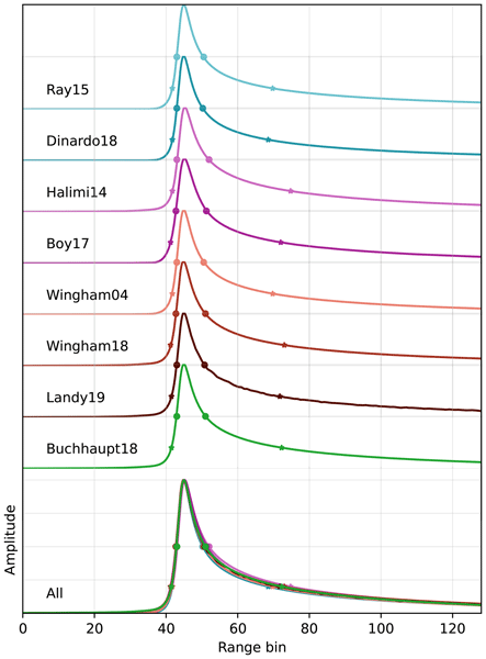
Radar altimeters measure ice-sheet elevation and sea-ice thickness. To improve their accuracy, we developed a model that simulates altimeter waveforms based on the physical properties of snow and sea ice. It computes the power, time, and Doppler shift of radar echoes as waves travel to the surface, interact with snow and ice, and return to the satellite. The model was verified internally, validated against other models and applied in Antarctica using in-situ snow measurements.
Alek Petty, Christopher Cardinale, Michel Tsamados, William Gregory, and Alex Cabaj
Earth Syst. Sci. Data Discuss., https://doi.org/10.5194/essd-2026-700, https://doi.org/10.5194/essd-2026-700, 2026
Preprint under review for ESSD
Short summary
Short summary
We combine laser-altimeter measurements with daily passive-microwave estimates of thin ice using Gaussian-process regression. The resulting dataset provides complete daily Arctic sea ice thickness maps across seven winter growth seasons, substantially improving spatial and temporal coverage, particularly during autumn freeze-up. It also better represents thin ice and enables consistent estimates of Arctic sea ice volume.
Lian He, Xinning Peng, Yi Zhou, Fengming Hui, Zhuoqi Chen, Liangbing Chen, Xianwei Wang, and Xiao Cheng
Earth Syst. Sci. Data Discuss., https://doi.org/10.5194/essd-2026-626, https://doi.org/10.5194/essd-2026-626, 2026
Preprint under review for ESSD
Short summary
Short summary
This study presents the SYSU SnowDepth dataset (1978–2025), the longest pan-Arctic snow depth on sea ice record covering both first-year ice and multi-year ice. Derived from passive microwave sensors using a new algorithm incorporating GRV(37/19), snow density, and time factor, it was validated against independent observations. Accuracy was high with root-mean-error-square (RMSE) values ranging from ~3 to 17 cm, offering vital support for climate and sea ice modeling.
Ayush Prasad, Ioanna Merkouriadi, Aleksi Nummelin, Jack Landy, Arttu Jutila, and Glen E. Liston
EGUsphere, https://doi.org/10.5194/egusphere-2026-4727, https://doi.org/10.5194/egusphere-2026-4727, 2026
This preprint is open for discussion and under review for The Cryosphere (TC).
Short summary
Short summary
Snow on Arctic sea ice is blown by wind into uneven drifts around ridges, which affects how well we can measure the thickness of the ice from satellites. Numerical models can capture this but are far too slow to run across the whole Arctic. We trained a machine-learning model on detailed simulations of small patches of ice, then applied it across the Arctic using satellite measurements of how rough the ice surface is.
Jiasheng Shi, Taoyong Jin, and Weiping Jiang
EGUsphere, https://doi.org/10.5194/egusphere-2026-5063, https://doi.org/10.5194/egusphere-2026-5063, 2026
This preprint is open for discussion and under review for Ocean Science (OS).
Short summary
Short summary
Altimeter satellites have transformed our understanding of the ocean, but small-scale features represented by sea level anomaly observations can be weakened when observations are combined into maps. Using observations from the Surface Water and Ocean Topography mission, we characterized how ocean features change across space and time and used this information to improve mapping. The resulting maps better preserve small-scale features and provide improved estimates of ocean currents and energy.
Bingshi Liu, Xiancai Zou, Jiancheng Li, and Taoyong Jin
Earth Syst. Sci. Data Discuss., https://doi.org/10.5194/essd-2026-531, https://doi.org/10.5194/essd-2026-531, 2026
Preprint under review for ESSD
Short summary
Short summary
Arctic river discharge records are often short and discontinuous, making it difficult to understand long-term freshwater changes. We reconstructed monthly natural river discharge at 94 stations in the Eurasian Arctic from 1952 to 2025 using precipitation, air temperature, snow information, gravity satellite measurements, and river observations. The dataset agrees well with observations, reveals changes in yearly flow and seasonal timing, and provides a baseline for studying Arctic rivers.
Patrick C. Taylor, Armin Sorooshian, Rei Ueyama, Sebastian Schmidt, Ihab Abboud, Quincy Allison, Kevin Barry, Sebastian Becker, Holly A. Bender, Joseph R. Bennett, James B. Blair, Niklas Bohn, Linette Boisvert, Matthew D. Brown, Roelof Bruintjes, Anthony Bucholtz, Megan Buzanowicz, Brian Cairns, Filippo Calì Quaglia, Eduard Chemyakin, Bo Chen, Gao Chen, Hong Chen, Yu-Wen Chen, Zezhen Cheng, Swarup China, Dan Chirica, Yonghoon Choi, Peter Colarco, Brian Collister, Ewan Crosbie, Maurice J. Cross, Janet Daniels, Paul DeMott, Joshua P. DiGangi, Alcide Giorgio di Sarra, Glenn S. Diskin, Erica K. Dolinar, Eva-Lou Edwards, Samuel Ephraim, Nikolaos Evangeliou, Romanos Foskinis, Francesca Gallo, Lan Gao, José Luis Gómez-Amo, Daisy Gonzalez, Christine Groot Zwaaftink, Pawan Gupta, Ivan Heckman, Michael Hendrickson, Miguel Ricardo A. Hilario, Ken Hirata, Michelle Hofton, Andrew L. Holen, Ulas Im, Alia L. Khan, Ralph Kahn, Alexei V. Korolev, Sonia Kreidenweis, Thomas Krumpen, Nathan Kurtz, Leslie Lait, Bradley Lamkin, Jack Landy, Nurun Nahar Lata, Paul Lawson, Samuel LeBlanc, Sean Leavor, Jing Li, Thorsten Markus, Hal Maring, Andreas H. Massling, Camille Mavis, Flynn McGinnity, Kerry Meyer, Gabriel Mojica, Richard H. Moore, Parker Morris, Giovanni Muscari, Vikas Nataraja, Amin R. Nehrir, Athanasios Nenes, Edward P. Nowottnick, Matteo Ottaviani, Chelsea Parker, Ryan Patnaude, Michael Perez, Russell J. Perkins, Colten Peterson, Alek Petty, Stevie Phothisane, Chris Polashenski, Kerri A. Pratt, Kayla M. Preisler, John Prytherch, David Rabine, Jens Redemann, Ju-Mee Ryoo, Joseph S. Schlosser, Vanessa Selimovic, Michael A. Shook, Morgan Silverman, Henrik Skov, Alexander Smirnov, Cassidy Soloff, Amy Solomon, Snorre Stamnes, Azusa Takeishi, David R. Thompson, K. Lee Thornhill, Rachel Tilling, Michael Tjernström, Monica Tosco, Pedro C. Valdelomar, David Van Gilst, Jian Wang, Zhien Wang, Andrzej Wasilewski, Manfred Wendisch, Brent Wilder, Edward L. Winstead, Albert Wu, Peng Xian, Lauren M. Zamora, Jiaoshi Zhang, Lei Zhang, Lu Zhang, Luke Ziemba, and Paquita Zuidema
Earth Syst. Sci. Data Discuss., https://doi.org/10.5194/essd-2026-241, https://doi.org/10.5194/essd-2026-241, 2026
Preprint under review for ESSD
Short summary
Short summary
This article summarizes the data sets collected during the Arctic Radiation Cloud aerosol Sea ice Interaction eXperiment (ARCSIX), NASA's most comprehensive Arctic field campaign to date. The overarching goal was to quantify the contributions of surface, clouds, aerosol particles, and precipitation to summer sea ice melt. This paper describes the ARCSIX implementation including the flight strategy, instruments, complementary data sets, access, and usage details.
Elie René-Bazin, Michel Tsamados, Sabrina Sofea Binti Aliff Raziuddin, Joel Perez Ferrer, Tudor Suciu, Carmen Nab, Chamkaur Ghag, Harry Heorton, Rosemary Willatt, Jack Landy, Matthew Fox, and Thomas Bodin
The Cryosphere, 20, 3913–3932, https://doi.org/10.5194/tc-20-3913-2026, https://doi.org/10.5194/tc-20-3913-2026, 2026
Short summary
Short summary
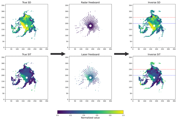
This paper introduces a new statistical approach to retrieve ice and snow depth over the Arctic Ocean, using satellite altimeters measurements. We demonstrate the ability of this method to compute efficiently the sea ice thickness and the snow depth over the Arctic, without major assumptions on the snow. In addition to the ice and snow depth, this approach is efficient to study the penetration of radar and laser pulses, paving the way for further research in satellite altimetry.
Chengyan Liu, Zhaomin Wang, Dake Chen, Xianxian Han, Hengling Leng, Xi Liang, Liangjun Yan, Xiang Li, Craig Stevens, Andrew McC. Hogg, Kazuya Kusahara, Kaihe Yamazaki, Kay I. Ohshima, Meng Zhou, Xiao Cheng, Dongxiao Wang, Changming Dong, Jiping Liu, Qinghua Yang, Xichen Li, Ruibo Lei, Minghu Ding, Zhaoru Zhang, Dujuan Kang, Di Qi, Tongya Liu, Jihai Dong, Lu An, Ru Chen, Tong Zhang, Xiaoming Hu, Bo Han, Haibo Bi, Qi Shu, Longjiang Mu, Shiming Xu, Hu Yang, Hailong Liu, Tingfeng Dou, Zhixuan Feng, Lei Zheng, Xueyuan Tang, Guitao Shi, Yongqing Cai, Bingrui Li, Yang Wu, Xia Lin, Wenjin Sun, Yu Liu, Kai Yu, Yu Zhang, Weizeng Shao, Xiaoyu Wang, Shaojun Zheng, Chengyi Yuan, Chunxia Zhou, Jian Liu, Yang Liu, Yue Xia, Xiaoyu Pan, Jiabao Zeng, Kechen Liu, Jiahao Fan, Chen Cheng, and Qi Li
Geosci. Model Dev., 19, 2985–3033, https://doi.org/10.5194/gmd-19-2985-2026, https://doi.org/10.5194/gmd-19-2985-2026, 2026
Short summary
Short summary
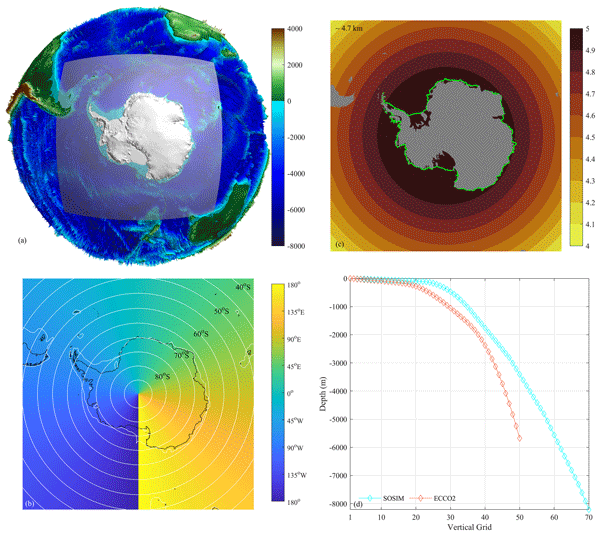
We developed a high-resolution computer model to simulate how the ocean, sea ice, and ice shelves interact around Antarctica. This helps us understand their critical role in global climate and sea-level rise. Our model successfully captures essential features like major currents and seasonal ice changes. Despite some remaining biases, it provides a useful tool for predicting future changes in this vital and rapidly evolving region.
Alistair Duffey, Walker Lee, Lauren Wheeler, Peter Irvine, Benjamin Wagman, Matthew Henry, Daniele Visioni, Michel Tsamados, and Douglas MacMartin
Earth Syst. Dynam., 17, 353–385, https://doi.org/10.5194/esd-17-353-2026, https://doi.org/10.5194/esd-17-353-2026, 2026
Short summary
Short summary
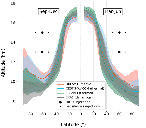
Adding a layer of reflective particles high in the atmosphere is one suggested way of cooling the planet and reducing the impacts of climate change. This technique might be less logistically difficult in the high latitudes, because the material could be released at lower altitude there. Here, we use new simulations in three earth system models to assess how this form of intervention, High-Latitude Low-Altitude Stratospheric Aerosol Injection (HiLLA-SAI), would impact the global climate.
Catherine Taelman, Jack Landy, Robbie Mallett, and Polona Itkin
EGUsphere, https://doi.org/10.5194/egusphere-2026-1662, https://doi.org/10.5194/egusphere-2026-1662, 2026
Short summary
Short summary
Arctic sea ice thickness is commonly estimated using radar measurements from satellites. This technique assumes that the snow on sea ice is 'invisible' to the radar signals. We studied if this assumption is valid and found that the radar measurements work well in cold conditions, when air temperatures are below –10 °C. However, the radar measurements can overestimate ice thickness during warmer periods, especially if there is new snowfall and if the snow contains salt.
Nicholas Williams, Nicholas Byrne, Daniel Feltham, Peter Jan Van Leeuwen, Ross Bannister, David Schroeder, Isobel Lawrence, Lars Nerger, Jack Landy, and Geoffrey Dawson
EGUsphere, https://doi.org/10.5194/egusphere-2026-742, https://doi.org/10.5194/egusphere-2026-742, 2026
Short summary
Short summary
In this study we present three satellite era Arctic sea ice reanalyses, each assimilating different combinations of sea ice concentration and thickness observations. Results show that using year-round thickness observations substantially improves reanalysis compared to winter-only data. The best-performing reanalysis reveals a seasonally compensating bias cycle, suggesting errors in ice growth, leads, refreezing, marginal ice zone dynamics, redistribution, and melt timing mask model errors.
Anne Braakmann-Folgmann, Jack C. Landy, Geoffrey Dawson, and Robert Ricker
The Cryosphere, 20, 905–929, https://doi.org/10.5194/tc-20-905-2026, https://doi.org/10.5194/tc-20-905-2026, 2026
Short summary
Short summary
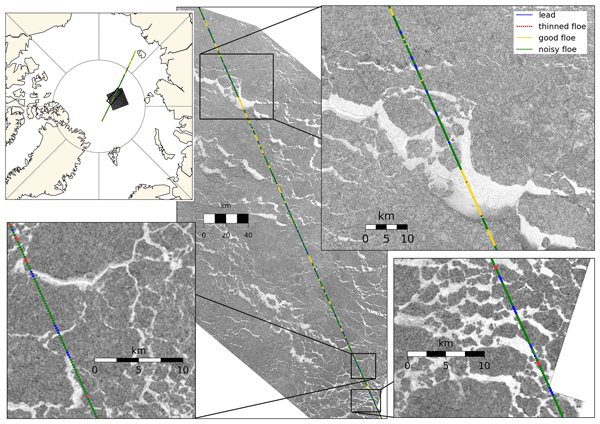
To calculate sea ice thickness from altimetry, returns from ice and leads need to be differentiated. During summer, melt ponds complicate this task, as they resemble leads. In this study, we improve a previously suggested neural network classifier by expanding the training dataset fivefold, tuning the network architecture and introducing an additional class for thinned floes. We show that this increases the accuracy from 77 ± 5 % to 84 ± 2 % and that more leads are found.
Valentin Ludwig, Caroline Ribere, Sara Fleury, Christian Haas, Michel Tsamados, Mahmoud El Hajj, Jerome Bouffard, Michele Scagliola, Marion Bocquet, Eric de Boisseson, Vincent Boulenger, Guillaume Boutin, Laurence Connor, Léo Edel, Stefan Hendricks, Ferran Hernández Macià, Marcus Huntemann, Lars Kaleschke, Frank Kauker, Jack Landy, Tom Megain, Alek Petty, Till Soya Rasmussen, Mads Hvid Ribergaard, Robert Ricker, Axel Schweiger, Hoyeon Shi, Xiangshan Tian-Kunze, Donghui Yi, and Alessandro Di Bella
EGUsphere, https://doi.org/10.5194/egusphere-2025-6201, https://doi.org/10.5194/egusphere-2025-6201, 2026
Short summary
Short summary
Our paper compares Arctic sea-ice thickness datasets from models, reanalyses, satellite-only, and multi-product sources. We validate them against Beaufort Sea reference data, compare large-scale products, and analyse time series. Cross-product biases range from 0.2–0.4 m, RMSDs from 0.4–0.9 m, and correlations from 0.5–0.8. We find no 2010–2023 trend, but 1995–2023 thinning of ~ 0.5 m in November and ~ 0.3 m in March.
Jack C. Landy, Claude de Rijke-Thomas, Carmen Nab, Isobel Lawrence, Isolde A. Glissenaar, Robbie D. C. Mallett, Renée M. Fredensborg Hansen, Alek Petty, Michel Tsamados, Amy R. Macfarlane, and Anne Braakmann-Folgmann
The Cryosphere, 20, 183–208, https://doi.org/10.5194/tc-20-183-2026, https://doi.org/10.5194/tc-20-183-2026, 2026
Short summary
Short summary
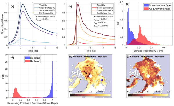
In this study, we use three satellites to test the planned remote sensing approach of the upcoming mission Copernicus Polar Ice and Snow Topography Altimeter (CRISTAL) over sea ice and that its dual radars will accurately measure the heights of the top and base of snow sitting atop floating sea ice floes. Our results suggest that CRISTAL's dual radars will not necessarily measure the snow top and base under all conditions. We find that accurate height measurements depend more on surface roughness than on snow properties, as is commonly assumed.
Stephen E. L. Howell, Alex Cabaj, David G. Babb, Jack C. Landy, Jackie Dawson, Mallik Mahmud, and Mike Brady
The Cryosphere, 19, 6711–6725, https://doi.org/10.5194/tc-19-6711-2025, https://doi.org/10.5194/tc-19-6711-2025, 2025
Short summary
Short summary
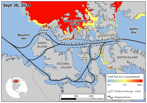
The Northwest Passage provides a shorter transit route connecting the Atlantic Ocean to the Pacific Ocean but ever-present sea ice has prevented its practical navigation. Sea ice area in the northern route of the Northwest Passage on September 30, 2024 fell to a minimum of 4×10³ km2 or ~3% of its total area, the lowest ice area observed since 1960. This paper describes the unique processes that contributed to the record low sea ice area in the northern route of the Northwest Passage in 2024.
Guokun Lyu, Longjiang Mu, Armin Koehl, Ruibo Lei, Xi Liang, and Chuanyu Liu
Geosci. Model Dev., 18, 9451–9468, https://doi.org/10.5194/gmd-18-9451-2025, https://doi.org/10.5194/gmd-18-9451-2025, 2025
Short summary
Short summary
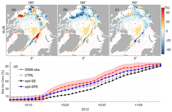
In the sea ice-ocean models, errors in the parameters and missing spatiotemporal variations contribute to the deviations between the simulations and the observations. We extended an adjoint method to optimize spatiotemporally varying parameters together with the atmosphere forcing and the initial conditions using satellite and in-situ observations. Seasonally, this scheme demonstrates a more prominent advantage in mid-autumn and show great potential for accurately reproducing the Arctic changes.
Siqi Liu, Shiming Xu, Wenkai Guo, Yanfei Fan, Lu Zhou, Jack Landy, Malin Johansson, Weixin Zhu, and Alek Petty
The Cryosphere, 19, 5175–5199, https://doi.org/10.5194/tc-19-5175-2025, https://doi.org/10.5194/tc-19-5175-2025, 2025
Short summary
Short summary
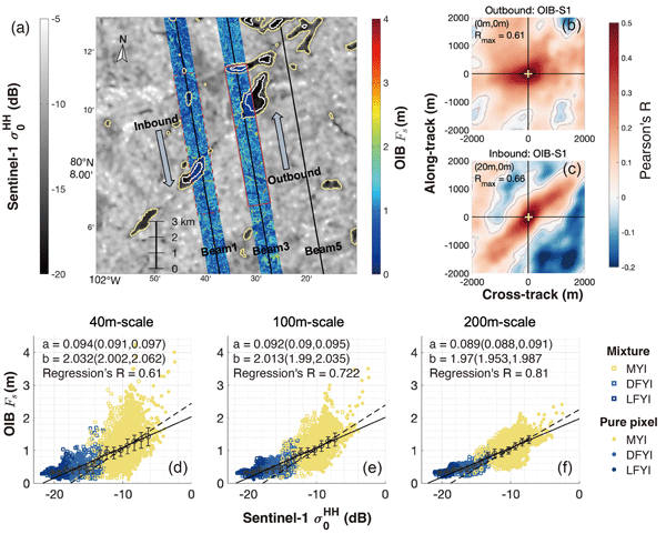
In this study, we explore the potential of using synthetic aperture radars (SAR) to predict the sea ice height measurements by the airborne campaign of Operation IceBridge. In particular, we predict the meter-scale sea ice height with the statistical relationship between the two, overcoming the resolution limitation of SAR images from Sentinel-1 satellites. The prediction and ice drift correction algorithms can be applied to the extrapolation of ICESat-2 measurements in the Arctic region.
Isolde Glissenaar, Klaas Folkert Boersma, Isidora Anglou, Pieter Rijsdijk, Tijl Verhoelst, Steven Compernolle, Gaia Pinardi, Jean-Christopher Lambert, Michel Van Roozendael, and Henk Eskes
Earth Syst. Sci. Data, 17, 4627–4650, https://doi.org/10.5194/essd-17-4627-2025, https://doi.org/10.5194/essd-17-4627-2025, 2025
Short summary
Short summary
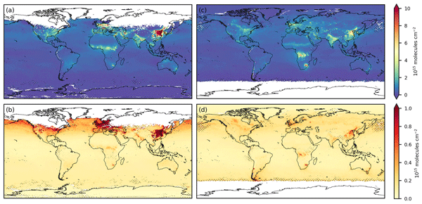
We developed a new global dataset of nitrogen dioxide (NO2) levels in the lower atmosphere, using data from TROPOMI for 2018–2021. This dataset offers improved accuracy and detail compared to earlier versions, meeting high international standards for climate data. By refining how measurement errors are calculated and reduced over time and space, we provide clearer insights into pollution patterns. This work supports better air quality monitoring and informs actions to address pollution globally.
Fanyi Zhang, Ruibo Lei, Meng Qu, Na Li, Ying Chen, and Xiaoping Pang
The Cryosphere, 19, 3065–3087, https://doi.org/10.5194/tc-19-3065-2025, https://doi.org/10.5194/tc-19-3065-2025, 2025
Short summary
Short summary
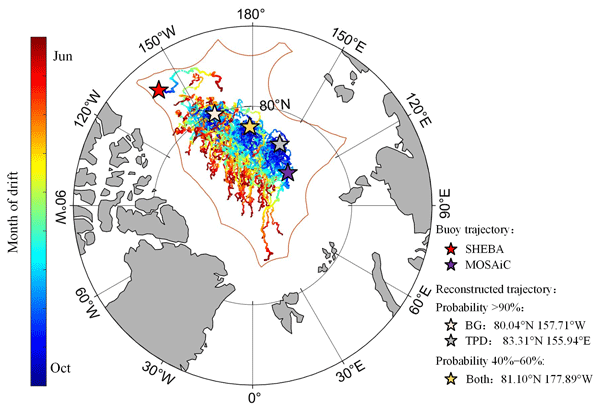
We reconstructed sea ice drift trajectories and identified optimal deployment areas for Lagrangian observations in the central Arctic Ocean. The trajectories revealed a preference for ice advection towards the Transpolar Drift region over the Beaufort Gyre, with endpoints influenced by large-scale atmospheric circulation patterns. This study provides critical support for the planning and implementation of Lagrangian observations relying on ice floes in the central Arctic Ocean under changing environmental conditions.
Suvarna Fadnavis, Yasin Elshorbany, Jerald Ziemke, Brice Barret, Alexandru Rap, P. R. Satheesh Chandran, Richard J. Pope, Vijay Sagar, Domenico Taraborrelli, Eric Le Flochmoen, Juan Cuesta, Catherine Wespes, Folkert Boersma, Isolde Glissenaar, Isabelle De Smedt, Michel Van Roozendael, Hervé Petetin, and Isidora Anglou
Atmos. Chem. Phys., 25, 8229–8254, https://doi.org/10.5194/acp-25-8229-2025, https://doi.org/10.5194/acp-25-8229-2025, 2025
Short summary
Short summary
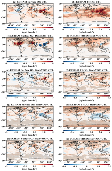
Satellites and model simulations show enhancement in tropospheric ozone, which is highly impacted by human-produced nitrous oxides compared to volatile organic compounds. The increased amount of ozone enhances ozone radiative forcing. The ozone enhancement and associated radiative forcing are the highest over South and East Asia. The emissions of nitrous oxides show a higher influence on shifting ozone photochemical regimes than volatile organic compounds.
Lianjun Yang, Taoyong Jin, and Weiping Jiang
Earth Syst. Sci. Data, 17, 2793–2807, https://doi.org/10.5194/essd-17-2793-2025, https://doi.org/10.5194/essd-17-2793-2025, 2025
Short summary
Short summary
Storm surges (SSs) cause massive loss of life and property in coastal areas each year. High-spatial-resolution and long-term SS records are important for assessing such events. However, tide gauges can provide limited SS information due to sparse and uneven distributions. Based on artificial intelligence technology and tide gauges, a high-spatial-coverage SS dataset was generated for the period from 1940 to 2020, which can provide possible alternative support for deepening our understanding of SSs.
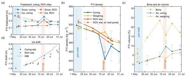
Evgenii Salganik, Odile Crabeck, Niels Fuchs, Nils Hutter, Philipp Anhaus, and Jack Christopher Landy
The Cryosphere, 19, 1259–1278, https://doi.org/10.5194/tc-19-1259-2025, https://doi.org/10.5194/tc-19-1259-2025, 2025
Short summary
Short summary
To measure Arctic ice thickness, we often check how much ice sticks out of the water. This method depends on knowing the ice's density, which drops significantly in summer. Our study, validated with sonar and laser data, shows that these seasonal changes in density can complicate melt measurements. We stress the importance of considering these density changes for more accurate ice thickness readings.
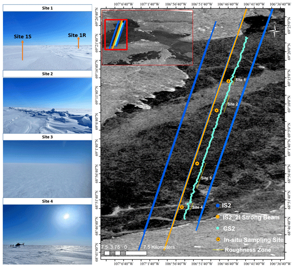
Monojit Saha, Julienne Stroeve, Dustin Isleifson, John Yackel, Vishnu Nandan, Jack Christopher Landy, and Hoi Ming Lam
The Cryosphere, 19, 325–346, https://doi.org/10.5194/tc-19-325-2025, https://doi.org/10.5194/tc-19-325-2025, 2025
Short summary
Short summary
Snow on sea ice is vital for near-shore sea ice geophysical and biological processes. Past studies have measured snow depths using the satellite altimeters Cryosat-2 and ICESat-2 (Cryo2Ice), but estimating sea surface height from leadless landfast sea ice remains challenging. Snow depths from Cryo2Ice are compared to in situ data after adjusting for tides. Realistic snow depths are retrieved, but differences in roughness, satellite footprints, and snow geophysical properties are identified.
Yi Zhou, Xianwei Wang, Ruibo Lei, Arttu Jutila, Donald K. Perovich, Luisa von Albedyll, Dmitry V. Divine, Yu Zhang, and Christian Haas
EGUsphere, https://doi.org/10.5194/egusphere-2024-2821, https://doi.org/10.5194/egusphere-2024-2821, 2024
Preprint archived
Short summary
Short summary
This study examines how the bulk density of Arctic sea ice varies seasonally, a factor often overlooked in satellite measurements of sea ice thickness. From October to April, we found significant seasonal variations in sea ice bulk density at different spatial scales using direct observations as well as airborne and satellite data. New models were then developed to indirectly predict sea ice bulk density. This advance can improve our ability to monitor changes in Arctic sea ice.
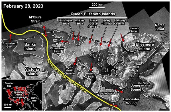
Stephen E. L. Howell, David G. Babb, Jack C. Landy, Isolde A. Glissenaar, Kaitlin McNeil, Benoit Montpetit, and Mike Brady
The Cryosphere, 18, 2321–2333, https://doi.org/10.5194/tc-18-2321-2024, https://doi.org/10.5194/tc-18-2321-2024, 2024
Short summary
Short summary
The CAA serves as both a source and a sink for sea ice from the Arctic Ocean, while also exporting sea ice into Baffin Bay. It is also an important region with respect to navigating the Northwest Passage. Here, we quantify sea ice transport and replenishment across and within the CAA from 2016 to 2022. We also provide the first estimates of the ice area and volume flux within the CAA from the Queen Elizabeth Islands to Parry Channel, which spans the central region of the Northwest Passage.
Yi Zhou, Xianwei Wang, Ruibo Lei, Luisa von Albedyll, Donald K. Perovich, Yu Zhang, and Christian Haas
EGUsphere, https://doi.org/10.5194/egusphere-2024-1240, https://doi.org/10.5194/egusphere-2024-1240, 2024
Preprint archived
Short summary
Short summary
This study examines how the density of Arctic sea ice varies seasonally, a factor often overlooked in satellite measurements of sea ice thickness. From October to April, using direct observations and satellite data, we found that sea ice density decreases significantly until mid-January due to increased porosity as the ice ages, and then stabilizes until April. We then developed new models to estimate sea ice density. This advance can improve our ability to monitor changes in Arctic sea ice.
Guodong Chen, Weiping Jiang, Zhijie Zhang, Taoyong Jin, and Dawei Li
EGUsphere, https://doi.org/10.5194/egusphere-2023-3030, https://doi.org/10.5194/egusphere-2023-3030, 2024
Preprint archived
Short summary
Short summary
This paper attempts to determine Arctic mean sea surface and sea level change by combining ICESat-2 and CryoSat-2 data. Our results show that the SSH flag identified in ATL07 may be too strict, resulting in a small number of lead identifications. Combining the two missions can obtain sea surface height with higher accuracy and coverage in the Arctic. The results are helpful for the study of sea level, sea ice, and the accuracy of ICESat-2 and CryoSat-2 data in the Arctic.
Miao Yu, Peng Lu, Matti Leppäranta, Bin Cheng, Ruibo Lei, Bingrui Li, Qingkai Wang, and Zhijun Li
The Cryosphere, 18, 273–288, https://doi.org/10.5194/tc-18-273-2024, https://doi.org/10.5194/tc-18-273-2024, 2024
Short summary
Short summary
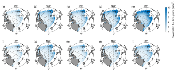
Variations in Arctic sea ice are related not only to its macroscale properties but also to its microstructure. Arctic ice cores in the summers of 2008 to 2016 were used to analyze variations in the ice inherent optical properties related to changes in the ice microstructure. The results reveal changing ice microstructure greatly increased the amount of solar radiation transmitted to the upper ocean even when a constant ice thickness was assumed, especially in marginal ice zones.
Alistair Duffey, Robbie Mallett, Peter J. Irvine, Michel Tsamados, and Julienne Stroeve
Earth Syst. Dynam., 14, 1165–1169, https://doi.org/10.5194/esd-14-1165-2023, https://doi.org/10.5194/esd-14-1165-2023, 2023
Short summary
Short summary
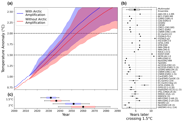
The Arctic is warming several times faster than the rest of the planet. Here, we use climate model projections to quantify for the first time how this faster warming in the Arctic impacts the timing of crossing the 1.5 °C and 2 °C thresholds defined in the Paris Agreement. We show that under plausible emissions scenarios that fail to meet the Paris 1.5 °C target, a hypothetical world without faster warming in the Arctic would breach that 1.5 °C target around 5 years later.
Fanyi Zhang, Ruibo Lei, Mengxi Zhai, Xiaoping Pang, and Na Li
The Cryosphere, 17, 4609–4628, https://doi.org/10.5194/tc-17-4609-2023, https://doi.org/10.5194/tc-17-4609-2023, 2023
Short summary
Short summary
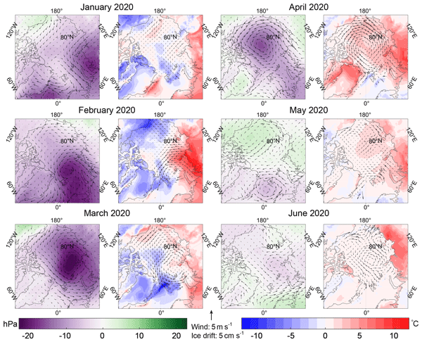
Atmospheric circulation anomalies lead to high Arctic sea ice outflow in winter 2020, causing heavy ice conditions in the Barents–Greenland seas, subsequently impeding the sea surface temperature warming. This suggests that the winter–spring Arctic sea ice outflow can be considered a predictor of changes in sea ice and other marine environmental conditions in the Barents–Greenland seas, which could help to improve our understanding of the physical connections between them.
Geoffrey J. Dawson and Jack C. Landy
The Cryosphere, 17, 4165–4178, https://doi.org/10.5194/tc-17-4165-2023, https://doi.org/10.5194/tc-17-4165-2023, 2023
Short summary
Short summary
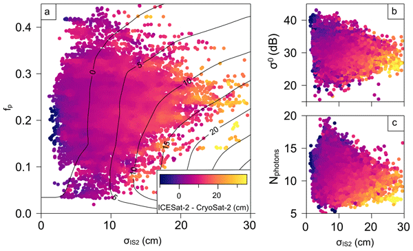
In this study, we compared measurements from CryoSat-2 and ICESat-2 over Arctic summer sea ice to understand any possible biases between the two satellites. We found that there is a difference when we measure elevation over summer sea ice using CryoSat-2 and ICESat-2, and this is likely due to surface melt ponds. The differences we found were in good agreement with theoretical predictions, and this work will be valuable for summer sea ice thickness measurements from both altimeters.
Alexander Mchedlishvili, Christof Lüpkes, Alek Petty, Michel Tsamados, and Gunnar Spreen
The Cryosphere, 17, 4103–4131, https://doi.org/10.5194/tc-17-4103-2023, https://doi.org/10.5194/tc-17-4103-2023, 2023
Short summary
Short summary
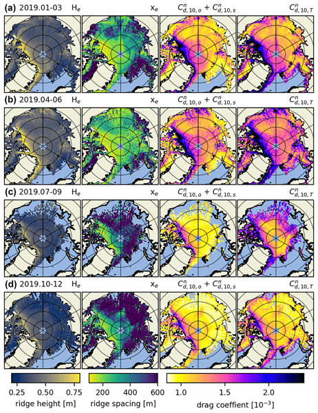
In this study we looked at sea ice–atmosphere drag coefficients, quantities that help with characterizing the friction between the atmosphere and sea ice, and vice versa. Using ICESat-2, a laser altimeter that measures elevation differences by timing how long it takes for photons it sends out to return to itself, we could map the roughness, i.e., how uneven the surface is. From roughness we then estimate drag force, the frictional force between sea ice and the atmosphere, across the Arctic.
Isolde A. Glissenaar, Jack C. Landy, David G. Babb, Geoffrey J. Dawson, and Stephen E. L. Howell
The Cryosphere, 17, 3269–3289, https://doi.org/10.5194/tc-17-3269-2023, https://doi.org/10.5194/tc-17-3269-2023, 2023
Short summary
Short summary
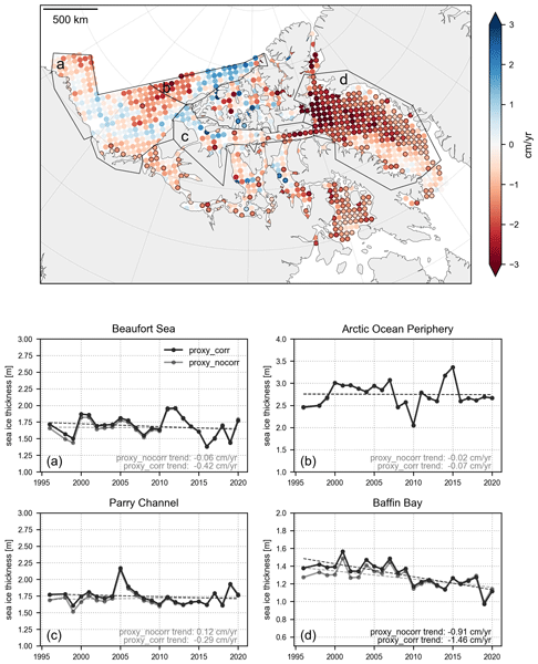
Observations of large-scale ice thickness have unfortunately only been available since 2003, a short record for researching trends and variability. We generated a proxy for sea ice thickness in the Canadian Arctic for 1996–2020. This is the longest available record for large-scale sea ice thickness available to date and the first record reliably covering the channels between the islands in northern Canada. The product shows that sea ice has thinned by 21 cm over the 25-year record in April.
Ying Chen, Ruibo Lei, Xi Zhao, Shengli Wu, Yue Liu, Pei Fan, Qing Ji, Peng Zhang, and Xiaoping Pang
Earth Syst. Sci. Data, 15, 3223–3242, https://doi.org/10.5194/essd-15-3223-2023, https://doi.org/10.5194/essd-15-3223-2023, 2023
Short summary
Short summary
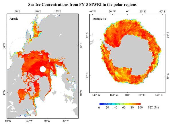
The sea ice concentration product derived from the Microwave Radiation Image sensors on board the FengYun-3 satellites can reasonably and independently identify the seasonal and long-term changes of sea ice, as well as extreme cases of annual maximum and minimum sea ice extent in polar regions. It is comparable with other sea ice concentration products and applied to the studies of climate and marine environment.

Vishnu Nandan, Rosemary Willatt, Robbie Mallett, Julienne Stroeve, Torsten Geldsetzer, Randall Scharien, Rasmus Tonboe, John Yackel, Jack Landy, David Clemens-Sewall, Arttu Jutila, David N. Wagner, Daniela Krampe, Marcus Huntemann, Mallik Mahmud, David Jensen, Thomas Newman, Stefan Hendricks, Gunnar Spreen, Amy Macfarlane, Martin Schneebeli, James Mead, Robert Ricker, Michael Gallagher, Claude Duguay, Ian Raphael, Chris Polashenski, Michel Tsamados, Ilkka Matero, and Mario Hoppmann
The Cryosphere, 17, 2211–2229, https://doi.org/10.5194/tc-17-2211-2023, https://doi.org/10.5194/tc-17-2211-2023, 2023
Short summary
Short summary
We show that wind redistributes snow on Arctic sea ice, and Ka- and Ku-band radar measurements detect both newly deposited snow and buried snow layers that can affect the accuracy of snow depth estimates on sea ice. Radar, laser, meteorological, and snow data were collected during the MOSAiC expedition. With frequent occurrence of storms in the Arctic, our results show that
wind-redistributed snow needs to be accounted for to improve snow depth estimates on sea ice from satellite radars.
Yi Zhou, Yu Zhang, Changsheng Chen, Lele Li, Danya Xu, Robert C. Beardsley, and Weizeng Shao
The Cryosphere Discuss., https://doi.org/10.5194/tc-2023-40, https://doi.org/10.5194/tc-2023-40, 2023
Revised manuscript not accepted
Short summary
Short summary
This study used an improved retracking algorithm, considered the corrected radar penetration rates, and included the new snow depth from the Feng Yun-3B satellite to enhance the accuracy of Arctic sea ice thickness derived from the CryoSat-2 satellite. This comprehensive optimization was the first to improve the sea ice thickness retrieval. Compared with the sea ice product derived by the Alfred Wegener Institute, the optimization cases could successfully reduce the errors above 20 %.
Na Li, Ruibo Lei, Petra Heil, Bin Cheng, Minghu Ding, Zhongxiang Tian, and Bingrui Li
The Cryosphere, 17, 917–937, https://doi.org/10.5194/tc-17-917-2023, https://doi.org/10.5194/tc-17-917-2023, 2023
Short summary
Short summary
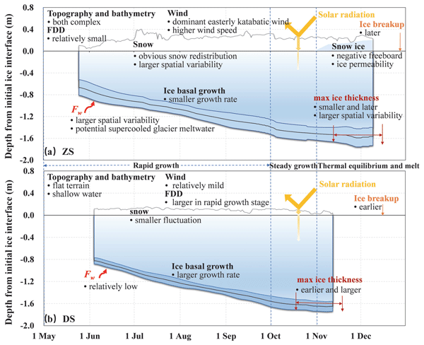
The observed annual maximum landfast ice (LFI) thickness off Zhongshan (Davis) was 1.59±0.17 m (1.64±0.08 m). Larger interannual and local spatial variabilities for the seasonality of LFI were identified at Zhongshan, with the dominant influencing factors of air temperature anomaly, snow atop, local topography and wind regime, and oceanic heat flux. The variability of LFI properties across the study domain prevailed at interannual timescales, over any trend during the recent decades.
Ruibo Lei, Mario Hoppmann, Bin Cheng, Marcel Nicolaus, Fanyi Zhang, Benjamin Rabe, Long Lin, Julia Regnery, and Donald K. Perovich
The Cryosphere Discuss., https://doi.org/10.5194/tc-2023-25, https://doi.org/10.5194/tc-2023-25, 2023
Manuscript not accepted for further review
Short summary
Short summary
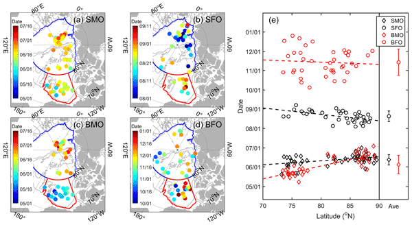
To characterize the freezing and melting of different types of sea ice, we deployed four IMBs during the MOSAiC second drift. The drifting pattern, together with a large snow accumulation, relatively warm air temperatures, and a rapid increase in oceanic heat close to Fram Strait, determined the seasonal evolution of the ice mass balance. The refreezing of ponded ice and voids within the unconsolidated ridges amplifies the anisotropy of the heat exchange between the ice and the atmosphere/ocean.
Long Lin, Ruibo Lei, Mario Hoppmann, Donald K. Perovich, and Hailun He
The Cryosphere, 16, 4779–4796, https://doi.org/10.5194/tc-16-4779-2022, https://doi.org/10.5194/tc-16-4779-2022, 2022
Short summary
Short summary
Ice mass balance observations indicated that average basal melt onset was comparable in the central Arctic Ocean and approximately 17 d earlier than surface melt in the Beaufort Gyre. The average onset of basal growth lagged behind the surface of the pan-Arctic Ocean for almost 3 months. In the Beaufort Gyre, both drifting-buoy observations and fixed-point observations exhibit a trend towards earlier basal melt onset, which can be ascribed to the earlier warming of the surface ocean.
Jiasheng Shi, Taoyong Jin, Mao Zhou, Xiangcheng Wan, and Weiping Jiang
EGUsphere, https://doi.org/10.5194/egusphere-2022-1018, https://doi.org/10.5194/egusphere-2022-1018, 2022
Preprint withdrawn
Short summary
Short summary
SWOT has significant potential for detecting mesoscale eddies, but the detecting method, which is used for nadir altimeters, may be not optimal. We propose to improve the method based on the spatial and temporal features of SWOT, to reduce the long-wavelength errors and enhance the high spatial features. The accuracy of gridded results are improved especially when the number of observations is limited. The reconstruction and detected temporal scales of mesoscale eddy variations is also enhanced.
Julienne Stroeve, Vishnu Nandan, Rosemary Willatt, Ruzica Dadic, Philip Rostosky, Michael Gallagher, Robbie Mallett, Andrew Barrett, Stefan Hendricks, Rasmus Tonboe, Michelle McCrystall, Mark Serreze, Linda Thielke, Gunnar Spreen, Thomas Newman, John Yackel, Robert Ricker, Michel Tsamados, Amy Macfarlane, Henna-Reetta Hannula, and Martin Schneebeli
The Cryosphere, 16, 4223–4250, https://doi.org/10.5194/tc-16-4223-2022, https://doi.org/10.5194/tc-16-4223-2022, 2022
Short summary
Short summary
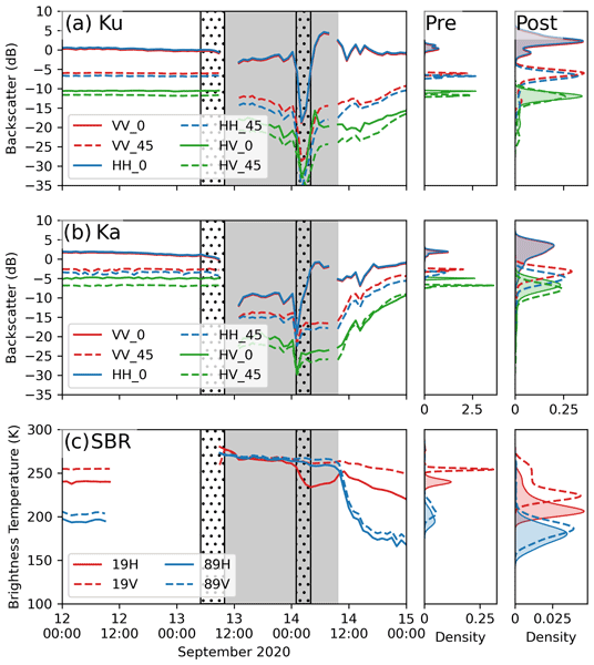
Impacts of rain on snow (ROS) on satellite-retrieved sea ice variables remain to be fully understood. This study evaluates the impacts of ROS over sea ice on active and passive microwave data collected during the 2019–20 MOSAiC expedition. Rainfall and subsequent refreezing of the snowpack significantly altered emitted and backscattered radar energy, laying important groundwork for understanding their impacts on operational satellite retrievals of various sea ice geophysical variables.
Qiang Zhang, Qiangqiang Yuan, Taoyong Jin, Meiping Song, and Fujun Sun
Earth Syst. Sci. Data, 14, 4473–4488, https://doi.org/10.5194/essd-14-4473-2022, https://doi.org/10.5194/essd-14-4473-2022, 2022
Short summary
Short summary
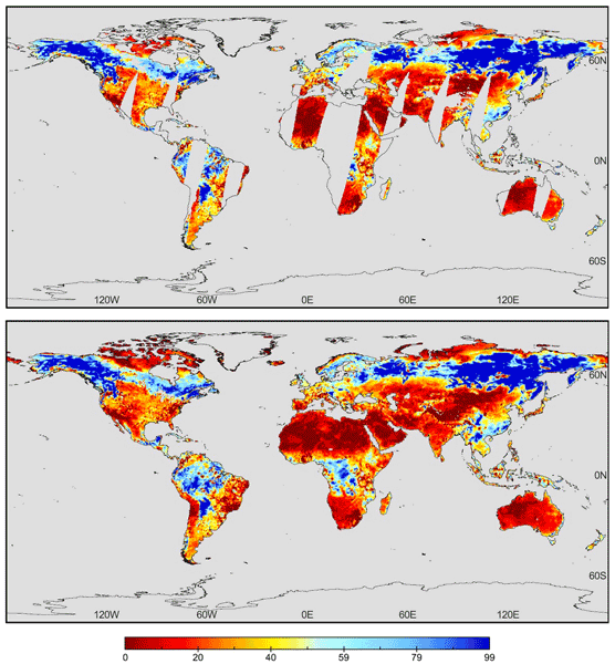
Compared to previous seamless global daily soil moisture (SGD-SM 1.0) products, SGD-SM 2.0 enlarges the temporal scope from 2002 to 2022. By fusing auxiliary precipitation information with the long short-term memory convolutional neural network (LSTM-CNN) model, SGD-SM 2.0 can consider sudden extreme weather conditions for 1 d in global daily soil moisture products and is significant for full-coverage global daily hydrologic monitoring, rather than averaging monthly–quarterly–yearly results.
William Gregory, Julienne Stroeve, and Michel Tsamados
The Cryosphere, 16, 1653–1673, https://doi.org/10.5194/tc-16-1653-2022, https://doi.org/10.5194/tc-16-1653-2022, 2022
Short summary
Short summary
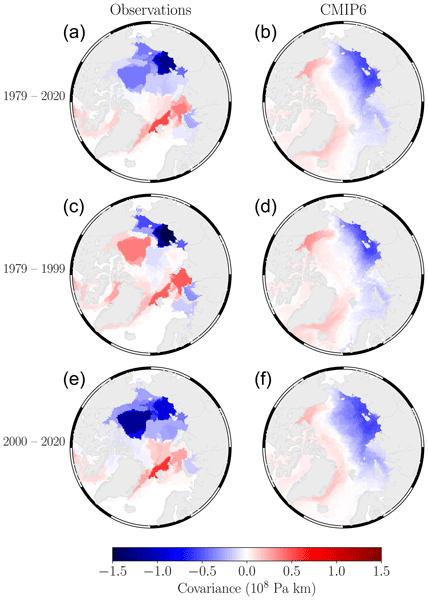
This research was conducted to better understand how coupled climate models simulate one of the large-scale interactions between the atmosphere and Arctic sea ice that we see in observational data, the accurate representation of which is important for producing reliable forecasts of Arctic sea ice on seasonal to inter-annual timescales. With network theory, this work shows that models do not reflect this interaction well on average, which is likely due to regional biases in sea ice thickness.
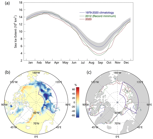
Yu Liang, Haibo Bi, Haijun Huang, Ruibo Lei, Xi Liang, Bin Cheng, and Yunhe Wang
The Cryosphere, 16, 1107–1123, https://doi.org/10.5194/tc-16-1107-2022, https://doi.org/10.5194/tc-16-1107-2022, 2022
Short summary
Short summary
A record minimum July sea ice extent, since 1979, was observed in 2020. Our results reveal that an anomalously high advection of energy and water vapor prevailed during spring (April to June) 2020 over regions with noticeable sea ice retreat. The large-scale atmospheric circulation and cyclones act in concert to trigger the exceptionally warm and moist flow. The convergence of the transport changed the atmospheric characteristics and the surface energy budget, thus causing a severe sea ice melt.
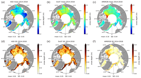
Florent Garnier, Sara Fleury, Gilles Garric, Jérôme Bouffard, Michel Tsamados, Antoine Laforge, Marion Bocquet, Renée Mie Fredensborg Hansen, and Frédérique Remy
The Cryosphere, 15, 5483–5512, https://doi.org/10.5194/tc-15-5483-2021, https://doi.org/10.5194/tc-15-5483-2021, 2021
Short summary
Short summary
Snow depth data are essential to monitor the impacts of climate change on sea ice volume variations and their impacts on the climate system. For that purpose, we present and assess the altimetric snow depth product, computed in both hemispheres from CryoSat-2 and SARAL satellite data. The use of these data instead of the common climatology reduces the sea ice thickness by about 30 cm over the 2013–2019 period. These data are also crucial to argue for the launch of the CRISTAL satellite mission.
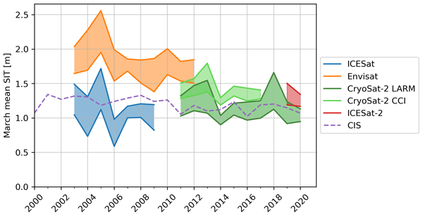
Isolde A. Glissenaar, Jack C. Landy, Alek A. Petty, Nathan T. Kurtz, and Julienne C. Stroeve
The Cryosphere, 15, 4909–4927, https://doi.org/10.5194/tc-15-4909-2021, https://doi.org/10.5194/tc-15-4909-2021, 2021
Short summary
Short summary
Scientists can estimate sea ice thickness using satellites that measure surface height. To determine the sea ice thickness, we also need to know the snow depth and density. This paper shows that the chosen snow depth product has a considerable impact on the findings of sea ice thickness state and trends in Baffin Bay, showing mean thinning with some snow depth products and mean thickening with others. This shows that it is important to better understand and monitor snow depth on sea ice.
Cited articles
Andersen, O. B., Rose, S. K., Abulaitijiang, A., Zhang, S., and Fleury, S.: The DTU21 global mean sea surface and first evaluation, Earth Syst. Sci. Data, 15, 4065–4075, https://doi.org/10.5194/essd-15-4065-2023, 2023.
Aylmer, J. R., Ferreira, D., and Feltham, D. L.: Impact of ocean heat transport on sea ice captured by a simple energy balance model, Commun. Earth Environ., 5, 406, https://doi.org/10.1038/s43247-024-01565-7, 2024.
Bagnardi, M., Kurtz, N. T., Petty, A. A., and Kwok, R.: Sea Surface Height Anomalies of the Arctic Ocean From ICESat‐2: A First Examination and Comparisons With CryoSat‐2, Geophys. Res. Lett., 48, https://doi.org/10.1029/2021GL093155, 2021.
Bateson, A. W., Feltham, D. L., Schröder, D., Hosekova, L., Ridley, J. K., and Aksenov, Y.: Impact of sea ice floe size distribution on seasonal fragmentation and melt of Arctic sea ice, The Cryosphere, 14, 403–428, https://doi.org/10.5194/tc-14-403-2020, 2020.
Breiman, L.: Random Forests, Mach. Learn., 45, 5–32, https://doi.org/10.1023/A:1010933404324, 2001.
Brunt, K. M., Smith, B. E., Sutterley, T. C., Kurtz, N. T., and Neumann, T. A.: Comparisons of Satellite and Airborne Altimetry With Ground‐Based Data From the Interior of the Antarctic Ice Sheet, Geophys. Res. Lett., 48, https://doi.org/10.1029/2020GL090572, 2021.
Buckley, E. M., Farrell, S. L., Herzfeld, U. C., Webster, M. A., Trantow, T., Baney, O. N., Duncan, K. A., Han, H., and Lawson, M.: Observing the evolution of summer melt on multiyear sea ice with ICESat-2 and Sentinel-2, The Cryosphere, 17, 3695–3719, https://doi.org/10.5194/tc-17-3695-2023, 2023.
Buckley, E. M., Horvat, C., and Yoosiri, P.: Sea ice concentration estimates from ICESat-2 linear ice fraction – Part 1: Multi-sensor comparison of sea ice concentration products, The Cryosphere, 19, 4805–4818, https://doi.org/10.5194/tc-19-4805-2025, 2025.
Chu, C.-Y., Henderson, D. J., and Parmeter, C. F.: On discrete Epanechnikov kernel functions, Comput. Stat. Data An., 116, 79–105, https://doi.org/10.1016/j.csda.2017.07.003, 2017.
Dandabathula, G., Roy, S., Ghatage, O., Bera, A. K., and Srivastav, S. K.: Determination of dust storm height using weak beam photons from ICESat-2 and relating with vertical wind profile, Atmos. Environ., 354, 121276, https://doi.org/10.1016/j.atmosenv.2025.121276, 2025.
Dawson, G., Landy, J., Tsamados, M., Komarov, A. S., Howell, S., Heorton, H., and Krumpen, T.: A 10-year record of Arctic summer sea ice freeboard from CryoSat-2, Remote Sens. Environ., 268, 112744, https://doi.org/10.1016/j.rse.2021.112744, 2022.
Duncan, K. and Farrell, S. L.: Determining Variability in Arctic Sea Ice Pressure Ridge Topography With ICESat‐2, Geophys. Res. Lett., 49, https://doi.org/10.1029/2022GL100272, 2022.
Farrell, S. L., Duncan, K., Buckley, E. M., Richter‐Menge, J., and Li, R.: Mapping Sea Ice Surface Topography in High Fidelity With ICESat‐2, Geophys. Res. Lett., 47, https://doi.org/10.1029/2020GL090708, 2020.
Fredensborg Hansen, R. M., Rinne, E., and Skourup, H.: Classification of Sea Ice Types in the Arctic by Radar Echoes from SARAL/AltiKa, Remote Sens., 13, 3183, https://doi.org/10.3390/rs13163183, 2021.
Herzfeld, U. C., Trantow, T. M., Han, H., Buckley, E., Farrell, S. L., and Lawson, M.: Automated Detection and Depth Determination of Melt Ponds on Sea Ice in ICESat-2 ATLAS Data – The Density-Dimension Algorithm for Bifurcating Sea-Ice Reflectors (DDA-Bifurcate-Seaice), IEEE Trans. Geosci. Remote Sens., 61, 1–22, https://doi.org/10.1109/TGRS.2023.3268073, 2023.
Kacimi, S. and Kwok, R.: Arctic Snow Depth, Ice Thickness, and Volume From ICESat‐2 and CryoSat‐2: 2018–2021, Geophys. Res. Lett., 49, https://doi.org/10.1029/2021GL097448, 2022.
Kacimi, S. and Kwok, R.: Two Decades of Arctic Sea-Ice Thickness from Satellite Altimeters: Retrieval Approaches and Record of Changes (2003–2023), Remote Sens., 16, 2983, https://doi.org/10.3390/rs16162983, 2024.
Koo, Y., Xie, H., Kurtz, N. T., Ackley, S. F., and Wang, W.: Sea ice surface type classification of ICESat-2 ATL07 data by using data-driven machine learning model: Ross Sea, Antarctic as an example, Remote Sens. Environ., 296, 113726, https://doi.org/10.1016/j.rse.2023.113726, 2023.
Koo, Y., Xie, H., Meier, W. N., Ackley, S. F., and Kurtz, N. T.: Detection of multi-year ex-fast ice in the Weddell Sea, Antarctica, using ICESat-2 satellite altimeter data, Remote Sens. Environ., 325, 114750, https://doi.org/10.1016/j.rse.2025.114750, 2025.
Kortum, K., Singha, S., and Spreen, G.: Sea ice freeboard extrapolation from ICESat-2 to Sentinel-1, The Cryosphere, 19, 4701–4714, https://doi.org/10.5194/tc-19-4701-2025, 2025.
Krabill, W. B., Abdalati, W., Frederick, E. B., Manizade, S. S., Martin, C. F., Sonntag, J. G., Swift, R. N., Thomas, R. H., and Yungel, J. G.: Aircraft laser altimetry measurement of elevation changes of the greenland ice sheet: technique and accuracy assessment, J. Geodyn., 34, 357–376, https://doi.org/10.1016/S0264-3707(02)00040-6, 2002.
Krumpen, T., Von Albedyll, L., Bünger, H. J., Castellani, G., Hartmann, J., Helm, V., Hendricks, S., Hutter, N., Landy, J. C., Lisovski, S., Lüpkes, C., Rohde, J., Suhrhoff, M., and Haas, C.: Smoother sea ice with fewer pressure ridges in a more dynamic Arctic, Nat. Clim. Chang., 15, 66–72, https://doi.org/10.1038/s41558-024-02199-5, 2025.
Kurtz, N. T. and Markus, T.: Satellite observations of Antarctic sea ice thickness and volume, J. Geophys. Res., 117, https://doi.org/10.1029/2012JC008141, 2012.
Kwok, R., Cunningham, G. F., Hoffmann, J., and Markus, T.: Testing the ice-water discrimination and freeboard retrieval algorithms for the ICESat-2 mission, Remote Sens. Environ., 183, 13–25, https://doi.org/10.1016/j.rse.2016.05.011, 2016.
Kwok, R., Kacimi, S., Markus, T., Kurtz, N. T., Studinger, M., Sonntag, J. G., Manizade, S. S., Boisvert, L. N., and Harbeck, J. P.: ICESat‐2 Surface Height and Sea Ice Freeboard Assessed With ATM Lidar Acquisitions From Operation IceBridge, Geophys. Res. Lett., 46, 11228–11236, https://doi.org/10.1029/2019GL084976, 2019a.
Kwok, R., Markus, T., Kurtz, N. T., Petty, A. A., Neumann, T. A., Farrell, S. L., Cunningham, G. F., Hancock, D. W., Ivanoff, A., and Wimert, J. T.: Surface Height and Sea Ice Freeboard of the Arctic Ocean From ICESat‐2: Characteristics and Early Results, J. Geophys. Res.-Oceans, 124, 6942–6959, https://doi.org/10.1029/2019JC015486, 2019b.
Kwok, R., Petty, A. A., Bagnardi, M., Kurtz, N. T., Cunningham, G. F., Ivanoff, A., and Kacimi, S.: Refining the sea surface identification approach for determining freeboards in the ICESat-2 sea ice products, The Cryosphere, 15, 821–833, https://doi.org/10.5194/tc-15-821-2021, 2021.
Kwok, R., Petty, A. A., Cunningham, G., Markus, T., Hancock, D., Ivanoff, A., Wimert, J., Bagnardi, M., Kurtz, N., and the ICESat-2 Science Team: ATLAS/ICESat-2 L3A Sea Ice Height, Version 6, NSIDC [data set], https://doi.org/10.5067/ATLAS/ATL07.006, 2023.
Kwok, R., Kurtz, N., Wimert, J., Petty, A., Cunningham, G., Markus, T., Hancock, D., Ivanoff, A., Bagnardi, M., Herzfeld, U., Trantow, T., and ICESat-2 Science Team: Ice, Cloud, and Land Elevation Satellite (ICESat-2) Project Algorithm Theoretical Basis Document (ATBD) for Sea Ice Products, version 7, https://doi.org/10.5067/KPMXUOH7TNIY, 2026.
Landy, J. C., Dawson, G. J., Tsamados, M., Bushuk, M., Stroeve, J. C., Howell, S. E. L., Krumpen, T., Babb, D. G., Komarov, A. S., Heorton, H. D. B. S., Belter, H. J., and Aksenov, Y.: A year-round satellite sea-ice thickness record from CryoSat-2, Nature, 609, 517–522, https://doi.org/10.1038/s41586-022-05058-5, 2022.
Laxon, S. W., Giles, K. A., Ridout, A. L., Wingham, D. J., Willatt, R., Cullen, R., Kwok, R., Schweiger, A., Zhang, J., Haas, C., Hendricks, S., Krishfield, R., Kurtz, N., Farrell, S., and Davidson, M.: CryoSat‐2 estimates of Arctic sea ice thickness and volume, Geophys. Res. Lett., 40, 732–737, https://doi.org/10.1002/grl.50193, 2013.
Light, B., Smith, M. M., Perovich, D. K., Webster, M. A., Holland, M. M., Linhardt, F., Raphael, I. A., Clemens-Sewall, D., Macfarlane, A. R., Anhaus, P., and Bailey, D. A.: Arctic sea ice albedo: Spectral composition, spatial heterogeneity, and temporal evolution observed during the MOSAiC drift, Elementa: Science of the Anthropocene, 10, 000103, https://doi.org/10.1525/elementa.2021.000103, 2022.
Liu, A., Yang, J., Bao, Q., Vitart, F., Liu, J., Liang, X., Lu, M., Kim, S.-J., Gong, D., Tian, Z., and Liu, H.: Assimilating summer sea ice thickness enhances predictions of Arctic sea ice and surrounding atmosphere within two months, npj Clim. Atmos. Sci., 8, 210, https://doi.org/10.1038/s41612-025-01050-8, 2025a.
Liu, Q., Babanin, A. V., Zieger, S., Young, I. R., and Guan, C.: Wind and Wave Climate in the Arctic Ocean as Observed by Altimeters, J. Climate, 29, 7957–7975, https://doi.org/10.1175/JCLI-D-16-0219.1, 2016.
Liu, W.: Along-track data accompanying the article “Year-Round High-Resolution Sea Ice Freeboard Retrieval Using ICESat-2 ATL03 Photon Data”, Zenodo [data set], https://doi.org/10.5281/zenodo.21134059, 2026.
Liu, W., Tsamados, M., Petty, A., Jin, T., Chen, W., and Stroeve, J.: Enhanced sea ice classification for ICESat-2 using combined unsupervised and supervised machine learning, Remote Sens. Environ., 318, 114607, https://doi.org/10.1016/j.rse.2025.114607, 2025b.
Liu, W., Lei, R., Jin, T., Sun, H., Tsamados, M., Glissenaar, I., Landy, J., and Zhou, Y.: Gridded sea ice freeboard data accompanying the article “Year-Round High-Resolution Sea Ice Freeboard Retrieval Using ICESat-2 ATL03 Photon Data”, Version 1, Zenodo [data set], https://doi.org/10.5281/zenodo.18452459, 2026.
Lu, X., Hu, Y., Yang, Y., Vaughan, M., Palm, S., Trepte, C., Omar, A., Lucker, P., and Baize, R.: Enabling Value Added Scientific Applications of ICESat‐2 Data With Effective Removal of Afterpulses, Earth and Space Science, 8, https://doi.org/10.1029/2021EA001729, 2021.
Lu, X., Hu, Y., Omar, A., and Trepte, C. R.: Bathymetry and Agricultural Crop Studies From ICESat‐2: The Density‐Dimension Algorithm, Earth and Space Science, 12, https://doi.org/10.1029/2024EA004037, 2025.
Lund, J., Sapp, L., Kubiczek, J. M., Böhm, A. M., and Von Bock Und Polach, F.: Simulated ice loads on a ship propeller and comparison with full-scale measurements, Mar. Struct., 104, 103879, https://doi.org/10.1016/j.marstruc.2025.103879, 2025.
Macias-Fauria, M. and Post, E.: Effects of sea ice on Arctic biota: an emerging crisis discipline, Biol. Lett., 14, 20170702, https://doi.org/10.1098/rsbl.2017.0702, 2018.
Magruder, L., Brunt, K., and Alonzo, M.: Early ICESat-2 on-orbit Geolocation Validation Using Ground-Based Corner Cube Retro-Reflectors, Remote Sens., 12, 3653, https://doi.org/10.3390/rs12213653, 2020.
Magruder, L. A., Neumann, T., Kurtz, N., Sutterley, T. C., Hancock, D., Vornberger, P., Robbins, J., and Smith, B.: Assessment of the Ice, Cloud, and Land Elevation Satellite‐2 Performance Against Prime Mission Science Requirements, Earth and Space Science, 12, https://doi.org/10.1029/2025EA004221, 2025.
Markus, T., Neumann, T., Martino, A., Abdalati, W., Brunt, K., Csatho, B., Farrell, S., Fricker, H., Gardner, A., Harding, D., Jasinski, M., Kwok, R., Magruder, L., Lubin, D., Luthcke, S., Morison, J., Nelson, R., Neuenschwander, A., Palm, S., Popescu, S., Shum, C., Schutz, B. E., Smith, B., Yang, Y., and Zwally, J.: The Ice, Cloud, and land Elevation Satellite-2 (ICESat-2): Science requirements, concept, and implementation, Remote Sens. Environ., 190, 260–273, https://doi.org/10.1016/j.rse.2016.12.029, 2017.
Mchedlishvili, A., Lüpkes, C., Petty, A., Tsamados, M., and Spreen, G.: New estimates of pan-Arctic sea ice–atmosphere neutral drag coefficients from ICESat-2 elevation data, The Cryosphere, 17, 4103–4131, https://doi.org/10.5194/tc-17-4103-2023, 2023.
McPhee, M.: Air-Ice-Ocean Interaction, Springer New York, https://doi.org/10.1007/978-0-387-78335-2, 2008.
Mugunthan, J. S., Duguay, C. R., and Zakharova, E.: Machine learning based classification of lake ice and open water from Sentinel-3 SAR altimetry waveforms, Remote Sens. Environ., 299, 113891, https://doi.org/10.1016/j.rse.2023.113891, 2023.
Muilwijk, M., Hattermann, T., Martin, T., and Granskog, M. A.: Future sea ice weakening amplifies wind-driven trends in surface stress and Arctic Ocean spin-up, Nat. Commun., 15, 6889, https://doi.org/10.1038/s41467-024-50874-0, 2024.
Neumann, T. A., Martino, A. J., Markus, T., Bae, S., Bock, M. R., Brenner, A. C., Brunt, K. M., Cavanaugh, J., Fernandes, S. T., Hancock, D. W., Harbeck, K., Lee, J., Kurtz, N. T., Luers, P. J., Luthcke, S. B., Magruder, L., Pennington, T. A., Ramos-Izquierdo, L., Rebold, T., Skoog, J., and Thomas, T. C.: The Ice, Cloud, and Land Elevation Satellite – 2 mission: A global geolocated photon product derived from the Advanced Topographic Laser Altimeter System, Remote Sens. Environ., 233, 111325, https://doi.org/10.1016/j.rse.2019.111325, 2019.
Neumann, T. A., Brenner, A., Hancock, D., Robbins, J., Saba, J., Harbeck, K., Gibbons, A., Lee, J., Luthcke, S. B., and Rebold, T.: ATLAS/ICESat-2 L2A Global Geolocated Photon Data, Version 6, NSIDC [data set], https://doi.org/10.5067/ATLAS/ATL03.006, 2023.
Petty, A., Cabaj, A., and Landy, J.: Initial assessment of all-season Arctic sea ice thickness from ICESat-2, J. Glaciol., 1–39, https://doi.org/10.1017/jog.2025.10119, 2025.
Petty, A. A., Kurtz, N. T., Kwok, R., Markus, T., and Neumann, T. A.: Winter Arctic Sea Ice Thickness From ICESat‐2 Freeboards, J. Geophys. Res.-Oceans, 125, https://doi.org/10.1029/2019JC015764, 2020.
Petty, A. A., Bagnardi, M., Kurtz, N. T., Tilling, R., Fons, S., Armitage, T., Horvat, C., and Kwok, R.: Assessment of ICESat‐2 Sea Ice Surface Classification with Sentinel‐2 Imagery: Implications for Freeboard and New Estimates of Lead and Floe Geometry, Earth and Space Science, 8, https://doi.org/10.1029/2020EA001491, 2021.
Petty, A. A., Keeney, N., Cabaj, A., Kushner, P., and Bagnardi, M.: Winter Arctic sea ice thickness from ICESat-2: upgrades to freeboard and snow loading estimates and an assessment of the first three winters of data collection, The Cryosphere, 17, 127–156, https://doi.org/10.5194/tc-17-127-2023, 2023.
Pratte, I., Braune, B. M., Hobson, K. A., and Mallory, M. L.: Variable sea‐ice conditions influence trophic dynamics in an Arctic community of marine top predators, Ecol. Evol., 9, 7639–7651, https://doi.org/10.1002/ece3.5313, 2019.
Quartly, G., Rinne, E., Passaro, M., Andersen, O., Dinardo, S., Fleury, S., Guillot, A., Hendricks, S., Kurekin, A., Müller, F., Ricker, R., Skourup, H., and Tsamados, M.: Retrieving Sea Level and Freeboard in the Arctic: A Review of Current Radar Altimetry Methodologies and Future Perspectives, Remote Sens., 11, 881, https://doi.org/10.3390/rs11070881, 2019.
Ricker, R., Fons, S., Jutila, A., Hutter, N., Duncan, K., Farrell, S. L., Kurtz, N. T., and Fredensborg Hansen, R. M.: Linking scales of sea ice surface topography: evaluation of ICESat-2 measurements with coincident helicopter laser scanning during MOSAiC, The Cryosphere, 17, 1411–1429, https://doi.org/10.5194/tc-17-1411-2023, 2023.
Ridley, J. K., Blockley, E. W., and Ringer, M. A.: Arctic Sea Ice Causes Seasonal Differences in the Response of Arctic Water Vapor to Climate Warming in the CMIP6 Model, HadGEM3‐GC3.1, Geophys. Res. Lett., 50, https://doi.org/10.1029/2022GL102541, 2023.
Saylam, K., Averett, A. R., Andrews, J. R., Short, S. R., Kurtz, N. T., and Tilling, R. L.: Airborne Lidar to Verify ICESat‐2 Arctic Summer Sea Ice Heights and Melt Pond Depths: Calibration and Validation Campaign, Greenland 2022, Earth and Space Science, 12, https://doi.org/10.1029/2024EA004100, 2025.
Schutz, B. E., Zwally, H. J., Shuman, C. A., Hancock, D., and DiMarzio, J. P.: Overview of the ICESat Mission, Geophys. Res. Lett., 32, 2005GL024009, https://doi.org/10.1029/2005GL024009, 2005.
Shen, X., Zhang, J., Meng, J., Zhang, J., and Ke, C.: Sea ice type classification based on random forest machine learning with Cryosat-2 altimeter data, in: 2017 International Workshop on Remote Sensing with Intelligent Processing (RSIP), 2017 International Workshop on Remote Sensing with Intelligent Processing (RSIP), 1–5, https://doi.org/10.1109/RSIP.2017.7958792, 2017.
Shu, Y., Cui, H., Song, L., Gan, L., Xu, S., Wu, J., and Zheng, C.: Influence of sea ice on ship routes and speed along the Arctic Northeast Passage, Ocean Coast. Manage., 256, 107320, https://doi.org/10.1016/j.ocecoaman.2024.107320, 2024.
Song, R., Mu, L., Loza, S. N., Kauker, F., and Chen, X.: Assimilating Summer Sea‐Ice Thickness Observations Improves Arctic Sea‐Ice Forecast, Geophys. Res. Lett., 51, https://doi.org/10.1029/2024GL110405, 2024.
Stroeve, J. and Notz, D.: Changing state of Arctic sea ice across all seasons, Environ. Res. Lett., 13, 103001, https://doi.org/10.1088/1748-9326/aade56, 2018.
Sun, L., Alexander, M., and Deser, C.: Evolution of the Global Coupled Climate Response to Arctic Sea Ice Loss during 1990–2090 and Its Contribution to Climate Change, J. Climate, 31, 7823–7843, https://doi.org/10.1175/JCLI-D-18-0134.1, 2018.
Tilling, R., Kurtz, N. T., Bagnardi, M., Petty, A. A., and Kwok, R.: Detection of Melt Ponds on Arctic Summer Sea Ice From ICESat‐2, Geophys. Res. Lett., 47, https://doi.org/10.1029/2020GL090644, 2020.
Timmermans, M. and Marshall, J.: Understanding Arctic Ocean Circulation: A Review of Ocean Dynamics in a Changing Climate, J. Geophys. Res.-Oceans, 125, https://doi.org/10.1029/2018JC014378, 2020.
Uhlíková, T., Vihma, T., Karpechko, A. Y., and Uotila, P.: Effects of Arctic sea-ice concentration on turbulent surface fluxes in four atmospheric reanalyses, The Cryosphere, 18, 957–976, https://doi.org/10.5194/tc-18-957-2024, 2024.
von Schuckmann, K., Minière, A., Gues, F., Cuesta-Valero, F. J., Kirchengast, G., Adusumilli, S., Straneo, F., Ablain, M., Allan, R. P., Barker, P. M., Beltrami, H., Blazquez, A., Boyer, T., Cheng, L., Church, J., Desbruyeres, D., Dolman, H., Domingues, C. M., García-García, A., Giglio, D., Gilson, J. E., Gorfer, M., Haimberger, L., Hakuba, M. Z., Hendricks, S., Hosoda, S., Johnson, G. C., Killick, R., King, B., Kolodziejczyk, N., Korosov, A., Krinner, G., Kuusela, M., Landerer, F. W., Langer, M., Lavergne, T., Lawrence, I., Li, Y., Lyman, J., Marti, F., Marzeion, B., Mayer, M., MacDougall, A. H., McDougall, T., Monselesan, D. P., Nitzbon, J., Otosaka, I., Peng, J., Purkey, S., Roemmich, D., Sato, K., Sato, K., Savita, A., Schweiger, A., Shepherd, A., Seneviratne, S. I., Simons, L., Slater, D. A., Slater, T., Steiner, A. K., Suga, T., Szekely, T., Thiery, W., Timmermans, M.-L., Vanderkelen, I., Wjiffels, S. E., Wu, T., and Zemp, M.: Heat stored in the Earth system 1960–2020: where does the energy go?, Earth Syst. Sci. Data, 15, 1675–1709, https://doi.org/10.5194/essd-15-1675-2023, 2023.
Wimert, J., Kurtz, N., Buckley, E., Lee, J., Farrell, S., Duncan, K., and Robertson, K.: Improvements to ICESat-2 Sea Ice Data Products: Enhanced Resolution of Rough Terrain, in: IGARSS 2025 – 2025 IEEE International Geoscience and Remote Sensing Symposium, 1736–1739, https://doi.org/10.1109/IGARSS55030.2025.11242262, 2025.
Wingham, D. J., Francis, C. R., Baker, S., Bouzinac, C., Brockley, D., Cullen, R., De Chateau-Thierry, P., Laxon, S. W., Mallow, U., Mavrocordatos, C., Phalippou, L., Ratier, G., Rey, L., Rostan, F., Viau, P., and Wallis, D. W.: CryoSat: A mission to determine the fluctuations in Earth's land and marine ice fields, Adv. Space Res., 37, 841–871, https://doi.org/10.1016/j.asr.2005.07.027, 2006.
Zhang, Z., Liu, X., Ma, Y., Xu, N., Zhang, W., and Li, S.: Signal Photon Extraction Method for Weak Beam Data of ICESat-2 Using Information Provided by Strong Beam Data in Mountainous Areas, Remote Sens., 13, 863, https://doi.org/10.3390/rs13050863, 2021.
Zhou, C., Wang, Q., Tan, I., Zhang, L., Zelinka, M. D., Wang, M., and Bloch-Johnson, J.: Sea ice pattern effect on Earth's energy budget is characterized by hemispheric asymmetry, Sci. Adv., 11, https://doi.org/10.1126/sciadv.adr4248, 2025.
Short summary
Arctic sea ice is thinning, but its height above the ocean is still hard to measure, especially in summer when melt ponds can look like open water from space. We developed a method that uses laser measurements from the Ice, Cloud, and land Elevation Satellite-2 and nearby satellite images to better separate ice from open water. It captures small ridges more clearly, improves lead detection, and provides year-round freeboard maps that can support better estimates of ice thickness.
Arctic sea ice is thinning, but its height above the ocean is still hard to measure, especially...


