
Articles | Volume 20, issue 10
https://doi.org/10.5194/tc-20-6107-2026
© Author(s) 2026. This work is distributed under
the Creative Commons Attribution 4.0 License.
the Creative Commons Attribution 4.0 License.
https://doi.org/10.5194/tc-20-6107-2026
© Author(s) 2026. This work is distributed under
the Creative Commons Attribution 4.0 License.
the Creative Commons Attribution 4.0 License.
Research article
| 
26 Oct 2026
Research article |
| 26 Oct 2026
| 26 Oct 2026
Reconstructing Glacier Dynamics in Complex Terrain with ICESat-2 and Gaussian Process Interpolation

Institute of Geography, Friedrich-Alexander-Universität Erlangen-Nürnberg, Erlangen, Germany
Alex S. Gardner
Jet Propulsion Laboratory, California Institute of Technology, Pasadena, California, United States
Johan Nilsson
Jet Propulsion Laboratory, California Institute of Technology, Pasadena, California, United States
Department of Earth Sciences, Uppsala University, Uppsala, Sweden
Related authors
Dakota Pyles, Marcel Dreier, Anna Wendleder, Will Kochtitzky, Nora Gourmelon, Vincent Christlein, and Thorsten Seehaus
Earth Syst. Sci. Data, 18, 7319–7344, https://doi.org/10.5194/essd-18-7319-2026, https://doi.org/10.5194/essd-18-7319-2026, 2026
Short summary
Short summary
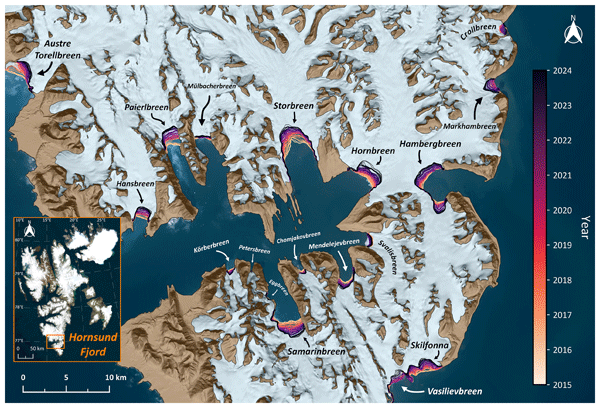
Monthly frontal ablation is quantified at 147 Svalbard tidewater glaciers from 2015–2024 using terminus positions derived from a deep-learning segmentation model's predictions of the calving fronts on satellite radar images. Our high spatio-temporal resolution results will improve the process understanding of frontal ablation, provide reference data for the modeling community, and deliver an ideal dataset for studying controls of frontal ablation.
Akash M. Patil, Christoph Mayer, Theo M. Jenk, Astrid Lambrecht, Thorsten Seehaus, Alexander R. Groos, and Michelle Worek
The Cryosphere, 20, 4927–4955, https://doi.org/10.5194/tc-20-4927-2026, https://doi.org/10.5194/tc-20-4927-2026, 2026
Short summary
Short summary
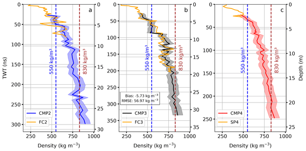
Our study focused on understanding how a warming climate affects the Aletsch Glacier accumulation area. We used multi-year radar measurements and direct firn‑core analyses to estimate changes in density and compaction rate of snow-to-ice over a year. Our results show that the upper layers of the glacier are changing faster due to stronger summer melt in the lower parts of the accumulation zone. Our findings help to improve firn densification models and glacier mass-balance estimation.
Theresa Dobler, Wilfried Hagg, Martin Rückamp, Thorsten Seehaus, and Christoph Mayer
The Cryosphere, 20, 2531–2555, https://doi.org/10.5194/tc-20-2531-2026, https://doi.org/10.5194/tc-20-2531-2026, 2026
Short summary
Short summary
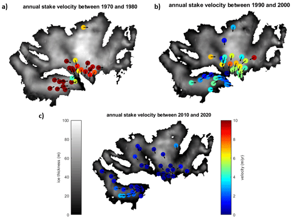
We studied how a glacier in the Austrian Alps moves more slowly over time due to climate change. By combining long-term field data with recent aerial images, we show how thinning reduce glacier flow. Our findings help understand changes in glacier behavior in a warming climate.
Vijaya Kumar Thota, Thorsten Seehaus, Friedrich Knuth, Amaury Dehecq, Christian Salewski, David Farías-Barahona, and Matthias H. Braun
Earth Syst. Sci. Data, 18, 597–615, https://doi.org/10.5194/essd-18-597-2026, https://doi.org/10.5194/essd-18-597-2026, 2026
Short summary
Short summary
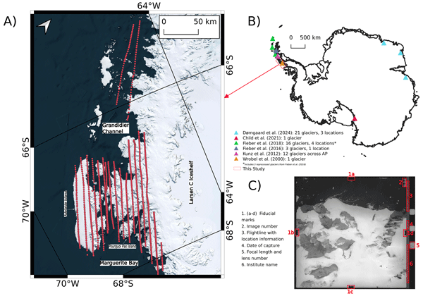
We reconstruct historical topography for a rapidly warming Antarctic region with limited existing data. Using approximately 2000 aerial photographs from the year 1989 over the western Antarctic Peninsula and nearby islands, we created detailed elevation models and orthoimages that have high accuracy compared to recent satellite data. This open dataset aids tracking historical ice loss and its role in sea level rise.
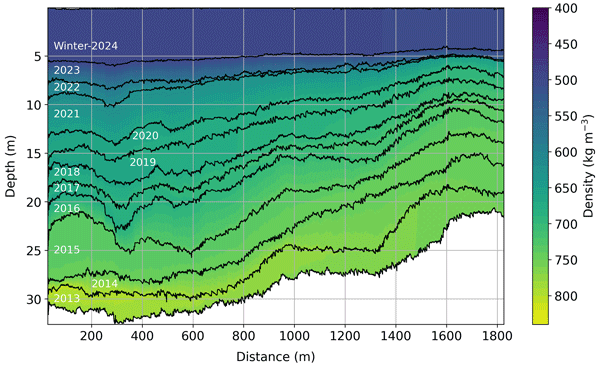
Akash M. Patil, Christoph Mayer, Thorsten Seehaus, Alexander R. Groos, and Andreas Bauder
The Cryosphere, 19, 5547–5577, https://doi.org/10.5194/tc-19-5547-2025, https://doi.org/10.5194/tc-19-5547-2025, 2025
Short summary
Short summary
We studied how the density of snow to ice transition varies with depth in the Aletsch glacier using radar-based field measurements and some simple models. We showed that it is possible to track how much snow has accumulated in the last 10–14 years. This helps improve the uncertainties in glacier mass balance estimates. Overall, by utilising non-invasive radar techniques and models, we provide a novel approach to understanding the evolution of glaciers under regional climate conditions.
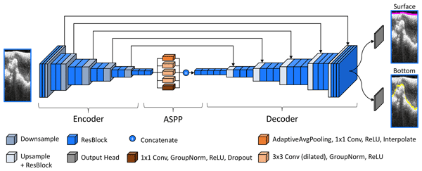
Marcel Dreier, Moritz Koch, Nora Gourmelon, Norbert Blindow, Daniel Steinhage, Fei Wu, Thorsten Seehaus, Matthias Braun, Andreas Maier, and Vincent Christlein
The Cryosphere, 19, 5337–5359, https://doi.org/10.5194/tc-19-5337-2025, https://doi.org/10.5194/tc-19-5337-2025, 2025
Short summary
Short summary
In this paper, we present a ready-to-use benchmark dataset to train machine learning approaches for detecting ice thickness from radar data. It includes radargrams of glaciers and ice sheets alongside annotations for their air–ice and ice–bedrock boundary. Furthermore, we introduce a baseline model and evaluate the influence of several geographical and glaciological factors on the performance of our model.
Kaian Shahateet, Johannes J. Fürst, Francisco Navarro, Thorsten Seehaus, Daniel Farinotti, and Matthias Braun
The Cryosphere, 19, 1577–1597, https://doi.org/10.5194/tc-19-1577-2025, https://doi.org/10.5194/tc-19-1577-2025, 2025
Short summary
Short summary
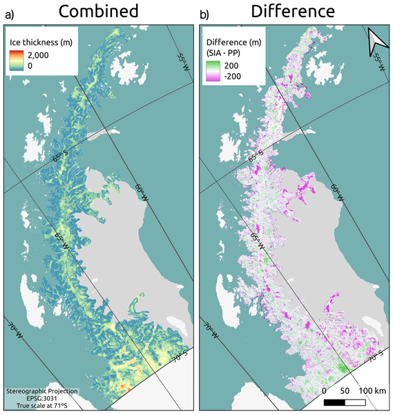
In the present work, we provide a new ice thickness reconstruction of the Antarctic Peninsula Ice Sheet north of 70º S using inversion modeling. This model consists of two steps: the first uses basic assumptions of the rheology of the glacier, and the second uses mass conservation to improve the reconstruction where the assumptions made previously are expected to fail. Validation with independent data showed that our reconstruction improved compared to other reconstructions that are available.
Katrina Lutz, Lily Bever, Christian Sommer, Thorsten Seehaus, Angelika Humbert, Mirko Scheinert, and Matthias Braun
The Cryosphere, 18, 5431–5449, https://doi.org/10.5194/tc-18-5431-2024, https://doi.org/10.5194/tc-18-5431-2024, 2024
Short summary
Short summary
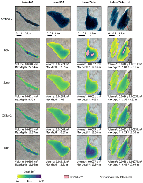
The estimation of the amount of water found within supraglacial lakes is important for understanding how much water is lost from glaciers each year. Here, we develop two new methods for estimating supraglacial lake volume that can be easily applied on a large scale. Furthermore, we compare these methods to two previously developed methods in order to determine when it is best to use each method. Finally, three of these methods are applied to peak melt dates over an area in Northeast Greenland.
Livia Piermattei, Michael Zemp, Christian Sommer, Fanny Brun, Matthias H. Braun, Liss M. Andreassen, Joaquín M. C. Belart, Etienne Berthier, Atanu Bhattacharya, Laura Boehm Vock, Tobias Bolch, Amaury Dehecq, Inés Dussaillant, Daniel Falaschi, Caitlyn Florentine, Dana Floricioiu, Christian Ginzler, Gregoire Guillet, Romain Hugonnet, Matthias Huss, Andreas Kääb, Owen King, Christoph Klug, Friedrich Knuth, Lukas Krieger, Jeff La Frenierre, Robert McNabb, Christopher McNeil, Rainer Prinz, Louis Sass, Thorsten Seehaus, David Shean, Désirée Treichler, Anja Wendt, and Ruitang Yang
The Cryosphere, 18, 3195–3230, https://doi.org/10.5194/tc-18-3195-2024, https://doi.org/10.5194/tc-18-3195-2024, 2024
Short summary
Short summary
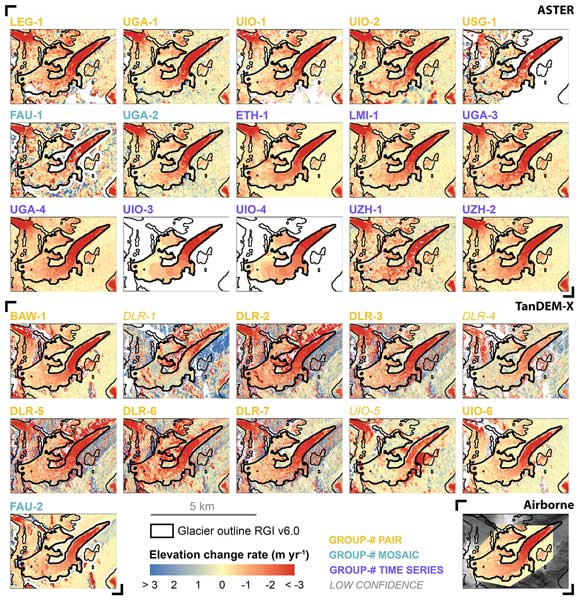
Satellites have made it possible to observe glacier elevation changes from all around the world. In the present study, we compared the results produced from two different types of satellite data between different research groups and against validation measurements from aeroplanes. We found a large spread between individual results but showed that the group ensemble can be used to reliably estimate glacier elevation changes and related errors from satellite data.
Oskar Herrmann, Nora Gourmelon, Thorsten Seehaus, Andreas Maier, Johannes J. Fürst, Matthias H. Braun, and Vincent Christlein
The Cryosphere, 17, 4957–4977, https://doi.org/10.5194/tc-17-4957-2023, https://doi.org/10.5194/tc-17-4957-2023, 2023
Short summary
Short summary
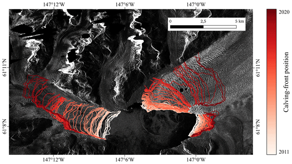
Delineating calving fronts of marine-terminating glaciers in satellite images is a labour-intensive task. We propose a method based on deep learning that automates this task. We choose a deep learning framework that adapts to any given dataset without needing deep learning expertise. The method is evaluated on a benchmark dataset for calving-front detection and glacier zone segmentation. The framework can beat the benchmark baseline without major modifications.
Thorsten Seehaus, Christian Sommer, Thomas Dethinne, and Philipp Malz
The Cryosphere, 17, 4629–4644, https://doi.org/10.5194/tc-17-4629-2023, https://doi.org/10.5194/tc-17-4629-2023, 2023
Short summary
Short summary
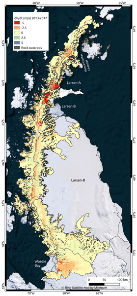
Existing mass budget estimates for the northern Antarctic Peninsula (>70° S) are affected by considerable limitations. We carried out the first region-wide analysis of geodetic mass balances throughout this region (coverage of 96.4 %) for the period 2013–2017 based on repeat pass bi-static TanDEM-X acquisitions. A total mass budget of −24.1±2.8 Gt/a is revealed. Imbalanced high ice discharge, particularly at former ice shelf tributaries, is the main driver of overall ice loss.
Alexandra M. Zuhr, Erik Loebel, Marek Muchow, Donovan Dennis, Luisa von Albedyll, Frigga Kruse, Heidemarie Kassens, Johanna Grabow, Dieter Piepenburg, Sören Brandt, Rainer Lehmann, Marlene Jessen, Friederike Krüger, Monika Kallfelz, Andreas Preußer, Matthias Braun, Thorsten Seehaus, Frank Lisker, Daniela Röhnert, and Mirko Scheinert
Polarforschung, 91, 73–80, https://doi.org/10.5194/polf-91-73-2023, https://doi.org/10.5194/polf-91-73-2023, 2023
Short summary
Short summary
Polar research is an interdisciplinary and multi-faceted field of research. Its diversity ranges from history to geology and geophysics to social sciences and education. This article provides insights into the different areas of German polar research. This was made possible by a seminar series, POLARSTUNDE, established in the summer of 2020 and organized by the German Society of Polar Research and the German National Committee of the Association of Polar Early Career Scientists (APECS Germany).
Franziska Temme, David Farías-Barahona, Thorsten Seehaus, Ricardo Jaña, Jorge Arigony-Neto, Inti Gonzalez, Anselm Arndt, Tobias Sauter, Christoph Schneider, and Johannes J. Fürst
The Cryosphere, 17, 2343–2365, https://doi.org/10.5194/tc-17-2343-2023, https://doi.org/10.5194/tc-17-2343-2023, 2023
Short summary
Short summary
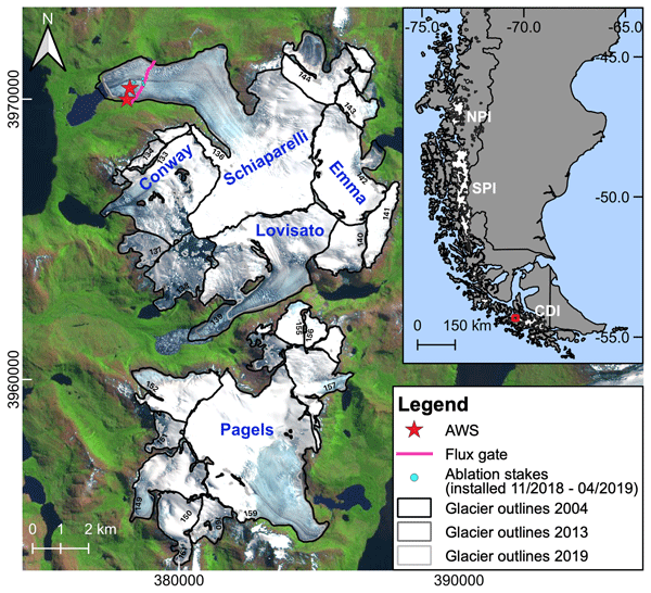
Calibration of surface mass balance (SMB) models on regional scales is challenging. We investigate different calibration strategies with the goal of achieving realistic simulations of the SMB in the Monte Sarmiento Massif, Tierra del Fuego. Our results show that the use of regional observations from satellite data can improve the model performance. Furthermore, we compare four melt models of different complexity to understand the benefit of increasing the processes considered in the model.
Nora Gourmelon, Thorsten Seehaus, Matthias Braun, Andreas Maier, and Vincent Christlein
Earth Syst. Sci. Data, 14, 4287–4313, https://doi.org/10.5194/essd-14-4287-2022, https://doi.org/10.5194/essd-14-4287-2022, 2022
Short summary
Short summary
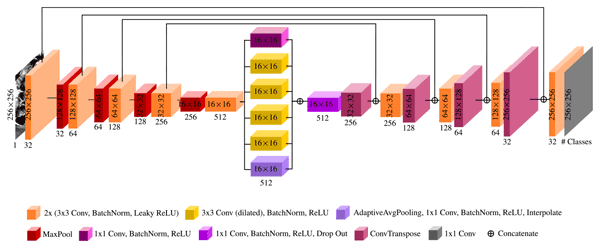
Ice loss of glaciers shows in retreating calving fronts (i.e., the position where icebergs break off the glacier and drift into the ocean). This paper presents a benchmark dataset for calving front delineation in synthetic aperture radar (SAR) images. The dataset can be used to train and test deep learning techniques, which automate the monitoring of the calving front. Provided example models achieve front delineations with an average distance of 887 m to the correct calving front.
Christian Sommer, Thorsten Seehaus, Andrey Glazovsky, and Matthias H. Braun
The Cryosphere, 16, 35–42, https://doi.org/10.5194/tc-16-35-2022, https://doi.org/10.5194/tc-16-35-2022, 2022
Short summary
Short summary
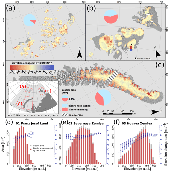
Arctic glaciers have been subject to extensive warming due to global climate change, yet their contribution to sea level rise has been relatively small in the past. In this study we provide mass changes of most glaciers of the Russian High Arctic (Franz Josef Land, Severnaya Zemlya, Novaya Zemlya). We use TanDEM-X satellite measurements to derive glacier surface elevation changes. Our results show an increase in glacier mass loss and a sea level rise contribution of 0.06 mm/a (2010–2017).
Dakota Pyles, Marcel Dreier, Anna Wendleder, Will Kochtitzky, Nora Gourmelon, Vincent Christlein, and Thorsten Seehaus
Earth Syst. Sci. Data, 18, 7319–7344, https://doi.org/10.5194/essd-18-7319-2026, https://doi.org/10.5194/essd-18-7319-2026, 2026
Short summary
Short summary
Monthly frontal ablation is quantified at 147 Svalbard tidewater glaciers from 2015–2024 using terminus positions derived from a deep-learning segmentation model's predictions of the calving fronts on satellite radar images. Our high spatio-temporal resolution results will improve the process understanding of frontal ablation, provide reference data for the modeling community, and deliver an ideal dataset for studying controls of frontal ablation.
Akash M. Patil, Christoph Mayer, Theo M. Jenk, Astrid Lambrecht, Thorsten Seehaus, Alexander R. Groos, and Michelle Worek
The Cryosphere, 20, 4927–4955, https://doi.org/10.5194/tc-20-4927-2026, https://doi.org/10.5194/tc-20-4927-2026, 2026
Short summary
Short summary
Our study focused on understanding how a warming climate affects the Aletsch Glacier accumulation area. We used multi-year radar measurements and direct firn‑core analyses to estimate changes in density and compaction rate of snow-to-ice over a year. Our results show that the upper layers of the glacier are changing faster due to stronger summer melt in the lower parts of the accumulation zone. Our findings help to improve firn densification models and glacier mass-balance estimation.
David N. Wiese, Johan Nilsson, Nicole-Jeanne Schlegel, Alex S. Gardner, Matthias Ellmer, and Felix W. Landerer
EGUsphere, https://doi.org/10.5194/egusphere-2026-4404, https://doi.org/10.5194/egusphere-2026-4404, 2026
This preprint is open for discussion and under review for The Cryosphere (TC).
Short summary
Short summary
Tracking Antarctic ice loss is vital for predicting sea-level rise. Satellite gravity measurements reliably track overall mass changes, while height measurements capture fine local details. We combined two decades of both satellite records into a unified model. This boosts mapping clarity tenfold, revealing ice loss from broad regional scales down to individual glaciers. These refined maps help scientists monitor vulnerable ice streams and improve climate projections.
Jing Zhang, Yang Lei, Laurane Charrier, Amaury Dehecq, Alex S. Gardner, Luke Copland, and Christine Dow
EGUsphere, https://doi.org/10.5194/egusphere-2026-2541, https://doi.org/10.5194/egusphere-2026-2541, 2026
This preprint is open for discussion and under review for The Cryosphere (TC).
Short summary
Short summary
Satellites can measure how fast glaciers move, which helps scientists understand ice loss and rising sea levels. However, these measurements have rarely been checked against ground-based observations on small mountain glaciers. We compared satellite-derived glacier speeds against precise ground measurements. The satellite data generally agreed well with ground observations. Our results help scientists use satellite glacier velocity data more reliably.
Theresa Dobler, Wilfried Hagg, Martin Rückamp, Thorsten Seehaus, and Christoph Mayer
The Cryosphere, 20, 2531–2555, https://doi.org/10.5194/tc-20-2531-2026, https://doi.org/10.5194/tc-20-2531-2026, 2026
Short summary
Short summary
We studied how a glacier in the Austrian Alps moves more slowly over time due to climate change. By combining long-term field data with recent aerial images, we show how thinning reduce glacier flow. Our findings help understand changes in glacier behavior in a warming climate.
Johan Nilsson and Alex S. Gardner
Earth Syst. Sci. Data, 18, 1729–1745, https://doi.org/10.5194/essd-18-1729-2026, https://doi.org/10.5194/essd-18-1729-2026, 2026
Short summary
Short summary
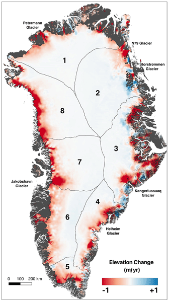
Integrating data from multiple satellite altimetry missions, we analyzed Greenland’s peripheral glaciers and Ice Sheet (GrIS) from 1992–2023. Our methodology ensures consistent, reliable elevation change data, now publicly available via NASA's ITS_LIVE project. The GrIS lost an average of -160 ± 17 Gt a-1 and peripheral glaciers -23 ± 5 Gt a-1 from 1992–2023. The study highlights the importance of continued monitoring to understand climate change impacts on Earth's Cryosphere.
Vijaya Kumar Thota, Thorsten Seehaus, Friedrich Knuth, Amaury Dehecq, Christian Salewski, David Farías-Barahona, and Matthias H. Braun
Earth Syst. Sci. Data, 18, 597–615, https://doi.org/10.5194/essd-18-597-2026, https://doi.org/10.5194/essd-18-597-2026, 2026
Short summary
Short summary
We reconstruct historical topography for a rapidly warming Antarctic region with limited existing data. Using approximately 2000 aerial photographs from the year 1989 over the western Antarctic Peninsula and nearby islands, we created detailed elevation models and orthoimages that have high accuracy compared to recent satellite data. This open dataset aids tracking historical ice loss and its role in sea level rise.
Maria T. Kappelsberger, Johan Nilsson, Martin Horwath, Veit Helm, and Alex S. Gardner
EGUsphere, https://doi.org/10.5194/egusphere-2025-5745, https://doi.org/10.5194/egusphere-2025-5745, 2025
Short summary
Short summary
We compare surface elevation changes of the Antarctic Ice Sheet interior as derived from satellite radar altimetry and laser altimetry between 2019 and 2024. Both methods indicate an increase in surface elevation across most of the study area, coinciding with an episode of excess snow accumulation as modelled. However, rates of surface elevation increase from radar altimetry are systematically lower than those from laser altimetry.
Akash M. Patil, Christoph Mayer, Thorsten Seehaus, Alexander R. Groos, and Andreas Bauder
The Cryosphere, 19, 5547–5577, https://doi.org/10.5194/tc-19-5547-2025, https://doi.org/10.5194/tc-19-5547-2025, 2025
Short summary
Short summary
We studied how the density of snow to ice transition varies with depth in the Aletsch glacier using radar-based field measurements and some simple models. We showed that it is possible to track how much snow has accumulated in the last 10–14 years. This helps improve the uncertainties in glacier mass balance estimates. Overall, by utilising non-invasive radar techniques and models, we provide a novel approach to understanding the evolution of glaciers under regional climate conditions.
Marcel Dreier, Moritz Koch, Nora Gourmelon, Norbert Blindow, Daniel Steinhage, Fei Wu, Thorsten Seehaus, Matthias Braun, Andreas Maier, and Vincent Christlein
The Cryosphere, 19, 5337–5359, https://doi.org/10.5194/tc-19-5337-2025, https://doi.org/10.5194/tc-19-5337-2025, 2025
Short summary
Short summary
In this paper, we present a ready-to-use benchmark dataset to train machine learning approaches for detecting ice thickness from radar data. It includes radargrams of glaciers and ice sheets alongside annotations for their air–ice and ice–bedrock boundary. Furthermore, we introduce a baseline model and evaluate the influence of several geographical and glaciological factors on the performance of our model.
Alex S. Gardner, Chad A. Greene, Joseph H. Kennedy, Mark A. Fahnestock, Maria Liukis, Luis A. López, Yang Lei, Ted A. Scambos, and Amaury Dehecq
The Cryosphere, 19, 3517–3533, https://doi.org/10.5194/tc-19-3517-2025, https://doi.org/10.5194/tc-19-3517-2025, 2025
Short summary
Short summary
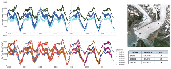
The NASA MEaSUREs Inter-mission Time Series of Land Ice Velocity and Elevation (ITS_LIVE) project provides glacier and ice sheet velocity products for the full Landsat, Sentinel-1, and Sentinel-2 satellite archives and will soon include data from the NISAR satellite. This paper describes the ITS_LIVE processing chain and gives guidance for working with the cloud-optimized glacier and ice sheet velocity products.
Ankita Vashishtha, Pietro Milillo, Alexandre Becker Campos, Jose Luis Bueso Bello, Paola Rizzoli, and Johan Nilsson
EGUsphere, https://doi.org/10.5194/egusphere-2025-1979, https://doi.org/10.5194/egusphere-2025-1979, 2025
Short summary
Short summary
We developed a new method to improve satellite elevation models of Antarctica by using artificial intelligence. Our method combines radar and laser satellite data with weather information to correct for measurement errors caused by radar signals penetrating snow and ice. This makes elevation maps up to ten times more accurate compared to current , helping scientists better track changes in ice and snow. Our results directly inform future space missions to monitor Earth’s changing surface.
Kaian Shahateet, Johannes J. Fürst, Francisco Navarro, Thorsten Seehaus, Daniel Farinotti, and Matthias Braun
The Cryosphere, 19, 1577–1597, https://doi.org/10.5194/tc-19-1577-2025, https://doi.org/10.5194/tc-19-1577-2025, 2025
Short summary
Short summary
In the present work, we provide a new ice thickness reconstruction of the Antarctic Peninsula Ice Sheet north of 70º S using inversion modeling. This model consists of two steps: the first uses basic assumptions of the rheology of the glacier, and the second uses mass conservation to improve the reconstruction where the assumptions made previously are expected to fail. Validation with independent data showed that our reconstruction improved compared to other reconstructions that are available.
Katrina Lutz, Lily Bever, Christian Sommer, Thorsten Seehaus, Angelika Humbert, Mirko Scheinert, and Matthias Braun
The Cryosphere, 18, 5431–5449, https://doi.org/10.5194/tc-18-5431-2024, https://doi.org/10.5194/tc-18-5431-2024, 2024
Short summary
Short summary
The estimation of the amount of water found within supraglacial lakes is important for understanding how much water is lost from glaciers each year. Here, we develop two new methods for estimating supraglacial lake volume that can be easily applied on a large scale. Furthermore, we compare these methods to two previously developed methods in order to determine when it is best to use each method. Finally, three of these methods are applied to peak melt dates over an area in Northeast Greenland.
Livia Piermattei, Michael Zemp, Christian Sommer, Fanny Brun, Matthias H. Braun, Liss M. Andreassen, Joaquín M. C. Belart, Etienne Berthier, Atanu Bhattacharya, Laura Boehm Vock, Tobias Bolch, Amaury Dehecq, Inés Dussaillant, Daniel Falaschi, Caitlyn Florentine, Dana Floricioiu, Christian Ginzler, Gregoire Guillet, Romain Hugonnet, Matthias Huss, Andreas Kääb, Owen King, Christoph Klug, Friedrich Knuth, Lukas Krieger, Jeff La Frenierre, Robert McNabb, Christopher McNeil, Rainer Prinz, Louis Sass, Thorsten Seehaus, David Shean, Désirée Treichler, Anja Wendt, and Ruitang Yang
The Cryosphere, 18, 3195–3230, https://doi.org/10.5194/tc-18-3195-2024, https://doi.org/10.5194/tc-18-3195-2024, 2024
Short summary
Short summary
Satellites have made it possible to observe glacier elevation changes from all around the world. In the present study, we compared the results produced from two different types of satellite data between different research groups and against validation measurements from aeroplanes. We found a large spread between individual results but showed that the group ensemble can be used to reliably estimate glacier elevation changes and related errors from satellite data.
Brian Menounos, Alex Gardner, Caitlyn Florentine, and Andrew Fountain
The Cryosphere, 18, 889–894, https://doi.org/10.5194/tc-18-889-2024, https://doi.org/10.5194/tc-18-889-2024, 2024
Short summary
Short summary
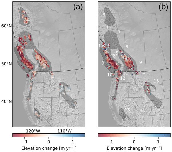
Glaciers in western North American outside of Alaska are often overlooked in global studies because their potential to contribute to changes in sea level is small. Nonetheless, these glaciers represent important sources of freshwater, especially during times of drought. We show that these glaciers lost mass at a rate of about 12 Gt yr-1 for about the period 2013–2021; the rate of mass loss over the period 2018–2022 was similar.
Youngmin Choi, Helene Seroussi, Mathieu Morlighem, Nicole-Jeanne Schlegel, and Alex Gardner
The Cryosphere, 17, 5499–5517, https://doi.org/10.5194/tc-17-5499-2023, https://doi.org/10.5194/tc-17-5499-2023, 2023
Short summary
Short summary
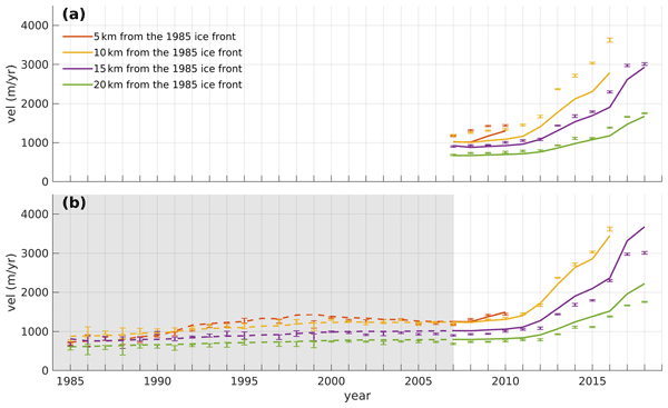
Ice sheet models are often initialized using snapshot observations of present-day conditions, but this approach has limitations in capturing the transient evolution of the system. To more accurately represent the accelerating changes in glaciers, we employed time-dependent data assimilation. We found that models calibrated with the transient data better capture past trends and more accurately reproduce changes after the calibration period, even with limited observations.
Oskar Herrmann, Nora Gourmelon, Thorsten Seehaus, Andreas Maier, Johannes J. Fürst, Matthias H. Braun, and Vincent Christlein
The Cryosphere, 17, 4957–4977, https://doi.org/10.5194/tc-17-4957-2023, https://doi.org/10.5194/tc-17-4957-2023, 2023
Short summary
Short summary
Delineating calving fronts of marine-terminating glaciers in satellite images is a labour-intensive task. We propose a method based on deep learning that automates this task. We choose a deep learning framework that adapts to any given dataset without needing deep learning expertise. The method is evaluated on a benchmark dataset for calving-front detection and glacier zone segmentation. The framework can beat the benchmark baseline without major modifications.
Thorsten Seehaus, Christian Sommer, Thomas Dethinne, and Philipp Malz
The Cryosphere, 17, 4629–4644, https://doi.org/10.5194/tc-17-4629-2023, https://doi.org/10.5194/tc-17-4629-2023, 2023
Short summary
Short summary
Existing mass budget estimates for the northern Antarctic Peninsula (>70° S) are affected by considerable limitations. We carried out the first region-wide analysis of geodetic mass balances throughout this region (coverage of 96.4 %) for the period 2013–2017 based on repeat pass bi-static TanDEM-X acquisitions. A total mass budget of −24.1±2.8 Gt/a is revealed. Imbalanced high ice discharge, particularly at former ice shelf tributaries, is the main driver of overall ice loss.
Alexandra M. Zuhr, Erik Loebel, Marek Muchow, Donovan Dennis, Luisa von Albedyll, Frigga Kruse, Heidemarie Kassens, Johanna Grabow, Dieter Piepenburg, Sören Brandt, Rainer Lehmann, Marlene Jessen, Friederike Krüger, Monika Kallfelz, Andreas Preußer, Matthias Braun, Thorsten Seehaus, Frank Lisker, Daniela Röhnert, and Mirko Scheinert
Polarforschung, 91, 73–80, https://doi.org/10.5194/polf-91-73-2023, https://doi.org/10.5194/polf-91-73-2023, 2023
Short summary
Short summary
Polar research is an interdisciplinary and multi-faceted field of research. Its diversity ranges from history to geology and geophysics to social sciences and education. This article provides insights into the different areas of German polar research. This was made possible by a seminar series, POLARSTUNDE, established in the summer of 2020 and organized by the German Society of Polar Research and the German National Committee of the Association of Polar Early Career Scientists (APECS Germany).
Fernando S. Paolo, Alex S. Gardner, Chad A. Greene, Johan Nilsson, Michael P. Schodlok, Nicole-Jeanne Schlegel, and Helen A. Fricker
The Cryosphere, 17, 3409–3433, https://doi.org/10.5194/tc-17-3409-2023, https://doi.org/10.5194/tc-17-3409-2023, 2023
Short summary
Short summary
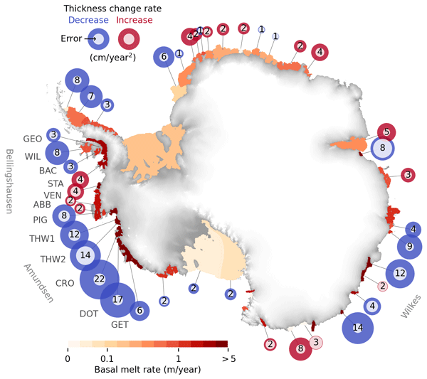
We report on a slowdown in the rate of thinning and melting of West Antarctic ice shelves. We present a comprehensive assessment of the Antarctic ice shelves, where we analyze at a continental scale the changes in thickness, flow, and basal melt over the past 26 years. We also present a novel method to estimate ice shelf change from satellite altimetry and a time-dependent data set of ice shelf thickness and basal melt rates at an unprecedented resolution.
Franziska Temme, David Farías-Barahona, Thorsten Seehaus, Ricardo Jaña, Jorge Arigony-Neto, Inti Gonzalez, Anselm Arndt, Tobias Sauter, Christoph Schneider, and Johannes J. Fürst
The Cryosphere, 17, 2343–2365, https://doi.org/10.5194/tc-17-2343-2023, https://doi.org/10.5194/tc-17-2343-2023, 2023
Short summary
Short summary
Calibration of surface mass balance (SMB) models on regional scales is challenging. We investigate different calibration strategies with the goal of achieving realistic simulations of the SMB in the Monte Sarmiento Massif, Tierra del Fuego. Our results show that the use of regional observations from satellite data can improve the model performance. Furthermore, we compare four melt models of different complexity to understand the benefit of increasing the processes considered in the model.
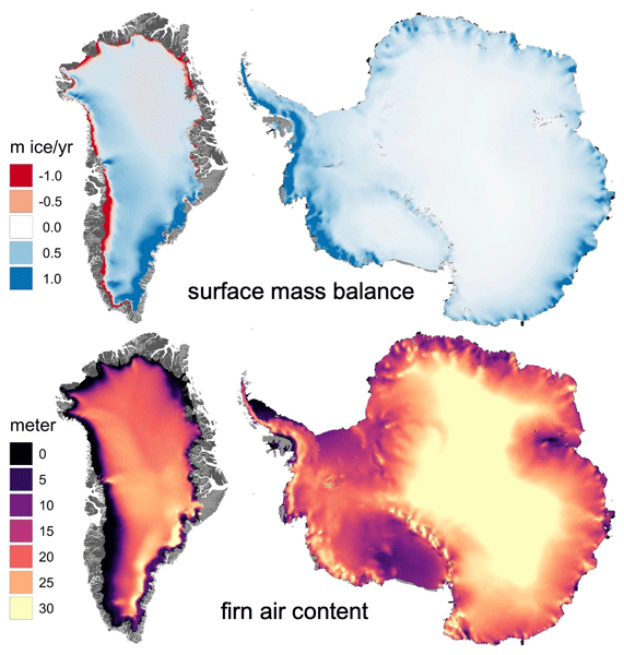
Alex S. Gardner, Nicole-Jeanne Schlegel, and Eric Larour
Geosci. Model Dev., 16, 2277–2302, https://doi.org/10.5194/gmd-16-2277-2023, https://doi.org/10.5194/gmd-16-2277-2023, 2023
Short summary
Short summary
This is the first description of the open-source Glacier Energy and Mass Balance (GEMB) model. GEMB models the ice sheet and glacier surface–atmospheric energy and mass exchange, as well as the firn state. The model is evaluated against the current state of the art and in situ observations and is shown to perform well.
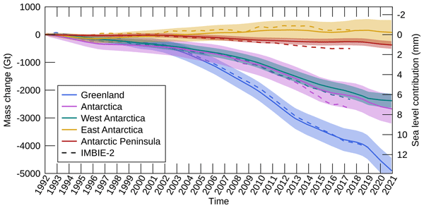
Inès N. Otosaka, Andrew Shepherd, Erik R. Ivins, Nicole-Jeanne Schlegel, Charles Amory, Michiel R. van den Broeke, Martin Horwath, Ian Joughin, Michalea D. King, Gerhard Krinner, Sophie Nowicki, Anthony J. Payne, Eric Rignot, Ted Scambos, Karen M. Simon, Benjamin E. Smith, Louise S. Sørensen, Isabella Velicogna, Pippa L. Whitehouse, Geruo A, Cécile Agosta, Andreas P. Ahlstrøm, Alejandro Blazquez, William Colgan, Marcus E. Engdahl, Xavier Fettweis, Rene Forsberg, Hubert Gallée, Alex Gardner, Lin Gilbert, Noel Gourmelen, Andreas Groh, Brian C. Gunter, Christopher Harig, Veit Helm, Shfaqat Abbas Khan, Christoph Kittel, Hannes Konrad, Peter L. Langen, Benoit S. Lecavalier, Chia-Chun Liang, Bryant D. Loomis, Malcolm McMillan, Daniele Melini, Sebastian H. Mernild, Ruth Mottram, Jeremie Mouginot, Johan Nilsson, Brice Noël, Mark E. Pattle, William R. Peltier, Nadege Pie, Mònica Roca, Ingo Sasgen, Himanshu V. Save, Ki-Weon Seo, Bernd Scheuchl, Ernst J. O. Schrama, Ludwig Schröder, Sebastian B. Simonsen, Thomas Slater, Giorgio Spada, Tyler C. Sutterley, Bramha Dutt Vishwakarma, Jan Melchior van Wessem, David Wiese, Wouter van der Wal, and Bert Wouters
Earth Syst. Sci. Data, 15, 1597–1616, https://doi.org/10.5194/essd-15-1597-2023, https://doi.org/10.5194/essd-15-1597-2023, 2023
Short summary
Short summary
By measuring changes in the volume, gravitational attraction, and ice flow of Greenland and Antarctica from space, we can monitor their mass gain and loss over time. Here, we present a new record of the Earth’s polar ice sheet mass balance produced by aggregating 50 satellite-based estimates of ice sheet mass change. This new assessment shows that the ice sheets have lost (7.5 x 10¹²) t of ice between 1992 and 2020, contributing 21 mm to sea level rise.

Yang Lei, Alex S. Gardner, and Piyush Agram
Earth Syst. Sci. Data, 14, 5111–5137, https://doi.org/10.5194/essd-14-5111-2022, https://doi.org/10.5194/essd-14-5111-2022, 2022
Short summary
Short summary
This work describes NASA MEaSUREs ITS_LIVE project's Version 2 Sentinel-1 image-pair ice velocity product and processing methodology. We show the refined offset tracking algorithm, autoRIFT, calibration for Sentinel-1 geolocation biases and correction of the ionosphere streaking problems. Validation was performed over three typical test sites covering the globe by comparing with other similar global and regional products.
Nora Gourmelon, Thorsten Seehaus, Matthias Braun, Andreas Maier, and Vincent Christlein
Earth Syst. Sci. Data, 14, 4287–4313, https://doi.org/10.5194/essd-14-4287-2022, https://doi.org/10.5194/essd-14-4287-2022, 2022
Short summary
Short summary
Ice loss of glaciers shows in retreating calving fronts (i.e., the position where icebergs break off the glacier and drift into the ocean). This paper presents a benchmark dataset for calving front delineation in synthetic aperture radar (SAR) images. The dataset can be used to train and test deep learning techniques, which automate the monitoring of the calving front. Provided example models achieve front delineations with an average distance of 887 m to the correct calving front.
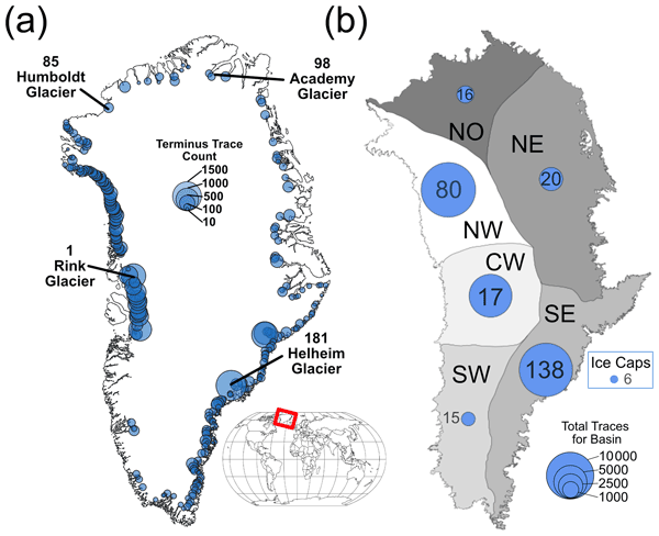
Sophie Goliber, Taryn Black, Ginny Catania, James M. Lea, Helene Olsen, Daniel Cheng, Suzanne Bevan, Anders Bjørk, Charlie Bunce, Stephen Brough, J. Rachel Carr, Tom Cowton, Alex Gardner, Dominik Fahrner, Emily Hill, Ian Joughin, Niels J. Korsgaard, Adrian Luckman, Twila Moon, Tavi Murray, Andrew Sole, Michael Wood, and Enze Zhang
The Cryosphere, 16, 3215–3233, https://doi.org/10.5194/tc-16-3215-2022, https://doi.org/10.5194/tc-16-3215-2022, 2022
Short summary
Short summary
Terminus traces have been used to understand how Greenland's glaciers have changed over time; however, manual digitization is time-intensive, and a lack of coordination leads to duplication of efforts. We have compiled a dataset of over 39 000 terminus traces for 278 glaciers for scientific and machine learning applications. We also provide an overview of an updated version of the Google Earth Engine Digitization Tool (GEEDiT), which has been developed specifically for the Greenland Ice Sheet.
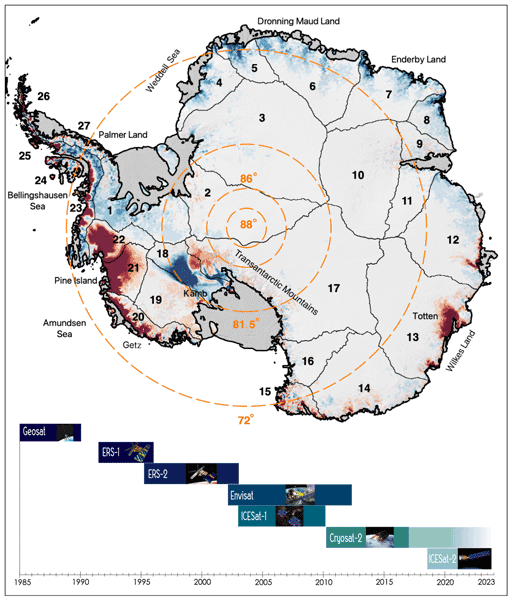
Johan Nilsson, Alex S. Gardner, and Fernando S. Paolo
Earth Syst. Sci. Data, 14, 3573–3598, https://doi.org/10.5194/essd-14-3573-2022, https://doi.org/10.5194/essd-14-3573-2022, 2022
Short summary
Short summary
The longest observational record available to study the mass balance of the Earth’s ice sheets comes from satellite altimeters. This record consists of multiple satellite missions with different measurements and quality, and it must be cross-calibrated and integrated into a consistent record for scientific use. Here, we present a novel approach for generating such a record providing a seamless record of elevation change for the Antarctic Ice Sheet that spans the period 1985 to 2020.
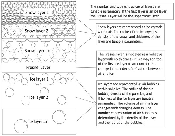
Chloe A. Whicker, Mark G. Flanner, Cheng Dang, Charles S. Zender, Joseph M. Cook, and Alex S. Gardner
The Cryosphere, 16, 1197–1220, https://doi.org/10.5194/tc-16-1197-2022, https://doi.org/10.5194/tc-16-1197-2022, 2022
Short summary
Short summary
Snow and ice surfaces are important to the global climate. Current climate models use measurements to determine the reflectivity of ice. This model uses physical properties to determine the reflectivity of snow, ice, and darkly pigmented impurities that reside within the snow and ice. Therefore, the modeled reflectivity is more accurate for snow/ice columns under varying climate conditions. This model paves the way for improvements in the portrayal of snow and ice within global climate models.
Christian Sommer, Thorsten Seehaus, Andrey Glazovsky, and Matthias H. Braun
The Cryosphere, 16, 35–42, https://doi.org/10.5194/tc-16-35-2022, https://doi.org/10.5194/tc-16-35-2022, 2022
Short summary
Short summary
Arctic glaciers have been subject to extensive warming due to global climate change, yet their contribution to sea level rise has been relatively small in the past. In this study we provide mass changes of most glaciers of the Russian High Arctic (Franz Josef Land, Severnaya Zemlya, Novaya Zemlya). We use TanDEM-X satellite measurements to derive glacier surface elevation changes. Our results show an increase in glacier mass loss and a sea level rise contribution of 0.06 mm/a (2010–2017).
Cited articles
Berthier, E., Scambos, T. A., and Shuman, C. A.: Mass loss of Larsen-B tributary glaciers (Antarctic Peninsula) unabated since 2002, Geophys. Res. Lett., 39, https://doi.org/10.1029/2012GL051755, 2012.
Breiman, L.: Random Forests, Mach. Learn., 45, 5–32, https://doi.org/10.1023/A:1010933404324, 2001.
Dahlke, S., Hughes, N. E., Wagner, P. M., Gerland, S., Wawrzyniak, T., Ivanov, B., and Maturilli, M.: The observed recent surface air temperature development across Svalbard and concurring footprints in local sea ice cover, Int. J. Climatol., 40, 5246–5265, https://doi.org/10.1002/joc.6517, 2020.
Dong, Y., Zhao, J., Floricioiu, D., Krieger, L., Fritz, T., and Eineder, M.: High-resolution topography of the Antarctic Peninsula combining the TanDEM-X DEM and Reference Elevation Model of Antarctica (REMA) mosaic, The Cryosphere, 15, 4421–4443, https://doi.org/10.5194/tc-15-4421-2021, 2021.
Fan, Y., Ke, C.-Q., Zhou, X., Shen, X., Yu, X., and Lhakpa, D.: Glacier mass-balance estimates over High Mountain Asia from 2000 to 2021 based on ICESat-2 and NASADEM, J. Glaciol., 69, 1–13, https://doi.org/10.1017/jog.2022.78, 2022.
Friedl, P., Seehaus, T., and Braun, M.: Global time series and temporal mosaics of glacier surface velocities derived from Sentinel-1 data, Earth Syst. Sci. Data, 13, 4653–4675, https://doi.org/10.5194/essd-13-4653-2021, 2021.
Gardner, A. S., Moholdt, G., Cogley, J. G., Wouters, B., Arendt, A. A., Wahr, J., Berthier, E., Hock, R., Pfeffer, W. T., Kaser, G., Ligtenberg, S. R. M., Bolch, T., Sharp, M. J., Hagen, J. O., van den Broeke, M. R., and Paul, F.: A Reconciled Estimate of Glacier Contributions to Sea Level Rise: 2003 to 2009, Science, 340, 852–857, https://doi.org/10.1126/science.1234532, 2013.
Gardner, A. S., Greene, C. A., Kennedy, J. H., Fahnestock, M. A., Liukis, M., López, L. A., Lei, Y., Scambos, T. A., and Dehecq, A.: ITS_LIVE global glacier velocity data in near-real time, The Cryosphere, 19, 3517–3533, https://doi.org/10.5194/tc-19-3517-2025, 2025.
Guillet, G., Benn, D., King, O., Shean, D., Mannerfelt, E. S., and Hugonnet, R.: Global detection of glacier surges from surface velocities, elevation change, and SAR backscatter data between 2000 and 2024: a test of surge mechanism theories, J. Glaciol., 71, 1–41, https://doi.org/10.1017/jog.2025.10065, 2025.
Holzenkamp, M., Lyu, D., Kleinekathöfer, U., and Zaspel, P.: Evaluation of uncertainty estimations for Gaussian process regression-based machine learning interatomic potentials, arXiv [preprint], https://doi.org/10.48550/arXiv.2410.20398, 2025.
Howat, I. M., Smith, B. E., Joughin, I., and Scambos, T. A.: Rates of southeast Greenland ice volume loss from combined ICESat and ASTER observations, Geophys. Res. Lett., 35, https://doi.org/10.1029/2008GL034496, 2008.
Hugonnet, R., McNabb, R., Berthier, E., Menounos, B., Nuth, C., Girod, L., Farinotti, D., Huss, M., Dussaillant, I., Brun, F., and Kääb, A.: Accelerated global glacier mass loss in the early twenty-first century, Nature, 592, 726–731, https://doi.org/10.1038/s41586-021-03436-z, 2021.
Hurkmans, R. T. W. L., Bamber, J. L., Davis, C. H., Joughin, I. R., Khvorostovsky, K. S., Smith, B. S., and Schoen, N.: Time-evolving mass loss of the Greenland Ice Sheet from satellite altimetry, The Cryosphere, 8, 1725–1740, https://doi.org/10.5194/tc-8-1725-2014, 2014.
Lovell, H. and Muhammad, S.: Multiple phases of ice-dammed lake formation and drainage associated with a surge of Shisper Glacier, western Karakoram, J. Glaciol., 71, https://doi.org/10.1017/jog.2024.80, 2025.
Mannerfelt, E. S., Schellenberger, T., and Kääb, A. M.: Tracking glacier surge evolution using interferometric SAR coherence – examples from Svalbard, J. Glaciol., 1–17, https://doi.org/10.1017/jog.2025.27, 2025.
Markus, T., Neumann, T., Martino, A., Abdalati, W., Brunt, K., Csatho, B., Farrell, S., Fricker, H., Gardner, A., Harding, D., Jasinski, M., Kwok, R., Magruder, L., Lubin, D., Luthcke, S., Morison, J., Nelson, R., Neuenschwander, A., Palm, S., Popescu, S., Shum, C., Schutz, B. E., Smith, B., Yang, Y., and Zwally, J.: The Ice, Cloud, and land Elevation Satellite-2 (ICESat-2): Science requirements, concept, and implementation, Remote Sens. Environ., 190, 260–273, https://doi.org/10.1016/j.rse.2016.12.029, 2017.
McMillan, M., Shepherd, A., Sundal, A., Briggs, K., Muir, A., Ridout, A., Hogg, A., and Wingham, D.: Increased ice losses from Antarctica detected by CryoSat-2, Geophys. Res. Lett., 41, https://doi.org/10.1002/2014GL060111, 2014.
Moholdt, G., Nuth, C., Hagen, J. O., and Kohler, J.: Recent elevation changes of Svalbard glaciers derived from ICESat laser altimetry, Remote Sens. Environ., 114, 2756–2767, https://doi.org/10.1016/j.rse.2010.06.008, 2010.
Morris, A., Moholdt, G., and Gray, L.: Spread of Svalbard Glacier Mass Loss to Barents Sea Margins Revealed by CryoSat-2, J. Geophys. Res.-Earth, 125, https://doi.org/10.1029/2019JF005357, 2020.
Murray, T., Dowdeswell, J. A., Drewry, D. J., and Frearson, I.: Geometric evolution and ice dynamics during a surge of Bakaninbreen, Svalbard, J. Glaciol., 44, 263–272, https://doi.org/10.3189/S0022143000002604, 1998.
Neumann, T. A., Martino, A. J., Markus, T., Bae, S., Bock, M. R., Brenner, A. C., Brunt, K. M., Cavanaugh, J., Fernandes, S. T., Hancock, D. W., Harbeck, K., Lee, J., Kurtz, N. T., Luers, P. J., Luthcke, S. B., Magruder, L., Pennington, T. A., Ramos-Izquierdo, L., Rebold, T., Skoog, J., and Thomas, T. C.: The Ice, Cloud, and Land Elevation Satellite – 2 mission: A global geolocated photon product derived from the Advanced Topographic Laser Altimeter System, Remote Sens. Environ., 233, 111325, https://doi.org/10.1016/j.rse.2019.111325, 2019.
Nilsson, J., Sandberg Sørensen, L., Barletta, V. R., and Forsberg, R.: Mass changes in Arctic ice caps and glaciers: implications of regionalizing elevation changes, The Cryosphere, 9, 139–150, https://doi.org/10.5194/tc-9-139-2015, 2015.
Nilsson, J., Gardner, A. S., and Paolo, F. S.: Elevation change of the Antarctic Ice Sheet: 1985 to 2020, Earth Syst. Sci. Data, 14, 3573–3598, https://doi.org/10.5194/essd-14-3573-2022, 2022.
Ochwat, N. E., Scambos, T. A., Banwell, A. F., Anderson, R. S., Maclennan, M. L., Picard, G., Shates, J. A., Marinsek, S., Margonari, L., Truffer, M., and Pettit, E. C.: Triggers of the 2022 Larsen B multi-year landfast sea ice breakout and initial glacier response, The Cryosphere, 18, 1709–1731, https://doi.org/10.5194/tc-18-1709-2024, 2024.
Pyles, D., Dreier, M., Wendleder, A., Kochtitzky, W., Gourmelon, N., Christlein, V., and Seehaus, T.: Monthly Frontal Ablation at 147 Tidewater Glaciers in Svalbard (2015–2024), Zenodo [data set], https://doi.org/10.5281/ZENODO.19734033, 2026.
Quiñ̃onero-Candela, J. and Rasmussen, C. E.: A Unifying View of Sparse Approximate Gaussian Process Regression, J. Mach. Learn. Res., 6, 1939–1959, 2005.
Rankl, M. and Braun, M.: Glacier elevation and mass changes over the central Karakoram region estimated from TanDEM-X and SRTM/X-SAR digital elevation models, Ann. Glaciol., 57, 273–281, https://doi.org/10.3189/2016AoG71A024, 2016.
Rasmussen, C. E. and Williams, C. K. I.: Gaussian Processes for Machine Learning, The MIT Press, https://doi.org/10.7551/mitpress/3206.001.0001, 2005.
RGI Consortium: Randolph Glacier Inventory – A Dataset of Global Glacier Outlines, Version 7, NSIDC [data set], https://doi.org/10.5067/F6JMOVY5NAVZ, 2023.
Rignot, E., Casassa, G., Gogineni, P., Krabill, W., Rivera, A., and Thomas, R.: Accelerated ice discharge from the Antarctic Peninsula following the collapse of Larsen-B ice shelf, Geophys. Res. Lett., 31, https://doi.org/10.1029/2004GL020697, 2004.
Rolstad, C., Haug, T., and Denby, B.: Spatially integrated geodetic glacier mass balance and its uncertainty based on geostatistical analysis: application to the western Svartisen ice cap, Norway, J. Glaciol., 55, 666–680, https://doi.org/10.3189/002214309789470950, 2009.
Rott, H., Abdel Jaber, W., Wuite, J., Scheiblauer, S., Floricioiu, D., van Wessem, J. M., Nagler, T., Miranda, N., and van den Broeke, M. R.: Changing pattern of ice flow and mass balance for glaciers discharging into the Larsen A and B embayments, Antarctic Peninsula, 2011 to 2016, The Cryosphere, 12, 1273–1291, https://doi.org/10.5194/tc-12-1273-2018, 2018.
Rott, H., Wuite, J., De Rydt, J., Gudmundsson, G. H., Floricioiu, D., and Rack, W.: Impact of marine processes on flow dynamics of northern Antarctic Peninsula outlet glaciers, Nat. Commun., 11, 2969, https://doi.org/10.1038/s41467-020-16658-y, 2020.
Scambos, T. A., Bohlander, J., Shuman, C. A., and Skvarca, P.: Glacier acceleration and thinning after ice shelf collapse in the Larsen-B embayment, Antarctica, Geophys. Res. Lett., 31, https://doi.org/10.1029/2004GL020670, 2004.
Scambos, T. A., Berthier, E., Haran, T., Shuman, C. A., Cook, A. J., Ligtenberg, S. R. M., and Bohlander, J.: Detailed ice loss pattern in the northern Antarctic Peninsula: widespread decline driven by ice front retreats, The Cryosphere, 8, 2135–2145, https://doi.org/10.5194/tc-8-2135-2014, 2014.
Schuler, T. V., Kohler, J., Elagina, N., Hagen, J. O. M., Hodson, A. J., Jania, J. A., Kääb, A. M., Luks, B., Małecki, J., Moholdt, G., Pohjola, V. A., Sobota, I., and Van Pelt, W. J. J.: Reconciling Svalbard Glacier Mass Balance, Front. Earth Sci., 8, https://doi.org/10.3389/feart.2020.00156, 2020.
Seehaus, T., Marinsek, S., Helm, V., Skvarca, P., and Braun, M.: Changes in ice dynamics, elevation and mass discharge of Dinsmoor–Bombardier–Edgeworth glacier system, Antarctic Peninsula, Earth Planet. Sci. Lett., 427, 125–135, https://doi.org/10.1016/j.epsl.2015.06.047, 2015.
Seehaus, T., Sommer, C., Dethinne, T., and Malz, P.: Mass changes of the northern Antarctic Peninsula Ice Sheet derived from repeat bi-static synthetic aperture radar acquisitions for the period 2013–2017, The Cryosphere, 17, 4629–4644, https://doi.org/10.5194/tc-17-4629-2023, 2023.
Sevestre, H. and Benn, D. I.: Climatic and geometric controls on the global distribution of surge-type glaciers: implications for a unifying model of surging, J. Glaciol., 61, 646–662, https://doi.org/10.3189/2015JoG14J136, 2015.
Sevestre, H., Benn, D. I., Luckman, A., Nuth, C., Kohler, J., Lindbäck, K., and Pettersson, R.: Tidewater Glacier Surges Initiated at the Terminus, J. Geophys. Res.-Earth, 123, 1035–1051, https://doi.org/10.1029/2017JF004358, 2018.
Shepherd, A., Gilbert, L., Muir, A. S., Konrad, H., McMillan, M., Slater, T., Briggs, K. H., Sundal, A. V., Hogg, A. E., and Engdahl, M. E.: Trends in Antarctic Ice Sheet Elevation and Mass, Geophys. Res. Lett., 46, 8174–8183, https://doi.org/10.1029/2019GL082182, 2019.
Silva, A. B., Arigony-Neto, J., Braun, M. H., Espinoza, J. M. A., Costi, J., and Jaña, R.: Spatial and temporal analysis of changes in the glaciers of the Antarctic Peninsula, Glob. Planet. Change, 184, 103079, https://doi.org/10.1016/j.gloplacha.2019.103079, 2020.
Skogseth, R., Olivier, L. L. A., Nilsen, F., Falck, E., Fraser, N., Tverberg, V., Ledang, A. B., Vader, A., Jonassen, M. O., Søreide, J., Cottier, F., Berge, J., Ivanov, B. V., and Falk-Petersen, S.: Variability and decadal trends in the Isfjorden (Svalbard) ocean climate and circulation – An indicator for climate change in the European Arctic, Prog. Oceanogr., 187, 102394, https://doi.org/10.1016/j.pocean.2020.102394, 2020.
Smith, B., Fricker, H. A., Gardner, A. S., Medley, B., Nilsson, J., Paolo, F. S., Holschuh, N., Adusumilli, S., Brunt, K., Csatho, B., Harbeck, K., Markus, T., Neumann, T., Siegfried, M. R., and Zwally, H. J.: Pervasive ice sheet mass loss reflects competing ocean and atmosphere processes, Science, 368, 1239–1242, https://doi.org/10.1126/science.aaz5845, 2020.
Smith, B., Adusumilli, S., Csatho, B., Felikson, D., Fricker, H., Gardner, A., Holschuh, N., Lee, J., Nilsson, J., Paolo, F., Siegfried, M., Sutterley, T., and The ICESat 2 Sciences Team: ATLAS/ICESat-2 L3A Land Ice Height, Version 6, NSIDC [data set], https://doi.org/10.5067/ATLAS/ATL06.006, 2023a.
Smith, B., Dickinson, S., Jelley, B., Neumann, T., Hancock, D., Lee, J., and Harbeck, K.: ATLAS/ICESat-2 L3B Slope-Corrected Land Ice Height Time Series, Version 6, NSIDC [data set],https://doi.org/10.5067/ATLAS/ATL11.006, 2023b.
Smith, B., Dickinson, S., Harbeck, K., Neumann, T., Hancock, D., Lee, J., and Jelly, B.: Ice, Cloud, and Land Elevation Satellite (ICESat-2) Project Algorithm Theoretical Basis Document (ATBD) for Land-Ice Along-Track Products Part 2: Slope-Corrected Land Ice Height Time Series (ATL11), Version 6, https://doi.org/10.5067/ZQB1BP2DSTGM, 2023c.
Smith, B., Dickinson, S., Jelley, B. P., Neumann, T. A., Hancock, D., Lee, J., and Harbeck, K.: ATLAS/ICESat-2 L3B Slope-Corrected Land Ice Height Time Series (ATL11, Version 7), Boulder, Colorado USA, NASA National Snow and Ice Data Center Distributed Active Archive Center (NSIDC DAAC) [data set], https://doi.org/10.5067/ATLAS/ATL11.007, 2025.
Sochor, L., Seehaus, T., and Braun, M. H.: Increased Ice Thinning over Svalbard Measured by ICESat/ICESat-2 Laser Altimetry, Remote Sens., 13, 2089, https://doi.org/10.3390/rs13112089, 2021.
Strößenreuther, U., Horwath, M., and Schröder, L.: How Different Analysis and Interpolation Methods Affect the Accuracy of Ice Surface Elevation Changes Inferred from Satellite Altimetry, Math. Geosci., 52, 499–525, https://doi.org/10.1007/s11004-019-09851-3, 2020.
Surawy-Stepney, T., Hogg, A. E., Cornford, S. L., Wallis, B. J., Davison, B. J., Selley, H. L., Slater, R. A. W., Lie, E. K., Jakob, L., Ridout, A., Gourmelen, N., Freer, B. I. D., Wilson, S. F., and Shepherd, A.: The effect of landfast sea ice buttressing on ice dynamic speedup in the Larsen B embayment, Antarctica, The Cryosphere, 18, 977–993, https://doi.org/10.5194/tc-18-977-2024, 2024.
Wang, J., Yang, Y., Wang, C., and Li, L.: Accelerated Glacier Mass Loss over Svalbard Derived from ICESat-2 in 2019–2021, Atmosphere, 13, 1255, https://doi.org/10.3390/atmos13081255, 2022.
Wuite, J., Rott, H., Hetzenecker, M., Floricioiu, D., De Rydt, J., Gudmundsson, G. H., Nagler, T., and Kern, M.: Evolution of surface velocities and ice discharge of Larsen B outlet glaciers from 1995 to 2013, The Cryosphere, 9, 957–969, https://doi.org/10.5194/tc-9-957-2015, 2015.
Zhang, D., Sun, B., Ke, C., Li, X., Cui, X., and Guo, J.,: Mapping the elevation change of Lambert Glacier in East Antarctica using ICESat GLAS, J. Maps, 8, 473–477, https://doi.org/10.1080/17445647.2012.747355, 2012.
Short summary
Satellite altimeters only sample surface heights at scattered points. We developed a method to turn these measurements into maps of glacier height change while also estimating how reliable the results are. Applying this approach to glaciers in Svalbard and Antarctica shows strong ice loss and clearly captures short-lived events such as glacier surges. Our results improve the ability to monitor glacier change in difficult terrain and help better assess future contributions to sea level rise.
Satellite altimeters only sample surface heights at scattered points. We developed a method to...


