
the Creative Commons Attribution 4.0 License.
the Creative Commons Attribution 4.0 License.
 | 21 Sep 2026
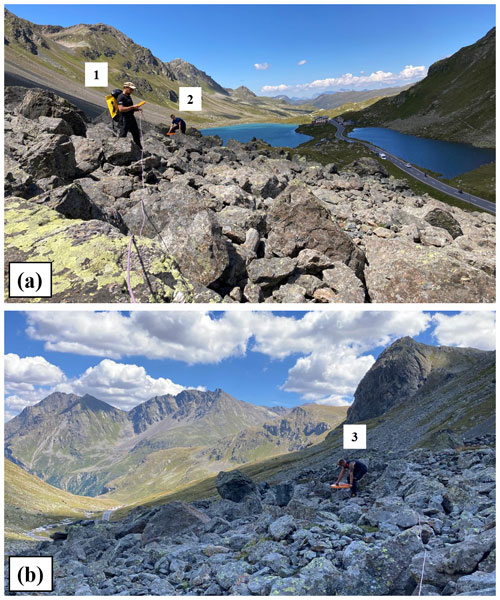
Brief communication: On the potential of dual-coil frequency-domain electromagnetic (FDEM) systems to detect frozen layers in mountain permafrost environments

Mauro Guglielmin
Alexander Bast
Stefano Ponti
Emanuele Forte
Alberto Carrera
Luca Peruzzo
Simone Peracchi
Giorgio Cassiani
Jacopo Boaga
Frequency Domain Electromagnetic (FDEM) methods are still rarely applied in mountain permafrost environments, such as rock glaciers. Here, we test a separable dual-coil FDEM system at four alpine permafrost sites and compare the results with Electrical Resistivity Tomography (ERT), the most commonly used geophysical method applied in these environments. The comparison shows that FDEM can reproduce key subsurface features identified by ERT and highlights the potential of separable dual-coil FDEM systems for a straightforward, preliminary, first-order assessment of subsurface structures in mountain permafrost environments.
- Article
(1544 KB) - Full-text XML
-
Supplement
(921 KB) - BibTeX
- EndNote


Rock glaciers are widespread landforms in Alpine regions and can be used as proxies for the presence of mountain permafrost. Their internal structure is typically highly complex and heterogeneous, consisting of varying proportions of ice, liquid water, coarse blocks and debris, finer sediments, and air-filled voids, which challenges subsurface characterization (Phillips et al., 2023). Geophysical methods are commonly used to investigate the internal structure of rock glaciers in a non-invasive manner. Among these, Electrical Resistivity Tomography (ERT) is the most widely employed technique due to its sensitivity to frozen ground and ice-rich layers (Herring and Lewkowicz, 2022). However, ERT surveys in rock glacier environments are often logistically demanding, time-consuming, and prone to issues with electrode-ground galvanic contact, particularly in coarse-blocky terrains (Pavoni et al., 2022). These limitations motivate the exploration of alternative geophysical methods that are better suited for rapid and preliminary subsurface mapping and characterization.
The Frequency Domain Electromagnetic (FDEM) technique is commonly used in near-surface geophysics to easily and rapidly map subsurface electrical properties without requiring galvanic contact with the ground surface (Boaga, 2017). However, its application in mountain permafrost environments remains limited due to specific methodological uncertainties and challenges, first and foremost the difficulty in inducing secondary eddy currents in highly resistive layers (i.e., frozen ground and dry rock) (Hauck and Kneisel, 2008). Recently, FDEM has been applied by Boaga et al. (2020) and Pavoni et al. (2021) to estimate the active layer thickness of rock glaciers, and by Pavoni et al. (2023) to investigate the internal structure of the Calderone glacieret, although strong limitations in the quantitative characterization of the electrical resistivity of the frozen subsurface remain.
This study investigates the applicability of a separable dual-coil FDEM system across four Alpine sites characterized by distinct permafrost-related landforms, aiming to assess its potential for reconstructing subsurface structures. The FDEM results were compared with ERT profiles acquired at the same locations. The findings demonstrate the effectiveness of the dual-coil FDEM system as a reliable and logistically efficient tool for preliminary subsurface investigations and for detecting frozen layers in mountain permafrost environments, while highlighting its perspectives and current limitations.
The FDEM dual-coil method was evaluated across four sites near Flüela Pass (Grisons, Switzerland) and Stelvio Pass (Central Alps, Italy), selected to represent contrasting evolutionary stages of Alpine permafrost landforms. At Flüela Pass, the active rock glacier features heterogeneous metamorphic blocks and debris (mainly amphibolite and paragneiss) with patches of fine sediments. In its central area (previously surveyed by Boaga et al., 2024 and Bast et al., 2024), we acquired a 94 m ERT profile (48 electrodes at 2 m spacing) and a co-located 50 m FDEM transect with 10 sampling points (Fig. 1a). At Stelvio Pass, the active rock glacier comprises metamorphic blocks (ortho and paragneiss) and scree deposits overlying subordinate ablation till, with previous studies suggesting a massive ice core (Etzelmüller et al., 2020). Here, ERT (48 electrodes at 5 m spacing) was paired with 16 FDEM stations spaced along a 140 m line (Fig. 1b). Nearby, on a south-facing slope at Le Rese di Scorluzzo, an inactive rock glacier and an adjacent inactive protalus rampart were surveyed (Guglielmin and Tellini, 1992). ERT lines (48 electrodes at 3 m spacing) were matched with FDEM measurement points at 6 m intervals (Fig. 1c–d).
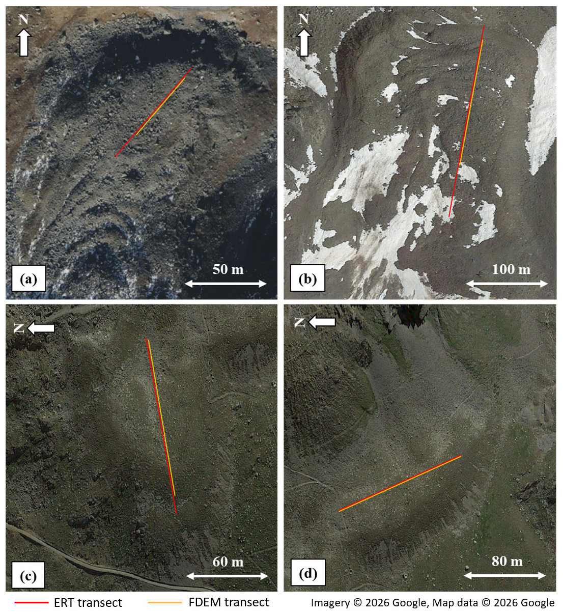
Figure 1Satellite images of the study sites showing the ERT (red lines) and FDEM (orange lines) survey profiles. (a) Active rock glacier at Flüela Pass (Switzerland; 46.746° N, 9.951° E). (b) Active rock glacier at Stelvio Pass (Italy; 46.527° N, 10.441° E). (c) Le Rese di Scorluzzo inactive rock glacier at Stelvio Pass (Italy; 46.531° N, 10.420° E). (d) Le Rese di Scorluzzo inactive protalus rampart at Stelvio Pass (Italy; 46.530° N, 10.421° E). Background imagery: Imagery © 2026 Google, Map data © 2026 Google (accessed via QuickMapServices in QGIS).
The FDEM technique, based on Maxwell's electromagnetic induction equations, allows the estimation of subsurface electrical resistivity without direct galvanic contact with the ground. FDEM systems consist of a transmitter coil that generates a time-varying magnetic field, inducing eddy currents in the subsurface which, in turn, produce a secondary magnetic field recorded by a receiver coil. Under the low-induction-number (LIN) approximation, the quadrature component of the secondary-to-primary magnetic field ratio is directly proportional to apparent conductivity (McNeill, 1980), where investigation depth and spatial resolution depend primarily on coil separation, orientation, and operating frequency. Lower frequencies and larger coil spacings increase sensitivity to deeper structures, whereas higher frequencies and shorter spacings enhance near-surface resolution. Furthermore, horizontal coplanar (HCP, coils parallel to the ground surface) and vertical coplanar (VCP, coils orthogonal to the ground surface) configurations sample distinct depth ranges (Pavoni et al., 2023). Operationally, since galvanic coupling is not required, once the coils are set at the optimal spacing and orientation, FDEM measurements can be acquired near-instantaneously at each station, enabling efficient coverage of extensive areas or challenging terrains without laying out cables or planting electrodes. Finally, apparent resistivity datasets are inverted into 1D vertical resistivity profiles by iteratively adjusting the model until calculated responses match observed data within an acceptable error threshold (Wagner and Uhlemann, 2021).
Electrical Resistivity Tomography (ERT) surveys were carried out using a Syscal-Pro (Iris Instruments) resistivity meter. 1250 quadrupoles were acquired using a hybrid acquisition scheme combining dipole–dipole and multi-gradient multi-skip arrays (Pavoni et al., 2025). Measurements were stacked three times, and all quadrupoles were acquired in direct and reciprocal configuration for reliable data quality assessment (Binley and Slater, 2020). In the blocky rock glaciers of Flüela Pass and Stelvio Pass, textile electrodes (Bast et al., 2025) and steel-net electrodes (Pavoni et al., 2025), wetted with salt water, were used. In the Le Rese di Scorluzzo sites, characterized by finer-grained surface sediments, traditional steel-spike electrodes were used. A dataset-specific filtering procedure was applied to each ERT survey. Quadrupoles with stacking and/or reciprocal errors above 5 % were removed, and the same value was used as the expected data error in the inversion process. Inversion modelling was performed using the open-source Python software ResIPy (Blanchy et al., 2020). All models reached a final RMS misfit close to 1 in a few iterations, indicating a good fit between observed and calculated apparent resistivities. Model sensitivity was used to define the lateral and vertical limits of the presented resistivity models, with low-sensitivity areas indicating portions of the model mainly constrained by regularization rather than by data (Fig. S2 in the Supplement).
FDEM measurements were collected with a CMD-DUO system (GF Instruments, 925 Hz) at three standard coil spacings (10, 20, and 40 m), using a thin (3 mm) connection cable specific to each distance. At each location, measurements were acquired manually and instantaneously once the coils were correctly positioned at the required spacing, orientation, and elevation for the selected configuration (e.g., as shown in Fig. S1 of the Supplement for the 40 m coil spacing in HCP orientation), with the connecting cable oriented orthogonally to the direction of the ERT line. Data were collected using the HCP configuration along the entire length of each FDEM transect (see Fig. 1), whereas the VCP configuration was only tested at selected points. Measurement errors were evaluated through signal stacking, and the position of each point was approximated as the midpoint between the two coils, corresponding to the location of the data logger with its integrated GPS (e.g., Fig. S1). However, for the profiles acquired on the rock glaciers at Flüela Pass, Stelvio Pass, and Le Rese di Scorluzzo (Fig. 1a–c), the FDEM transects do not cover the full length of the corresponding ERT lines. This limitation stemmed from the challenge of maintaining proper coil spacing, elevation, and alignment across highly irregular topography and steep slopes, issues that could have been mitigated had the survey not been constrained to strictly follow the ERT line geometries.
For each site and HCP configuration (10, 20, and 40 m coil spacings), the raw FDEM apparent resistivity data were smoothed using a one-dimensional horizontal Gaussian filter (σ=2) to reduce high-frequency noise while preserving the main lateral variations. The inversion modelling was performed using the open-source Python software EMagPy (McLachlan et al., 2021), employing a 10-layer model of regular thickness extending to 24 m depth. This 10-layer model parameterization represents an optimal trade-off in the inversion framework: despite the limited number of coil spacings, the smoothness-constrained inversion mitigates non-uniqueness by providing the necessary vertical flexibility to map continuous resistivity gradients while preventing unphysical numerical oscillations. The bottom of the model was defined based on the sensitivity analysis of the surveys (Fig. S3 in the Supplement). While a sensitivity threshold of 70 % is commonly adopted for the largest coil spacing (van't Veen et al., 2022), a higher value of 80 % was used in this study due to the challenging field conditions and the high-resistivity subsurface, which limit the induction of secondary eddy currents. A linearized inversion with L2-norm regularization, solved using the L-BFGS-B algorithm, was employed to iteratively update the model and minimize the misfit between observed and predicted apparent resistivities. The optimal regularization parameter was defined using the L-curve method, and the quality of the final model was evaluated using the Root Mean Square Percentage Error (RMSPE). Although RMSPE values below 5 % are generally considered acceptable, in this study a threshold of 10 % was adopted to account for the high-resistivity environment, measurement stacking errors (approx. 10 %), and the practical difficulties in optimally positioning the coils over complex topography and rough surfaces.
Figure 2 shows the ERT resistivity models for the survey sites. At the active Flüela rock glacier (Fig. 2a; 1035 quadrupoles retained after filtering out of 1250 total), a shallow high-resistivity layer (∼ 60–80 kΩ m, ∼ 5 m depth) extends from the upper (southern) section toward the frontal zone (north), with a thickness of ∼ 10 m that gradually thins toward the front and shows a discontinuity at ∼ 45 m along the profile. A comparable structure occurs at the active Stelvio Pass rock glacier (Fig. 2b; 870 retained quadrupoles), where the high-resistivity layer shows higher values (80–100 kΩ m) and greater thickness (15–30 m). In both cases, the morphology and high-resistivity layer indicate ice-bearing permafrost.
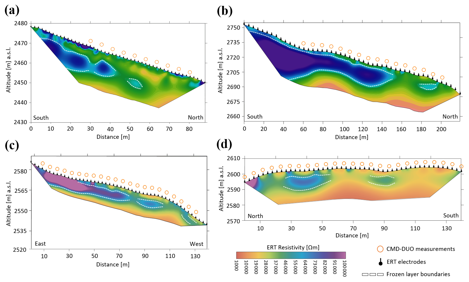
Figure 2Inverted resistivity models obtained from ERT measurements at (a) the active rock glacier at Flüela Pass, (b) the active rock glacier at Stelvio Pass, (c) Le Rese di Scorluzzo inactive rock glacier, and (d) the Le Rese di Scorluzzo inactive protalus rampart at Stelvio Pass. The positions of the ERT electrodes (black point marker with stem) along the transects and the measurement points acquired with the CMD-DUO FDEM system (orange circle) are shown. The white dashed lines indicate the interpreted boundary of the inferred frozen layer.
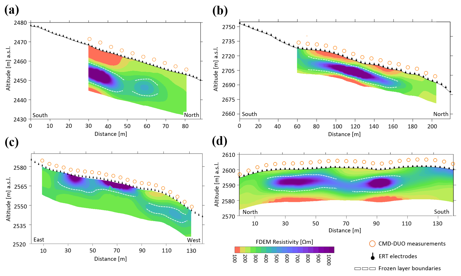
Figure 3Pseudo-2D inverted resistivity models obtained from FDEM data acquired with the CMD-DUO in HCP configuration at the sites of (a) active rock glacier at Flüela Pass (RMSPE: 7.88 %), (b) active rock glacier at Stelvio Pass (RMSPE: 7.36 %), (c) Le Rese di Scorluzzo inactive rock glacier (RMSPE: 4.03 %), and (d) the Le Rese di Scorluzzo inactive protalus rampart at Stelvio Pass (RMSPE: 6.18 %). The positions of the FDEM measurement points are marked with orange circles, and the white dashed lines indicate the inferred boundary of the frozen layer.
At the Le Rese di Scorluzzo sites, despite surface morphology and vegetation suggesting the possible absence of permafrost, ERT resistivity models reveal high-resistivity layers characteristic of a frozen subsurface. In the inactive rock glacier model (Fig. 2c; 790 retained quadrupoles), the top of the high-resistivity layer lies very close to the surface, making it difficult to distinguish from overlying air-filled material, whereas its boundary with underlying low-resistivity unfrozen sediment is distinct. In the inactive protalus rampart (Fig. 2d; 995 retained quadrupoles), a discontinuous high-resistivity layer is detected at 5–10 m depth in the central area, likely representing a frozen layer.
Figure 3 shows the FDEM inversion results. The pseudo-2D models were generated by kriging 1D vertical resistivity profiles inverted at each measurement station (orange circles, Figs. 2 and 3). Across all sites, FDEM models reproduce the main ERT resistivity patterns, although absolute resistivity values are, as expected, systematically lower. At the active Flüela Pass and Stelvio Pass rock glaciers (Fig. 3a–b), a more resistive layer (∼ 500–1000 Ω m) is clearly bounded between two less resistive layers (∼ 100–300 Ω m) and, as in the ERT models, thins and disappears toward the front. At Flüela Pass, the same ∼ 45–50 m discontinuity detected in the ERT model is evident. Similarly, at Le Rese di Scorluzzo (Fig. 3c–d), FDEM-derived structures closely mirror ERT results, indicating high-resistivity layers and suggesting a discontinuous frozen layer at both sites.
The results demonstrate that a separable dual-coil FDEM system (925 kHz, 10–40 m coil spacings, HCP) can reconstruct reliable subsurface structures in mountain permafrost. FDEM-derived resistivity models consistently reproduce main ERT patterns despite systematically lower absolute resistivity values and spatial resolution. This discrepancy is reasonable considering preferential EM propagation in conductive media (Boaga, 2017), the 10 kΩ ⋅ m instrumental sensitivity limit (Gf-instrument datasheet), limited spatial resolution for fine heterogeneities (Carrera et al., 2024), and synthetic modelling constraints. In this context, Pavoni et al. (2023) demonstrated that while this system has limited ability to resolve correct absolute resistivity values in highly resistive frozen layers, it accurately captures overall subsurface structures.
VCP measurements yielded poor results, characterized by high stacking errors (>100 %), apparent resistivities up to an order of magnitude lower than HCP values, and strongly negative in-phase responses. These effects stem from poor signal quality: VCP primary field orientation is less favourable for subsurface penetration than HCP, where primary fields couple more efficiently to induce eddy currents. Pavoni et al. (2021) reported similar VCP limitations in rock glacier active-layer investigations. Excluding VCP reduces vertical measurements per station, decreasing vertical resolution; however, given the poor data quality and doubled acquisition time, acquiring VCP data is not justified. Instead, survey efficiency and lateral resolution can be improved by focusing exclusively on HCP and increasing spatial density. Although intermediate coil spacings could theoretically enhance vertical resolution in inversion models, standard cables (10, 20, and 40 m) ensure operational robustness on complex rock glacier terrain. Furthermore, while continuous FDEM acquisition would accelerate data collection and increase sampling density, irregular surfaces prevent stable antenna positioning while walking. Consequently, station-to-station manual HCP measurements represent the most practical strategy, provided precise geometry is maintained. In our surveys, severe topography and strict adherence to the ERT transect constrained antenna placement in certain positions; however, this limitation is not intrinsic to the method and can be avoided in unconstrained mapping.
Logistically, the low weight of the dual-coil FDEM system (∼ 5 kg per antenna, ∼ 1 kg logger, ∼ 5 kg cables) enables deployment by small teams (2–3 operators) without the substantial effort required for ERT. Future work aims to leverage single ERT transects to calibrate extensive pseudo-3D FDEM mapping (McLachlan et al., 2021), optimizing logistics for large-scale permafrost characterization and yielding a more consistent resistivity range between inverted models.
Overall, despite inherent vertical spatial resolution limitations from using only three measurement configurations per location, which exacerbates the non-uniqueness of the geophysical problem, and a 10-layer model setup that cannot resolve sharp physical boundaries, the proposed workflow demonstrates high potential for large-scale qualitative to semiquantitative mountain permafrost mapping in remote areas. Thanks to its ability to rapidly identify high-resistivity zones with minimal transport effort and straightforward processing, the dual-coil FDEM system can be introduced as an efficient preliminary tool to target optimal sites for subsequent, more laborious ERT and seismic surveys.
The datasets generated and analyzed during the current study are openly available in Zenodo at https://doi.org/10.5281/zenodo.22092969 (Pavoni, 2026). Data processing was carried out using the open-source Python software EMagPy v1.4.2 (McLachlan et al., 2021).
The supplement related to this article is available online at https://doi.org/10.5194/tc-20-5393-2026-supplement.
MP, MG, EF, JB developed the concept of the study; MP, AB, MG, SPo, JB were involved in the data acquisition; MP performed the data processing; all authors contributed to the writing and editing of the manuscript.
The contact author has declared that none of the authors has any competing interests.
Publisher's note: Copernicus Publications remains neutral with regard to jurisdictional claims made in the text, published maps, institutional affiliations, or any other geographical representation in this paper. The authors bear the ultimate responsibility for providing appropriate place names. Views expressed in the text are those of the authors and do not necessarily reflect the views of the publisher.
This article is part of the special issue “Emerging geophysical methods for permafrost investigations: recent advances in permafrost detecting, characterizing, and monitoring”. It is not associated with a conference.
We would like to thank Francesco Grifoni, Filippo Caccia, Elena Molteni, Edoardo Riva, and Claudio Bussolini from the Department of Theoretical and Applied Sciences, University of Insubria (Varese, Italy), as well as Ary Leonel Miño and Elisa Ligas from the Department of Mathematics, Informatics and Geosciences, University of Trieste (Trieste, Italy), for their participation in the measurement campaigns.
This study was carried out within the project of the excellence program: “The Geosciences for Sustainable Development” project (Budget Ministero dell'Università e della Ricerca–Dipartimenti di Eccellenza 2023–2027 C93C23002690001).
This paper was edited by Mohammad Farzamian and reviewed by Liam Nell, Sina Saneiyan, and two anonymous referees.
Bast, A., Pavoni, M., Lichtenegger, M., Buckel, J., and Boaga, J.: The Use of Textile Electrodes for Electrical Resistivity Tomography in Periglacial, Coarse Blocky Terrain: A Comparison With Conventional Steel Electrodes, Permafrost Periglac., 36, 110–122, https://doi.org/10.1002/ppp.2257, 2025.
Binley, A. and Slater, L.: Resistivity and induced polarization: Theory and applications to the near-surface earth, Cambridge University Press, https://doi.org/10.1017/9781108685955, 2020.
Blanchy, G., Saneiyan, S., Boyd, J., McLachlan, P., and Binley, A.: ResIPy, an intuitive open source software for complex geoelectrical inversion/modeling, Comput. Geosci., 137, 104423, https://doi.org/10.1016/j.cageo.2020.104423, 2020.
Boaga, J.: The use of FDEM in hydrogeophysics: A review, J. Appl. Geophys., 139, 36–46, https://doi.org/10.1016/j.jappgeo.2017.02.011, 2017.
Boaga, J., Phillips, M., Noetzli, J., Haberkorn, A., Kenner, R., and Bast, A.: A comparison of frequency domain electro-magnetometry, electrical resistivity tomography and borehole temperatures to assess the presence of ice in a rock glacier, Front. Earth Sci., 8, 586430, https://doi.org/10.3389/feart.2020.586430, 2020.
Boaga, J., Pavoni, M., Bast, A., and Weber, S.: Brief communication: On the potential of seismic polarity reversal to identify a thin low-velocity layer above a high-velocity layer in ice-rich rock glaciers, The Cryosphere, 18, 3231–3236, https://doi.org/10.5194/tc-18-3231-2024, 2024.
Carrera, A., Peruzzo, L., Longo, M., Cassiani, G., and Morari, F.: Uncovering soil compaction: performance of electrical and electromagnetic geophysical methods, SOIL, 10, 843–857, https://doi.org/10.5194/soil-10-843-2024, 2024.
Etzelmüller, B, Guglielmin, M, Hauck, C., Hilbich, C., Hoelzle, M., Isaksen, K., Noetzli, J., Oliva, M., and Ramos, M.: Twenty years of European mountain permafrost dynamics-the PACE legacy, Environ. Res. Lett., 15, 104070, https://doi.org/10.1088/1748-9326/abae9d, 2020.
Guglielmin, M. and Tellini, C.: Contributo alla conoscenza dei rock glaciers delle Alpi italiane. I rock glaciers del Livignasco (Alta Valtellina), Rivista Geografica Italiana, 99, 395–414, 1992.
Hauck, C. and Kneisel, C.: Applied geophysics in periglacial environments, Cambridge University Press, ISBN 9780521889667, 2008.
Herring, T. and Lewkowicz, A. G.: A systematic evaluation of electrical resistivity tomography for permafrost interface detection using forward modeling, Permafrost Periglac., 33, 134–146, https://doi.org/10.1002/ppp.2141, 2022.
McLachlan, P., Blanchy, G., and Binley, A.: EMagPy: Open-source standalone software for processing, forward modeling and inversion of electromagnetic induction data, Comput. Geosci., 146, 104561, https://doi.org/10.1016/j.cageo.2020.104561, 2021.
McNeill, J. D.: Electromagnetic terrain conductivity measurement at low induction numbers, Geonics Ltd., Technical Note TN-6, Mississauga, Ontario, https://www.geonics.com/pdfs/technicalnotes/tn6.pdf (last access: 21 September 2026), 1980.
Pavoni, M.: Frequency Domain Electromagnetic (FDEM) datasets: Fluela Pass, Stelvio Pass, and Scorluzzo. Brief Communication EGUSPHERE-2026-1264, Zenodo [data set], https://doi.org/10.5281/zenodo.22092969, 2026.
Pavoni, M., Sirch, F., and Boaga, J.: Electrical and electromagnetic geophysical prospecting for the monitoring of rock glaciers in the Dolomites, Northeast Italy, Sensors, 21, 1294, https://doi.org/10.3390/s21041294, 2021.
Pavoni, M., Carrera, A., and Boaga, J.: Improving the galvanic contact resistance for geoelectrical measurements in debris areas: A case study, Near Surf. Geophys., 20, 178–191, https://doi.org/10.1002/nsg.12192, 2022.
Pavoni, M., Boaga, J., Carrera, A., Urbini, S., de Blasi, F., and Gabrieli, J.: Combining Ground Penetrating Radar and Frequency Domain Electromagnetic Surveys to Characterize the Structure of the Calderone Glacieret (Gran Sasso d'Italia, Italy), Remote Sensing, 15, 2615, https://doi.org/10.3390/rs15102615, 2023.
Pavoni, M., Peruzzo, L., Boaga, J., Carrera, A., Barone, I., and Bast, A.: Brief communication: Use of lightweight and low-cost steel net electrodes for electrical resistivity tomography (ERT) surveys performed on coarse-blocky surface environments, The Cryosphere, 19, 4141–4148, https://doi.org/10.5194/tc-19-4141-2025, 2025.
Phillips, M., Buchli, C., Weber, S., Boaga, J., Pavoni, M., and Bast, A.: Brief communication: Combining borehole temperature, borehole piezometer and cross-borehole electrical resistivity tomography measurements to investigate seasonal changes in ice-rich mountain permafrost, The Cryosphere, 17, 753–760, https://doi.org/10.5194/tc-17-753-2023, 2023.
van't Veen, K. M., Ferré, T. P. A., Iversen, B. V., and Børgesen, C. D.: Using machine learning to predict optimal electromagnetic induction instrument configurations for characterizing the shallow subsurface, Hydrol. Earth Syst. Sci., 26, 55–70, https://doi.org/10.5194/hess-26-55-2022, 2022.
Wagner, F. M. and Uhlemann, S.: An overview of multimethod imaging approaches in environmental geophysics, Adv. Geophys., 62, 1–72, 2021.
- Abstract
- Introduction
- Sites description
- Method: Frequency Domain Electromagnetic (FDEM)
- Data acquisition and processing
- Results
- Discussion and conclusions
- Data availability
- Author contributions
- Competing interests
- Disclaimer
- Special issue statement
- Acknowledgements
- Financial support
- Review statement
- References
- Supplement
- Abstract
- Introduction
- Sites description
- Method: Frequency Domain Electromagnetic (FDEM)
- Data acquisition and processing
- Results
- Discussion and conclusions
- Data availability
- Author contributions
- Competing interests
- Disclaimer
- Special issue statement
- Acknowledgements
- Financial support
- Review statement
- References
- Supplement