
Articles | Volume 20, issue 9
https://doi.org/10.5194/tc-20-5247-2026
© Author(s) 2026. This work is distributed under
the Creative Commons Attribution 4.0 License.
the Creative Commons Attribution 4.0 License.
https://doi.org/10.5194/tc-20-5247-2026
© Author(s) 2026. This work is distributed under
the Creative Commons Attribution 4.0 License.
the Creative Commons Attribution 4.0 License.
Research article
| 
21 Sep 2026
Research article |
| 21 Sep 2026
| 21 Sep 2026
Temporal evolution of the Petermann Ice Shelf estuary constrained by satellite remote sensing observations
Michela Savignano
CORRESPONDING AUTHOR

Department of Geography, University of Colorado Boulder, Boulder, 80309, USA
Cooperative Institute for Research in Environmental Sciences (CIRES), University of Colorado Boulder, Boulder, 80309, USA
Alison F. Banwell
Cooperative Institute for Research in Environmental Sciences (CIRES), University of Colorado Boulder, Boulder, 80309, USA
Centre for Polar Observation and Modelling (CPOM), School of Geography and Natural Sciences, Northumbria University, Newcastle Upon Tyne, UK
Waleed Abdalati
Department of Geography, University of Colorado Boulder, Boulder, 80309, USA
Cooperative Institute for Research in Environmental Sciences (CIRES), University of Colorado Boulder, Boulder, 80309, USA
Robin E. Bell
Lamont Doherty Earth Observatory (LDEO) of Columbia University, Palisades, 10964, USA
Alexandra Boghosian
Lamont Doherty Earth Observatory (LDEO) of Columbia University, Palisades, 10964, USA
W. Roger Buck
Lamont Doherty Earth Observatory (LDEO) of Columbia University, Palisades, 10964, USA
Department of Earth and Environmental Sciences, Columbia University, New York, NY 10025, USA
Sarah E. Esenther
Department of Earth, Planetary, and Environmental Sciences and Institute at Brown for Environment and Society, Brown University, Providence RI 02912
Emily Glazer
Lamont Doherty Earth Observatory (LDEO) of Columbia University, Palisades, 10964, USA
Department of Earth and Environmental Sciences, Columbia University, New York, NY 10025, USA
Adam L. LeWinter
US Army Corps of Engineers Cold Regions Research and Engineering Laboratory, Hanover, NH 03755 USA
Laurence C. Smith
Department of Earth, Planetary, and Environmental Sciences and Institute at Brown for Environment and Society, Brown University, Providence RI 02912
Leigh A. Stearns
Department of Earth and Environmental Science, University of Pennsylvania, Philadelphia, PA 19104 USA
Related authors
No articles found.
Emily C. Glazer and Kirsty J. Tinto
The Cryosphere, 20, 5131–5156, https://doi.org/10.5194/tc-20-5131-2026, https://doi.org/10.5194/tc-20-5131-2026, 2026
Short summary
Short summary
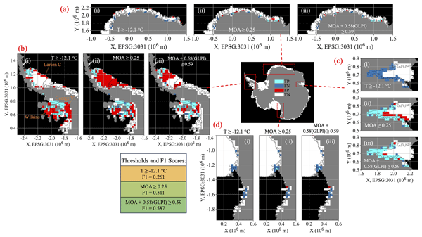
Surface meltwater ponds on Antarctic ice shelves can trigger ice break-up. Using satellite records of observed ponds along with temperatures, snowfall rates, and melt rates from climate models, we show that ponding occurs more widely than theory predicts. Our calibrated method identifies vulnerable areas more accurately and suggests pond coverage could be over double what standard methods predict by 2100, highlighting the need for careful evaluation of climate thresholds used to predict ponding.
Seebany Datta-Barua, Alison F. Banwell, Jonah Wilkes, Alec Weedman, Roohollah Parvizi, Christian Allen, Aiden Verdin, Hiroki Kawai, Logan Garcia, and Kristine M. Larson
EGUsphere, https://doi.org/10.5194/egusphere-2026-5057, https://doi.org/10.5194/egusphere-2026-5057, 2026
This preprint is open for discussion and under review for Geoscientific Instrumentation, Methods and Data Systems (GI).
Short summary
Short summary
We tested reflected Global Navigation Satellite System (GNSS) signals as a way to monitor glacier surfaces using the Antarctic ice shelf near McMurdo Station during the 2023–24 austral summer. We collected GNSS, lidar, and camera data from: snow-covered ice near Phoenix airfield, and a mixed surface of bare ice and snow-covered ice at the former Pegasus airfield. The directly-reflected GNSS signal was too weak to extract surface conditions. GNSS interferometry data do differ between the sites.
Emily Glen, Alison F. Banwell, Katie E. Miles, Amber A. Leeson, Rebecca L. Dell, Malcolm McMillan, and Jennifer Maddalena
The Cryosphere, 20, 4345–4365, https://doi.org/10.5194/tc-20-4345-2026, https://doi.org/10.5194/tc-20-4345-2026, 2026
Short summary
Short summary
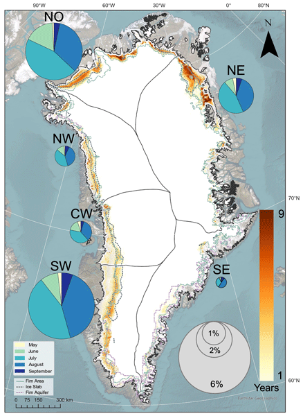
Using satellite imagery and machine learning, we created the first Greenland-wide dataset of slush (waterlogged snow) from 2016 to 2024. Slush was widespread and varied strongly between years and across Greenland, becoming most extensive during high melt seasons. It was most common where melting was greater and snow had less capacity to store water. These findings show that slush should be included in models of future melting and sea-level rise.
Kevin Shionalyn, Ginny Catania, Daniel T. Trugman, Michael G. Shahin, Leigh A. Stearns, and Denis Felikson
The Cryosphere, 20, 1725–1744, https://doi.org/10.5194/tc-20-1725-2026, https://doi.org/10.5194/tc-20-1725-2026, 2026
Short summary
Short summary
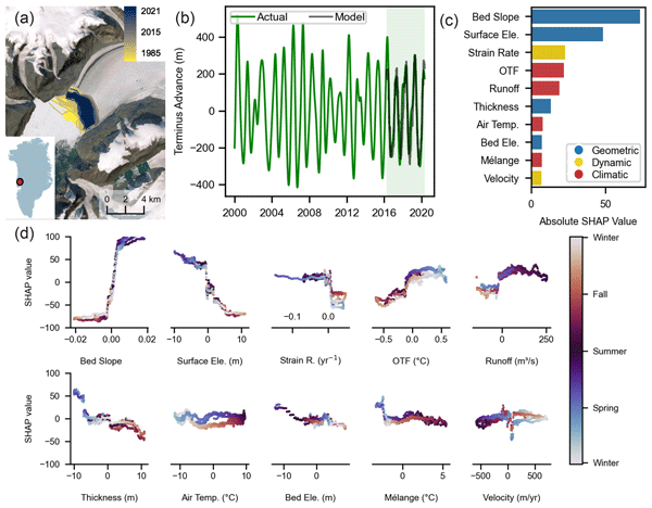
The ocean-facing front of a glacier changes with the seasons. We know this cycle is controlled by the shape and speed of the glacier as well as by the climate, but we do not have a full understanding of these processes. Our study uses 20 years of data and a machine learning model to predict this pattern and identifies which factors matter most. We find that while several factors influence the seasonal cycle, the shape of the glacier plays a key role in how much a glacier changes annually.
Emily Glen, Amber Leeson, Alison F. Banwell, Jennifer Maddalena, Diarmuid Corr, Olivia Atkins, Brice Noël, and Malcolm McMillan
The Cryosphere, 19, 1047–1066, https://doi.org/10.5194/tc-19-1047-2025, https://doi.org/10.5194/tc-19-1047-2025, 2025
Short summary
Short summary
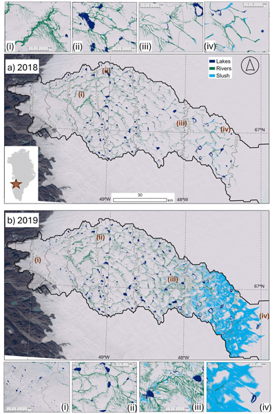
We compare surface meltwater features from optical satellite imagery in the Russell–Leverett glacier catchment during high (2019) and low (2018) melt years. In the high melt year, features appear at higher elevations, meltwater systems are more connected, small lakes are more frequent, and slush is more widespread. These findings provide insights into how a warming climate, where high melt years become common, could alter meltwater distribution and dynamics on the Greenland Ice Sheet.
Derek J. Pickell, Robert L. Hawley, and Adam LeWinter
The Cryosphere, 19, 1013–1029, https://doi.org/10.5194/tc-19-1013-2025, https://doi.org/10.5194/tc-19-1013-2025, 2025
Short summary
Short summary
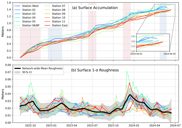
We use a low-cost, low-power GNSS network to measure surface accumulation in Greenland's interior using the interferometric reflectometry technique. Additionally, we extend this method to also estimate centimeter- to meter-scale surface roughness. Our results closely align with a validation record and highlight a period of unusually high accumulation from late 2022 to 2023, along with seasonal variations in surface roughness.
Sonam F. Sherpa, Laurence C. Smith, Bo Wang, and Cassie Stuurman
EGUsphere, https://doi.org/10.5194/egusphere-2025-133, https://doi.org/10.5194/egusphere-2025-133, 2025
Preprint archived
Short summary
Short summary
As the climate warms, glaciers in the Himalayas are melting and retreating, creating new lakes that are often held back by ice or loose rock. These lakes can suddenly burst, causing devastating floods. On August 16, 2024, such a flood occurred unexpectedly in Nepal's Bhotekoshi River Valley, near Mount Everest. We highlight how modern technologies can play a crucial role in detecting potential dangers and helping communities prepare for risks in a changing climate.
W. Roger Buck
The Cryosphere, 18, 4165–4176, https://doi.org/10.5194/tc-18-4165-2024, https://doi.org/10.5194/tc-18-4165-2024, 2024
Short summary
Short summary
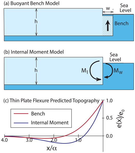
Standard theory predicts that the edge of an ice shelf should bend downward. Satellite observations show that the edges of many ice shelves bend upward. A new theory for ice shelf bending is developed that, for the first time, includes the kind of vertical variations in ice flow properties expected for ice shelves. Upward bending of shelf edges is predicted as long as the ice surface is very cold and the ice flow properties depend strongly on temperature.
Naomi E. Ochwat, Ted A. Scambos, Alison F. Banwell, Robert S. Anderson, Michelle L. Maclennan, Ghislain Picard, Julia A. Shates, Sebastian Marinsek, Liliana Margonari, Martin Truffer, and Erin C. Pettit
The Cryosphere, 18, 1709–1731, https://doi.org/10.5194/tc-18-1709-2024, https://doi.org/10.5194/tc-18-1709-2024, 2024
Short summary
Short summary
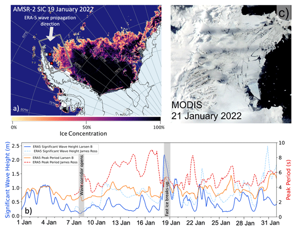
On the Antarctic Peninsula, there is a small bay that had sea ice fastened to the shoreline (
fast ice) for over a decade. The fast ice stabilized the glaciers that fed into the ocean. In January 2022, the fast ice broke away. Using satellite data we found that this was because of low sea ice concentrations and a high long-period ocean wave swell. We find that the glaciers have responded to this event by thinning, speeding up, and retreating by breaking off lots of icebergs at remarkable rates.
Prateek Gantayat, Alison F. Banwell, Amber A. Leeson, James M. Lea, Dorthe Petersen, Noel Gourmelen, and Xavier Fettweis
Geosci. Model Dev., 16, 5803–5823, https://doi.org/10.5194/gmd-16-5803-2023, https://doi.org/10.5194/gmd-16-5803-2023, 2023
Short summary
Short summary
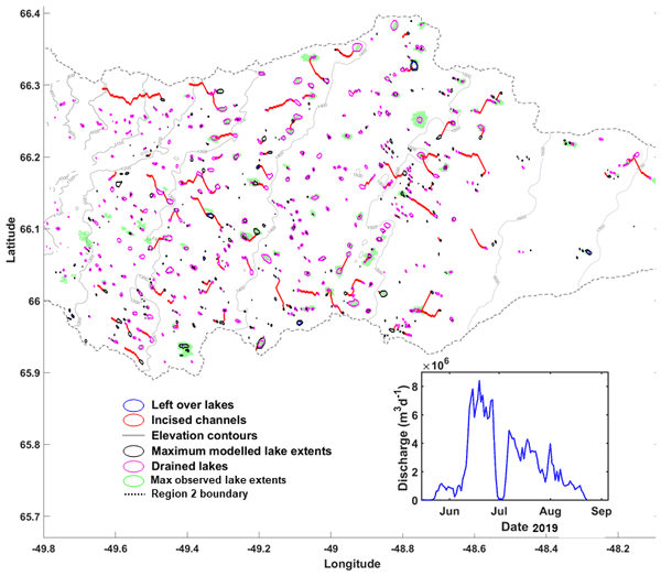
We developed a new supraglacial hydrology model for the Greenland Ice Sheet. This model simulates surface meltwater routing, meltwater drainage, supraglacial lake (SGL) overflow, and formation of lake ice. The model was able to reproduce 80 % of observed lake locations and provides a good match between the observed and modelled temporal evolution of SGLs.
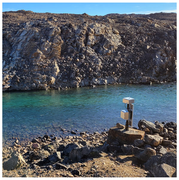
Sarah E. Esenther, Laurence C. Smith, Adam LeWinter, Lincoln H. Pitcher, Brandon T. Overstreet, Aaron Kehl, Cuyler Onclin, Seth Goldstein, and Jonathan C. Ryan
Geosci. Instrum. Method. Data Syst., 12, 215–230, https://doi.org/10.5194/gi-12-215-2023, https://doi.org/10.5194/gi-12-215-2023, 2023
Short summary
Short summary
Meltwater runoff estimates from the Greenland ice sheet contain uncertainty. To better understand ice sheet hydrology, we installed a weather station and river stage sensors along three proglacial rivers in a cold-bedded area of NW Greenland without firn, crevasse, or moulin influence. The first 3 years (2019–2021) of observations have given us a first look at the seasonal and annual weather and hydrological patterns of this understudied region.
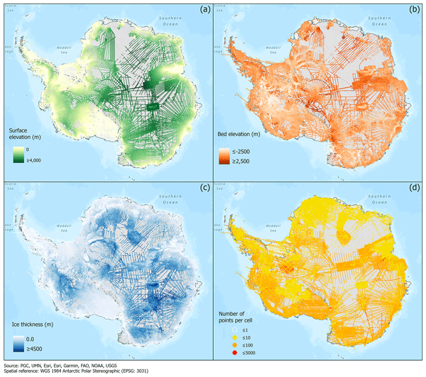
Alice C. Frémand, Peter Fretwell, Julien A. Bodart, Hamish D. Pritchard, Alan Aitken, Jonathan L. Bamber, Robin Bell, Cesidio Bianchi, Robert G. Bingham, Donald D. Blankenship, Gino Casassa, Ginny Catania, Knut Christianson, Howard Conway, Hugh F. J. Corr, Xiangbin Cui, Detlef Damaske, Volkmar Damm, Reinhard Drews, Graeme Eagles, Olaf Eisen, Hannes Eisermann, Fausto Ferraccioli, Elena Field, René Forsberg, Steven Franke, Shuji Fujita, Yonggyu Gim, Vikram Goel, Siva Prasad Gogineni, Jamin Greenbaum, Benjamin Hills, Richard C. A. Hindmarsh, Andrew O. Hoffman, Per Holmlund, Nicholas Holschuh, John W. Holt, Annika N. Horlings, Angelika Humbert, Robert W. Jacobel, Daniela Jansen, Adrian Jenkins, Wilfried Jokat, Tom Jordan, Edward King, Jack Kohler, William Krabill, Mette Kusk Gillespie, Kirsty Langley, Joohan Lee, German Leitchenkov, Carlton Leuschen, Bruce Luyendyk, Joseph MacGregor, Emma MacKie, Kenichi Matsuoka, Mathieu Morlighem, Jérémie Mouginot, Frank O. Nitsche, Yoshifumi Nogi, Ole A. Nost, John Paden, Frank Pattyn, Sergey V. Popov, Eric Rignot, David M. Rippin, Andrés Rivera, Jason Roberts, Neil Ross, Anotonia Ruppel, Dustin M. Schroeder, Martin J. Siegert, Andrew M. Smith, Daniel Steinhage, Michael Studinger, Bo Sun, Ignazio Tabacco, Kirsty Tinto, Stefano Urbini, David Vaughan, Brian C. Welch, Douglas S. Wilson, Duncan A. Young, and Achille Zirizzotti
Earth Syst. Sci. Data, 15, 2695–2710, https://doi.org/10.5194/essd-15-2695-2023, https://doi.org/10.5194/essd-15-2695-2023, 2023
Short summary
Short summary
This paper presents the release of over 60 years of ice thickness, bed elevation, and surface elevation data acquired over Antarctica by the international community. These data are a crucial component of the Antarctic Bedmap initiative which aims to produce a new map and datasets of Antarctic ice thickness and bed topography for the international glaciology and geophysical community.
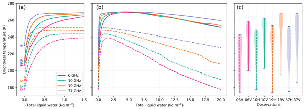
Ghislain Picard, Marion Leduc-Leballeur, Alison F. Banwell, Ludovic Brucker, and Giovanni Macelloni
The Cryosphere, 16, 5061–5083, https://doi.org/10.5194/tc-16-5061-2022, https://doi.org/10.5194/tc-16-5061-2022, 2022
Short summary
Short summary
Using a snowpack radiative transfer model, we investigate in which conditions meltwater can be detected from passive microwave satellite observations from 1.4 to 37 GHz. In particular, we determine the minimum detectable liquid water content, the maximum depth of detection of a buried wet snow layer and the risk of false alarm due to supraglacial lakes. These results provide information for the developers of new, more advanced satellite melt products and for the users of the existing products.
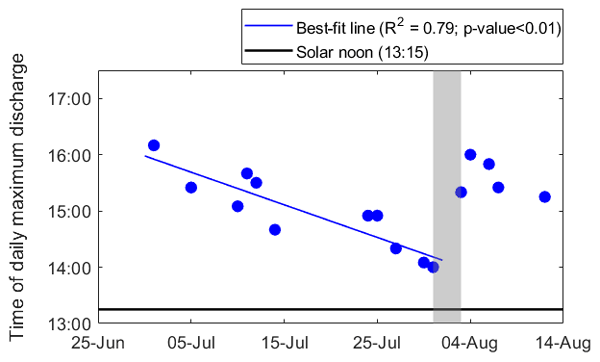
Rohi Muthyala, Åsa K. Rennermalm, Sasha Z. Leidman, Matthew G. Cooper, Sarah W. Cooley, Laurence C. Smith, and Dirk van As
The Cryosphere, 16, 2245–2263, https://doi.org/10.5194/tc-16-2245-2022, https://doi.org/10.5194/tc-16-2245-2022, 2022
Short summary
Short summary
In situ measurements of meltwater discharge through supraglacial stream networks are rare. The unprecedentedly long record of discharge captures diurnal and seasonal variability. Two major findings are (1) a change in the timing of peak discharge through the melt season that could impact meltwater delivery in the subglacial system and (2) though the primary driver of stream discharge is shortwave radiation, longwave radiation and turbulent heat fluxes play a major role during high-melt episodes.
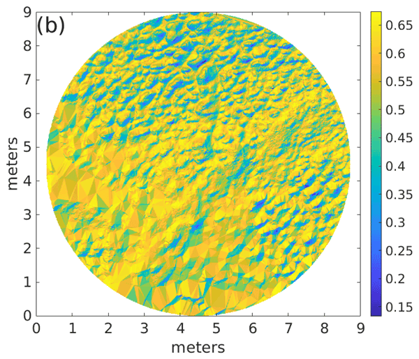
Edward H. Bair, Jeff Dozier, Charles Stern, Adam LeWinter, Karl Rittger, Alexandria Savagian, Timbo Stillinger, and Robert E. Davis
The Cryosphere, 16, 1765–1778, https://doi.org/10.5194/tc-16-1765-2022, https://doi.org/10.5194/tc-16-1765-2022, 2022
Short summary
Short summary
Understanding how snow and ice reflect solar radiation (albedo) is important for global climate. Using high-resolution topography, darkening from surface roughness (apparent albedo) is separated from darkening by the composition of the snow (intrinsic albedo). Intrinsic albedo is usually greater than apparent albedo, especially during melt. Such high-resolution topography is often not available; thus the use of a shade component when modeling mixtures is advised.
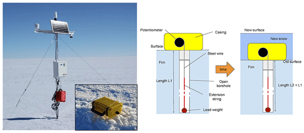
Michael J. MacFerrin, C. Max Stevens, Baptiste Vandecrux, Edwin D. Waddington, and Waleed Abdalati
Earth Syst. Sci. Data, 14, 955–971, https://doi.org/10.5194/essd-14-955-2022, https://doi.org/10.5194/essd-14-955-2022, 2022
Short summary
Short summary
The vast majority of the Greenland ice sheet's surface is covered by pluriannual snow, also called firn, that accumulates year after year and is compressed into glacial ice. The thickness of the firn layer changes through time and responds to the surface climate. We present continuous measurement of the firn compaction at various depths for eight sites. The dataset will help to evaluate firn models, interpret ice cores, and convert remotely sensed ice sheet surface height change to mass loss.
Cited articles
Andreasen, J. R., Hogg, A. E., and Selley, H. L.: Change in Antarctic ice shelf area from 2009 to 2019, The Cryosphere, 17, 2059–2072, https://doi.org/10.5194/tc-17-2059-2023, 2023.
Banwell, A.: Ice-shelf stability questioned, Nature, 544, 306–307, https://doi.org/10.1038/544306a, 2017.
Banwell, A. F., MacAyeal, D. R., and Sergienko, O. V.: Breakup of the Larsen B Ice Shelf triggered by chain reaction drainage of supraglacial lakes, Geophys. Res. Lett., 40, 5872–5876, https://doi.org/10.1002/2013GL057694, 2013.
Banwell, A. F., Willis, I. C., Macdonald, G. J., Goodsell, B., and MacAyeal, D. R.: Direct measurements of ice-shelf flexure caused by surface meltwater ponding and drainage, Nat. Commun., 10, 730, https://doi.org/10.1038/s41467-019-08522-5, 2019.
Banwell, A. F., Wever, N., Dunmire, D., and Picard, G.: Quantifying Antarctic-Wide Ice-Shelf Surface Melt Volume Using Microwave and Firn Model Data: 1980 to 2021, Geophys. Res. Lett., 50, https://doi.org/10.1029/2023GL102744, 2023.
Bell, R. E., Chu, W., Kingslake, J., Das, I., Tedesco, M., Tinto, K. J., Zappa, C. J., Frezzotti, M., Boghosian, A., and Lee, W. S.: Antarctic ice shelf potentially stabilized by export of meltwater in surface river, Nature, 544, 344–348, https://doi.org/10.1038/nature22048, 2017.
Bell, R. E., Banwell, A. F., Trusel, L. D., and Kingslake, J.: Antarctic surface hydrology and impacts on ice-sheet mass balance, Nature Clim. Change, 8, 1044–1052, https://doi.org/10.1038/s41558-018-0326-3, 2018.
Boghosian, A. L.: Ice-Shelf Stability: New Insights into Rivers and Estuaries Using Remote Sensing and Advanced Visualization, Ph.D., Columbia University, United States – New York, 168 pp., https://www.proquest.com/dissertations-theses/ice-shelf-stability-new-insights-into-rivers/docview/2508100970/se-2 (last access: 26 July 2026), 2021.
Boghosian, A. L., Pitcher, L. H., Smith, L. C., Kosh, E., Alexander, P. M., Tedesco, M., and Bell, R. E.: Development of ice-shelf estuaries promotes fractures and calving, Nat. Geosci., 14, 899–905, https://doi.org/10.1038/s41561-021-00837-7, 2021.
Chartrand, A. M. and Howat, I. M.: A comparison of contemporaneous airborne altimetry and ice-thickness measurements of Antarctic ice shelves, J. Glaciol., 69, 1663–1676, https://doi.org/10.1017/jog.2023.49, 2023.
Chavez, P. S.: Image-Based Atmospheric Corrections – Revisited and Improved, Photogrammetric Engineering and Remote Sensing, 62, 1025–1036, https://static1.1.sqspcdn.com/static/f/891472/15133582/1321370214637/Chavez_P.S._1996.pdf (last access: 14 September 2026), 1996.
Chudley, T. R. and Howat, I. M.: pDEMtools: conveniently search, download, and processArcticDEM and REMA products, J. Open Source Softw., 9, 7149, https://doi.org/10.21105/joss.07149, 2024.
Ciracì, E., Rignot, E., Scheuchl, B., Tolpekin, V., Wollersheim, M., An, L., Milillo, P., Bueso-Bello, J.-L., Rizzoli, P., and Dini, L.: Melt rates in the kilometer-size grounding zone of Petermann Glacier, Greenland, before and during a retreat, P. Natl. Acad. Sci. USA, 120, https://doi.org/10.1073/pnas.2220924120, 2023.
Dai, C., Durand, M., Howat, I. M., Altenau, E. H., and Pavelsky, T. M.: Estimating River Surface Elevation From ArcticDEM, Geophys. Res. Lett., 45, 3107–3114, https://doi.org/10.1002/2018GL077379, 2018.
Datta, R. T. and Wouters, B.: Supraglacial lake bathymetry automatically derived from ICESat-2 constraining lake depth estimates from multi-source satellite imagery, The Cryosphere, 15, 5115–5132, https://doi.org/10.5194/tc-15-5115-2021, 2021.
Dow, C. F., Lee, W. S., Greenbaum, J. S., Greene, C. A., Blankenship, D. D., Poinar, K., Forrest, A. L., Young, D. A., and Zappa, C. J.: Basal channels drive active surface hydrology and transverse ice shelf fracture, Sci. Adv., 4, https://doi.org/10.1126/sciadv.aao7212, 2018.
Ester, M., Kriegel, H.-P., Sander, J., and Xu, X.: A density-based algorithm for discovering clusters in large spatial databases with noise, Proceedings of the Second International Conference on Knowledge Discovery and Data Mining, KDD'96, Portland, Oregon, August 2–4 1996, 226–231, AAAI Press, https://cdn.aaai.org/KDD/1996/KDD96-037.pdf (last access: 24 November 2025), 1996.
Fettweis, X.: Modèle Atmosphérique Régional (MAR) version 3.11 regional climate model output, 1979–2019, Greenland domain, 10 kilometer (km) horizontal resolution, https://doi.org/10.18739/A28G8FJ7F, 2022.
Fettweis, X. and Grailet, J.-F.: MAR (Modèle Atmosphérique Régional) version 3.14, Zenodo [code], https://doi.org/10.5281/zenodo.13151275, 2024.
Fountain, A. G. and Walder, J. S.: Water flow through temperate glaciers, Rev. Geophys., 36, 299–328, https://doi.org/10.1029/97RG03579, 1998.
Fricker, H. A., Arndt, P., Brunt, K. M., Datta, R. T., Fair, Z., Jasinski, M. F., Kingslake, J., Magruder, L. A., Moussavi, M., Pope, A., Spergel, J. J., Stoll, J. D., and Wouters, B.: ICESat-2 Meltwater Depth Estimates: Application to Surface Melt on Amery Ice Shelf, East Antarctica, Geophys. Res. Lett., 48, https://doi.org/10.1029/2020GL090550, 2020.
Fürst, J. J., Durand, G., Gillet-Chaulet, F., Tavard, L., Rankl, M., Braun, M., and Gagliardini, O.: The safety band of Antarctic ice shelves, Nature Clim. Change, 6, 479–482, https://doi.org/10.1038/nclimate2912, 2016.
Geyer, W. R. and MacCready, P.: The Estuarine Circulation, Annu. Rev. Fluid Mech., 46, 175–197, https://doi.org/10.1146/annurev-fluid-010313-141302, 2014.
Glazer, E., Banwell, A. F., Buck, R., Esenther, S., Savignano, M., Stearns, L. A., Smith, L. C., and Boghosian, A.: Impact of Competing Processes of River Incision, Basal Melt, Tidal Loading, and Viscoelastic Flexure Rebound on Ice-Shelf Estuary Formation, AGU Fall Meeting Abstracts, C11D-0488, https://ui.adsabs.harvard.edu/abs/2024AGUFMC11D.0488B/abstract (last access: 14 September 2026), 2024.
Gleason, C. J., Yang, K., Feng, D., Smith, L. C., Liu, K., Pitcher, L. H., Chu, V. W., Cooper, M. G., Overstreet, B. T., Rennermalm, A. K., and Ryan, J. C.: Hourly surface meltwater routing for a Greenlandic supraglacial catchment across hillslopes and through a dense topological channel network, The Cryosphere, 15, 2315–2331, https://doi.org/10.5194/tc-15-2315-2021, 2021.
Glen, E., Leeson, A., Banwell, A. F., Maddalena, J., Corr, D., Atkins, O., Noël, B., and McMillan, M.: A comparison of supraglacial meltwater features throughout contrasting melt seasons: southwest Greenland, The Cryosphere, 19, 1047–1066, https://doi.org/10.5194/tc-19-1047-2025, 2025.
Griggs, J. A. and Bamber, J. L.: Antarctic ice-shelf thickness from satellite radar altimetry, J. Glaciol., 57, 485–498, https://doi.org/10.3189/002214311796905659, 2011.
Gudmundsson, G. H., Paolo, F. S., Adusumilli, S., and Fricker, H. A.: Instantaneous Antarctic ice sheet mass loss driven by thinning ice shelves, Geophys. Res. Lett., 46, 13903–13909, https://doi.org/10.1029/2019GL085027, 2019.
Hanna, E., Topál, D., Box, J. E., Buzzard, S., Christie, F. D. W., Hvidberg, C., Morlighem, M., De Santis, L., Silvano, A., Colleoni, F., Sasgen, I., Banwell, A. F., van den Broeke, M. R., DeConto, R., De Rydt, J., Goelzer, H., Gossart, A., Gudmundsson, G. H., Lindbäck, K., Miles, B., Mottram, R., Pattyn, F., Reese, R., Rignot, E., Srivastava, A., Sun, S., Toller, J., Tuckett, P. A., and Ultee, L.: Short- and long-term variability of the Antarctic and Greenland ice sheets, Nat. Rev. Earth Environ., 5, 193–210, https://doi.org/10.1038/s43017-023-00509-7, 2024.
Holland, D. M. and Jenkins, A.: Modeling Thermodynamic Ice–Ocean Interactions at the Base of an Ice Shelf, Journal of Physical Oceanography, https://doi.org/10.1175/1520-0485(1999)029<1787:MTIOIA>2.0.CO;2, 1999.
Howard, S. and Padman, L.: Gr1kmTM: Greenland 1 kilometer Tide Model, Arctic Data Center [code], https://doi.org/10.18739/A2251FM3S, 2021.
Jourdain, N. C., Amory, C., Kittel, C., and Durand, G.: Changes in Antarctic surface conditions and potential for ice shelf hydrofracturing from 1850 to 2200, The Cryosphere, 19, 1641–1674, https://doi.org/10.5194/tc-19-1641-2025, 2025.
Karlstrom, L. and Yang, K.: Fluvial supraglacial landscape evolution on the Greenland Ice Sheet, Geophys. Res. Lett., 43, 2683–2692, https://doi.org/10.1002/2016GL067697, 2016.
Korsgaard, N. J., Nuth, C., Khan, S. A., Kjeldsen, K. K., Bjørk, A. A., Schomacker, A., and Kjær, K. H.: Digital elevation model and orthophotographs of Greenland based on aerial photographs from 1978–1987, Sci. Data, 3, 160032, https://doi.org/10.1038/sdata.2016.32, 2016.
Lague, D.: The stream power river incision model: evidence, theory and beyond, Earth Surf. Processes Landf., 39, 38–61, https://doi.org/10.1002/esp.3462, 2014.
Legleiter, C. J., Roberts, D. A., and Lawrence, R. L.: Spectrally based remote sensing of river bathymetry, Earth Surf. Processes Landf., 34, 1039–1059, https://doi.org/10.1002/esp.1787, 2009.
Legleiter, C. J., Tedesco, M., Smith, L. C., Behar, A. E., and Overstreet, B. T.: Mapping the bathymetry of supraglacial lakes and streams on the Greenland ice sheet using field measurements and high-resolution satellite images, The Cryosphere, 8, 215–228, https://doi.org/10.5194/tc-8-215-2014, 2014.
Li, G., Mao, Y., Feng, X., Chen, Z., Yang, Z., and Cheng, X.: Monitoring ice flow velocity of Petermann glacier combined with Sentinel-1 and −2 imagery, Int. J. Appl. Earth Obs., 121, 103374, https://doi.org/10.1016/j.jag.2023.103374, 2023.
Lutz, K., Bever, L., Sommer, C., Seehaus, T., Humbert, A., Scheinert, M., and Braun, M.: Assessing supraglacial lake depth using ICESat-2, Sentinel-2, TanDEM-X, and in situ sonar measurements over Northeast and Southwest Greenland, The Cryosphere, 18, 5431–5449, https://doi.org/10.5194/tc-18-5431-2024, 2024.
Lv, J., Li, S., Wang, X., Qi, C., and Zhang, M.: Long-term Satellite-derived Bathymetry of Arctic Supraglacial Lake from ICESat-2 and Sentinel-2, The International Archives of the Photogrammetry, Remote Sensing and Spatial Information Sciences, XLVIII-1–2024, 469–477, https://doi.org/10.5194/isprs-archives-XLVIII-1-2024-469-2024, 2024.
Macdonald, G. J., Banwell, A. F., and MacAyeal, D. R.: Seasonal evolution of supraglacial lakes on a floating ice tongue, Petermann Glacier, Greenland, Ann. Glaciol., 59, 56–65, https://doi.org/10.1017/aog.2018.9, 2018.
Melling, L., Leeson, A., McMillan, M., Maddalena, J., Bowling, J., Glen, E., Sandberg Sørensen, L., Winstrup, M., and Lørup Arildsen, R.: Evaluation of satellite methods for estimating supraglacial lake depth in southwest Greenland, The Cryosphere, 18, 543–558, https://doi.org/10.5194/tc-18-543-2024, 2024.
Millan, R., Jager, E., Mouginot, J., Wood, M. H., Larsen, S. H., Mathiot, P., Jourdain, N. C., and Bjørk, A.: Rapid disintegration and weakening of ice shelves in North Greenland, Nat. Commun., 14, 6914, https://doi.org/10.1038/s41467-023-42198-2, 2023.
Moon, T. and Joughin, I.: Changes in ice front position on Greenland's outlet glaciers from 1992 to 2007, J. Geophys. Res.-Earth, 113, https://doi.org/10.1029/2007JF000927, 2008.
Moussavi, M., Abdalati, W., Pope, A., Scambos, T., Tedesco, M., MacFerrin, M., and Grigsby, S.: Derivation and validation of supraglacial lake volumes on the Greenland Ice Sheet from high-resolution satellite imagery, Remote Sens. Environ., 183, 294–303, https://doi.org/10.1016/j.rse.2016.05.024, 2016.
Münchow, A., Padman, L., Washam, P., and Nicholls, K.: The Ice Shelf of Petermann Gletscher, North Greenland, and Its Connection to the Arctic and Atlantic Oceans, Oceanography, 29, 84–95, https://doi.org/10.5670/oceanog.2016.101, 2016.
Neumann, T., Brenner, A., Hancock, D., Robbins, J., Gibbons, A., Lee, J., Harbeck, K., Saba, J., Luthcke, S., and Rebold, T.: ATLAS/ICESat-2 L2A Global Geolocated Photon Data, Version 6, NSIDC [data set], https://doi.org/10.5067/ATLAS/ATL03.006, 2023.
Pitcher, L. H. and Smith, L. C.: Supraglacial Streams and Rivers, Ann. Rev. Earth Planet. Sci., 47, 421–452, https://doi.org/10.1146/annurev-earth-053018-060212, 2019.
Porter, C., Howat, I., Noh, M.-J., Husby, E., Khuvis, S., Danish, E., Tomko, K., Gardiner, J., Negrete, A., Yadav, B., Klassen, J., Kelleher, C., Cloutier, M., Bakker, J., Enos, J., Arnold, G., Bauer, G., and Morin, P.: ArcticDEM – Strips, Version 4.1, HARVARD Dataverse [data set], https://doi.org/10.7910/DVN/C98DVS, 2022.
Rückamp, M., Neckel, N., Berger, S., Humbert, A., and Helm, V.: Calving Induced Speedup of Petermann Glacier, J. Geophys. Res.-Earth, 124, 216–228, https://doi.org/10.1029/2018JF004775, 2019.
Smith, B., Fricker, H. A., Gardner, A. S., Medley, B., Nilsson, J., Paolo, F. S., Holschuh, N., Adusumilli, S., Brunt, K., Csatho, B., Harbeck, K., Markus, T., Neumann, T., Siegfried, M. R., and Zwally, H. J.: Pervasive ice sheet mass loss reflects competing ocean and atmosphere processes, Science, 368, 1239–1242, https://doi.org/10.1126/science.aaz5845, 2020.
Smith, L. C., Chu, V. W., Yang, K., Gleason, C. J., Pitcher, L. H., Rennermalm, A. K., Legleiter, C. J., Behar, A. E., Overstreet, B. T., Moustafa, S. E., Tedesco, M., Forster, R. R., LeWinter, A. L., Finnegan, D. C., Sheng, Y., and Balog, J.: Efficient meltwater drainage through supraglacial streams and rivers on the southwest Greenland ice sheet, Proc. Natl. Acad. Sci. USA, 112, 1001–1006, https://doi.org/10.1073/pnas.1413024112, 2015.
Smith, L. C., Andrews, L. C., Pitcher, L. H., Overstreet, B. T., Rennermalm, Å. K., Cooper, M. G., Cooley, S. W., Ryan, J. C., Miège, C., Kershner, C., and Simpson, C. E.: Supraglacial River Forcing of Subglacial Water Storage and Diurnal Ice Sheet Motion, Geophys. Res. Lett., 48, https://doi.org/10.1029/2020GL091418, 2021.
Song, X., Wang, Z., Liang, J., Zhang, B., Du, Y., Zeng, Z., and Liu, M.: Automatic Extraction of the Basal Channel Based on Neural Network, IEEE J. Sel. Top. Appl., 15, 5013–5023, https://doi.org/10.1109/JSTARS.2022.3184156, 2022.
van Leeuwen, G. : The automated retrieval of supraglacial lake depth and extent from ICESat-2 photon clouds leveraging DBSCAN clustering, Master Thesis, https://studenttheses.uu.nl/handle/20.500.12932/43402 (last access: 14 September 2026), 2023.
Wang, G., Ke, C.-Q., Fan, Y., Shen, X., Nourani, V., Sankaran, A., Mehr, A. D., and Popov, S. V.: Accelerated Basal Melt Rates of Ice Shelves in North Greenland From 2013 to 2022 Estimated With the High-Resolution ArcticDEM, J. Geophys. Res.-Oceans, 129, https://doi.org/10.1029/2024JC021509, 2024.
Washam, P., Münchow, A., and Nicholls, K. W.: A Decade of Ocean Changes Impacting the Ice Shelf of Petermann Gletscher, Greenland, J. Phys. Oceanogr., 48, 2477–2493, https://doi.org/10.1175/JPO-D-17-0181.1, 2018.
Washam, P., Nicholls, K. W., Münchow, A., and Padman, L.: Summer surface melt thins Petermann Gletscher Ice Shelf by enhancing channelized basal melt, J. Glaciol., 65, 662–674, https://doi.org/10.1017/jog.2019.43, 2019.
Wearing, M. G., Stevens, L. A., Dutrieux, P., and Kingslake, J.: Ice-Shelf Basal Melt Channels Stabilized by Secondary Flow, Geophys. Res. Lett., 48, https://doi.org/10.1029/2021GL094872, 2021.
Whiteford, A., Horgan, H. J., Leong, W. J., and Forbes, M.: Melting and Refreezing in an Ice Shelf Basal Channel at the Grounding Line of the Kamb Ice Stream, West Antarctica, J. Geophys. Res.-Earth, 127, https://doi.org/10.1029/2021JF006532, 2022.
Williamson, A. G., Banwell, A. F., Willis, I. C., and Arnold, N. S.: Dual-satellite (Sentinel-2 and Landsat 8) remote sensing of supraglacial lakes in Greenland, The Cryosphere, 12, 3045–3065, https://doi.org/10.5194/tc-12-3045-2018, 2018.
Yang, K. and Smith, L. C.: Supraglacial Streams on the Greenland Ice Sheet Delineated From Combined Spectral–Shape Information in High-Resolution Satellite Imagery, IEEE Geosci. Remote S., 10, 801–805, https://doi.org/10.1109/LGRS.2012.2224316, 2013.
Yang, K., Smith, L. C., Andrews, L. C., Fettweis, X., and Li, M.: Supraglacial Drainage Efficiency of the Greenland Ice Sheet Estimated From Remote Sensing and Climate Models, J. Geophys. Res.-Earth, 127, https://doi.org/10.1029/2021JF006269, 2022.
Zhang, Q.-L., Ding, M.-H., van den Broeke, M. R., Noël, B., Fettweis, X., Wang, S., Sun, W.-J., You, Q.-L., Xiao, C.-D., Qin, D.-H., and Huai, B.-J.: Variations in Greenland surface melt and extreme events from 1958 to 2023, Advances in Climate Change Research, https://doi.org/10.1016/j.accre.2025.05.004, 2025.
Zhang, X. and Hu, L.: Light Scattering by Pure Water and Seawater: Recent Development, J. Remote Sens., 2021, https://doi.org/10.34133/2021/9753625, 2021.
Short summary
Surface rivers can transport meltwater from floating ice-shelves into the ocean, limiting ponding. However, if a river channel deepens to sea level, seawater can flow up into it and form an ice-shelf estuary. This adds load to the ice shelf and increases stresses that weaken the ice. Using high-resolution satellite imagery, we develop a new way to measure how quickly these rivers deepen, which we use to constrain the timing of Petermann Ice Shelf’s estuary formation over multiple melt seasons.
Surface rivers can transport meltwater from floating ice-shelves into the ocean, limiting...


