
Articles | Volume 20, issue 7
https://doi.org/10.5194/tc-20-4099-2026
© Author(s) 2026. This work is distributed under
the Creative Commons Attribution 4.0 License.
the Creative Commons Attribution 4.0 License.
https://doi.org/10.5194/tc-20-4099-2026
© Author(s) 2026. This work is distributed under
the Creative Commons Attribution 4.0 License.
the Creative Commons Attribution 4.0 License.
Research article
| 
24 Jul 2026
Research article |
| 24 Jul 2026
| 24 Jul 2026
Assessing the effect of land cover on ISBA snow water equivalent and land surface temperature simulations over Europe
Oscar Rojas-Munoz
Météo-France, CNRS, Univ. Toulouse, CNRM, Toulouse, France
Constantin Ardilouze
Météo-France, CNRS, Univ. Toulouse, CNRM, Toulouse, France
Bertrand Bonan
Météo-France, CNRS, Univ. Toulouse, CNRM, Toulouse, France
Diane Tzanos
Météo-France, CNRS, Univ. Toulouse, CNRM, Toulouse, France
Darren Ghent
Department of Physics and Astronomy, National Centre for Earth Observation, Univ. Leicester, Leicester, UK
Céline Lamarche
Earth and Life Institute, Environmental Sciences, Univ. catholique de Louvain, Louvain-la-Neuve, Belgium
Thomas Nagler
ENVEO IT GmbH, Innsbruck, Austria
Jean-Christophe Calvet
CORRESPONDING AUTHOR

Météo-France, CNRS, Univ. Toulouse, CNRM, Toulouse, France
Related authors
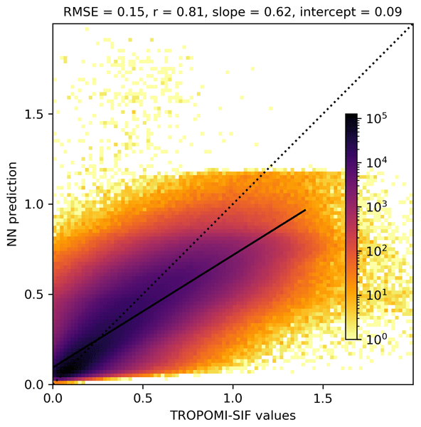
Pierre Vanderbecken, Jasmin Vural, Oscar Rojas-Muñoz, Sébastien Garrigues, Bertrand Bonan, Cédric Bacour, Uwe Rascher, Bastian Siegmann, Patricia de Rosnay, and Jean-Christophe Calvet
Biogeosciences, 23, 6687–6703, https://doi.org/10.5194/bg-23-6687-2026, https://doi.org/10.5194/bg-23-6687-2026, 2026
Short summary
Short summary
New satellite observations are used to improve our understanding of regional-scale vegetation. Innovative artificial intelligence methods are employed to combine the available information. The effectiveness of this approach is evaluated using independent observations. The results show that agricultural practices such as irrigation can be modelled more accurately.
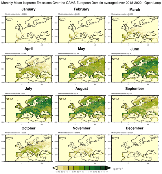
Paul D. Hamer, Miha Markelj, Oscar Rojas-Munoz, Bertrand Bonan, Jean-Christophe Calvet, Virginie Marécal, Alex Guenther, Heidi Trimmel, Islen Vallejo, Sabine Eckhardt, Gabriela Sousa Santos, Katerina Sindelarova, David Simpson, Norbert Schmidbauer, Heidi Hellén, Pascal Rubli, Stefan Reimann, Anja Claude, Dagmar Kubistin, Julie Cozic, James Dernie, and Leonor Tarrasón
Earth Syst. Sci. Data, 18, 3635–3669, https://doi.org/10.5194/essd-18-3635-2026, https://doi.org/10.5194/essd-18-3635-2026, 2026
Short summary
Short summary
Plants release gases like isoprene that can form ozone and affect air quality. Using models and satellite data, we mapped the emissions of isoprene from plants across Europe and found that droughts can reduce leaf growth, leading to lower emissions. This shows that to understand and predict air quality, we must also understand how drought impacts vegetation. Our findings highlight the value of linking extreme weather, plant health, and pollution in models of the Earth system as a whole.
Jasmin Vural, Pierre Vanderbecken, Bertrand Bonan, Oscar Rojas-Munoz, and Jean-Christophe Calvet
EGUsphere, https://doi.org/10.5194/egusphere-2026-838, https://doi.org/10.5194/egusphere-2026-838, 2026
Short summary
Short summary
New satellite observations are used to improve our understanding of agricultural land on a global scale. Innovative artificial intelligence methods are employed to combine the available information. This improvement is evaluated using independent observations and varies depending on the characteristics of instruments and models.
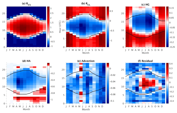
Oscar Javier Rojas Muñoz, Marjolaine Chiriaco, Sophie Bastin, and Justine Ringard
Atmos. Chem. Phys., 21, 15699–15723, https://doi.org/10.5194/acp-21-15699-2021, https://doi.org/10.5194/acp-21-15699-2021, 2021
Short summary
Short summary
A method is developed and evaluated to quantify each process that affects hourly 2 m temperature variations on a local scale, based almost exclusively on observations retrieved from an observatory near the Paris region. Each term involved in surface temperature variations is estimated, and its contribution and importance are also assessed. It is found that clouds are the main modulator on hourly temperature variations for most hours of the day, and thus their characterization is addressed.
Roberto Colombo, Béatrice Berthelot, Alireza Mahmoodi, Louis Sainte-Marie, Gwennaël Matot, Jorge Vicent Servera, Ornela Nanushi, Brice Mora, Mohamed Salah Djellali, Neus Sabater, Pekka Kolmonen, Timo H. Virtanen, Astrid M. Zimmermann, Pieter De Vis, Micol Rossini, Giulia Tagliabue, Pietro Chierichetti, Sergio Cogliati, Juliane Bendig, Bastian Siegmann, Uwe Rascher, Egor Prikaziuk, Christiaan van der Tol, Darren Ghent, Jasdeep Singh Anand, Tommaso Julitta, Matthias Drusch, Marco Celesti, Dirk Schüttemeyer, and Marin Tudoroiu
Int. Arch. Photogramm. Remote Sens. Spatial Inf. Sci., XLVIII-M-12-2026, 17–24, https://doi.org/10.5194/isprs-archives-XLVIII-M-12-2026-17-2026, https://doi.org/10.5194/isprs-archives-XLVIII-M-12-2026-17-2026, 2026
Pierre Vanderbecken, Jasmin Vural, Oscar Rojas-Muñoz, Sébastien Garrigues, Bertrand Bonan, Cédric Bacour, Uwe Rascher, Bastian Siegmann, Patricia de Rosnay, and Jean-Christophe Calvet
Biogeosciences, 23, 6687–6703, https://doi.org/10.5194/bg-23-6687-2026, https://doi.org/10.5194/bg-23-6687-2026, 2026
Short summary
Short summary
New satellite observations are used to improve our understanding of regional-scale vegetation. Innovative artificial intelligence methods are employed to combine the available information. The effectiveness of this approach is evaluated using independent observations. The results show that agricultural practices such as irrigation can be modelled more accurately.
Marlena Reil, Julia Kaltenborn, Donovan J. M. Allum, Francis Pelletier, Sebastian Roessler, Samip Shrestha, Zhibang Lv, John Truckenbrodt, Gabriele Schwaizer, Thomas Nagler, John W. Pomeroy, Christopher B. Marsh, Benoit Montpetit, Tobias Jonas, Gabriel Tseng, David Rolnick, Andreas J. Dietz, and Celia A. Baumhoer
EGUsphere, https://doi.org/10.5194/egusphere-2026-3833, https://doi.org/10.5194/egusphere-2026-3833, 2026
This preprint is open for discussion and under review for The Cryosphere (TC).
Short summary
Short summary
Many communities rely on snowmelt from the mountains for their water supply. However, monitoring snow from space is challenging because clouds and other factors can obscure satellite observations. We present SnowGalileo, an AI model that combines data from multiple satellites to produce snow maps. The model can produce accurate maps even when clouds are present and high-resolution data are missing. This helps to improve our understanding of snow conditions and their impact on water resources.
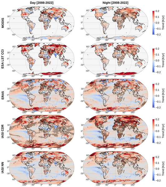
Sarah Safieddine, Selviga Sinnathamby, Juliette Hadji-Lazaro, Marie Doutriaux-Boucher, Darren Ghent, Simon Whitburn, Lieven Clarisse, and Cathy Clerbaux
Earth Obs., 1, 59–75, https://doi.org/10.5194/eo-1-59-2026, https://doi.org/10.5194/eo-1-59-2026, 2026
Short summary
Short summary
Land and sea surface temperatures, collectively called skin temperature (Tskin), are available from satellite measurements since few decades now and provide a holistic view of the Earth's climate system. Here we review 6 different datasets of Tskin to show that climate change signature is clear from the different datasets with notable exception, such as a significant cooling in India, parts of Africa and the Pacific.
Bertrand Decharme, Diane Tzanos, Lucas Hardouin, Aaron Boone, Marie Minvielle, Patrick Le Moigne, and Rémi Gaillard
Geosci. Model Dev., 19, 7239–7277, https://doi.org/10.5194/gmd-19-7239-2026, https://doi.org/10.5194/gmd-19-7239-2026, 2026
Short summary
Short summary
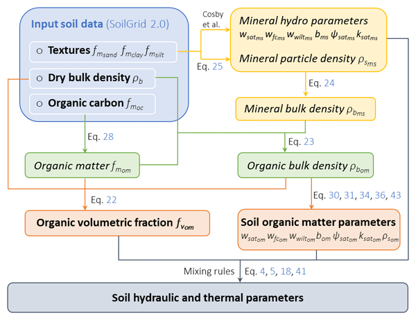
We developed a new method to represent how organic matter in soils, together with a mineral soil compactness adjustment, influences the movement of water and heat in land models. We implemented this approach in a global model and performed long-term simulations driven by weather data and global soil maps. Compared with an older empirical method, it produces more consistent soil moisture, runoff, evaporation, and ground temperature and shows closer agreement with observations.
Darrell Smith, Darren Ghent, Karen Veal, and Thomas Dowling
EGUsphere, https://doi.org/10.5194/egusphere-2026-1953, https://doi.org/10.5194/egusphere-2026-1953, 2026
This preprint is open for discussion and under review for Earth Observation (EO).
Short summary
Short summary
Traditional satellite drought monitoring becomes computationally prohibitive when scaling to larger areas and high-resolution sensors. We developed a statistical method that approximates temperature-vegetation relationships using daily summaries rather than processing millions of individual measurements. Testing in New Zealand across multiple years proved the approach maintains strong performance while significantly reducing compute, processing time and data storage requirements.
Paul D. Hamer, Miha Markelj, Oscar Rojas-Munoz, Bertrand Bonan, Jean-Christophe Calvet, Virginie Marécal, Alex Guenther, Heidi Trimmel, Islen Vallejo, Sabine Eckhardt, Gabriela Sousa Santos, Katerina Sindelarova, David Simpson, Norbert Schmidbauer, Heidi Hellén, Pascal Rubli, Stefan Reimann, Anja Claude, Dagmar Kubistin, Julie Cozic, James Dernie, and Leonor Tarrasón
Earth Syst. Sci. Data, 18, 3635–3669, https://doi.org/10.5194/essd-18-3635-2026, https://doi.org/10.5194/essd-18-3635-2026, 2026
Short summary
Short summary
Plants release gases like isoprene that can form ozone and affect air quality. Using models and satellite data, we mapped the emissions of isoprene from plants across Europe and found that droughts can reduce leaf growth, leading to lower emissions. This shows that to understand and predict air quality, we must also understand how drought impacts vegetation. Our findings highlight the value of linking extreme weather, plant health, and pollution in models of the Earth system as a whole.
Helmut Rott, Thomas Nagler, Markus Hetzenecker, Ralf Horn, Jens Fischer, and Julia Kubanek
EGUsphere, https://doi.org/10.5194/egusphere-2026-2104, https://doi.org/10.5194/egusphere-2026-2104, 2026
Short summary
Short summary
The paper reports on a field experiment in Alpine terrain addressing methods for deriving snow mass from synthetic aperture radar data. Multiple repeat-pass acquisitions spanning snowfall events of different intensity were acquired with an airborne C- and L-band radar system. Three different approaches based on the interferometric path delay in snow were applied for retrieving snow mass, confirming the performance of the method. The complementarity of different processing approaches is shown.
Yann Baehr, Pierre Vanderbecken, Bertrand Bonan, Catherine Robert, Mathieu Regimbeau, François Pimont, Kevyn Raynal, Xiangzhuo Liu, Remi Savazzi, Moncef Garouani, Josiane Mothe, Nemesio Rodriguez-Fernandez, Lionel Jarlan, and Jean-Christophe Calvet
EGUsphere, https://doi.org/10.5194/egusphere-2026-1247, https://doi.org/10.5194/egusphere-2026-1247, 2026
This preprint is open for discussion and under review for Natural Hazards and Earth System Sciences (NHESS).
Short summary
Short summary
This study produced vegetation water content maps to help manage the risk of forest fires in France. Artificial intelligence was used alongside land surface model outputs, satellite data and in situ observations to monitor vegetation stress in real time. The methodology tested has been shown to be robust and spatially consistent.
Jasmin Vural, Pierre Vanderbecken, Bertrand Bonan, Oscar Rojas-Munoz, and Jean-Christophe Calvet
EGUsphere, https://doi.org/10.5194/egusphere-2026-838, https://doi.org/10.5194/egusphere-2026-838, 2026
Short summary
Short summary
New satellite observations are used to improve our understanding of agricultural land on a global scale. Innovative artificial intelligence methods are employed to combine the available information. This improvement is evaluated using independent observations and varies depending on the characteristics of instruments and models.
Onaïa Savary, Constantin Ardilouze, and Julien Cattiaux
Weather Clim. Dynam., 7, 223–245, https://doi.org/10.5194/wcd-7-223-2026, https://doi.org/10.5194/wcd-7-223-2026, 2026
Short summary
Short summary
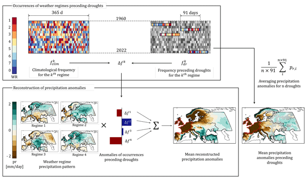
We investigate the link between European meteorological droughts and persistent year-round weather regimes derived from mid-tropospheric circulation. Using a novel regionalization based on drought synchronicity and reanalysis data, we show that regime frequency anomalies partly explain drought occurrence, especially in western Europe and in winter, highlighting both the potential and limits of regime-based drought prediction.
Bethan L. Harris, Christopher M. Taylor, Wouter Dorigo, Ruxandra-Maria Zotta, Darren Ghent, and Iván Noguera
Hydrol. Earth Syst. Sci., 29, 6917–6933, https://doi.org/10.5194/hess-29-6917-2025, https://doi.org/10.5194/hess-29-6917-2025, 2025
Short summary
Short summary
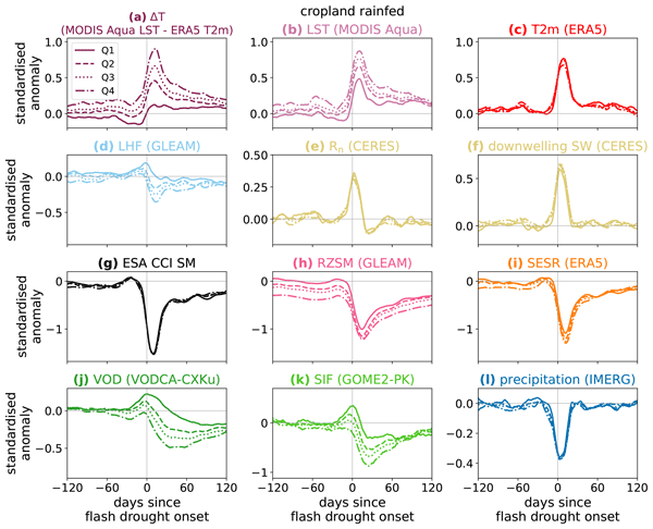
An improved understanding of land-atmosphere coupling processes during flash (rapid-onset) droughts is needed to aid the development of forecasts for these events. We use satellite observations to investigate the surface energy budget during flash droughts globally. The most intense events show a perturbed surface energy budget months before onset. In some regions, vegetation observations 1–2 months before onset provide information on the likelihood of heat extremes during an event.
Gabriel Fernando Narváez-Campo and Constantin Ardilouze
Hydrol. Earth Syst. Sci., 29, 4739–4759, https://doi.org/10.5194/hess-29-4739-2025, https://doi.org/10.5194/hess-29-4739-2025, 2025
Short summary
Short summary
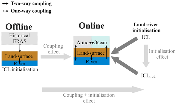
We demonstrate the capability of a global operational system to predict seasonal river discharges by accounting for interactions between the atmosphere, ocean, land and rivers. The fully coupled approach introduces a convenient single-step workflow, allowing the simultaneous production of atmospheric and streamflow forecasts. Overall, the approach outperforms the classical ensemble streamflow prediction approach, providing insight into the next-generation hydrological forecasting systems.
Aurélien Mirebeau, Cécile de Munck, Bertrand Bonan, Christine Delire, Aude Lemonsu, Valéry Masson, and Stephan Weber
Geosci. Model Dev., 18, 5329–5349, https://doi.org/10.5194/gmd-18-5329-2025, https://doi.org/10.5194/gmd-18-5329-2025, 2025
Short summary
Short summary
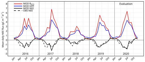
The greening of cities is recommended to limit the effects of climate change. In particular, green roofs can provide numerous environmental benefits, such as urban cooling, water retention, and carbon sequestration. The aim of this research is to develop a new module for calculating green roof CO2 fluxes within a model that can already simulate hydrological and thermal processes of such roofs. The calibration and evaluation of this module take advantage of long-term experimental data.
Anna Puggaard, Nicolaj Hansen, Ruth Mottram, Thomas Nagler, Stefan Scheiblauer, Sebastian B. Simonsen, Louise S. Sørensen, Jan Wuite, and Anne M. Solgaard
The Cryosphere, 19, 2963–2981, https://doi.org/10.5194/tc-19-2963-2025, https://doi.org/10.5194/tc-19-2963-2025, 2025
Short summary
Short summary
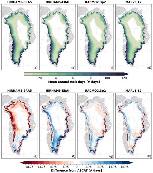
Regional climate models are currently the only source for assessing the melt volume of the Greenland Ice Sheet on a global scale. This study compares the modeled melt volume with observations from weather stations and melt extent observed from the Advanced SCATterometer (ASCAT) to assess the performance of the models. It highlights the importance of critically evaluating model outputs with high-quality satellite measurements to improve the understanding of variability among models.
Sophie Barthelemy, Bertrand Bonan, Miquel Tomas-Burguera, Gilles Grandjean, Séverine Bernardie, Jean-Philippe Naulin, Patrick Le Moigne, Aaron Boone, and Jean-Christophe Calvet
Hydrol. Earth Syst. Sci., 29, 2321–2337, https://doi.org/10.5194/hess-29-2321-2025, https://doi.org/10.5194/hess-29-2321-2025, 2025
Short summary
Short summary
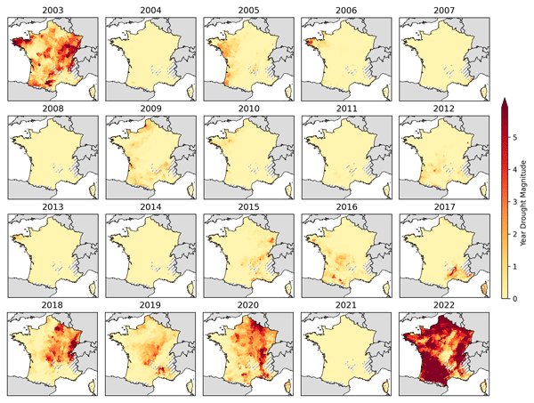
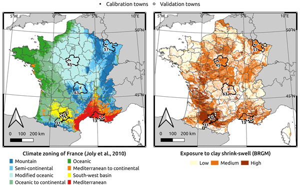
A drought index is developed that quantifies drought on an annual scale, making it applicable to monitoring clay shrinkage damage to buildings. A comparison with the number of insurance claims for subsidence shows that the presence of trees near individual houses must be taken into account. Significant soil moisture droughts occurred in France in 2003, 2018, 2019, 2020, and 2022. Particularly high index values are observed in 2022. It is found that droughts will become more severe in the future.
Annett Bartsch, Xaver Muri, Markus Hetzenecker, Kimmo Rautiainen, Helena Bergstedt, Jan Wuite, Thomas Nagler, and Dmitry Nicolsky
The Cryosphere, 19, 459–483, https://doi.org/10.5194/tc-19-459-2025, https://doi.org/10.5194/tc-19-459-2025, 2025
Short summary
Short summary
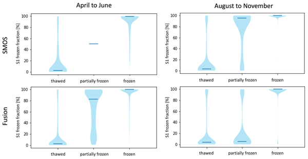
We developed a robust freeze–thaw detection approach, applying a constant threshold to Copernicus Sentinel-1 data that is suitable for tundra regions. All global, coarser-resolution products, tested with the resulting benchmarking dataset, are of value for freeze–thaw retrieval, although differences were found depending on the seasons, particularly during the spring and autumn transition.
Richard Parsons, Sainan Sun, G. Hilmar Gudmundsson, Jan Wuite, and Thomas Nagler
The Cryosphere, 18, 5789–5801, https://doi.org/10.5194/tc-18-5789-2024, https://doi.org/10.5194/tc-18-5789-2024, 2024
Short summary
Short summary
In 2022, multi-year landfast sea ice in Antarctica's Larsen B embayment disintegrated, after which time an increase in the rate at which Crane Glacier discharged ice into the ocean was observed. As the fast ice was joined to the glacier terminus, it could provide resistance against the glacier's flow, slowing down the rate of ice discharge. We used numerical modelling to quantify this resistive stress and found that the fast ice provided significant support to Crane prior to its disintegration.
En Liu, Yonghua Zhu, Jean-Christophe Calvet, Haishen Lü, Bertrand Bonan, Jingyao Zheng, Qiqi Gou, Xiaoyi Wang, Zhenzhou Ding, Haiting Xu, Ying Pan, and Tingxing Chen
Hydrol. Earth Syst. Sci., 28, 2375–2400, https://doi.org/10.5194/hess-28-2375-2024, https://doi.org/10.5194/hess-28-2375-2024, 2024
Short summary
Short summary
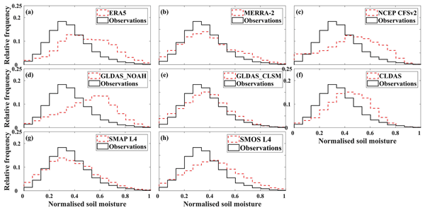
Overestimated root zone soil moisture (RZSM) based on land surface models (LSMs) is attributed to overestimated precipitation and an underestimated ratio of transpiration to total evapotranspiration and performs better in the wet season. Underestimated SMOS L3 surface SM triggers the underestimated SMOS L4 RZSM, which performs better in the dry season due to the attenuated radiation in the wet season. LSMs should reduce and increase the frequency of wet and dry soil moisture, respectively.
Sophie Barthelemy, Bertrand Bonan, Jean-Christophe Calvet, Gilles Grandjean, David Moncoulon, Dorothée Kapsambelis, and Séverine Bernardie
Nat. Hazards Earth Syst. Sci., 24, 999–1016, https://doi.org/10.5194/nhess-24-999-2024, https://doi.org/10.5194/nhess-24-999-2024, 2024
Short summary
Short summary
This work presents a drought index specifically adapted to subsidence, a seasonal phenomenon of soil shrinkage that occurs frequently in France and damages buildings. The index is computed from land surface model simulations and evaluated by a rank correlation test with insurance data. With its optimal configuration, the index is able to identify years of both zero and significant loss.
Dominik Rains, Isabel Trigo, Emanuel Dutra, Sofia Ermida, Darren Ghent, Petra Hulsman, Jose Gómez-Dans, and Diego G. Miralles
Earth Syst. Sci. Data, 16, 567–593, https://doi.org/10.5194/essd-16-567-2024, https://doi.org/10.5194/essd-16-567-2024, 2024
Short summary
Short summary
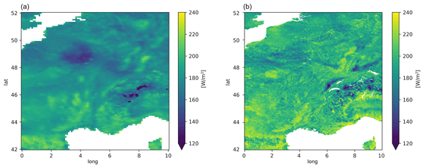
Land surface temperature and surface net radiation are vital inputs for many land surface and hydrological models. However, current remote sensing datasets of these variables come mostly at coarse resolutions, and the few high-resolution datasets available have large gaps due to cloud cover. Here, we present a continuous daily product for both variables across Europe for 2018–2019 obtained by combining observations from geostationary as well as polar-orbiting satellites.
Kandice L. Harper, Céline Lamarche, Andrew Hartley, Philippe Peylin, Catherine Ottlé, Vladislav Bastrikov, Rodrigo San Martín, Sylvia I. Bohnenstengel, Grit Kirches, Martin Boettcher, Roman Shevchuk, Carsten Brockmann, and Pierre Defourny
Earth Syst. Sci. Data, 15, 1465–1499, https://doi.org/10.5194/essd-15-1465-2023, https://doi.org/10.5194/essd-15-1465-2023, 2023
Short summary
Short summary
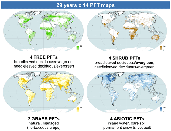
We built a spatially explicit annual plant-functional-type (PFT) dataset for 1992–2020 exhibiting intra-class spatial variability in PFT fractional cover at 300 m. For each year, 14 maps of percentage cover are produced: bare soil, water, permanent snow/ice, built, managed grasses, natural grasses, and trees and shrubs, each split into leaf type and seasonality. Model simulations indicate significant differences in simulated carbon, water, and energy fluxes in some regions using this new set.
En Liu, Yonghua Zhu, Jean-christophe Calvet, Haishen Lü, Bertrand Bonan, Jingyao Zheng, Qiqi Gou, Xiaoyi Wang, Zhenzhou Ding, Haiting Xu, Ying Pan, and Tingxing Chen
Hydrol. Earth Syst. Sci. Discuss., https://doi.org/10.5194/hess-2023-33, https://doi.org/10.5194/hess-2023-33, 2023
Manuscript not accepted for further review
Short summary
Short summary
Among the 8 considered products, GLDAS_CLSM product performs best. All RZSM products overestimate the in situ measurements which attributes to a wet bias of air temperature, precipitation amount and frequency except the underestimation of SMOS L4 RZSM related to the underestimation of SMOS L3 SSM. The higher R between SMPA L4 and MERRA-2 was attributed to they both use CLSM and meteorological forcing from GEOS-5 where precipitation was corrected with CPCU precipitation product.
Arsène Druel, Simon Munier, Anthony Mucia, Clément Albergel, and Jean-Christophe Calvet
Geosci. Model Dev., 15, 8453–8471, https://doi.org/10.5194/gmd-15-8453-2022, https://doi.org/10.5194/gmd-15-8453-2022, 2022
Short summary
Short summary
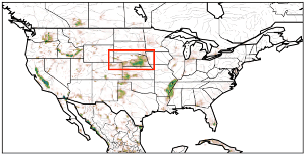
Crop phenology and irrigation is implemented into a land surface model able to work at a global scale. A case study is presented over Nebraska (USA). Simulations with and without the new scheme are compared to different satellite-based observations. The model is able to produce a realistic yearly irrigation water amount. The irrigation scheme improves the simulated leaf area index, gross primary productivity, evapotransipiration, and land surface temperature.
Karla Boxall, Frazer D. W. Christie, Ian C. Willis, Jan Wuite, and Thomas Nagler
The Cryosphere, 16, 3907–3932, https://doi.org/10.5194/tc-16-3907-2022, https://doi.org/10.5194/tc-16-3907-2022, 2022
Short summary
Short summary
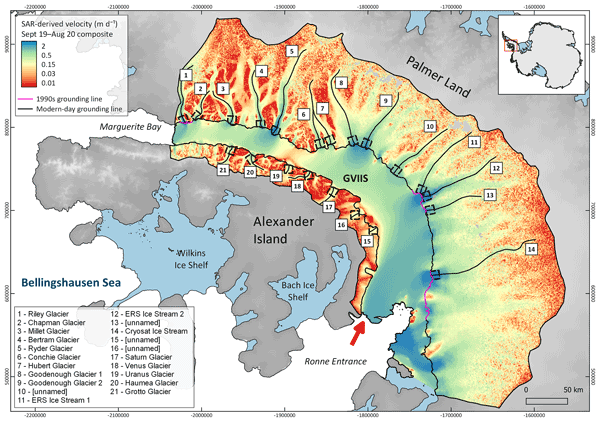
Using high-spatial- and high-temporal-resolution satellite imagery, we provide the first evidence for seasonal flow variability of land ice draining to George VI Ice Shelf (GVIIS), Antarctica. Ultimately, our findings imply that other glaciers in Antarctica may be susceptible to – and/or currently undergoing – similar ice-flow seasonality, including at the highly vulnerable and rapidly retreating Pine Island and Thwaites glaciers.
Ioanna Karagali, Magnus Barfod Suhr, Ruth Mottram, Pia Nielsen-Englyst, Gorm Dybkjær, Darren Ghent, and Jacob L. Høyer
The Cryosphere, 16, 3703–3721, https://doi.org/10.5194/tc-16-3703-2022, https://doi.org/10.5194/tc-16-3703-2022, 2022
Short summary
Short summary
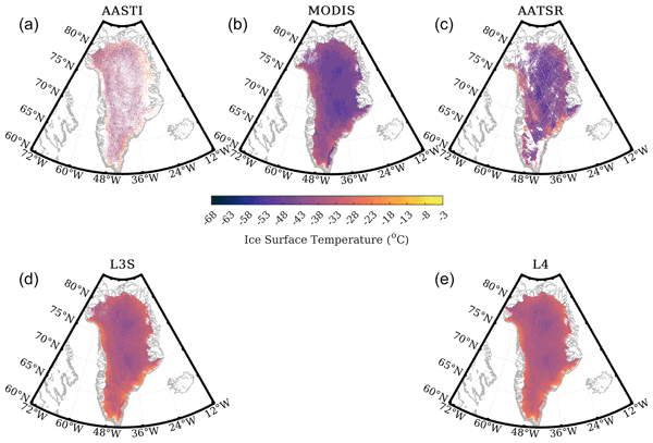
Ice surface temperature (IST) products were used to develop the first multi-sensor, gap-free Level 4 (L4) IST product of the Greenland Ice Sheet (GIS) for 2012, when a significant melt event occurred. For the melt season, mean IST was −15 to −1 °C, and almost the entire GIS experienced at least 1 to 5 melt days. Inclusion of the L4 IST to a surface mass budget (SMB) model improved simulated surface temperatures during the key onset of the melt season, where biases are typically large.
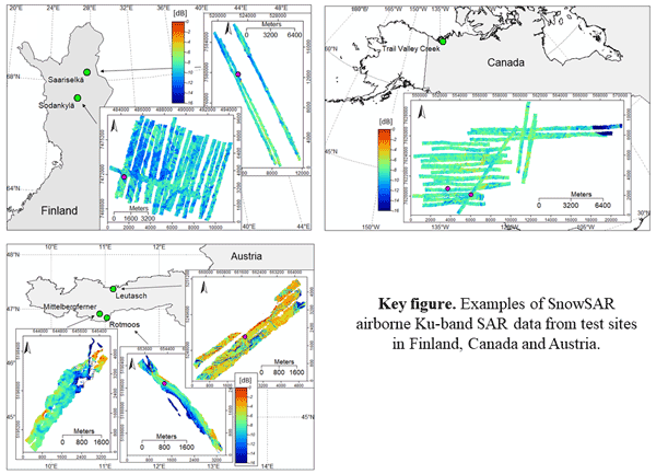
Juha Lemmetyinen, Juval Cohen, Anna Kontu, Juho Vehviläinen, Henna-Reetta Hannula, Ioanna Merkouriadi, Stefan Scheiblauer, Helmut Rott, Thomas Nagler, Elisabeth Ripper, Kelly Elder, Hans-Peter Marshall, Reinhard Fromm, Marc Adams, Chris Derksen, Joshua King, Adriano Meta, Alex Coccia, Nick Rutter, Melody Sandells, Giovanni Macelloni, Emanuele Santi, Marion Leduc-Leballeur, Richard Essery, Cecile Menard, and Michael Kern
Earth Syst. Sci. Data, 14, 3915–3945, https://doi.org/10.5194/essd-14-3915-2022, https://doi.org/10.5194/essd-14-3915-2022, 2022
Short summary
Short summary
The manuscript describes airborne, dual-polarised X and Ku band synthetic aperture radar (SAR) data collected over several campaigns over snow-covered terrain in Finland, Austria and Canada. Colocated snow and meteorological observations are also presented. The data are meant for science users interested in investigating X/Ku band radar signatures from natural environments in winter conditions.

Frank Paul, Livia Piermattei, Désirée Treichler, Lin Gilbert, Luc Girod, Andreas Kääb, Ludivine Libert, Thomas Nagler, Tazio Strozzi, and Jan Wuite
The Cryosphere, 16, 2505–2526, https://doi.org/10.5194/tc-16-2505-2022, https://doi.org/10.5194/tc-16-2505-2022, 2022
Short summary
Short summary
Glacier surges are widespread in the Karakoram and have been intensely studied using satellite data and DEMs. We use time series of such datasets to study three glacier surges in the same region of the Karakoram. We found strongly contrasting advance rates and flow velocities, maximum velocities of 30 m d−1, and a change in the surge mechanism during a surge. A sensor comparison revealed good agreement, but steep terrain and the two smaller glaciers caused limitations for some of them.
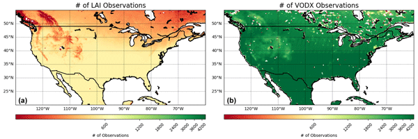
Anthony Mucia, Bertrand Bonan, Clément Albergel, Yongjun Zheng, and Jean-Christophe Calvet
Biogeosciences, 19, 2557–2581, https://doi.org/10.5194/bg-19-2557-2022, https://doi.org/10.5194/bg-19-2557-2022, 2022
Short summary
Short summary
For the first time, microwave vegetation optical depth data are assimilated in a land surface model in order to analyze leaf area index and root zone soil moisture. The advantage of microwave products is the higher observation frequency. A large variety of independent datasets are used to verify the added value of the assimilation. It is shown that the assimilation is able to improve the representation of soil moisture, vegetation conditions, and terrestrial water and carbon fluxes.
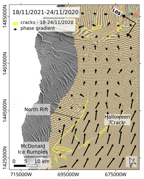
Ludivine Libert, Jan Wuite, and Thomas Nagler
The Cryosphere, 16, 1523–1542, https://doi.org/10.5194/tc-16-1523-2022, https://doi.org/10.5194/tc-16-1523-2022, 2022
Short summary
Short summary
Open fractures are important to monitor because they weaken the ice shelf structure. We propose a novel approach using synthetic aperture radar (SAR) interferometry for automatic delineation of ice shelf cracks. The method is applied to Sentinel-1 images of Brunt Ice Shelf, Antarctica, and the propagation of the North Rift, which led to iceberg calving in February 2021, is traced. It is also shown that SAR interferometry is more sensitive to rifting than SAR backscatter and optical imagery.
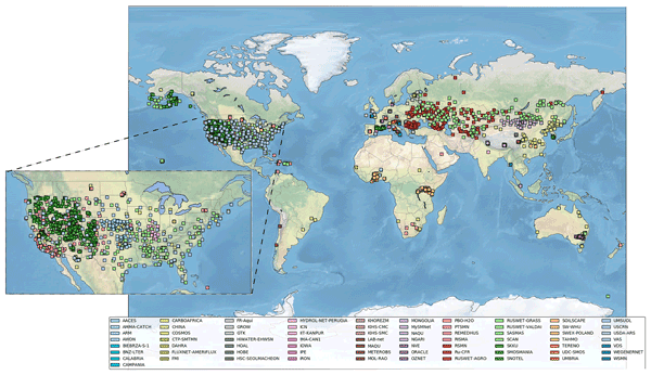
Wouter Dorigo, Irene Himmelbauer, Daniel Aberer, Lukas Schremmer, Ivana Petrakovic, Luca Zappa, Wolfgang Preimesberger, Angelika Xaver, Frank Annor, Jonas Ardö, Dennis Baldocchi, Marco Bitelli, Günter Blöschl, Heye Bogena, Luca Brocca, Jean-Christophe Calvet, J. Julio Camarero, Giorgio Capello, Minha Choi, Michael C. Cosh, Nick van de Giesen, Istvan Hajdu, Jaakko Ikonen, Karsten H. Jensen, Kasturi Devi Kanniah, Ileen de Kat, Gottfried Kirchengast, Pankaj Kumar Rai, Jenni Kyrouac, Kristine Larson, Suxia Liu, Alexander Loew, Mahta Moghaddam, José Martínez Fernández, Cristian Mattar Bader, Renato Morbidelli, Jan P. Musial, Elise Osenga, Michael A. Palecki, Thierry Pellarin, George P. Petropoulos, Isabella Pfeil, Jarrett Powers, Alan Robock, Christoph Rüdiger, Udo Rummel, Michael Strobel, Zhongbo Su, Ryan Sullivan, Torbern Tagesson, Andrej Varlagin, Mariette Vreugdenhil, Jeffrey Walker, Jun Wen, Fred Wenger, Jean Pierre Wigneron, Mel Woods, Kun Yang, Yijian Zeng, Xiang Zhang, Marek Zreda, Stephan Dietrich, Alexander Gruber, Peter van Oevelen, Wolfgang Wagner, Klaus Scipal, Matthias Drusch, and Roberto Sabia
Hydrol. Earth Syst. Sci., 25, 5749–5804, https://doi.org/10.5194/hess-25-5749-2021, https://doi.org/10.5194/hess-25-5749-2021, 2021
Short summary
Short summary
The International Soil Moisture Network (ISMN) is a community-based open-access data portal for soil water measurements taken at the ground and is accessible at https://ismn.earth. Over 1000 scientific publications and thousands of users have made use of the ISMN. The scope of this paper is to inform readers about the data and functionality of the ISMN and to provide a review of the scientific progress facilitated through the ISMN with the scope to shape future research and operations.
Constantin Ardilouze, Damien Specq, Lauriane Batté, and Christophe Cassou
Weather Clim. Dynam., 2, 1033–1049, https://doi.org/10.5194/wcd-2-1033-2021, https://doi.org/10.5194/wcd-2-1033-2021, 2021
Short summary
Short summary
Forecasting temperature patterns beyond 2 weeks is very challenging, although occasionally, forecasts show more skill over Europe. Our study indicates that the level of skill varies concurrently for two distinct forecast systems. It also shows that higher skill occurs when forecasts are issued during specific patterns of atmospheric circulation that tend to be particularly persistent.
These results could help forecasters estimate a priori how trustworthy extended-range forecasts will be.
Oscar Javier Rojas Muñoz, Marjolaine Chiriaco, Sophie Bastin, and Justine Ringard
Atmos. Chem. Phys., 21, 15699–15723, https://doi.org/10.5194/acp-21-15699-2021, https://doi.org/10.5194/acp-21-15699-2021, 2021
Short summary
Short summary
A method is developed and evaluated to quantify each process that affects hourly 2 m temperature variations on a local scale, based almost exclusively on observations retrieved from an observatory near the Paris region. Each term involved in surface temperature variations is estimated, and its contribution and importance are also assessed. It is found that clouds are the main modulator on hourly temperature variations for most hours of the day, and thus their characterization is addressed.
Cited articles
Barella, R., Mortimer, C., Marin, C., Schwaizer, G., Mölg, N., Nagler, T., Wunderle, S., Xiao, X., Luojus, K., Venäläinen, P., Takala, M., Pulliainen, J., Lemmetyinen, J., Moisander, M., and Solberg R.: ESA CCI+ Snow ECV: Product User Guide, version 4.0, April 2024, http://snow-cci.enveo.at/documents/Snow_cci_D4.3_PUG_v4.0.pdf (last access: July 2026), 2024.
Barella-Ortiz, A., Quintana-Seguí, P., Dari, J., Brocca, L., Altés, V., Villar, J. M., Paolini, G., Escorihuela, M. J., Bonan, B., Calvet, J.-C., and Tzanos, D.: Improved SAFRAN forcing and ECOCLIMAP-SG datasets to simulate irrigation over the Ebro basin, EGU General Assembly 2022, Vienna, Austria, 23–27 May 2022, EGU22-7834, https://doi.org/10.5194/egusphere-egu22-7834, 2022.
Bélair, S., Crevier, L.-P., Mailhot, J., Bilodeau, B., and Delage, Y.: Operational Implementation of the ISBA Land Surface Scheme in the Canadian Regional Weather Forecast Model. Part I: Warm Season Results, J. Hydrometeorol., 4, 352–370, https://doi.org/10.1175/1525-7541(2003)4<352:OIOTIL>2.0.CO;2, 2003a.
Bélair, S., Brown, R., Mailhot, J., Bilodeau, B., and Crevier, L.-P.: Operational Implementation of the ISBA Land Surface Scheme in the Canadian Regional Weather Forecast Model. Part II: Cold Season Results, J. Hydrometeorol., 4, 371–386, https://doi.org/10.1175/1525-7541(2003)4<371:OIOTIL>2.0.CO;2, 2003b.
Blyth, E. M., Arora, V. K., Clark, D. B., Dadson, S. J., De Kauwe, M. G., Lawrence, D. M., Melton, J. R., Pongratz, J., Turton, R. H., Yoshimura, K., and Yuan, H.: Advances in Land Surface Modelling, Curr. Clim. Change Rep., 7, 45–71, https://doi.org/10.1007/s40641-021-00171-5, 2021.
Boone, A. and Etchevers, P.: An Intercomparison of Three Snow Schemes of Varying Complexity Coupled to the Same Land Surface Model: Local-Scale Evaluation at an Alpine Site, J. Hydrometeorol., 2, 374–394, https://doi.org/10.1175/1525-7541(2001)002<0374:AIOTSS>2.0.CO;2, 2001.
Boone, A., Masson, V., Meyers, T., and Noilhan, J.: The Influence of the Inclusion of Soil Freezing on Simulations by a Soil–Vegetation–Atmosphere Transfer Scheme, J. Appl. Meteor., 39, 1544–1569, https://doi.org/10.1175/1520-0450(2000)039<1544:TIOTIO>2.0.CO;2, 2000.
Bounoua, L., DeFries, R., Collatz, G. J., Sellers, P., and Khan, H.: Effects of Land Cover Conversion on Surface Climate, Climatic Change, 52, 29–64, https://doi.org/10.1023/A:1013051420309, 2002.
Brown, R., de Rosnay, P., Robinson, D., and Luojus, K.: Snow Assessments: Northern Hemisphere 2019–2020 Winter Snow Cover, WMO Global Cryosphere Watch, https://globalcryospherewatch.org/snow-assessments-2020 (last access: July 2026), 2020.
Calvet, J.-C. and Champeaux, J.-L.: L'apport de la télédétection spatiale à la modélisation des surfaces continentales, La Météorologie, 108, 52–58, https://doi.org/10.37053/lameteorologie-2020-0016, 2020.
Calvet, J.-C., Noilhan, J., Roujean, J.-L., Bessemoulin, P., Cabelguenne, M., Olioso, A., and Wigneron, J.-P.: An interactive vegetation SVAT model tested against data from six contrasting sites, Agr. Forest Meteorol., 92, 73–95, https://doi.org/10.1016/S0168-1923(98)00091-4, 1998.
Calvet, J.-C., Gibelin, A.-L., Roujean, J.-L., Martin, E., Le Moigne, P., Douville, H., and Noilhan, J.: Past and future scenarios of the effect of carbon dioxide on plant growth and transpiration for three vegetation types of southwestern France, Atmos. Chem. Phys., 8, 397–406, https://doi.org/10.5194/acp-8-397-2008, 2008.
Chiu, J., Paredes-Mesa, S., Lakhankar, T., Romanov, P., Krakauer, N., Khanbilvardi, R., and Ferraro, R.: Intercomparison and Validation of MIRS, MSPPS, and IMS Snow Cover Products, Adv. Meteorol., 2020, 4532478, https://doi.org/10.1155/2020/4532478, 2020.
CNRM: SURFEX code, CNRM, https://www.umr-cnrm.fr/surfex/data/OPEN-SURFEX/open_surfex_v9_0_0_20231024.tar.gz (last access: July 2026), 2023.
Crow, W. T., Kumar, S. V., and Bolten, J. D.: On the utility of land surface models for agricultural drought monitoring, Hydrol. Earth Syst. Sci., 16, 3451–3460, https://doi.org/10.5194/hess-16-3451-2012, 2012.
de Jeu, R. A. M., Wagner, W., Holmes, T. R. H., Dolman, A. J., van de Giesen, N. C., and Friesen, J.: Global Soil Moisture Patterns Observed by Space Borne Microwave Radiometers and Scatterometers, Surv. Geophys., 29, 399–420, https://doi.org/10.1007/s10712-008-9044-0, 2008.
Decharme, B., Brun, E., Boone, A., Delire, C., Le Moigne, P., and Morin, S.: Impacts of snow and organic soils parameterization on northern Eurasian soil temperature profiles simulated by the ISBA land surface model, The Cryosphere, 10, 853–877, https://doi.org/10.5194/tc-10-853-2016, 2016.
Decharme, B., Delire, C., Minvielle, M., Colin, J., Vergnes, J.-P., Alias, A., Saint-Martin, D., Séférian, R., Sénési, S., and Voldoire, A.: Recent changes in the ISBA‐CTRIP land surface system for use in the CNRM‐CM6 climate model and in global off‐line hydrological applications, J. Adv. Model. Earth Sy., 11, 1207–1252, https://doi.org/10.1029/2018MS001545, 2019.
Delire, C., Séférian, R., Decharme, B., Alkama, R., Calvet, J.-C., Carrer, D., Gibelin, A.-L., Joetzjer, E., Morel, X., Rocher, M., and Tzanos, D.: The global land carbon cycle simulated with ISBA-CTRIP: impro-vements over the last decade, J. Adv. Model. Earth Sy., 12, e2019MS001886, https://doi.org/10.1029/2019MS001886, 2020.
Deschamps-Berger, C., López-Moreno, J. I., Gascoin, S., Mazzotti, G., and Boone, A.: Where snow and forest meet: A global atlas, Geophys. Res. Lett., 52, e2024GL113684, https://doi.org/10.1029/2024GL113684, 2025.
Druel, A., Munier, S., Mucia, A., Albergel, C., and Calvet, J.-C.: Implementation of a new crop phenology and irrigation scheme in the ISBA land surface model using SURFEX_v8.1, Geosci. Model Dev., 15, 8453–8471, https://doi.org/10.5194/gmd-15-8453-2022, 2022.
Etchanchu, J., Rivalland, V., Gascoin, S., Cros, J., Tallec, T., Brut, A., and Boulet, G.: Effects of high spatial and temporal resolution Earth observations on simulated hydrometeorological variables in a cropland (southwestern France), Hydrol. Earth Syst. Sci., 21, 5693–5708, https://doi.org/10.5194/hess-21-5693-2017, 2017.
Faroux, S., Kaptué Tchuenté, A. T., Roujean, J.-L., Masson, V., Martin, E., and Le Moigne, P.: ECOCLIMAP-II/Europe: a twofold database of ecosystems and surface parameters at 1 km resolution based on satellite information for use in land surface, meteorological and climate models, Geosci. Model Dev., 6, 563–582, https://doi.org/10.5194/gmd-6-563-2013, 2013.
Gao, C., Jiang, X., Qian, Y., Qiu, S., Ma, L., and Li, Z.: A neural network based method for land surface temperature retrieval from AMSR-E passive microwave data, in: 2013 IEEE International Geoscience and Remote Sensing Symposium–IGARSS, 469–472, https://doi.org/10.1109/IGARSS.2013.6721194, 2013.
Ghent, D. J., Veal, K., and Perry, M.: ESA Land Surface Temperature Climate Change Initiative (LST_cci): Daily land surface temperature from MODIS (Moderate resolution Infra-red Spectroradiometer) on Terra, level 3 collated (L3C) global product (2000–2021), version 4.00, NERC EDS Centre for Environmental Data Analysis [data set], https://doi.org/10.5285/d56a6215ce394ddd8dff6bea5dbb0780, 2025.
Giard, D. and Bazile, E.: Implementation of a New Assimilation Scheme for Soil and Surface Variables in a Global NWP Model, Mon. Weather Rev., 128. 997–1015, https://doi.org/10.1175/1520-0493(2000)128<0997:IOANAS>2.0.CO;2, 2000.
Hersbach, H., Bell, B., Berrisford, P., Hirahara, S., Horányi, A., Muñoz-Sabater, J., Nicolas, J., Peubey, C., Radu, R., Schepers, D., Simmons, A., Soci, C., Abdalla, S., Abellan, X., Balsamo, G., Bechtold, P., Biavati, G., Bidlot, J., Bonavita, M., De Chiara, G., Dahlgren, P., Dee, D., Diamantakis, M., Dragani, R., Flemming, J., Forbes, R., Fuentes, M., Geer, A., Haimberger, L., Healy, S., Hogan, R. J., Hólm, E., Janisková, M., Keeley, S., Laloyaux, P., Lopez, P., Lupu, C., Radnoti, G., de Rosnay, P., Rozum, I., Vamborg, F., Villaume, S., and Thépaut, J.-N.: The ERA5 global reanalysis, Q. J. Roy. Meteor. Soc., 146, 1999–2049, https://doi.org/10.1002/qj.3803, 2020.
Jose, V., Chandrasekar, A., and Reddy Rodda, S.: Impact of Historical Land Cover Changes on Land Surface Characteristics over the Indian Region Using Land Information System, Pure Appl. Geophys., 181, 2561–2588, https://doi.org/10.1007/s00024-024-03523-y, 2024.
Kaptue, A., Roujean, J.-L., and Faroux, S.: ECOCLIMAP-II programme: A new land cover classification at 1 km from MODIS and vegetation data time series over the western Africa in the frame of AMMA project, in: 2009 IEEE International Geoscience and Remote Sensing Symposium, IV–1023–IV–1026, https://doi.org/10.1109/IGARSS.2009.5417555, 2009.
Kouki, K., Luojus, K., and Riihelä, A.: Evaluation of snow cover properties in ERA5 and ERA5-Land with several satellite-based datasets in the Northern Hemisphere in spring 1982–2018, The Cryosphere, 17, 5007–5026, https://doi.org/10.5194/tc-17-5007-2023, 2023.
Lawrence, P. J. and Chase, T. N.: Representing a new MODIS consistent land surface in the Community Land Model (CLM 3.0), J. Geophysical Res.-Biogeo., 112, G01023, https://doi.org/10.1029/2006JG000168, 2007.
Levis, S.: Modeling vegetation and land use in models of the Earth System, WIREs Clim. Change, 1, 840–856, https://doi.org/10.1002/wcc.83, 2010.
Li, W., MacBean, N., Ciais, P., Defourny, P., Lamarche, C., Bontemps, S., Houghton, R. A., and Peng, S.: Gross and net land cover changes in the main plant functional types derived from the annual ESA CCI land cover maps (1992–2015), Earth Syst. Sci. Data, 10, 219–234, https://doi.org/10.5194/essd-10-219-2018, 2018.
Ling, X., Huang, Y., Guo, W., Wang, Y., Chen, C., Qiu, B., Ge, J., Qin, K., Xue, Y., and Peng, J.: Comprehensive evaluation of satellite-based and reanalysis soil moisture products using in situ observations over China, Hydrol. Earth Syst. Sci., 25, 4209–4229, https://doi.org/10.5194/hess-25-4209-2021, 2021.
Liu, E., Zhu, Y., Lü, H., Bonan, B., Munier, S., and Calvet, J.-C.: Impact of leaf area index assimilation and gauge-corrected precipitation on land surface variables in LDAS-Monde: a case study over China, J. Hydrol., 133304, https://doi.org/10.1016/j.jhydrol.2025.133304, 2025.
Liu, S., Liu, X., Yu, L., Wang, Y., Zhang, G. J., Gong, P., Huang, W., Wang, B., Yang, M., and Cheng, Y.: Climate response to introduction of the ESA CCI land cover data to the NCAR CESM, Clim. Dynam., 56, 4109–4127, https://doi.org/10.1007/s00382-021-05690-3, 2021.
Luojus, K., Pulliainen, J., Takala, M., Lemmetyinen, J., Mortimer, C., Derksen, C., Mudryk, L., Moisander, M., Hiltunen, M., Smolander, T., Ikonen, J., Cohen, J., Salminen, M., Norberg, J., Veijola, K., and Venäläinen, P.: GlobSnow v3.0 Northern Hemisphere snow water equivalent dataset, Sci. Data, 8, 163, https://doi.org/10.1038/s41597-021-00939-2, 2021.
Luojus, K., Venäläinen, P., Moisander, M., Pulliainen, J., Takala, M., Lemmetyinen, J., Derksen, C., Mortimer, C., Mudryk, L., Schwaizer, G., and Nagler, T.: ESA Snow Climate Change Initiative (Snow_cci): Snow Water Equivalent (SWE) level 3C daily global climate research data package (CRDP) (1979–2022), version 3.1 [data set], https://dx.doi.org/10.5285/9d9b, 2024.
Maas, A. E., Rottensteiner, F., Alobeid, A., and Heipke, C.: Multitemporal Classification Under Label Noise Based on Outdated Maps, Photogramm. Eng. Rem. S., 84, 263–277, https://doi.org/10.14358/PERS.84.5.263, 2018.
Masson, V., Le Moigne, P., Martin, E., Faroux, S., Alias, A., Alkama, R., Belamari, S., Barbu, A., Boone, A., Bouyssel, F., Brousseau, P., Brun, E., Calvet, J.-C., Carrer, D., Decharme, B., Delire, C., Donier, S., Essaouini, K., Gibelin, A.-L., Giordani, H., Habets, F., Jidane, M., Kerdraon, G., Kourzeneva, E., Lafaysse, M., Lafont, S., Lebeaupin Brossier, C., Lemonsu, A., Mahfouf, J.-F., Marguinaud, P., Mokhtari, M., Morin, S., Pigeon, G., Salgado, R., Seity, Y., Taillefer, F., Tanguy, G., Tulet, P., Vincendon, B., Vionnet, V., and Voldoire, A.: The SURFEXv7.2 land and ocean surface platform for coupled or offline simulation of earth surface variables and fluxes, Geosci. Model Dev., 6, 929–960, https://doi.org/10.5194/gmd-6-929-2013, 2013.
Mishra, A. K., Dinesh, A. S., Kumari, A., and Pandey, L. K.: Precipitation Extremes over India in a Coupled Land–Atmosphere Regional Climate Model: Influence of the Land Surface Model and Domain Extent, Atmosphere, 15, 44, https://doi.org/10.3390/atmos15010044, 2024.
Muñoz-Sabater, J., Dutra, E., Agustí-Panareda, A., Albergel, C., Arduini, G., Balsamo, G., Boussetta, S., Choulga, M., Harrigan, S., Hersbach, H., Martens, B., Miralles, D. G., Piles, M., Rodríguez-Fernández, N. J., Zsoter, E., Buontempo, C., and Thépaut, J.-N.: ERA5-Land: a state-of-the-art global reanalysis dataset for land applications, Earth Syst. Sci. Data, 13, 4349–4383, https://doi.org/10.5194/essd-13-4349-2021, 2021.
Orsolini, Y., Wegmann, M., Dutra, E., Liu, B., Balsamo, G., Yang, K., de Rosnay, P., Zhu, C., Wang, W., Senan, R., and Arduini, G.: Evaluation of snow depth and snow cover over the Tibetan Plateau in global reanalyses using in situ and satellite remote sensing observations, The Cryosphere, 13, 2221–2239, https://doi.org/10.5194/tc-13-2221-2019, 2019.
Pérez-Planells, L., Ghent, D., Ermida, S., Martin, M., and Göttsche, F.-M.: Retrieval Consistency between LST CCI Satellite Data Products over Europe and Africa, Remote Sens., 15, 3281, https://doi.org/10.3390/rs15133281, 2023.
Quintana-Seguí, P., Barella-Ortiz, A., Regueiro-Sanfiz, S., and Miguez-Macho, G.: The Utility of Land-Surface Model Simulations to Provide Drought Information in a Water Management Context Using Global and Local Forcing Datasets, Water Resour. Manag., 34, 2135–2156, https://doi.org/10.1007/s11269-018-2160-9, 2020.
Raoult, N., Delorme, B., Bastrikov, V., Ottlé, C., and Peylin, P.: Global Comparison of Surface Soil Moisture from the ESA CCI Combined Product and the Orchidee Land-Surface Model, in: IGARSS 2018–2018 IEEE International Geoscience and Remote Sensing Symposium, 3711–3714, https://doi.org/10.1109/IGARSS.2018.8517696, 2018.
Reiners, P., Asam, S., Frey, C., Holzwarth, S., Bachmann, M., Sobrino, J., Göttsche, F.-M., Bendix, J., and Kuenzer, C.: Validation of AVHRR Land Surface Temperature with MODIS and In Situ LST—A TIMELINE Thematic Processor, Remote Sens., 13, 3473, https://doi.org/10.3390/rs13173473, 2021.
Saeedi, M., Sharafati, A., and Tavakol, A.: Evaluation of gridded soil moisture products over varied land covers, climates, and soil textures using in situ measurements: A case study of Lake Urmia Basin, Theor. Appl. Climatol., 145, 1053–1074, https://doi.org/10.1007/s00704-021-03678-x, 2021.
Seo, E. and Dirmeyer, P. A.: Improving the ESA CCI Daily Soil Moisture Time Series with Physically Based Land Surface Model Datasets Using a Fourier Time-Filtering Method, J. Hydrometeorol., 23, 473–489, https://doi.org/10.1175/JHM-D-21-0120.1, 2022.
Sun, H., Fang, Y., Margulis, S. A., Mortimer, C., Mudryk, L., and Derksen, C.: Evaluation of the Snow Climate Change Initiative (Snow CCI) snow-covered area product within a mountain snow water equivalent reanalysis, The Cryosphere, 19, 2017–2036, https://doi.org/10.5194/tc-19-2017-2025, 2025.
Twardosz, R., Walanus, A., and Guzik, I.: Warming in Europe: Recent Trends in Annual and Seasonal temperatures, Pure Appl. Geophys., 178, 4021–4032, https://doi.org/10.1007/s00024-021-02860-6, 2021.
Wang, L., Arora, V. K., Bartlett, P., Chan, E., and Curasi, S. R.: Mapping of ESA's Climate Change Initiative land cover data to plant functional types for use in the CLASSIC land model, Biogeosciences, 20, 2265–2282, https://doi.org/10.5194/bg-20-2265-2023, 2023.
Short summary
This study evaluated how updating land cover maps, such as forests, grasslands, and croplands, affects simulations of snow and land surface temperatures across Europe from 2010 to 2022. Results using older, less detailed maps were compared with those from newer, high-resolution data. The updated maps improved the accuracy of snow predictions, particularly in areas where grasslands transitioned to forests. However, the improvements were less noticeable for temperature simulations.
This study evaluated how updating land cover maps, such as forests, grasslands, and croplands,...


