
Articles | Volume 20, issue 5
https://doi.org/10.5194/tc-20-3187-2026
© Author(s) 2026. This work is distributed under
the Creative Commons Attribution 4.0 License.
the Creative Commons Attribution 4.0 License.
https://doi.org/10.5194/tc-20-3187-2026
© Author(s) 2026. This work is distributed under
the Creative Commons Attribution 4.0 License.
the Creative Commons Attribution 4.0 License.
Research article
| 
29 May 2026
Research article |
| 29 May 2026
| 29 May 2026
Machine learning for snow depth estimation over the European Alps, using Sentinel-1 observations, meteorological forcing data and process-based model simulations
Lucas Boeykens
CORRESPONDING AUTHOR

Hydro-Climate Extremes Lab, Ghent University, Coupure Links 653, 9000 Gent, Belgium
Department of Earth and Environmental sciences, KU Leuven, Celestijnenlaan 200E, 3001 Leuven, Belgium
Devon Dunmire
Department of Earth and Environmental sciences, KU Leuven, Celestijnenlaan 200E, 3001 Leuven, Belgium
Jonas-Frederik Jans
Hydro-Climate Extremes Lab, Ghent University, Coupure Links 653, 9000 Gent, Belgium
Willem Waegeman
Department of Data Analysis and Mathematical Modelling, Ghent University, Coupure Links 653, 9000 Gent, Belgium
Gabriëlle De Lannoy
Department of Earth and Environmental sciences, KU Leuven, Celestijnenlaan 200E, 3001 Leuven, Belgium
Ezra Beernaert
Hydro-Climate Extremes Lab, Ghent University, Coupure Links 653, 9000 Gent, Belgium
Niko E. C. Verhoest
Hydro-Climate Extremes Lab, Ghent University, Coupure Links 653, 9000 Gent, Belgium
Hans Lievens
Hydro-Climate Extremes Lab, Ghent University, Coupure Links 653, 9000 Gent, Belgium
Related authors
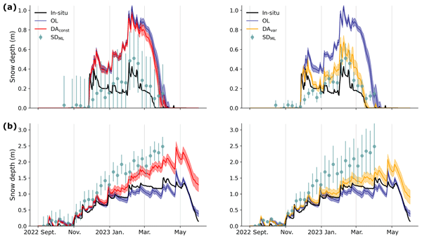
Devon Dunmire, Michel Bechtold, Lucas Boeykens, and Gabriëlle J. M. De Lannoy
The Cryosphere, 20, 609–628, https://doi.org/10.5194/tc-20-609-2026, https://doi.org/10.5194/tc-20-609-2026, 2026
Short summary
Short summary
Snow is vital for society and the climate, yet estimates of snowpack remain uncertain due to observational and modeling limitations. Data assimilation (DA) helps by integrating observations with models. Here, we integrate snow depth retrievals into a physically-based snow model across the European Alps. This work offers advancements for snow data assimilation, such as incorporating a dynamic observational uncertainty, which is essential for forecasting and water resource management.
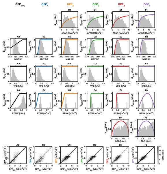
Rémi Madelon, K. Arthur Endsley, John S. Kimball, Gabriëlle J. M. De Lannoy, Oliver Sonnentag, Haley Alcock, Alex Mavrovic, Scott N. Williamson, Vincent Maire, Arnaud Mialon, and Alexandre Roy
Biogeosciences, 23, 6359–6407, https://doi.org/10.5194/bg-23-6359-2026, https://doi.org/10.5194/bg-23-6359-2026, 2026
Short summary
Short summary
This study aims to improve estimates of carbon dioxide release and uptake in the North American Arctic and subarctic regions. Several modeling approaches were tested, showing that a better representation of sunlight and temperature effects on ecosystems leads to improved estimates. This work provides new perspectives to better assess whether these regions act as sources or sinks of greenhouse gases and how they may influence the climate system by amplifying or slowing global warming.
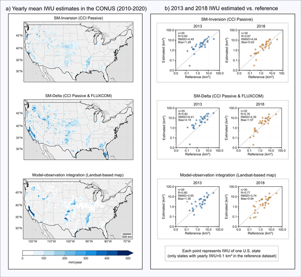
Pierre Laluet, Jacopo Dari, Louise Busschaert, Zdenko Heyvaert, Gabrielle De Lannoy, Pia Langhans, Sara Modanesi, Christian Massari, Luca Brocca, Carla Saltalippi, Renato Morbidelli, Clément Albergel, and Wouter Dorigo
Earth Syst. Sci. Data, 18, 4833–4853, https://doi.org/10.5194/essd-18-4833-2026, https://doi.org/10.5194/essd-18-4833-2026, 2026
Short summary
Short summary
We developed a long-term dataset collection of irrigation water use based on about two decades of satellite observations, three distinct approaches, and many input datasets. The collection provides monthly estimates for major agricultural regions and helps describe how irrigation varies across locations, seasons, and years. It offers a foundation for improving how irrigation is quantified, compared across methods, and integrated into large-scale hydrological and climate studies.
Francesco Avanzi, Hans Lievens, Michael Matiu, Paolo Filippucci, Oscar M. Baez Villanueva, Simone Gabellani, Fabio Delogu, Lorenzo Alfieri, Andrea Libertino, Pere Quintana-Seguì, Diego G. Miralles, Luca Brocca, Christian Massari, and Gabriëlle J. M. De Lannoy
EGUsphere, https://doi.org/10.5194/egusphere-2026-2851, https://doi.org/10.5194/egusphere-2026-2851, 2026
Short summary
Short summary
We developed a new system to map and monitor snow and stored water across large mountain regions using satellite data and computer simulations. Tested in four major European river basins, the system reproduced snow conditions with high accuracy and realistically captured how snow changes with elevation. Because it does not rely on ground measurements, it can help provide consistent information on snow-water resources worldwide, supporting water management and climate adaptation.
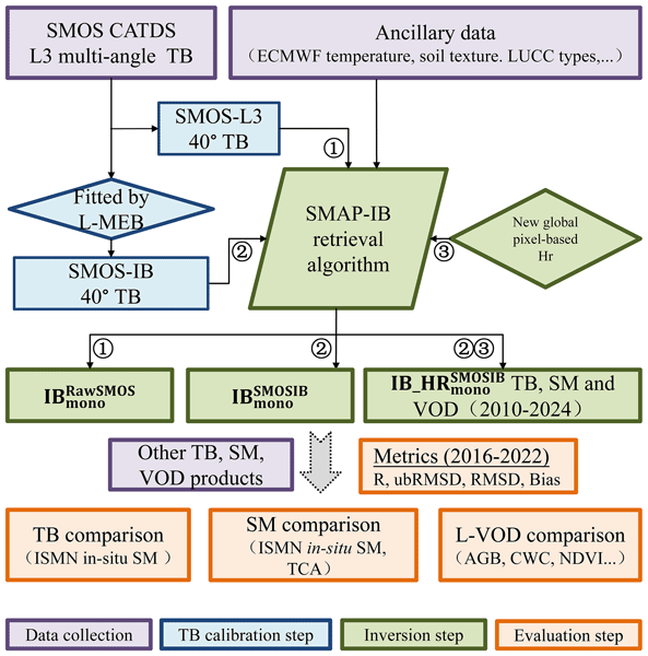
Zanpin Xing, Xiaojun Li, Frédéric Frappart, Gabrielle De Lannoy, Thomas Jagdhuber, Jian Peng, Lei Fan, Hongliang Ma, Lanka Karthikeyan, Xiangzhuo Liu, Mengjia Wang, Lin Zhao, Yongqin Liu, and Jean-Pierre Wigneron
Earth Syst. Sci. Data, 18, 4047–4073, https://doi.org/10.5194/essd-18-4047-2026, https://doi.org/10.5194/essd-18-4047-2026, 2026
Short summary
Short summary
Microwave satellite observations of Earth’s land surface are important for tracking global soil moisture and vegetation water content. We use data from the Soil Moisture and Ocean Salinity satellite to first reduce noise and contamination in microwave signals, then produce more reliable long-term records of these variables. Tests against ground stations and other satellites show that the new record performs better than existing products and supports drought, freeze-thaw, and carbon monitoring.
Louise Busschaert, Michel Bechtold, Sara Modanesi, Christian Massari, Dirk Raes, Sujay V. Kumar, and Gabriëlle J. M. De Lannoy
Hydrol. Earth Syst. Sci., 30, 2579–2611, https://doi.org/10.5194/hess-30-2579-2026, https://doi.org/10.5194/hess-30-2579-2026, 2026
Short summary
Short summary
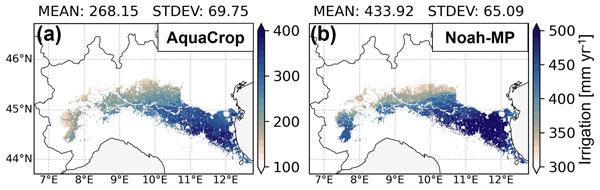
Two models, AquaCrop (crop model) and Noah-MP (land surface model), were compared estimating irrigation in Italy's Po Valley. Noah-MP simulated higher water use (434 mm/yr) than AquaCrop (268 mm/yr), mainly due to extra water losses like runoff. Once losses were accounted for, both aligned with basin-scale reports of around 500 to 600 mm/yr. The study highlights how complex irrigation modeling is, and the need for better observational data to validate results.
Gabriëlle J. M. De Lannoy, Louise Busschaert, Michel Bechtold, Niccolò Lanfranco, Shannon de Roos, Zdenko Heyvaert, Martynas Bielinis, Jonas Mortelmans, Samuel A. Scherrer, Maxime Van den Bossche, Sujay Kumar, David M. Mocko, Eric Kemp, Lee Heng, Pasquale Steduto, and Dirk Raes
Geosci. Model Dev., 19, 2551–2575, https://doi.org/10.5194/gmd-19-2551-2026, https://doi.org/10.5194/gmd-19-2551-2026, 2026
Short summary
Short summary
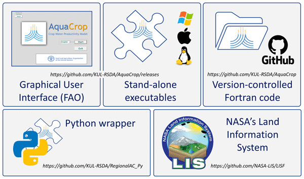
The AquaCrop model has been incorporated into the NASA Land Information System, to advance regional crop growth simulations at any spatial resolution, with a range of different input sources for meteorology, soil and crop parameters. This system also facilitates the assimilation of satellite data to update the crop and water conditions during model simulations. We present three exploratory applications to highlight pathways for future research on regional-scale crop estimation.
Anne Springer, Gabriëlle De Lannoy, Matthew Rodell, Yorck Ewerdwalbesloh, Helena Gerdener, Mehdi Khaki, Bailing Li, Fupeng Li, Maike Schumacher, Natthachet Tangdamrongsub, Mohammad J. Tourian, Wanshu Nie, and Jürgen Kusche
Hydrol. Earth Syst. Sci., 30, 985–1022, https://doi.org/10.5194/hess-30-985-2026, https://doi.org/10.5194/hess-30-985-2026, 2026
Short summary
Short summary
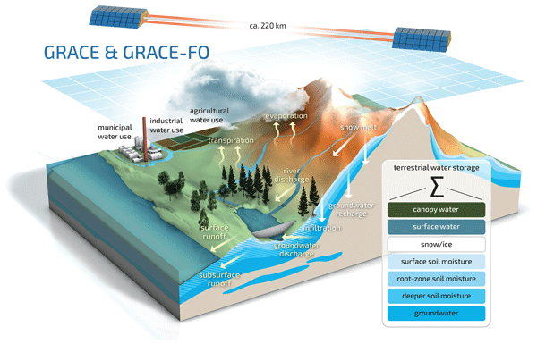
The GRACE (Gravity Recovery and Climate Experiment) and GRACE Follow-On satellites monitor changes in Earth's water storage by observing gravity variations. By integrating these observations into hydrological models through data assimilation, estimates of groundwater, soil moisture, and hydrological trends are improved, helping to monitor droughts, floods, and human water use. This review highlights recent advances in GRACE data assimilation, identifies key challenges, and discusses future directions with upcoming satellite missions.
Devon Dunmire, Michel Bechtold, Lucas Boeykens, and Gabriëlle J. M. De Lannoy
The Cryosphere, 20, 609–628, https://doi.org/10.5194/tc-20-609-2026, https://doi.org/10.5194/tc-20-609-2026, 2026
Short summary
Short summary
Snow is vital for society and the climate, yet estimates of snowpack remain uncertain due to observational and modeling limitations. Data assimilation (DA) helps by integrating observations with models. Here, we integrate snow depth retrievals into a physically-based snow model across the European Alps. This work offers advancements for snow data assimilation, such as incorporating a dynamic observational uncertainty, which is essential for forecasting and water resource management.
Paolo Nasta, Günter Blöschl, Heye R. Bogena, Steffen Zacharias, Roland Baatz, Gabriëlle De Lannoy, Karsten H. Jensen, Salvatore Manfreda, Laurent Pfister, Ana M. Tarquis, Ilja van Meerveld, Marc Voltz, Yijian Zeng, William Kustas, Xin Li, Harry Vereecken, and Nunzio Romano
Hydrol. Earth Syst. Sci., 29, 465–483, https://doi.org/10.5194/hess-29-465-2025, https://doi.org/10.5194/hess-29-465-2025, 2025
Short summary
Short summary
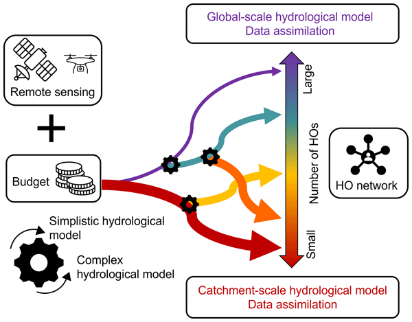
The Unsolved Problems in Hydrology (UPH) initiative has emphasized the need to establish networks of multi-decadal hydrological observatories to tackle catchment-scale challenges on a global scale. This opinion paper provocatively discusses two endmembers of possible future hydrological observatory (HO) networks for a given hypothesized community budget: a comprehensive set of moderately instrumented observatories or, alternatively, a small number of highly instrumented supersites.
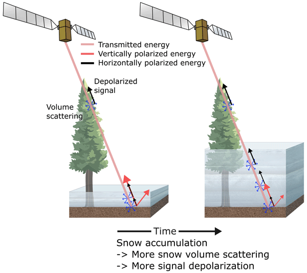
Zachary Hoppinen, Ross T. Palomaki, George Brencher, Devon Dunmire, Eric Gagliano, Adrian Marziliano, Jack Tarricone, and Hans-Peter Marshall
The Cryosphere, 18, 5407–5430, https://doi.org/10.5194/tc-18-5407-2024, https://doi.org/10.5194/tc-18-5407-2024, 2024
Short summary
Short summary
This study uses radar imagery from the Sentinel-1 satellite to derive snow depth from increases in the returning energy. These retrieved depths are then compared to nine lidar-derived snow depths across the western United State to assess the ability of this technique to be used to monitor global snow distributions. We also qualitatively compare the changes in underlying Sentinel-1 amplitudes against both the total lidar snow depths and nine automated snow monitoring stations.
Louise Busschaert, Michel Bechtold, Sara Modanesi, Christian Massari, Dirk Raes, Sujay V. Kumar, and Gabrielle J. M. De Lannoy
EGUsphere, https://doi.org/10.2139/ssrn.4974019, https://doi.org/10.2139/ssrn.4974019, 2024
Preprint archived
Short summary
Short summary
This study estimates irrigation in the Po Valley using AquaCrop and Noah-MP models with sprinkler irrigation. Noah-MP shows higher annual rates than AquaCrop due to more water losses. After adjusting, both align with reported irrigation ranges (500–600 mm/yr). Soil moisture estimates from both models match satellite data, though both have limitations in vegetation and evapotranspiration modeling. The study emphasizes the need for observations to improve irrigation estimates.
Firoz Kanti Borah, Jonas-Fredrick Jans, Zhenming Huang, Leung Tsang, Hans Lievens, and Edward Kim
EGUsphere, https://doi.org/10.5194/egusphere-2024-1825, https://doi.org/10.5194/egusphere-2024-1825, 2024
Preprint archived
Short summary
Short summary
In this paper, we study radar data collected by Sentinel-1 over mountain regions of Alps. Using physical models of snow and soil surface scattering, we show the reasons for the high sensitivity of cross-polarized observations with snow depth. This accurate modelling for cross-pol using physical models can be then used to retrieve snow depth at for very deep snow at mountain regions using the cross-pol signal.
Isis Brangers, Hans-Peter Marshall, Gabrielle De Lannoy, Devon Dunmire, Christian Mätzler, and Hans Lievens
The Cryosphere, 18, 3177–3193, https://doi.org/10.5194/tc-18-3177-2024, https://doi.org/10.5194/tc-18-3177-2024, 2024
Short summary
Short summary
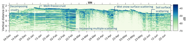
To better understand the interactions between C-band radar waves and snow, a tower-based experiment was set up in the Idaho Rocky Mountains. The reflections were collected in the time domain to measure the backscatter profile from the various snowpack and ground surface layers. The results demonstrate that C-band radar is sensitive to seasonal patterns in snow accumulation but that changes in microstructure, stratigraphy and snow wetness may complicate satellite-based snow depth retrievals.
Baoying Shan, Niko E. C. Verhoest, and Bernard De Baets
Hydrol. Earth Syst. Sci., 28, 2065–2080, https://doi.org/10.5194/hess-28-2065-2024, https://doi.org/10.5194/hess-28-2065-2024, 2024
Short summary
Short summary
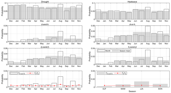
This study developed a convenient and new method to identify the occurrence of droughts, heatwaves, and co-occurring droughts and heatwaves (CDHW) across four seasons. Using this method, we could establish the start and/or end dates of drought (or heatwave) events. We found an increase in the frequency of heatwaves and CDHW events in Belgium caused by climate change. We also found that different months have different chances of CDHW events.
Jonas Mortelmans, Anne Felsberg, Gabriëlle J. M. De Lannoy, Sander Veraverbeke, Robert D. Field, Niels Andela, and Michel Bechtold
Nat. Hazards Earth Syst. Sci., 24, 445–464, https://doi.org/10.5194/nhess-24-445-2024, https://doi.org/10.5194/nhess-24-445-2024, 2024
Short summary
Short summary
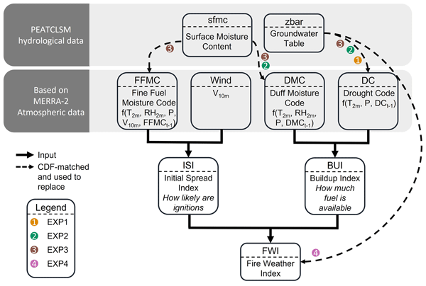
With global warming increasing the frequency and intensity of wildfires in the boreal region, accurate risk assessments are becoming more crucial than ever before. The Canadian Fire Weather Index (FWI) is a renowned system, yet its effectiveness in peatlands, where hydrology plays a key role, is limited. By incorporating groundwater data from numerical models and satellite observations, our modified FWI improves the accuracy of fire danger predictions, especially over summer.
Anne Felsberg, Zdenko Heyvaert, Jean Poesen, Thomas Stanley, and Gabriëlle J. M. De Lannoy
Nat. Hazards Earth Syst. Sci., 23, 3805–3821, https://doi.org/10.5194/nhess-23-3805-2023, https://doi.org/10.5194/nhess-23-3805-2023, 2023
Short summary
Short summary
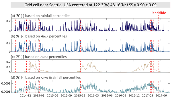
The Probabilistic Hydrological Estimation of LandSlides (PHELS) model combines ensembles of landslide susceptibility and of hydrological predictor variables to provide daily, global ensembles of hazard for hydrologically triggered landslides. Testing different hydrological predictors showed that the combination of rainfall and soil moisture performed best, with the lowest number of missed and false alarms. The ensemble approach allowed the estimation of the associated prediction uncertainty.
Samuel Scherrer, Gabriëlle De Lannoy, Zdenko Heyvaert, Michel Bechtold, Clement Albergel, Tarek S. El-Madany, and Wouter Dorigo
Hydrol. Earth Syst. Sci., 27, 4087–4114, https://doi.org/10.5194/hess-27-4087-2023, https://doi.org/10.5194/hess-27-4087-2023, 2023
Short summary
Short summary
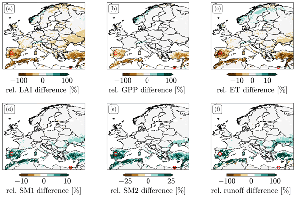
We explored different options for data assimilation (DA) of the remotely sensed leaf area index (LAI). We found strong biases between LAI predicted by Noah-MP and observations. LAI DA that does not take these biases into account can induce unphysical patterns in the resulting LAI and flux estimates and leads to large changes in the climatology of root zone soil moisture. We tested two bias-correction approaches and explored alternative solutions to treating bias in LAI DA.
Rajashree Tri Datta, Adam Herrington, Jan T. M. Lenaerts, David P. Schneider, Luke Trusel, Ziqi Yin, and Devon Dunmire
The Cryosphere, 17, 3847–3866, https://doi.org/10.5194/tc-17-3847-2023, https://doi.org/10.5194/tc-17-3847-2023, 2023
Short summary
Short summary
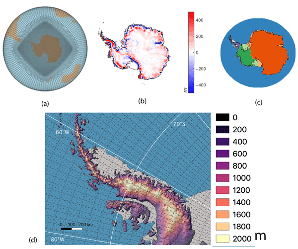
Precipitation over Antarctica is one of the greatest sources of uncertainty in sea level rise estimates. Earth system models (ESMs) are a valuable tool for these estimates but typically run at coarse spatial resolutions. Here, we present an evaluation of the variable-resolution CESM2 (VR-CESM2) for the first time with a grid designed for enhanced spatial resolution over Antarctica to achieve the high resolution of regional climate models while preserving the two-way interactions of ESMs.
Devon Dunmire, Jan T. M. Lenaerts, Rajashree Tri Datta, and Tessa Gorte
The Cryosphere, 16, 4163–4184, https://doi.org/10.5194/tc-16-4163-2022, https://doi.org/10.5194/tc-16-4163-2022, 2022
Short summary
Short summary
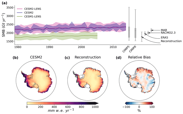
Earth system models (ESMs) are used to model the climate system and the interactions of its components (atmosphere, ocean, etc.) both historically and into the future under different assumptions of human activity. The representation of Antarctica in ESMs is important because it can inform projections of the ice sheet's contribution to sea level rise. Here, we compare output of Antarctica's surface climate from an ESM with observations to understand strengths and weaknesses within the model.
Sara Modanesi, Christian Massari, Michel Bechtold, Hans Lievens, Angelica Tarpanelli, Luca Brocca, Luca Zappa, and Gabriëlle J. M. De Lannoy
Hydrol. Earth Syst. Sci., 26, 4685–4706, https://doi.org/10.5194/hess-26-4685-2022, https://doi.org/10.5194/hess-26-4685-2022, 2022
Short summary
Short summary
Given the crucial impact of irrigation practices on the water cycle, this study aims at estimating irrigation through the development of an innovative data assimilation system able to ingest high-resolution Sentinel-1 radar observations into the Noah-MP land surface model. The developed methodology has important implications for global water resource management and the comprehension of human impacts on the water cycle and identifies main challenges and outlooks for future research.
Anne Felsberg, Jean Poesen, Michel Bechtold, Matthias Vanmaercke, and Gabriëlle J. M. De Lannoy
Nat. Hazards Earth Syst. Sci., 22, 3063–3082, https://doi.org/10.5194/nhess-22-3063-2022, https://doi.org/10.5194/nhess-22-3063-2022, 2022
Short summary
Short summary
In this study we assessed global landslide susceptibility at the coarse 36 km spatial resolution of global satellite soil moisture observations to prepare for a subsequent combination of the two. Specifically, we focus therefore on the susceptibility of hydrologically triggered landslides. We introduce ensemble techniques, common in, for example, meteorology but not yet in the landslide community, to retrieve reliable estimates of the total prediction uncertainty.

Louise Busschaert, Shannon de Roos, Wim Thiery, Dirk Raes, and Gabriëlle J. M. De Lannoy
Hydrol. Earth Syst. Sci., 26, 3731–3752, https://doi.org/10.5194/hess-26-3731-2022, https://doi.org/10.5194/hess-26-3731-2022, 2022
Short summary
Short summary
Increasing amounts of water are used for agriculture. Therefore, we looked into how irrigation requirements will evolve under a changing climate over Europe. Our results show that, by the end of the century and under high emissions, irrigation water will increase by 30 % on average compared to the year 2000. Also, the irrigation requirement is likely to vary more from 1 year to another. However, if emissions are mitigated, these effects are reduced.
Jorn Van de Velde, Matthias Demuzere, Bernard De Baets, and Niko E. C. Verhoest
Hydrol. Earth Syst. Sci., 26, 2319–2344, https://doi.org/10.5194/hess-26-2319-2022, https://doi.org/10.5194/hess-26-2319-2022, 2022
Short summary
Short summary
An important step in projecting future climate is the bias adjustment of the climatological and hydrological variables. In this paper, we illustrate how bias adjustment can be impaired by bias nonstationarity. Two univariate and four multivariate methods are compared, and for both types bias nonstationarity can be linked with less robust adjustment.
Hans Lievens, Isis Brangers, Hans-Peter Marshall, Tobias Jonas, Marc Olefs, and Gabriëlle De Lannoy
The Cryosphere, 16, 159–177, https://doi.org/10.5194/tc-16-159-2022, https://doi.org/10.5194/tc-16-159-2022, 2022
Short summary
Short summary
Snow depth observations at high spatial resolution from the Sentinel-1 satellite mission are presented over the European Alps. The novel observations can improve our knowledge of seasonal snow mass in areas with complex topography, where satellite-based estimates are currently lacking, and benefit a number of applications including water resource management, flood forecasting, and numerical weather prediction.
Sara Modanesi, Christian Massari, Alexander Gruber, Hans Lievens, Angelica Tarpanelli, Renato Morbidelli, and Gabrielle J. M. De Lannoy
Hydrol. Earth Syst. Sci., 25, 6283–6307, https://doi.org/10.5194/hess-25-6283-2021, https://doi.org/10.5194/hess-25-6283-2021, 2021
Short summary
Short summary
Worldwide, the amount of water used for agricultural purposes is rising and the quantification of irrigation is becoming a crucial topic. Land surface models are not able to correctly simulate irrigation. Remote sensing observations offer an opportunity to fill this gap as they are directly affected by irrigation. We equipped a land surface model with an observation operator able to transform Sentinel-1 backscatter observations into realistic vegetation and soil states via data assimilation.
Shannon de Roos, Gabriëlle J. M. De Lannoy, and Dirk Raes
Geosci. Model Dev., 14, 7309–7328, https://doi.org/10.5194/gmd-14-7309-2021, https://doi.org/10.5194/gmd-14-7309-2021, 2021
Short summary
Short summary
A spatially distributed version of the field-scale crop model AquaCrop v6.1 was developed for applications at various spatial scales. Multi-year 1 km simulations over central Europe were evaluated against biomass and surface soil moisture products derived from optical and microwave satellite missions, as well as in situ observations of soil moisture. The regional version of the AquaCrop model provides a suitable setup for subsequent satellite-based data assimilation.
Karen E. Alley, Christian T. Wild, Adrian Luckman, Ted A. Scambos, Martin Truffer, Erin C. Pettit, Atsuhiro Muto, Bruce Wallin, Marin Klinger, Tyler Sutterley, Sarah F. Child, Cyrus Hulen, Jan T. M. Lenaerts, Michelle Maclennan, Eric Keenan, and Devon Dunmire
The Cryosphere, 15, 5187–5203, https://doi.org/10.5194/tc-15-5187-2021, https://doi.org/10.5194/tc-15-5187-2021, 2021
Short summary
Short summary
We present a 20-year, satellite-based record of velocity and thickness change on the Thwaites Eastern Ice Shelf (TEIS), the largest remaining floating extension of Thwaites Glacier (TG). TG holds the single greatest control on sea-level rise over the next few centuries, so it is important to understand changes on the TEIS, which controls much of TG's flow into the ocean. Our results suggest that the TEIS is progressively destabilizing and is likely to disintegrate over the next few decades.
Cited articles
Abdulaal, M. J., Casson, A. J., and Gaydecki, P.: Performance of nested vs. non-nested SVM cross-validation methods in visual BCI: Validation Study, in: 2018 26th European Signal Processing Conference (EUSIPCO), 1680–1684, https://doi.org/10.23919/EUSIPCO.2018.8553102, 2018. a
Aureliano, P.: Perimeter of the Alpine Convention, https://www.atlas.alpconv.org/catalogue/csw_to_extra_format/ed3b3290-ca62-11ea-8743-0050568ea38e/Perimeter of the Alpine Convention.html (last access: 20 May 2026), 2020. a
Bales, R. C., Molotch, N. P., Painter, T. H., Dettinger, M. D., Rice, R., and Dozier, J.: Mountain hydrology of the western United States, Water Resour. Res., 42, https://doi.org/10.1029/2005WR004387, 2006. a
Barnett, T. P., Adam, J. C., and Lettenmaier, D. P.: Potential impacts of a warming climate on water availability in snow-dominated regions, Nature, 438, 303–309, https://doi.org/10.1038/nature04141, 2005. a
Bartelt, P. and Lehning, M.: A physical SNOWPACK model for the Swiss avalanche warning: Part I: numerical model, Cold Reg. Sci. Technol., 35, 123–145, https://doi.org/10.1016/S0165-232X(02)00074-5, 2002. a
Beck, H. E., Wood, E. F., Pan, M., Fisher, C. K., Miralles, D. G., van Dijk, A. I. J. M., McVicar, T. R., and Adler, R. F.: MSWEP V2 global 3-Hourly 0.1° precipitation: methodology and quantitative assessment, B. Am. Meteorol. Soc., 100, 473–500, https://doi.org/10.1175/BAMS-D-17-0138.1, 2019. a, b
Beck, H. E., van Dijk, A. I. J. M., Larraondo, P. R., McVicar, T. R., Pan, M., Dutra, E., and Miralles, D. G.: MSWX: global 3-Hourly 0.1° bias-corrected meteorological data including near-real-time updates and forecast ensembles, B. Am. Meteorol. Soc., 103, E710–E732, https://doi.org/10.1175/BAMS-D-21-0145.1, 2022. a, b
Blancas, E.: Model selection done right: A gentle introduction to nested cross-validation, https://ploomber.io/blog/nested-cv/ (last access: 2 June 2025), 2021. a
Boeykens, L.: Data for the figures and analyses performed in “Machine learning for snow depth estimation over the European Alps, using Sentinel-1 observations, meteorological forcing data and process-based model simulations” (Version v1), Zenodo [code and data set], https://doi.org/10.5281/zenodo.19697176, 2026. a
Bormann, K. J., Brown, R. D., Derksen, C., and Painter, T. H.: Estimating snow-cover trends from space, Nat. Clim. Change, 8, 924–928, https://doi.org/10.1038/s41558-018-0318-3, 2018. a, b, c
Brangers, I., Lievens, H., Getirana, A., and De Lannoy, G. J. M.: Sentinel-1 snow depth assimilation to improve river discharge estimates in the western European Alps, Water Resour. Res., 60, e2023WR035019, https://doi.org/10.1029/2023WR035019, 2024a. a
Brangers, I., Marshall, H.-P., De Lannoy, G., Dunmire, D., Mätzler, C., and Lievens, H.: Tower-based C-band radar measurements of an alpine snowpack, The Cryosphere, 18, 3177–3193, https://doi.org/10.5194/tc-18-3177-2024, 2024b. a, b
Broxton, P., Ehsani, M. R., and Behrangi, A.: Improving mountain snowpack estimation using machine learning with Sentinel-1, the Airborne Snow Observatory, and University of Arizona snowpack data, Earth and Space Science, 11, e2023EA002964, https://doi.org/10.1029/2023EA002964, 2024. a
Buchhorn, M., Smets, B., Bertels, L., De Roo, B., Lesiv, M., Tsendbazar, N.-E., Herold, M., and Fritz, S.: Copernicus global land service: land cover 100 m: collection 3: epoch 2018: Globe, https://doi.org/10.5281/zenodo.3518038, 2020. a
Bührle, L., Ruttner, P., Marty, M., and Bühler, Y.: Snow depth mapping by airplane photogrammetry (2017–ongoing), EnviDat [data set], https://doi.org/10.16904/envidat.418, 2022. a
Bührle, L. J., Marty, M., Eberhard, L. A., Stoffel, A., Hafner, E. D., and Bühler, Y.: Spatially continuous snow depth mapping by aeroplane photogrammetry for annual peak of winter from 2017 to 2021 in open areas, The Cryosphere, 17, 3383–3408, https://doi.org/10.5194/tc-17-3383-2023, 2023. a, b
Burakowski, E. and Magnusson, M.: Climate impacts on the winter tourism economy in the United States, https://uvpublichealth.org/wp-content/uploads/2016/02/climate-impacts-winter-tourism-report.pdf (last access: 20 May 2026), 2012. a
CDSE: Copernicus DEM – Global and European Digital Elevation Model, CDSE [data set], https://doi.org/10.5270/ESA-c5d3d65, 2026. a
Charbonneau, A., Deck, K., and Schneider, T.: A Physics-Constrained Neural Differential Equation Framework for Data-Driven Snowpack Simulation, Artificial Intelligence for the Earth Systems, 4, https://doi.org/10.1175/aies-d-24-0040.1, 2025. a
Chen, T. and Guestrin, C.: XGBoost: A scalable tree boosting system, in: Proceedings of the 22nd ACM SIGKDD international conference on knowledge discovery and data mining, Association for Computing Machinery, New York, NY, USA, 785–794, https://doi.org/10.1145/2939672.2939785, 2016. a, b, c
Cloude, S. and Pottier, E.: An entropy based classification scheme for land applications of polarimetric SAR, IEEE T. Geosci. Remote, 35, 68–78, https://doi.org/10.1109/36.551935, 1997. a
Copernicus Land Monitoring Service: SAR wet snow 2016–present (raster 60 m), Europe, daily, Copernicus Land Monitoring Service [data set], https://doi.org/10.2909/cd23c4bb-b3cb-4331-bb89-93321b46f8ed, 2024. a, b
Craymer, M.: Geodetic toolbox, MATLAB Central File Exchange, https://nl.mathworks.com/matlabcentral/fileexchange/15285-geodetic-toolbox (last access: 20 May 2026), 2022. a
Daudt, R. C., Wulf, H., Hafner, E. D., Bühler, Y., Schindler, K., and Wegner, J. D.: Snow depth estimation at country-scale with high spatial and temporal resolution, ISPRS J. Photogramm., 197, 105–121, https://doi.org/10.1016/j.isprsjprs.2023.01.017, 2023. a
Deems, J. S., Painter, T. H., and Finnegan, D. C.: Lidar measurement of snow depth: A review, J. Glaciol., 59, 467–479, https://doi.org/10.3189/2013JoG12J154, 2013. a, b
De Lannoy, G. J. M., Bechtold, M., Busschaert, L., Heyvaert, Z., Modanesi, S., Dunmire, D., Lievens, H., Getirana, A., and Massari, C.: Contributions of irrigation modeling, soil moisture and snow data assimilation to high-resolution water budget estimates over the Po basin: Progress towards digital replicas, J. Adv. Model. Earth Sy., 16, e2024MS004433, https://doi.org/10.1029/2024MS004433, 2024. a
Dora, L., Agrawal, S., Panda, R., and Abraham, A.: Nested cross-validation based adaptive sparse representation algorithm and its application to pathological brain classification, Expert Syst. Appl., 114, 313–321, https://doi.org/10.1016/j.eswa.2018.07.039, 2018. a
Dozier, J., Bair, E. H., and Davis, R. E.: Estimating the spatial distribution of snow water equivalent in the world's mountains, WIRes Water, 3, 461–474, https://doi.org/10.1002/wat2.1140, 2016. a, b, c, d
Duan, S., Ullrich, P., Risser, M., and Rhoades, A.: Using temporal deep learning models to estimate daily snow water equivalent over the Rocky Mountains, Water Resour. Res., 60, e2023WR035009, https://doi.org/10.1029/2023WR035009, 2024. a
Dunmire, D., Bechtold, M., Boeykens, L., and De Lannoy, G. J. M.: Advancing snow data assimilation with a dynamic observation uncertainty, The Cryosphere, 20, 609–628, https://doi.org/10.5194/tc-20-609-2026, 2026. a
Essery, R.: A factorial snowpack model (FSM 1.0), Geosci. Model Dev., 8, 3867–3876, https://doi.org/10.5194/gmd-8-3867-2015, 2015. a
Essery, R., Morin, S., Lejeune, Y., and Ménard, C. B.: A comparison of 1701 snow models using observations from an alpine site, Adv. Water Resour., 55, 131–148, https://doi.org/10.1016/j.advwatres.2012.07.013, 2013. a
Fiddes, J. and Gruber, S.: TopoSCALE v.1.0: downscaling gridded climate data in complex terrain, Geosci. Model Dev., 7, 387–405, https://doi.org/10.5194/gmd-7-387-2014, 2014. a
Fontrodona-Bach, A., Schaefli, B., Woods, R., Teuling, A. J., and Larsen, J. R.: NH-SWE: Northern Hemisphere Snow Water Equivalent dataset based on in situ snow depth time series, Earth Syst. Sci. Data, 15, 2577–2599, https://doi.org/10.5194/essd-15-2577-2023, 2023. a
Gascoin, S., Luojus, K., Nagler, T., Lievens, H., Masiokas, M., Jonas, T., Zheng, Z., and De Rosnay, P.: Remote sensing of mountain snow from space: Status and recommendations, Front. Earth Sci., 12, 1381323, https://doi.org/10.3389/feart.2024.1381323, 2024. a, b
Global Climate Observing System: Snow – Essential Climate Variables, https://gcos.wmo.int/site/global-climate-observing-system-gcos/essential-climate-variables/snow, last access: 21 January 2026. a
Goodarzi, M. R., Barzkar, A., Sabaghzadeh, M., Ghanbari, M., and Fathollahzadeh Attar, N.: Uncertainty Analysis of Machine Learning Methods To Estimate Snow Water Equivalent Using Meteorological and Remote Sensing Data, Water Resour. Manag., 39, 4471–4491, https://doi.org/10.1007/s11269-025-04164-z, 2025. a
Groisman, P. Y., Karl, T. R., Knight, R. W., and Stenchikov, G. L.: Changes of snow cover, temperature, and radiative heat balance over the Northern Hemisphere, J. Climate, 7, 1633–1656, https://doi.org/10.1175/1520-0442(1994)007<1633:COSCTA>2.0.CO;2, 1994. a
Hall, D. and Riggs, G.: MODIS/Aqua CGF Snow Cover Daily L3 Global 500 m SIN Grid, Version 61, https://doi.org/10.5067/MODIS/MYD10A1F.061, 2020a. a
Hall, D. and Riggs, G.: MODIS/Terra CGF Snow Cover Daily L3 Global 500 m SIN Grid, Version 61, https://doi.org/10.5067/MODIS/MOD10A1F.061, 2020b. a
Hill, D. F., Burakowski, E. A., Crumley, R. L., Keon, J., Hu, J. M., Arendt, A. A., Wikstrom Jones, K., and Wolken, G. J.: Converting snow depth to snow water equivalent using climatological variables, The Cryosphere, 13, 1767–1784, https://doi.org/10.5194/tc-13-1767-2019, 2019. a
Huss, M., Sold, L., Hoelzle, M., Stokvis, M., Salzmann, N., Farinotti, D., and Zemp, M.: Towards remote monitoring of sub-seasonal glacier mass balance, Ann. Glaciol., 54, 75–83, https://doi.org/10.3189/2013AoG63A427, 2013. a, b
Intercantonal Measurement and Information System IMIS: IMIS measuring network, EnviDat [data set], https://doi.org/10.16904/envidat.406, 2023. a
Jans, J.-F., Beernaert, E., De Breuck, M., Brangers, I., Dunmire, D., De Lannoy, G., and Lievens, H.: Sensitivity of Sentinel-1 C-band SAR backscatter, polarimetry and interferometry to snow accumulation in the Alps, Remote Sens. Environ., 316, 114477, https://doi.org/10.1016/j.rse.2024.114477, 2025. a, b, c, d, e, f, g, h, i
Jennings, K. S., Winchell, T. S., Livneh, B., and Molotch, N. P.: Spatial variation of the rain–snow temperature threshold across the Northern Hemisphere, Nat. Commun., 9, 1148, https://doi.org/10.1038/s41467-018-03629-7, 2018. a
Landschoot, S., Waegeman, W., Audenaert, K., Vandepitte, J., Haesaert, G., and De Baets, B.: Toward a reliable evaluation of forecasting systems for plant diseases: A case study using Fusarium head blight of wheat, Plant Dis., 96, 889–896, https://doi.org/10.1094/PDIS-08-11-0665, 2012. a
Largeron, C., Dumont, M., Morin, S., Boone, A., Lafaysse, M., Metref, S., Cosme, E., Jonas, T., Winstral, A., and Margulis, S. A.: Toward Snow Cover Estimation in Mountainous Areas Using Modern Data Assimilation Methods: A Review, Front. Earth Sci., 8, https://doi.org/10.3389/feart.2020.00325, 2020. a
Lievens, H., Demuzere, M., Marshall, H.-P., Reichle, R. H., Brucker, L., Brangers, I., de Rosnay, P., Dumont, M., Girotto, M., Immerzeel, W. W., Jonas, T., Kim, E. J., Koch, I., Marty, C., Saloranta, T., Schöber, J., and De Lannoy, G. J. M.: Snow depth variability in the Northern Hemisphere mountains observed from space, Nat. Commun., 10, 1–12, https://doi.org/10.1038/s41467-019-12566-y, 2019. a, b, c
Liston, G. E. and Elder, K.: A Distributed Snow-Evolution Modeling System (SnowModel), J. Hydrometeorol., 7, 1259–1276, https://doi.org/10.1175/JHM548.1, 2006a. a
Liston, G. E. and Elder, K.: A meteorological distribution system for high-resolution terrestrial modeling (MicroMet), J. Hydrometeorol., 7, 217–234, https://doi.org/10.1175/JHM486.1, 2006b. a, b
López-Moreno, J. I., Revuelto, J., Fassnacht, S. R., Azorín-Molina, C., Vicente-Serrano, S. M., Morán-Tejeda, E., and Sexstone, G. A.: Snowpack variability across various spatio-temporal resolutions, Hydrol. Process., 29, 1213–1224, https://doi.org/10.1002/hyp.10245, 2015. a, b
Lundberg, S. M. and Lee, S.-I.: A unified approach to interpreting model predictions, in: Proceedings of the 31st International Conference on Neural Information Processing Systems, NIPS'17, Curran Associates Inc., Red Hook, NY, USA, arXiv [preprint], https://doi.org/10.48550/arXiv.1705.07874, 2017. a
Lundblad, E. R., Wright, D. J., Miller, J., Larkin, E. M., Rinehart, R., Naar, D. F., Donahue, B. T., Anderson, S. M., and Battista, T.: A benthic terrain classification scheme for American Samoa, Mar. Geod., 29, 89–111, https://doi.org/10.1080/01490410600738021, 2006. a
Marin, C., Bertoldi, G., Premier, V., Callegari, M., Brida, C., Hürkamp, K., Tschiersch, J., Zebisch, M., and Notarnicola, C.: Use of Sentinel-1 radar observations to evaluate snowmelt dynamics in alpine regions, The Cryosphere, 14, 935–956, https://doi.org/10.5194/tc-14-935-2020, 2020. a
Marks, D. and Dozier, J.: Climate and energy exchange at the snow surface in the alpine region of the Sierra Nevada: 2. Snow cover energy balance, Water Resour. Res., 28, 3043–3054, https://doi.org/10.1029/92WR01483, 1992. a
Marty, M., Bühler, Y., and Ginzler, C.: Snow depth mapping, https://doi.org/10.16904/envidat.62, 2019a. a, b
Marty, M., Bühler, Y., and Ginzler, C.: Snow Depth Mapping, EnviDat [data set], https://doi.org/10.16904/envidat.62, 2019. a
Matiu, M., Crespi, A., Bertoldi, G., Carmagnola, C. M., Marty, C., Morin, S., Schöner, W., Cat Berro, D., Chiogna, G., De Gregorio, L., Kotlarski, S., Majone, B., Resch, G., Terzago, S., Valt, M., Beozzo, W., Cianfarra, P., Gouttevin, I., Marcolini, G., Notarnicola, C., Petitta, M., Scherrer, S. C., Strasser, U., Winkler, M., Zebisch, M., Cicogna, A., Cremonini, R., Debernardi, A., Faletto, M., Gaddo, M., Giovannini, L., Mercalli, L., Soubeyroux, J.-M., Sušnik, A., Trenti, A., Urbani, S., and Weilguni, V.: Observed snow depth trends in the European Alps: 1971 to 2019, The Cryosphere, 15, 1343–1382, https://doi.org/10.5194/tc-15-1343-2021, 2021. a, b
Menne, M. J., Durre, I., Vose, R. S., Gleason, B. E., and Houston, T. G.: An Overview of the Global Historical Climatology Network-Daily Database, J. Atmos. Ocean. Tech., 29, 897–910, https://doi.org/10.1175/JTECH-D-11-00103.1, 2012. a
Meyer, H., Reudenbach, C., Hengl, T., Katurji, M., and Nauss, T.: Improving performance of spatio-temporal machine learning models using forward feature selection and target-oriented validation, Environ. Modell. Softw., 101, 1–9, https://doi.org/10.1016/j.envsoft.2017.12.001, 2018. a
Miller, Z. S., Peitzsch, E. H., Sproles, E. A., Birkeland, K. W., and Palomaki, R. T.: Assessing the seasonal evolution of snow depth spatial variability and scaling in complex mountain terrain, The Cryosphere, 16, 4907–4930, https://doi.org/10.5194/tc-16-4907-2022, 2022. a, b, c
Notarnicola, C.: Overall negative trends for snow cover extent and duration in global mountain regions over 1982–2020, Sci. Rep.-UK, 12, 13731, https://doi.org/10.1038/s41598-022-16743-w, 2022. a
Painter, T. H., Berisford, D. F., Boardman, J. W., Bormann, K. J., Deems, J. S., Gehrke, F., Hedrick, A., Joyce, M., Laidlaw, R., Marks, D., Mattmann, C., McGurk, B., Ramirez, P., Richardson, M., McKenzie Skiles, S., Seidel, F. C., and Winstral, A.: The Airborne Snow Observatory: Fusion of scanning lidar, imaging spectrometer, and physically-based modeling for mapping snow water equivalent and snow albedo, Remote Sens. Environ., 184, 139–152, https://doi.org/10.1016/j.rse.2016.06.018, 2016. a
Parthum, B. and Christensen, P.: A market for snow: Modeling winter recreation patterns under current and future climate, J. Environ. Econ. Manag., 113, 102637, https://doi.org/10.1016/j.jeem.2022.102637, 2022. a
Parvandeh, S., Yeh, H.-W., Paulus, M. P., and McKinney, B. A.: Consensus features nested cross-validation, Bioinformatics, 36, 3093–3098, https://doi.org/10.1093/bioinformatics/btaa046, 2020. a
Pedregosa, F., Varoquaux, G., Gramfort, A., Michel, V.and Thirion, B., Grisel, O., Blondel, M., Prettenhofer, P., Weiss, R., Dubourg, V., Vanderplas, J., Passos, A., Cournapeau, D., Brucher, M., Perrot, M., and Duchesnay, E.: Scikit-learn: Machine learning in Python, J. Mach. Learn. Res., 12, 2825–2830, 2011. a
Pomarol Moya, O., Nussbaum, M., Mehrkanoon, S., Kraaijenbrink, P. D. A., Gouttevin, I., Karssenberg, D., and Immerzeel, W. W.: Improving snow water equivalent modelling: a comparative study of hybrid machine learning techniques, The Cryosphere, 20, 1427–1444, https://doi.org/10.5194/tc-20-1427-2026, 2026. a
PyCaret: PyCaret: An open-source, low-code machine learning library, Version 1.0.0, https://www.pycaret.org/ (last access: 20 May 2026), 2020. a
Qin, Y., Abatzoglou, J. T., Siebert, S., Huning, L. S., AghaKouchak, A., Mankin, J. S., Hong, C., Tong, D., Davis, S. J., and Mueller, N. D.: Agricultural risks from changing snowmelt, Nat. Clim. Change, 10, 459–465, https://doi.org/10.1038/s41558-020-0746-8, 2020. a
RGI 7.0 Consortium: Randolph glacier inventory – A dataset of global glacier uutlines, Version 7.0, https://doi.org/10.5067/f6jmovy5navz, 2023. a
Ryken, A., Bearup, L. A., Jefferson, J. L., Constantine, P., and Maxwell, R. M.: Sensitivity and model reduction of simulated snow processes: Contrasting observational and parameter uncertainty to improve prediction, Adv. Water Resour., 135, 103473, https://doi.org/10.1016/j.advwatres.2019.103473, 2020. a
Schwanghart, W. and Scherler, D.: Short Communication: TopoToolbox 2 – MATLAB-based software for topographic analysis and modeling in Earth surface sciences, Earth Surf. Dynam., 2, 1–7, https://doi.org/10.5194/esurf-2-1-2014, 2014. a
Seeherman, J. and Liu, Y.: Effects of extraordinary snowfall on traffic safety, Accident Anal. Prev., 81, 194–203, https://doi.org/10.1016/j.aap.2015.04.029, 2015. a
Small, D.: Flattening gamma: Radiometric terrain correction for SAR imagery, IEEE T. Geosci. Remote, 49, 3081–3093, https://doi.org/10.1109/TGRS.2011.2120616, 2011. a
Sturm, M. and Liston, G. E.: Revisiting the Global Seasonal Snow Classification: An Updated Dataset for Earth System Applications, J. Hydrometeorol., 22, 2917–2938, https://doi.org/10.1175/JHM-D-21-0070.1, 2021. a, b, c
Sturm, M., Goldstein, M. A., and Parr, C.: Water and life from snow: A trillion dollar science question, Water Resour. Res., 53, 3534–3544, https://doi.org/10.1002/2017WR020840, 2017. a, b
Tedesco, M. and Narvekar, P. S.: Assessment of the NASA AMSR-E SWE product, IEEE J. Sel. Top. Appl., 3, 141–159, https://doi.org/10.1109/JSTARS.2010.2040462, 2010. a
Terzago, S., Andreoli, V., Arduini, G., Balsamo, G., Campo, L., Cassardo, C., Cremonese, E., Dolia, D., Gabellani, S., von Hardenberg, J., Morra di Cella, U., Palazzi, E., Piazzi, G., Pogliotti, P., and Provenzale, A.: Sensitivity of snow models to the accuracy of meteorological forcings in mountain environments, Hydrol. Earth Syst. Sci., 24, 4061–4090, https://doi.org/10.5194/hess-24-4061-2020, 2020. a
Tsai, Y.-L. S., Dietz, A., Oppelt, N., and Kuenzer, C.: Wet and dry snow detection using Sentinel-1 SAR data for mountainous areas with a machine learning technique, Remote Sens.-Basel, 11, 895, https://doi.org/10.3390/rs11080895, 2019. a
Tsang, L., Durand, M., Derksen, C., Barros, A. P., Kang, D.-H., Lievens, H., Marshall, H.-P., Zhu, J., Johnson, J., King, J., Lemmetyinen, J., Sandells, M., Rutter, N., Siqueira, P., Nolin, A., Osmanoglu, B., Vuyovich, C., Kim, E., Taylor, D., Merkouriadi, I., Brucker, L., Navari, M., Dumont, M., Kelly, R., Kim, R. S., Liao, T.-H., Borah, F., and Xu, X.: Review article: Global monitoring of snow water equivalent using high-frequency radar remote sensing, The Cryosphere, 16, 3531–3573, https://doi.org/10.5194/tc-16-3531-2022, 2022. a, b, c, d
U.S. National Ice Center: IMS daily Northern Hemisphere snow and ice analysis at 4 km and 24 km resolution, National Snow and Ice Data Center, https://doi.org/10.7265/N52R3PMC, 2008. a
Varade, D., Singh, G., Dikshit, O., and Manickam, S.: Identification of snow using fully polarimetric SAR data based on entropy and anisotropy, Water Resour. Res., 56, e2019WR025449, https://doi.org/10.1029/2019WR025449, 2020. a
Wang, F. and Tian, D.: Multivariate bias correction and downscaling of climate models with trend-preserving deep learning, Clim. Dynam., 62, 9651–9672, https://doi.org/10.1007/s00382-024-07406-9, 2024. a
Warren, S. G.: Optical properties of snow, Rev. Geophys., 20, 67–89, https://doi.org/10.1029/RG020i001p00067, 1982. a
Weiss, A.: Topographic position and landforms analysis, in: Poster presentation, vol. 200, ESRI user conference, San Diego, CA, https://env761.github.io/assets/files/tpi-poster-tnc_18x22.pdf (last access: 19 May 2026), 2001. a
World Meteorological Organization: Rapid changes in cryosphere demand urgent, coordinated action, https://wmo.int/news/media-centre/rapid-changes-cryosphere-demand-urgent-coordinated-action (last access: 20 May 2026), 2023. a
WSL Institute for Snow and Avalanche Research SLF: Manual measuring network, EnviDat [data set], https://doi.org/10.16904/envidat.408, 2023. a
Xiong, C., Yang, J., Pan, J., Lei, Y., and Shi, J.: Mountain snow depth retrieval from optical and passive microwave remote sensing using machine learning, IEEE Geosci. Remote S., 19, 1–5, https://doi.org/10.1109/LGRS.2022.3226204, 2022. a
Short summary
We used AI to better estimate the height of the snowpack present on the ground across the European Alps, by using novel satellite data, complemented by weather information or snow depth estimates from a computer model. We found that both combinations improve the accuracy of our AI-based snow depth estimates, performing almost equally well. This helps us better monitor how much water is stored as snow, which is vital for drinking water, farming, and clean energy production in Europe.
We used AI to better estimate the height of the snowpack present on the ground across the...


