the Creative Commons Attribution 4.0 License.
the Creative Commons Attribution 4.0 License.
 | 20 Oct 2025
Review article: AntArchitecture – building an age–depth model from Antarctica's radiostratigraphy to explore ice-sheet evolution
Julien A. Bodart
Marie G. P. Cavitte
Ailsa Chung
Rebecca J. Sanderson
Johannes C. R. Sutter
Olaf Eisen
Nanna B. Karlsson
Joseph A. MacGregor
Neil Ross
Duncan A. Young
David W. Ashmore
Andreas Born
Winnie Chu
Xiangbin Cui
Reinhard Drews
Steven Franke
Vikram Goel
John W. Goodge
A. Clara J. Henry
Antoine Hermant
Benjamin H. Hills
Nicholas Holschuh
Michelle R. Koutnik
Gwendolyn J.-M. C. Leysinger Vieli
Emma J. MacKie
Elisa Mantelli
Carlos Martín
Felix S. L. Ng
Falk M. Oraschewski
Felipe Napoleoni
Frédéric Parrenin
Sergey V. Popov
Therese Rieckh
Rebecca Schlegel
Dustin M. Schroeder
Martin J. Siegert
Xueyuan Tang
Thomas O. Teisberg
Kate Winter
Shuai Yan
Harry Davis
Christine F. Dow
Tyler J. Fudge
Tom A. Jordan
Bernd Kulessa
Kenichi Matsuoka
Clara J. Nyqvist
Maryam Rahnemoonfar
Matthew R. Siegfried
Shivangini Singh
Vjeran Višnjević
Rodrigo Zamora
Alexandra Zuhr
Radio-echo sounding (RES) has revealed an internal architecture within both the West and East Antarctic ice sheets that records their depositional, deformational and melting histories. Crucially, RES-imaged internal-reflecting horizons, tied to ice-core age–depth profiles, can be treated as isochrones that record the age–depth structure across the Antarctic ice sheets. These enable the reconstruction of past climate and ice dynamical processes on large scales, which are complementary to but more spatially extensive than commonly used proxy records (e.g. former ice limits constrained by cosmogenic dating or offshore sediment sequences) around Antarctica. We review the progress towards building a pan-Antarctic age–depth model from these data by first introducing the relevant RES datasets that have been acquired across Antarctica over the last 6 decades (focussing specifically on those that detected internal-reflecting horizons) and outlining the processing steps typically undertaken to visualise, trace and date (by intersection with ice cores or modelling) the RES-imaged isochrones. We summarise the scientific applications for which Antarctica's internal architecture has been used to date and present a pathway to expanding Antarctic radiostratigraphy across the continent to provide a benchmark for a wider range of investigations: (1) identification of optimal sites for retrieving new ice-core palaeoclimate records targeting different periods; (2) reconstruction of surface mass balance on millennial or historical timescales; (3) estimation of basal melting and geothermal heat flux from radiostratigraphy and comprehensive mapping of basal-ice units to complement inferences from other geophysical and geological methods; (4) advancement of the knowledge of volcanic activity and fallout across Antarctica; and (5) refinement of numerical models that leverage radiostratigraphy to tune time-varying accumulation, basal melting and ice flow, firstly to reconstruct past behaviour and then to reduce uncertainties in projecting future ice-sheet behaviour.
- Article
(17983 KB) - Full-text XML
- BibTeX
- EndNote


Throughout the Quaternary (2.58 Ma to present), Antarctica's ice cover has waxed and waned, inducing concomitant rises and falls in global sea level on the order of several tens of metres (e.g. Drewry, 1983; Pollard and DeConto, 2009; Dutton et al., 2015). It is critical to understand the rates and drivers of these past oscillations in order to contextualise current observations of persistent and accelerating losses from the contemporary Antarctic ice sheets (e.g. Fox-Kemper et al., 2021; Otosaka et al., 2023) and, thereby, to project as accurately as possible the rates at which future global sea-level rise fuelled by ice melt will occur (e.g. Scambos et al., 2017; Oppenheimer et al., 2019). The evidence for past Antarctic ice-sheet fluctuations has been derived predominantly from sampling sediments deposited offshore around the continent (Escutia et al., 2009; Naish et al., 2009; Cook et al., 2013; Bentley et al., 2014; Gulick et al., 2017; Hillenbrand et al., 2017), dating the exposure history of onshore bedrock and moraine boulders (Brook and Kurz, 1993; Stone et al., 2003; Johnson et al., 2008; Mackintosh et al., 2014; Hein et al., 2016; Hillebrand et al., 2021), and analysing the ice recovered from ice-core sites itself (e.g. EPICA Community Members, 2004; Jouzel et al., 2007; Higgins et al., 2015; WAIS Divide Project Members, 2015; Dome Fuji Ice Core Project Members, 2017; Yan et al., 2021) (see Brook and Buizert, 2018, for an overview). Together, these form the palaeoclimate records that underpin numerical-modelling reconstructions of past and present ice-sheet extents and inform projections of how these may evolve into the future and affect sea-level change (e.g. Gasson et al., 2016; Golledge et al., 2019; DeConto et al., 2021; Pittard et al., 2022). Recovery of further sediment and ice cores around Antarctica to refine these records and projections remains a scientific imperative – and, yet, these records are intrinsically spatially limited; are often restricted in terms of the timescales of observation; and, for the most part, are indirect with respect to ice conditions. Radio-echo sounding across Antarctica complements these records by providing spatially continuous data that record past and present ice conditions and, by extension, past and present climate conditions across the ice sheets.
Radio-echo sounding (RES) describes the investigation of the subsurface of ice sheets using electromagnetic waves and has been conducted from both airborne and ground-based platforms across the Antarctic ice sheets for over 60 years (see reviews by Dowdeswell and Evans, 2004; Bingham and Siegert, 2007; Allen, 2008; Schroeder et al., 2020). Primarily deployed for mapping the ice-sheet bed and thereby measuring ice thickness and, thus, ice volume, the majority of RES surveys have also imaged numerous englacial features, predominantly internal-reflection horizons (a.k.a. internal or englacial layers), crevasses and rheologically distinct “basal units” of ice that occur between the more obvious reflections of the ice surface and the ice bed (Fig. 1). For this review, we collectively term all of the Antarctic ice sheets' RES-imaged englacial features as “internal architecture”. We will demonstrate that, although great progress has already been made in using some of this resource to elucidate ice and climate history, Antarctica's internal architecture has yet to be exploited to its full potential in refining our understanding of past, present and future ice-sheet behaviour.
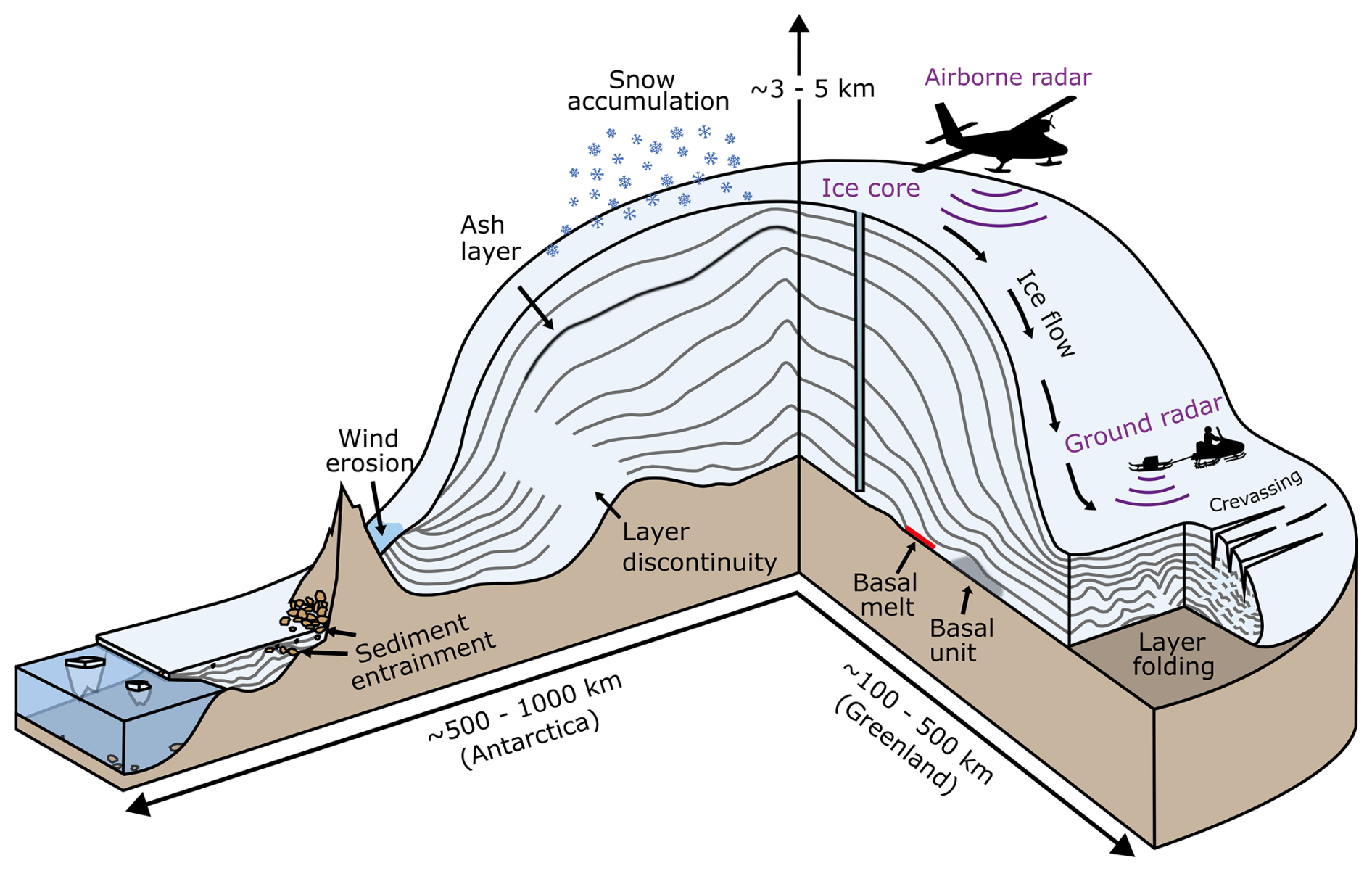
Figure 1Schematic illustration of Antarctica's internal architecture and the key processes governing its structure. Internal-reflection horizons – the ice sheet's “radiostratigraphy” – are represented by the grey lines between the surface and bed.
In Greenland, a comprehensive archive of internal architecture has already been assembled (see MacGregor et al., 2015a, 2025), facilitating the ice-sheet-wide reconstruction of past accumulation and dynamics to improve past and future sea-level estimates (MacGregor et al., 2016; Born and Robinson, 2021). However, several major issues have confounded progress in capturing and applying internal architecture across Antarctica, including the following:
-
Together, the Antarctic ice sheets cover 8 times the area of the Greenland Ice Sheet.
-
RES data have been collected, processed and archived by multiple international groups across the Antarctic ice sheets and, hence, are not available in a standardised form across Antarctica.
-
A comprehensive suite of strategies for using internal architecture in numerical ice-sheet models has not been developed.
-
Much internal architecture in RES data is highly challenging to identify and map with automated methods.
To address these challenges and to work collectively towards consistently capturing and utilising Antarctica's internal architecture, an international community called AntArchitecture was formed in 2018. This community, coordinated via the Scientific Committee for Antarctic Research (SCAR), aspires to the ultimate scientific aim of using Antarctica's internal architecture to deconvolve its ice sheets' histories and thereby facilitate improved projections of their future behaviour in the face of global climate warming. A first step in this process – and one of the aims of this review, collectively written by the AntArchitecture community – is to compile the international community's understanding of the present state of the field in terms of available RES data across the Antarctic ice sheets and their potential applications. Additionally, here, we seek to relay community aspirations to address the aforementioned challenges and to position Antarctica's internal architecture as a valuable resource for improving our understanding of its ice–climate interactions.
We begin with a brief overview of what gives rise to internal architecture in ice, especially the internal-reflection horizons (hereafter IRHs) that are measured by RES (Sect. 2). We then describe how RES data have been and can be processed to optimise the extraction of internal architecture and its visualisation and discuss the common methods currently used to characterise and date IRHs (Sect. 3). In Sect. 4, we summarise the key RES datasets acquired across Antarctica that image internal architecture to contextualise, in a single place, the type and quality of information recorded by each institute and survey in the last 6 decades and present an inventory of which existing RES data have so far had several IRHs traced through them. In Sect. 5, we review how internal architecture has been used to reconcile ice-core records, to calculate changes in the past surface mass balance, to explore basal melting in association with subglacial lakes and areas of enhanced geothermal heat flux, and to investigate ice-sheet dynamics and other glaciological questions, as well as to outline how the internal architecture has begun to be used in numerical-modelling applications to date. In Sect. 6, we outline a recommended pathway to building a pan-Antarctic database of Antarctica's internal architecture and discuss key science activities that can be facilitated by its delivery.
The most common way in which internal architecture is viewed and assessed is as radargrams, which are two-dimensional profiles of echo power arrayed in the along-track direction (e.g. Fig. 2). Antarctic radargrams commonly display clear radiostratigraphy, the collective term for the multiple sub-parallel and closely spaced IRHs that are seen in radargrams and that often, although not always, broadly follow the shape of the ice-bed interface (e.g. Fig. 2). IRHs occur as radio waves propagate down through the ice column and reflect off any boundary where there is a contrast in the dielectric properties within the ice. The propagation of radio waves through snow, firn and ice is controlled by the relative permittivities of these materials, which are functions of density; electrical conductivity; and/or the development of ice-fabric anisotropy, where ice crystals align to form a preferential orientation as a result of large englacial stress. Where contrasts in any of these properties are sufficiently strong and sharp, the incident energy will partition, and a small fraction of it will be reflected back to the RES receiver at or above the ice surface.
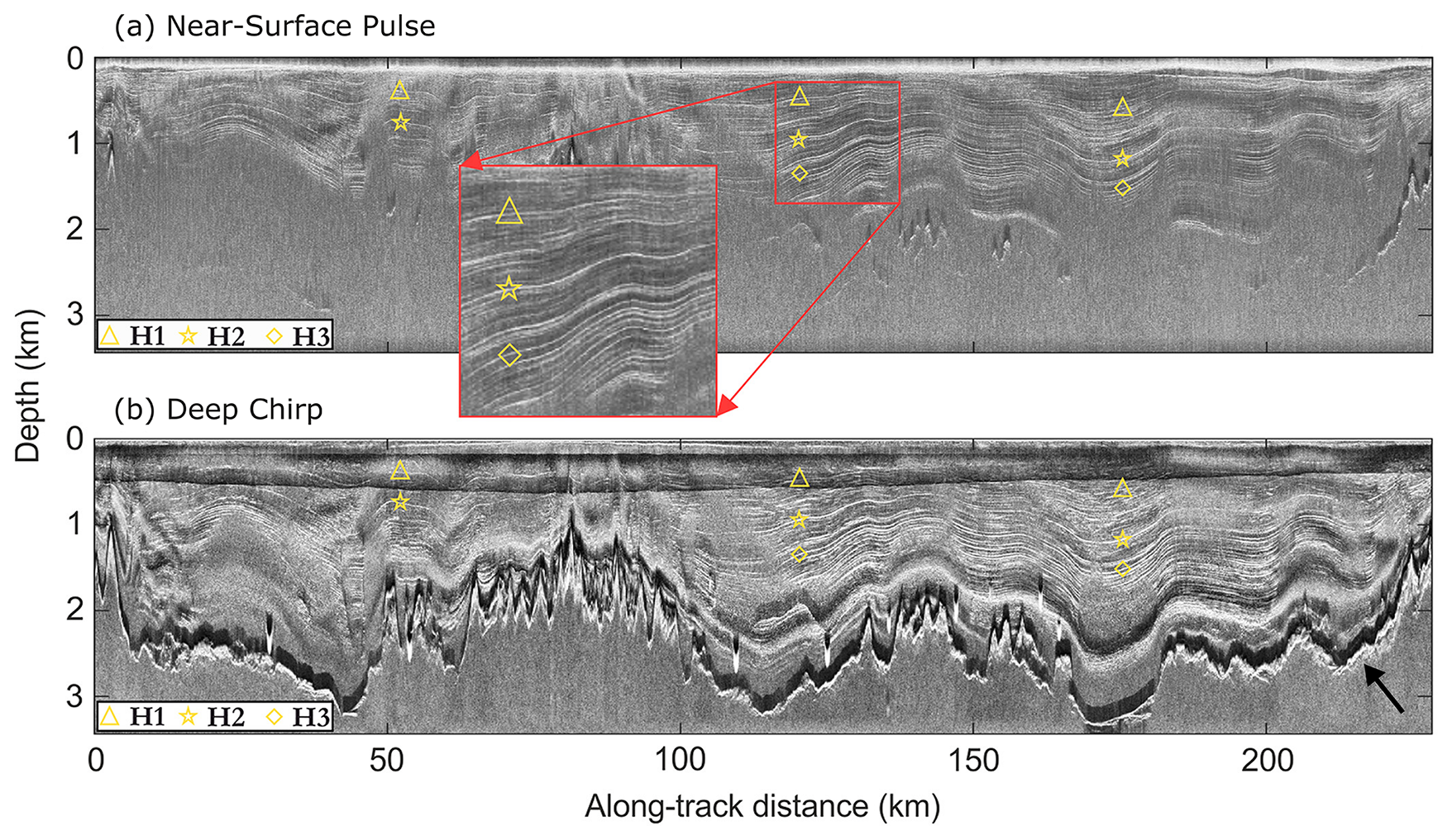
Figure 2Radargrams from Institute Ice Stream, West Antarctica, obtained by the British Antarctic Survey PASIN RES system in (a) pulse (shallow-sounding) and (b) chirp (deep-sounding) radar modes (Frémand et al., 2022), vertically differentiated to accentuate fine detail. Symbols highlight three IRHs widely found across West Antarctica in airborne radar data. The bed reflection (black–white interface) is partially visible in (a) and clearly visible in (b), marked by the black arrow. Figure modified from Ashmore et al. (2020).
In the upper and middle part of the ice column, radiostratigraphy typically arises from (a) density variations as snow compacts into ice (as explained in pioneering work by Robin et al., 1969, and Clough, 1977) and (b) variations in electrical conductivity as volcanic aerosols present in the air during snow deposition are incorporated into the firn (Hammer, 1980; Millar, 1981; Millar, 1982). These density- and electrical-conductivity-derived IRHs are related to snow and ice layers of a specific age buried under subsequent snow accumulation and, thus, may be considered to be isochronous (Hempel et al., 2000; Eisen et al., 2006). Such RES-imaged isochrones may often represent composites of multiple real horizons in the ice, and their thickness is dependent on the RES system resolution (Harrison, 1973; Winter et al., 2017). They are often traceable for considerable distances in RES profiles: some IRHs in the Antarctic and Greenland ice sheets are continuous for hundreds or even thousands of kilometres (e.g. MacGregor et al., 2015a; Winter et al., 2019a; Ashmore et al., 2020). For the focus of this review, isochronous reflections arising from density and electrical conductivity are of significant interest, and IRHs that can be dated at ice cores and traced continuously over long distances to form a “dated radiostratigraphy” are particularly valuable (as explored in depth in Sects. 4 and 5). There are, however, some cases, especially in the lower part of the ice column, where diachronous IRHs (i.e. IRHs that cannot be treated as single time markers) may be visualised in radargrams. The most common examples of such are IRHs that are thought to manifest sudden changes in the ice-crystal orientation fabric that cause anisotropic radio wave propagation or cold–warm ice transitions where the pore space on the warm side is filled with meltwater instead of air (Harrison, 1973; Fujita et al., 1999; Eisen et al., 2007). Over ice shelves, pervasive IRHs can mark the boundary between atmospherically derived (meteoric) and subglacially accreted or submarine-accreted (marine) ice (Holland et al., 2009; Das et al., 2020).
The specular behaviour of IRHs also positions them as ideal targets for repeated observations of vertical velocity over time, directly tracking the deformation of the ice sheet via static phase-sensitive repeat measurements at a point (typically using an autonomous phase-sensitive radio-echo sounder or ApRES; Nicholls et al., 2015) or via airborne re-flights of transects with coherent RES systems (Castelletti et al., 2021). Although these methods have been practised in recent field campaigns (e.g. Hills et al., 2022; Chung et al., 2023; Fudge et al., 2023), we do not discuss this aspect of radiostratigraphy further in this review beyond noting that establishing the distribution of appropriate IRHs could be a valuable component in expedition planning. A review of static techniques can be found in Kingslake et al. (2014), while repeat-pass airborne interferometry of IRHs is an active field of research (Castelletti et al., 2021).
While the imaging and analysis of radiostratigraphy and its application to assessing ice-sheet evolution form the main focus of this paper, other significant features of internal architecture also convey information that can be used to help understand current and past ice-sheet processes (as depicted in Fig. 1). These include basal units, which exhibit different dielectric properties compared to the surrounding ice and may result from ice folding due to contrasts in material properties; accretion; melting due to high rates of geothermal heat flux or overburden pressure from the ice above; or freeze-on processes taking place at the base of the ice sheet (Bell et al., 2011; Bell et al., 2014; Bons et al., 2016; Leysinger Vieli et al., 2018; Wrona et al., 2018; Ross et al., 2020; Franke et al., 2023b). Additionally, buried near-surface and basal crevassing imaged by RES systems may be indicative of past grounding-line evolution or ice-stream stagnation events (Retzlaff et al., 1993; Matsuoka et al., 2009; Catania et al., 2010; Kingslake et al., 2018; Wearing and Kingslake, 2019). We elaborate further on these other significant features of internal architecture in Sect. 5.5.
The information available from radargrams (e.g. Fig. 2) and the degree to which the internal architecture can be used for different applications depend firstly on the settings of the RES system acquiring the data and secondly on choices made in processing the data. Below, we summarise the typical processing workflow for radargram generation and highlight key decisions that influence the interpretation of the resulting radiostratigraphy. Figure 3 presents a conceptual support for this discussion. We then discuss the different methods used to trace radiostratigraphy through radargrams and to assign dates to key IRHs.
3.1 Data processing for optimising IRH tracing
RES data acquisition (Fig. 3a) can be categorised broadly based on two criteria: (a) phase control of the transmitter or phase sampling by the receiver (i.e. coherent vs. incoherent) and (b) the nature of the transmitted wave (pulsed versus chirped; Gogineni et al., 1998; Peters et al., 2005). Processing (depicted in Fig. 3b) is similar for all systems, and so, here, we highlight differences that affect radargram quality. Direct measurements of the dielectric properties of ice cores show that ice conductivity varies on much smaller length scales than what can be imaged by RES (Harrison, 1973; Eisen et al., 2003). Therefore, each RES system represents subsurface reflectors differently, and data acquired from the same area but by different RES systems may show different IRHs on intersecting radargrams due to the differences in RES imaging capabilities (see Fig. 4, after Winter et al., 2017, for an example of a comparison between different RES systems). For pulsed systems, processing cannot improve the vertical resolution, which is controlled by the bandwidth and the rate of sampling of the received waveform. For chirped systems, the waveform must be fully sampled first and then match-filtered, integrating the received power while also finely resolving radiostratigraphy targets based on the chirp's bandwidth (Hélière et al., 2007; Peters et al., 2007). This “pulse compression” is the first step in producing a radargram from a chirped system.
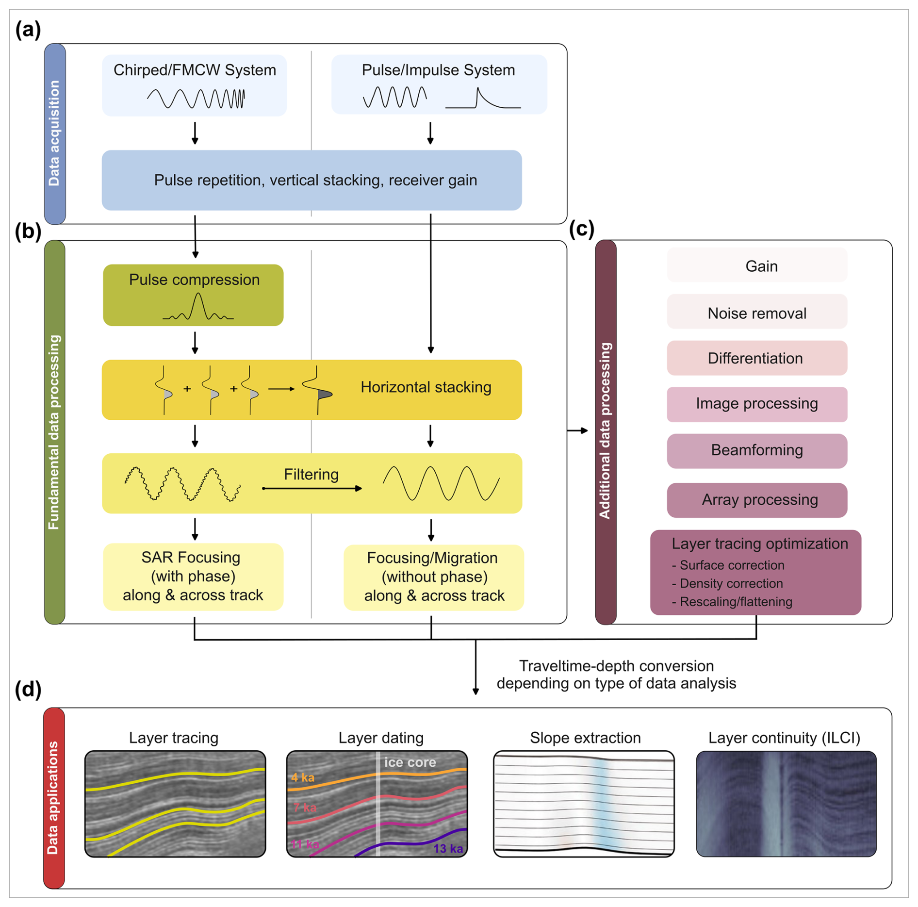
Figure 3Flowchart illustrating key steps for the processing of RES data from chirp and pulse systems for subsequent radiostratigraphic analysis. (a) Basic configurations and parameters defined based on data acquisition. (b) Fundamental and (c) additional steps commonly taken when processing data to visualise IRHs. (d) Depiction of some common ways of tracing or otherwise quantifying IRH geometry.
Following initial data acquisition, RES data are typically processed using geophysical techniques of varying sophistication (Fig. 3b). For example, incoherent noise is typically reduced by various forms of horizontal averaging, and bandpass filtering can remove irrelevant components of the measured signal. Finally, if possible, the data should be focused or migrated to reposition the received signal energy as precisely as possible to their true subsurface locations. This can be done via several methods: (a) incoherent echo summation, often termed “migration”, as in reflection seismology (Yilmaz, 2001); (b) synthetic aperture radar (SAR) focusing for point scatterers, common in satellite applications (Ulaby and Lang, 2015); or (c) application of algorithms designed specifically for RES of specular reflections (Heister and Scheiber, 2018; Castelletti et al., 2019; Xu et al., 2022). SAR focusing has a proven ability to reduce image artefacts and to improve along-track resolution, especially in areas with steeply sloping radiostratigraphy (Holschuh et al., 2014; Castelletti et al., 2019). Multiple SAR-processing techniques currently exist for coherent RES systems, including (a) unfocused SAR (short apertures without phase correction and equivalent in name to Doppler filtering or coherent echo summation; Hélière et al., 2007) or (b) more advanced focused SAR using either 1-D correlations resulting in intermediate apertures or 2-D correlations resulting in longer apertures (Peters et al., 2005; Peters et al., 2007). The latter is the processing of choice for modern coherent systems for the detection of IRHs in areas with steeply dipping reflections. Unfocused and 1-D SAR approaches will emphasise flat specular reflectors and reduce clutter at the cost of dipping specular horizons. Large SAR apertures are critical for tracking steeply dipping IRHs but present greater computational costs and an overall reduction in the signal-to-noise ratio. Cross-track antenna arrays can allow for the determination of cross-track IRH slopes.
A series of additional corrections and image-processing steps can also be taken to optimise RES data for tracing radiostratigraphy (Fig. 3c). For radar data acquired by airborne platforms, the space from the aircraft to the ice surface on the radargram must be removed to obtain true depths below the ice surface; this is often conducted by shifting the vertical axis of the radargram to time zero for each RES trace and flattening the surface based on the location of the surface reflection on the radargram. This can be done by using data from the altimeter and/or lidar on board the aircraft, by using high-resolution surface DEMs, or by using the picked surface reflection from the radargram itself (e.g. MacGregor et al., 2015a). Localised density corrections, based on ground-truthing measurements in the upper section of ice cores or other geophysical measurements (e.g. radar data acquired by airborne platforms; Eisen et al., 2002), may also be applied to convert the two-way-travel time from the RES data to ice-equivalent depths. Alternatively, for depth-correcting RES below the pore close-off depth, a spatially uniform firn depth correction that is typically of the order of several metres may be used to obtain ice-equivalent depths (e.g. Ashmore et al., 2020), although this assumption may only be valid in dry and stable parts of the ice sheet and not in highly dynamic regions (Dowdeswell and Evans, 2004). Others have also vertically rescaled (or flattened) RES data to facilitate the tracing of continuous reflections by semi-automatic pickers (e.g. Fahnestock et al., 2001b; Sect. 3.2; MacGregor et al., 2015a, 2025). Finally, specific image-processing filters can also be applied to enhance the gain and reduce incoherent noise, which can facilitate IRH tracing based on RES data (Ashmore et al., 2020; Bodart et al., 2021; Wang et al., 2023; Franke et al., 2025).
Importantly, for users interested in tracing IRHs and, especially, the deepest IRHs, most RES data over Antarctica, including those available from open-access repositories, are not optimised for detecting radiostratigraphy. Typically, the data have been acquired and processed to optimise retrieval of the bed echo, and some datasets require considerable reprocessing from the raw data to improve the clarity of the radiostratigraphy between the ice surface and the bed (Castelletti et al., 2019). In particular, for thick or unusually heterogenous ice, the best strategy is often to experiment with filtering data differently at different depths until the IRHs at selected depths are most clearly visualised.
3.2 Tracing radiostratigraphy
The primary method for extracting internal architecture from radargrams (e.g. Fig. 3d) has been to trace or “pick” IRHs, typically using semi-automated techniques (e.g. Cavitte et al., 2016; Koch et al., 2024). Where radargram quality is high, IRHs are easily traced and continuous, and fully automated methods may also perform well (e.g. Panton, 2014; Xiong et al., 2018; Delf et al., 2020). Machine-learning methods are in their infancy but show promise for more rapidly tracing radiostratigraphy, as demonstrated recently by Moqadam et al. (2025) on deep IRHs. However, so far, most successful applications have been limited to near-surface IRHs in the upper few tens of metres of the ice column (e.g. Dong et al., 2021; Rahnemoonfar et al., 2021; Yari et al., 2021), primarily due to the lack of vertical disturbances and low noise in surface-conformable IRHs. Thus, for most radargrams and deep-ice applications, semi-automated tracing of IRHs is still required. This relies on algorithms that typically follow the local maxima in return power between adjacent traces within a predetermined vertical window using either open-source or commercial and bespoke software from the seismic industry (e.g. Winter et al., 2019a; Ashmore et al., 2020; Chung et al., 2023; Sanderson et al., 2024). A comprehensive overview of IRH-tracing methods is provided by Moqadam and Eisen (2025).
The process of tracing IRHs can be categorised into two approaches: (a) tracing as many IRHs as possible regardless of their amplitudes or continuity (MacGregor et al., 2015a, 2025) or, more commonly, (b) identifying IRHs that have a high echo power, appear distinguishably brighter than adjacent IRHs on radargrams and are continuous for long distances (> 100 km), using crossovers between intersecting RES profiles to ensure reliability in the tracing process (e.g. Cavitte et al., 2016; Winter et al., 2019a; Ashmore et al., 2020; Bodart et al., 2021; Wang et al., 2023).
Importantly, the thickness of a given IRH in a radargram is dependent on the range resolution of the RES system used to image it, such that RES systems with a high pulse width and, thus, a finer vertical resolution may detect several thinner IRHs that would otherwise appear as a single, broader reflection in coarser-resolution systems (see Fig. 4 and Harrison, 1973; Millar, 1982; Karlsson et al., 2014; Winter et al., 2017; Bodart et al., 2021; Cavitte et al., 2021; Franke et al., 2025). This must be accounted for when comparing the position and aspect of IRHs traced in data from RES systems operating with different frequencies and system characteristics (Winter et al., 2017; Franke et al., 2025).
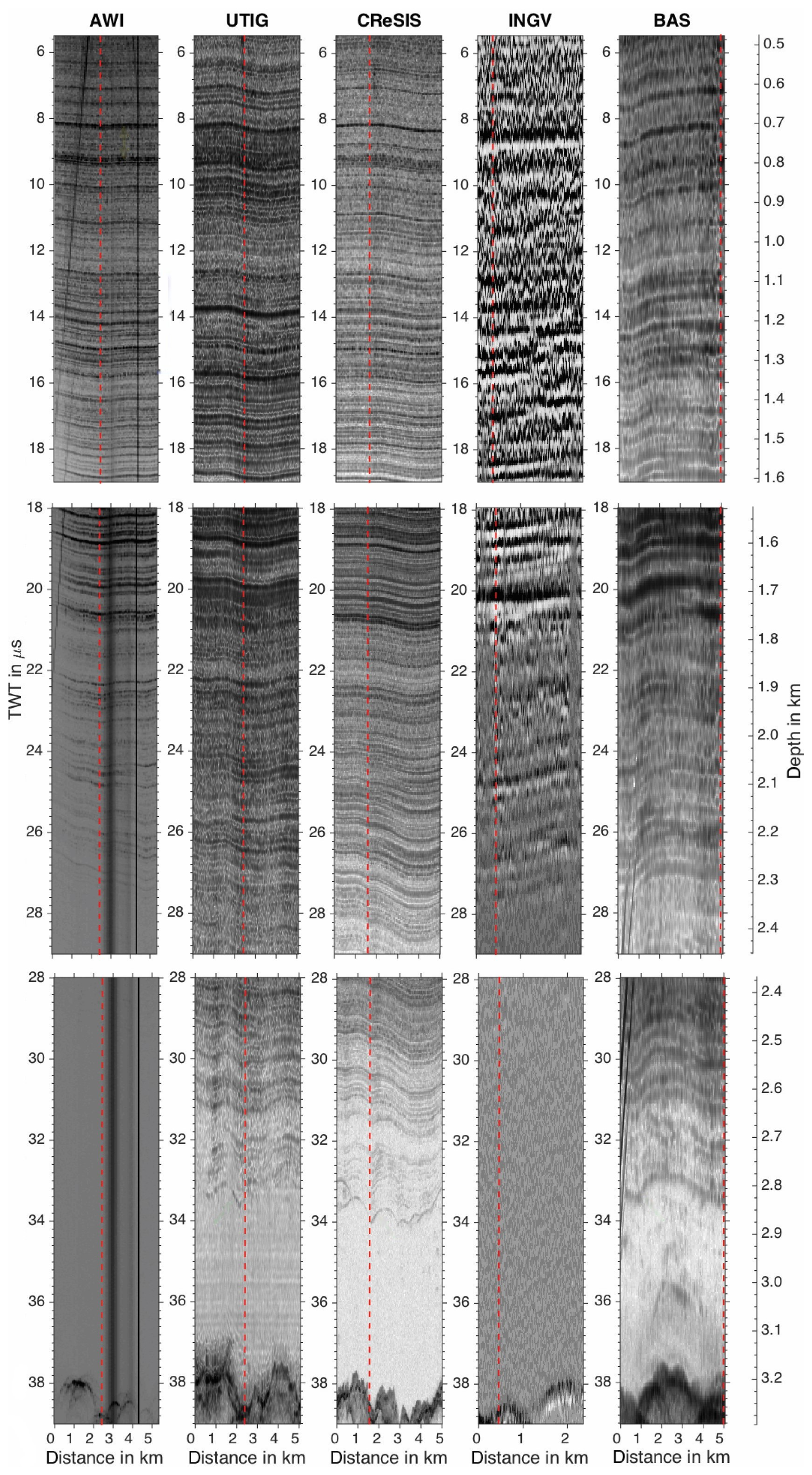
Figure 4RES profiles of a few kilometres in length for five RES systems that have profiled across or near Dome C (location in Fig. 6d). The vertical red line in each profile marks the position of the trace closest to Dome C. The surface reflections are shifted to time zero, and the length of the RES profiles is indicated on the horizontal axes. For the bottom UTIG and CReSIS panels, a 2-D-focused processing is applied. The RES data were acquired with the following: (1) AWI 150 MHz Aero-EMR, (2) UTIG 60 MHz HiCARS, (3) CReSIS 194 MHz MCoRDS, (4) Italian National Institute of Geophysics and Volcanology (INGV) 150 MHz RES system, and (5) BAS 150 MHz PASIN. For full details and the original figure from which this is modified, see Winter et al. (2017).
3.3 Complementary approaches to tracing IRHs for characterising radiostratigraphy
Even having applied all possible data-processing strategies described above, radiostratigraphy may remain challenging or impossible to trace over some regions due to the innate physical properties of ice in such areas. For example, IRHs may become warped or buckled or disrupted by differential ice flow or flow over steep topography (e.g. Siegert et al., 2003b; Ross et al., 2011; Bingham et al., 2015; Franke et al., 2023a; Jansen et al., 2024), while unconformities can be introduced by significant wind scouring of the ice surface (e.g. Welch and Jacobel, 2005; Luo et al., 2022). This variability in itself provides important information about past and present ice behaviour (as we explore further in Sect. 5) and, hence, warrants alternate methods to characterise the radiostratigraphy where IRHs cannot readily be traced.
One method for assessing the general variability of radiostratigraphy across large regions of ice sheets is the Internal Layering Continuity Index (ILCI) developed by Karlsson et al. (2012). This tool maps the variability in vertical signal strength for individual RES traces, acting as a relative measure of the number of dielectric contrasts compared to the signal-to-noise ratio. High ILCI values typically indicate regions of an ice sheet characterised by multiple, traceable IRHs, while low ILCI values tend to indicate regions of an ice sheet with disrupted or discontinuous IRHs or regions with very few or no IRHs detected by the RES system. Although the method is not easily transferable between different RES systems due to acquisition and processing differences, the ILCI has been extensively applied to several regions in both Antarctica (Fig. 5) and Greenland as a mechanism for rapidly identifying the specific sub-regions in which IRHs are likely to be traceable (e.g. Sime et al., 2014; Bingham et al., 2015; Karlsson et al., 2018; Frémand et al., 2022; Tang et al., 2022; Sanderson et al., 2023).
Alternative methods have focused on the extraction of IRH slopes. This avenue acknowledges the challenges in tracing and dating radiostratigraphy in areas of fast or complex ice flow or where the acquisition or processing methods that have been used were not tailored to the recovery of radiostratigraphy. For discontinuous radiostratigraphy, local slope information is valuable because radiostratigraphic slope is closely related to particle trajectories within the ice sheet (Hindmarsh et al., 2006; Parrenin and Hindmarsh, 2007; Ng and King, 2011; Holschuh et al., 2017). Several methods have therefore been developed to extract slope information, such as incoherent averaging methods (Sime et al., 2011; Holschuh et al., 2017; Delf et al., 2020) and methods that use along-track phase information during SAR processing to estimate IRH slope (MacGregor et al., 2015a; Castelletti et al., 2019; Oraschewski et al., 2024).
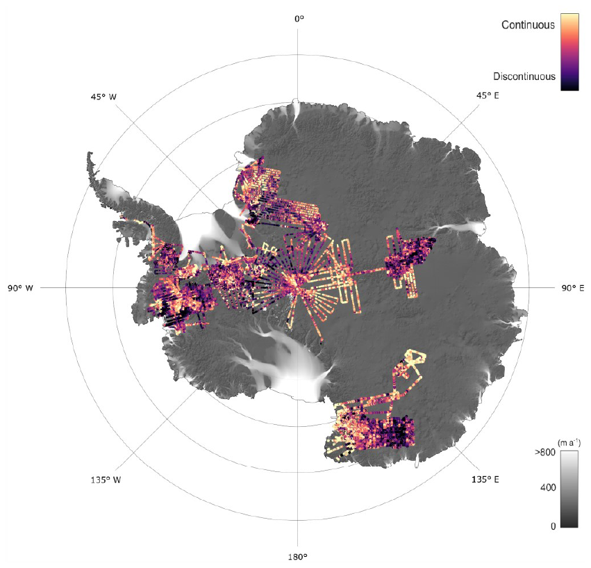
Figure 5Radiostratigraphic continuity (ILCI) calculated over 10 airborne RES datasets acquired by BAS. Continuous and readily traceable IRHs are indicated in the slow-flowing regions of the ice sheet (high ILCI; bright yellow), whereas disrupted or absent IRHs are likely in the faster-flowing sections of ice streams or where subglacial topography is highly variable (low ILCI; dark purple). The background maps show ice-flow velocities from MEaSUREs (Rignot et al., 2017) and a hillshade of the bedrock from BedMachine (Morlighem, 2020). Figure modified from Frémand et al. (2022).
3.4 Dating internal-reflection horizons (isochrones)
As introduced in Sect. 2, most RES-imaged IRHs have been shown to be isochronous, and the majority of those we treat in this review (i.e. that are imaged in between approximately the first and last few hundreds of metres of the ice column) arise due to the RES system imaging variations in the electrical conductivity (i.e. acidic content) of the ice with depth. Hereafter in this paper, reiterating that most IRHs are isochrones, we will use the term isochrones to refer to IRHs and will only re-use the term IRH where it may be ambiguous with regard to whether IRHs are isochronous.
Ages can be assigned to isochrones at intersections with deep ice cores where age–depth models have already been derived from chemistry analyses (e.g. McConnell et al., 2017; Cole-Dai et al., 2021; Bouchet et al., 2023), but, where this is not possible, modelling techniques can also be used. Before any age can be assigned, the age uncertainty that arises from the RES system itself must first be assessed. Uncertainty in reflector depth arises from several sources: (a) proximity of the RES profile to the ice-core site (otherwise, a specific reflector geometry (typically flat) must be assumed between the point of closest approach and the ice-core site) (MacGregor et al., 2015a); (b) the radio wave speed, which varies based on permittivity variations as a function of englacial density and anisotropy (e.g. Kovacs et al., 1995; Fujita et al., 1998); (c) the range resolution of the RES system and the signal-to-noise ratio of each traced reflection at (or near) the ice-core site, which enable an estimate of the depth precision at which each traced reflection can be known (e.g. Cavitte et al., 2016); (d) the uncertainty associated with the use of a firn correction, which typically comes from errors in the depth–density curve at ice-core sites (e.g. Cavitte et al., 2016); and (e) the picking accuracy of both the ice surface and the isochrones themselves, which can add several metres of uncertainty. This latter point may include the uncertainty arising from the source of the surface product (i.e. either from the centimetre resolution onboard altimeter or lidar or directly from the RES data, which have a much lower resolution of the order of several metres) and from the fact of whether the picking algorithm is tailored to extract the onset of the reflection, the half-amplitude or the peak value. The total reflector depth uncertainty is the root-sum-square combination of the uncertainties above.
The ideal scenario for assigning ages to isochrones is that a RES profile intersects or passes sufficiently close (∼ 500 m vicinity) to the location of an ice-core site for the ice core's depth–age scale (from chemical profiling or layer counting) to be useable for directly assigning ages to the RES-imaged isochrones. In such cases, direct dating at the ice core can be done in two ways: (1) direct age matching by comparing the isochrone depth from the RES to the age–depth scale of the ice core (e.g. MacGregor et al., 2015a; Cavitte et al., 2016; Bodart et al., 2021) or (2) by matching observed RES isochrones to simulated RES isochrones based on the measured dielectric profiling at the ice core (e.g. Eisen et al., 2003; Winter et al., 2017; Franke et al., 2025). The former can be applied to any isochrones but results in larger uncertainties due to the conversion of the two-way-travel time from the RES data to ice-equivalent depths, whereas the latter is more accurate as the conductivity peaks represent the true physical origin of the isochrones. However, the condition that a reflection must rise above the background noise of the RES system limits its application to specific isochrones (Franke et al., 2025). For either case, the isochrone-depth uncertainty can then be combined with the ice-core age uncertainty as a root-sum-square error to assign a total age uncertainty to the mapped reflections; in these cases, uncertainty is generally dominated by the ice-core-derived age uncertainty in the upper third of the ice column, while the RES-derived depth uncertainty increasingly dominates at larger depths (e.g. MacGregor et al., 2015a; Cavitte et al., 2016; Muldoon et al., 2018; Winter et al., 2019a; Wang et al., 2023). More recently, some isochrones have been dated not by their direct intersection with an ice core but rather by intersecting other RES datasets that, in turn, have already been dated by their intersection with a distant ice core. As a result, the age–depth profile is transferred to the new dataset at the crossover(s) between the intersecting RES datasets (e.g. Ashmore et al., 2020; Bodart et al., 2021). In these cases, the relative uncertainties of the different RES systems at the intersections between RES datasets additionally need be factored into the final age estimation, and the final age estimates are commonly checked using the modelling techniques introduced next (e.g. Bodart et al., 2021; Sanderson et al., 2024).
Where isochrones cannot be directly correlated to an ice-core age–depth relationship due to a lack of nearby ice cores, any intersections with previously dated isochrones or missing sections in the record (e.g. due to disrupted englacial stratigraphy), age–depth modelling is required to assign ages to isochrones. This is typically done using 1-D models in stable parts of the ice sheet such as at ice divides (e.g. Nye, 1957; Dansgaard and Johnsen, 1969; Ashmore et al., 2020; Bodart et al., 2021; Sanderson et al., 2024) or using more complex multi-dimensional (2-D or 3-D) models in areas with challenging ice-flow or bed conditions (e.g. Waddington et al., 2007; MacGregor et al., 2015a; Parrenin et al., 2017; Lilien et al., 2021).
RES data have been acquired across Antarctica covering 6 decades. An impression of the history can be gained from the periodic release of maps of subglacial topography, with the first being by Drewry (1975) and Drewry (1983; Antarctica Glaciological and Geophysical Folio Sheet 9), and then through the Bedmap series, now in its third iteration (Frémand et al., 2023, their Fig. 1; Pritchard et al., 2025). However, those maps and associated papers focus only on where the RES data were used to pick an echo at the bed and do not provide information on whether the constituent surveys also imaged internal architecture. Therefore, here, we will outline the sequential development of airborne RES systems and surveys across Antarctica, focussing on their attributes and availability for imaging and analysing internal architecture (Sect. 4.1). We will then briefly introduce some wide-ranging ground-based RES surveys that complement the overall database available for interrogating internal architecture (Sect. 4.2) and conclude with a “progress report” of existing traced radiostratigraphy across Antarctica (Sect. 4.3).
4.1 Evolution and availability of airborne RES for internal architecture
Airborne RES surveying across Antarctica has undergone three key technology-led developments as follows. Firstly, there has been a transition from initially recording RES data onto analogue tape recorders or film to inputting data directly into more sophisticated digital recording systems. Secondly, there has been the introduction of Global Navigation Satellite Systems (GNSSs) to onboard flight navigation. Thirdly, there has been a progression from all datasets being acquired incoherently, wherein RES data receipt and recording were not phase-matched, to RES acquisition with coherent RES systems, for which the phase of the transmitted signal is preserved in a reference signal with which the received signal is compared, greatly increasing the clarity and quality of the imaging, which is especially pertinent for the analysis of internal architecture. The following subsections and Fig. 6 describe what may accordingly be termed as the three main eras of airborne RES surveying over the Antarctic ice sheets.
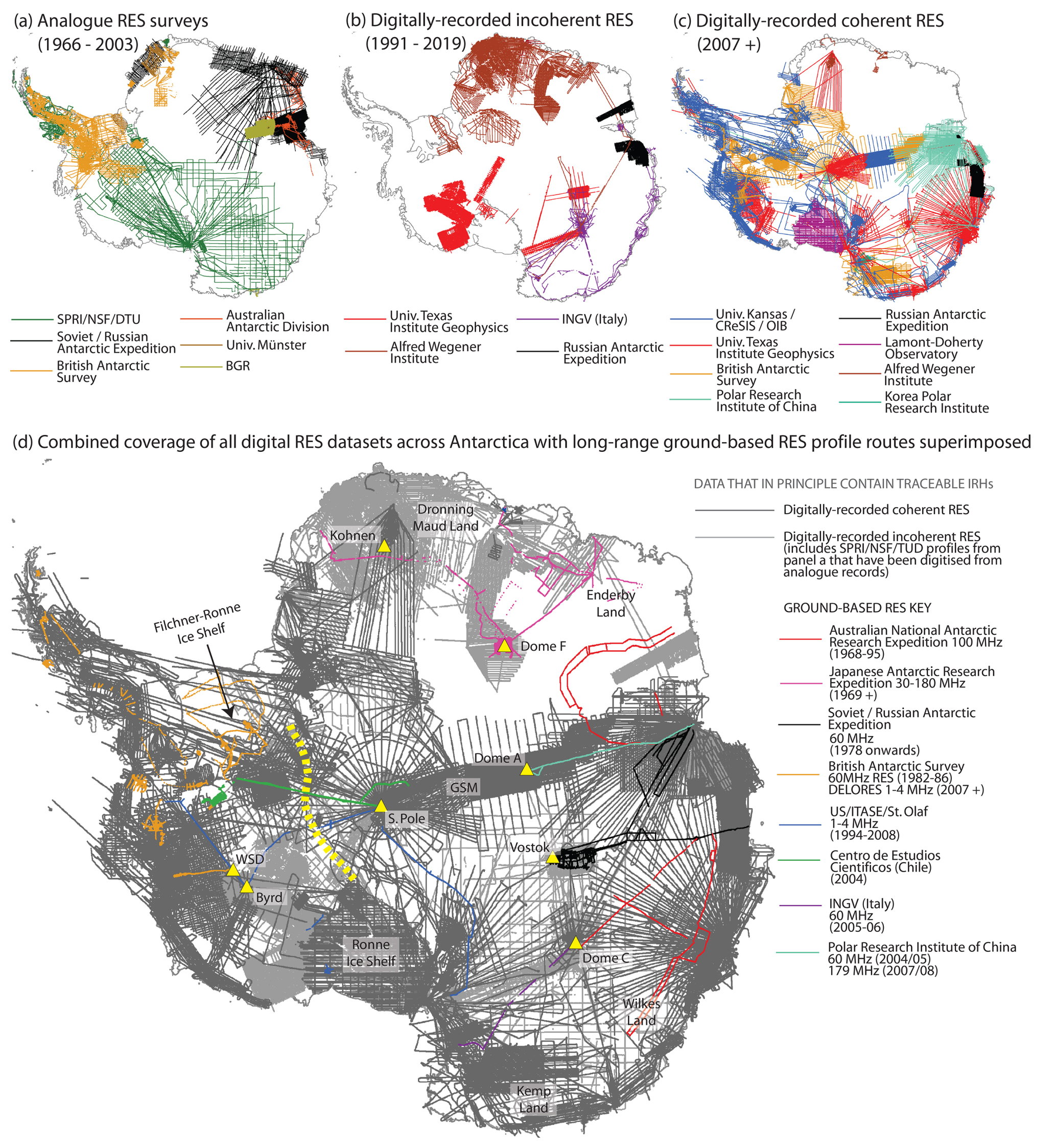
Figure 6RES coverage and suitability for tracing internal architecture across Antarctica. (a) Airborne RES profiles acquired with analogue RES systems between 1966 and 2003. SPRI/NSF/DTU denotes Scott Polar Research Institute/National Science Foundation/Technical University of Denmark, and BGR denotes Bundesanstalt für Geowissenschaften und Rohstoffe (Germany's Federal Institute for Geosciences and Natural Resources). (b) Airborne RES profiles acquired digitally but incoherently between 1991 and 2019. INGV denotes Istituto Nazionale di Geofisica e Vulcanologia (Italy's National Institute of Geophysics and Volcanology). (c) Airborne RES profiles acquired digitally and coherently since 2007. Univ. Kansas/CReSIS/OIB denotes data acquired using systems designed by the University of Kansas, often under the auspices of the USA's Centre for Remote Sensing and Integrated Systems and/or NASA's Operation IceBridge. (d) Map of all digitally acquired airborne RES profiles (two shades of grey) and long-range ground-based RES profiles (coloured tracks) that collectively represent all data presently available for analysing internal architecture throughout Antarctica. The coverage of digitally recorded incoherent RES (light grey) includes the originally analogue but now digitised SPRI/NSF/TUD data collected between 1971 and 1974. RES profile locations depicted in this map are from Frémand et al. (2023, their Tables S1 and S2). US/ITASE/St. Olaf denotes data acquired by radar system and operators from St. Olaf College, USA, often under the auspices of the International Trans-Antarctic Expedition (Mayewski et al., 2005). Also annotated in panel (d) are key locations mentioned in this paper, with yellow triangles marking key deep-ice-core sites. The dashed yellow line marks the nominal divide between the West Antarctic and East Antarctic ice sheets.
4.1.1 Analogue data recording
Before the 2000s, the majority of airborne RES data across Antarctica were recorded onto analogue tape recorders or film, and most of these data, including all data acquired prior to the 1990s, were acquired without GNSSs being available for accurate navigation. Due to the analogue recording, all such systems recorded data incoherently. The coverage of these analogue surveys is shown in Fig. 6a.
Continent-spanning RES surveying was pioneered across West Antarctica and around half of East Antarctica by the UK-based Scott Polar Research Institute (SPRI), with key logistical support from the USA's National Science Foundation and, from 1971, using antennas designed and installed by engineers from the Technical University of Denmark (DTU), which fundamentally improved the reflection of IRHs (Swithinbank, 1969; Evans and Smith, 1970; Gudmandsen et al., 1975; Drewry, 2023). Also, throughout the late 1960s and 1970s and continuing through the 1980s, the Soviet Antarctic Expedition conducted airborne surveying across parts of East Antarctica (Popov, 2020) (Fig. 6a). Both the SPRI/NSF/DTU and Soviet campaigns used a 60 MHz centre frequency RES system, inspiring the British Antarctic Survey (BAS) to adopt the same centre frequency as it commenced with progressive regional RES surveys throughout the 1980s (Fig. 6a).
The 1990s saw a step-change improvement in flight navigation and concomitant RES dataset positioning with the introduction of GNSSs. The 1990s was also a period of transition, with some RES operators developing the capacity to acquire data digitally and coherently (as expanded upon in Sect. 4.1.2 and 4.1.3), but other major data providers, such as the British Antarctic Survey and Russian (formerly Soviet) groups, continued to record data only in analogue format and, hence, also incoherently. These analogue surveys, supplemented by some regional surveys across East Antarctica over the same era by groups from Australia (e.g. Morgan et al., 1982) and Germany (e.g. Thyssen and Grosfeld, 1988; Damaske and McLean, 2005), are depicted in Fig. 6a.
4.1.2 Digital data recording, incoherent RES
Digital recording systems were first implemented in Antarctic airborne RES surveying in the early 1990s by the USA-based University of Texas Institute of Geophysics (UTIG). The UTIG's surveys throughout the 1990s, principally of West Antarctica, used adapted versions of the 60 MHz SPRI/NSF/DTU incoherent RES system (Blankenship et al., 2001; Carter et al., 2007; Young et al., 2016). In the mid-1990s, national operators from Germany and Italy also commenced digital acquisition of incoherent RES surveys across parts of East Antarctica, with both using RES systems operating around a higher centre frequency of 150 MHz (Steinhage et al., 2001; Eisen et al., 2007; Tabacco et al., 2008; Zirizzotti et al., 2008). The full coverage of airborne RES data acquired digitally with incoherent RES systems is depicted in Fig. 6b. This includes data acquired broadly from the early 1990s to the mid-2000s, although some operators continued to acquire data incoherently into the mid-2010s.
4.1.3 Digital data recording, coherent RES
Fully coherent RES systems were first operated in Antarctica by the USA-based University of Kansas on a joint USA (NASA; National Aeronautics and Space Administration)–Chile (CECs; Centro de Estudios Cientifícos) mission to survey fast-changing regions of West Antarctica (Rignot et al., 2004). In 2005, Kansas became host to the USA's Center for Remote Sensing and Integrated Systems (previously Center for Remote Sensing of Ice Sheets; CReSIS), an NSF-designated National Science and Technology Centre with a focus on ice-sheet sounding, and began to operate an upgraded series of deep-looking RES systems with centre frequencies of ∼ 190–194 MHz named the Multichannel Coherent Radar Depth Sounders (MCoRDS), which were deployed widely across Antarctica between 2009 and 2019 as part of NASA's Operation IceBridge programme (Fig. 6c; Rodriguez-Morales et al., 2013; MacGregor et al., 2021).
From 2004 onwards, both BAS and UTIG transitioned their RES systems into coherent data acquisition, with this year also marking BAS' first implementation of digital data recording. BAS' Polarimetric Radar Airborne Science Instrument (PASIN) has a centre frequency of 150 MHz and transmits two waveforms, namely a narrow pulse (0.1 µs) for detecting shallow radiostratigraphy in the upper 2 km of the ice column and a deep-sounding chirp (4 µs) for detecting deeper radiostratigraphy and the bed (Corr et al., 2007; Hélière et al., 2007; see Fig. 2 for examples of each). PASIN was upgraded in the mid-2010s to enable the acquisition of swaths (i.e. wide strips) of RES data to map the ice-sheet bed (Arenas-Pingarrón et al., 2023). UTIG integrated a coherent 60 MHz centre frequency RES system (Moussessian et al., 2000) with radio frequency hardware from DTU to allow for high-power coherent recording, which enabled synthetic aperture radar (SAR) processing of acquired data (Peters et al., 2005; Peters et al., 2007; refer back to Sect. 3.1 for a description of the SAR processing). This initial High-Capability Radar Sounder (HiCARS) system was translated into commercially available components (HiCARSII) which were incorporated from the mid-2010s into the subsequent Multifrequency Airborne Radar-sounder for Full-phase Assessment (MARFA), capable of cross-track interferometry for clutter discrimination (Blankenship et al., 2017; Castelletti et al., 2017; Scanlan et al., 2020).
Other airborne RES operators transitioned into coherent RES across Antarctica during the mid-2010s. Alongside continuing surveying by BAS, CReSIS and UTIG, large volumes of coherent RES data have been acquired across Antarctica over the last decade by the Russian Antarctic Expedition (Popov, 2020; Popov, 2022), by Germany's AWI using an improved version of CReSIS' MCoRDS system (Humbert et al., 2018; Karlsson et al., 2018; Winter et al., 2019a; Wang et al., 2023; Franke et al., 2025), and by the Polar Research Institute of China (PRIC; Cui et al., 2020a, b, c) and the Korean Polar Research Institute (KOPRI; Lindzey et al., 2020; Lee et al., 2021) (Fig. 6c).
4.2 Ground-based RES datasets
Since the 1960s, groups from at least 12 institutions have acquired ground-based RES datasets focused on sounding Antarctica's subglacial bed and have also typically imaged internal architecture in the process. Typically, ground-based surveys have been confined to smaller regions or shorter profiles than those covered by the airborne RES surveys, befitting the more common application of ground-based RES to detailed site surveys in preparation for retrieving ice cores or for accessing the ice bed or subglacial lakes (e.g. Frezzotti et al., 2004; Laird et al., 2010; Christianson et al., 2012; Ross and Siegert, 2020). From these surveys, several local radiostratigraphies have been published (e.g. Eisen et al., 2005; Jacobel and Welch, 2005; Koutnik et al., 2016; Cavitte et al., 2023; Chung et al., 2023). These detailed studies provide invaluable seeding points for extending radiostratigraphies much more widely across the ice sheets (e.g. Winter et al., 2019a) and for understanding better ice-sheet history and glaciological processes.
Supplementing the more local surveys, some ground-based profiles have been acquired over traverses of multiple hundreds of kilometres over the Antarctic ice sheets, and these traverses, marked in Fig. 6d, merit special attention as potential resources for analysing pan-continental radiostratigraphy. A particularly extensive programme of ground-based surveys has been conducted since 1969 by the Japanese Antarctic Research Expedition (JARE), connecting coastal East Antarctica in Dronning Maud and Enderby Land to Dome F, with data from some of the traverses conducted in the 1990s underpinning seminal work on the origins of IRHs (Fujita et al., 1999; Matsuoka et al., 2003). Today, data from JARE represent some of the most spatially extensive of Antarctica's ground-based RES datasets and constitute a rich repository of internal architecture (Fujita et al., 2011; Van Liefferinge et al., 2021; Tsutaki et al., 2022). Further long ground-based RES traverses were conducted by several national and international teams in the 2000s under the auspices of the International Trans-Antarctic Scientific Expedition (ITASE). RES profiles containing particularly rich internal architecture were acquired by the USA-NSF's ITASE traverses across both West (Welch and Jacobel, 2003; Jacobel and Welch, 2005) and East Antarctica (Welch et al., 2009), with findings by Arcone et al. (2012a) suggesting that, in some parts of East Antarctica, the radiostratigraphy is unconformable and may present significant challenges to tracking radiostratigraphy.
4.3 Progress report
4.3.1 Summary of available data
Figure 6d shows the coverage of RES profiles acquired across Antarctica that are, in principle, available for developing a pan-Antarctic stratigraphy. This includes all RES data acquired digitally, whether coherent or incoherent. Generally, RES data that are acquired coherently are the highest quality for tracing unbroken IRHs over long distances, but incoherent data can also be utilised for IRH tracing. Figure 6d therefore also only includes data that were acquired by GNSS navigation, with one exception: the 1970s SPRI/NSF/DTU data are included because they imaged IRHs across Antarctica with a clarity that rivals many modern RES surveys and form potentially vital links across otherwise unsurveyed regions and, consequently, have been “revived” by a dedicated fine-resolution digitisation and distribution programme (Schroeder et al., 2019; Schroeder et al., 2022). Navigational uncertainties inherent to pre-GNSS navigation remain with these data (of the order of several kilometres), but there is a prospect of using crossovers with more modern datasets to reconstruct the navigation with improved accuracy (Teisberg and Schroeder, 2023).
4.3.2 Existing dated radiostratigraphy across Antarctica
Prior to the inception of AntArchitecture in 2018, several studies produced radiostratigraphies covering the last 17.5 kyr across West Antarctica and the last 352 kyr for East Antarctica (e.g. Hodgkins et al., 2000; Siegert and Hodgkins, 2000; Siegert, 2003; Siegert and Payne, 2004; Jacobel and Welch, 2005; Leysinger Vieli et al., 2011; Steinhage et al., 2013; Karlsson et al., 2014; Wang et al., 2016). However, the spatial extents of these radiostratigraphies were relatively limited. Through AntArchitecture, a more coordinated and focused approach to characterising Antarctic radiostratigraphy has been conducted, as depicted in Fig. 7 and detailed in Table 1. This programme has facilitated the recovery and characterisation of several isochrones with ages of up to 25 ka across much of the Amundsen and Weddell Sea sectors of West Antarctica (Muldoon et al., 2018; Ashmore et al., 2020; Bodart et al., 2021; Bodart et al., 2023). Over East Antarctica, a much older record has been extracted, owing to the more stable and slow-flowing ice conditions in the area, including isochrones dating back to the last 705 kyr (Cavitte et al., 2016; Winter et al., 2019a; Beem et al., 2021; Cavitte et al., 2021; Chung et al., 2023; Wang et al., 2023; Sanderson et al., 2024; Franke et al., 2025; Yan et al., 2025).
Table 1Inventory of expansive radiostratigraphic datasets for the Antarctic ice sheets, ordered by the region (EAIS, East Antarctic Ice Sheet, and WAIS, West Antarctic Ice Sheet) and cumulative distance of the dataset (here, cumulative distance corresponds to the total kilometres of the IRH profiles summed for each IRH where the data are openly available or the approximated value where datasets are not publicly available). The datasets that are openly available (via the use of a DOI) are shown in Fig. 7; locations of the ice cores are marked in Fig. 6. Data provider acronyms are provided at the foot of the table; in most cases, here, we also list a specific project acronym for each survey which can be cross-referenced through the reference and/or dataset listed in each row.
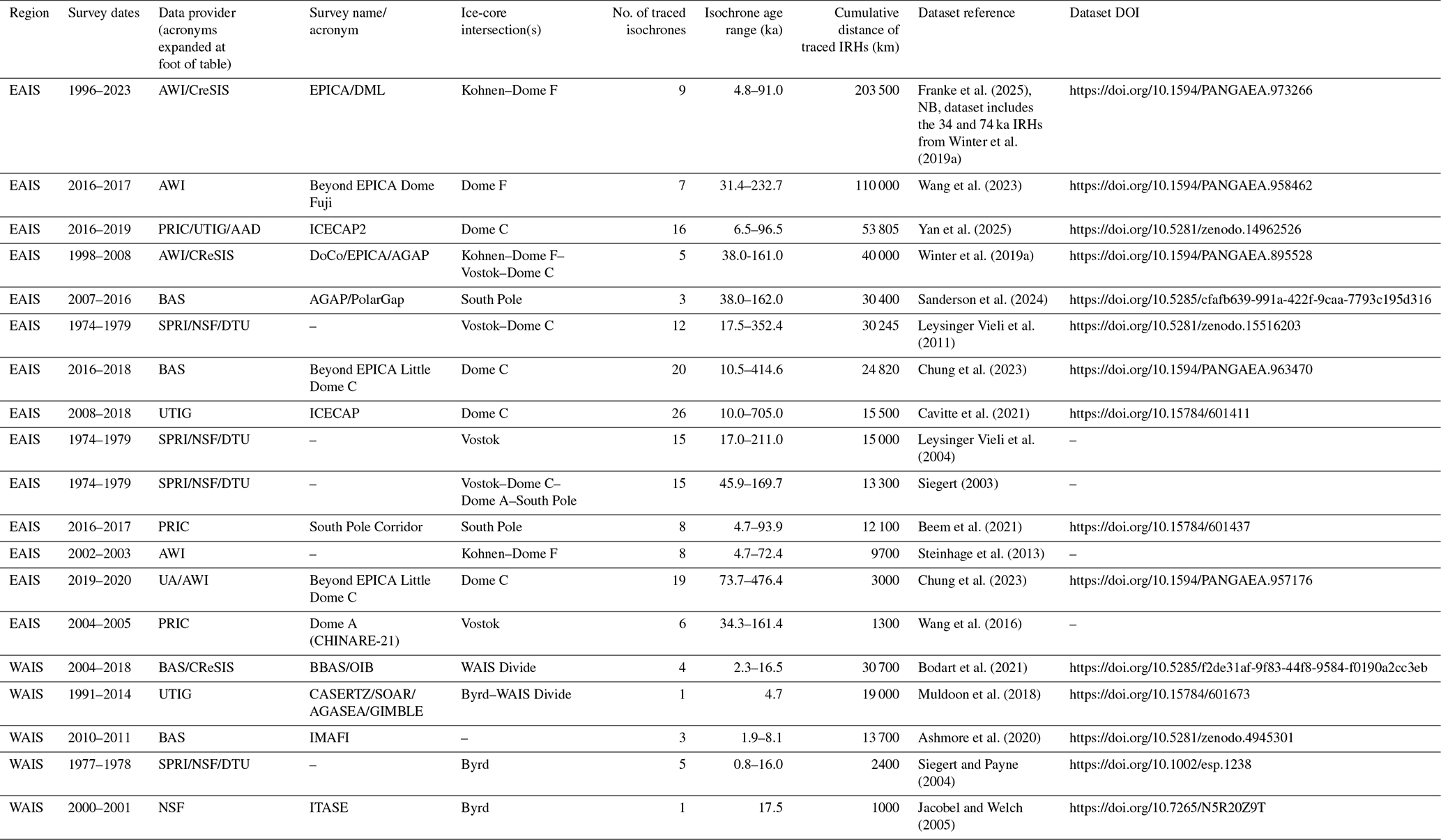
Data providers: AAD – Australian Antarctic Division; AWI – Alfred-Wegener Institute, Germany; BAS – British Antarctic Survey, UK; CReSIS – Centre for Remote Sensing and Integrated Systems, USA; NSF – National Science Foundation, USA; PRIC – Polar Research Institute of China; SPRI/NSF/DTU – Scott Polar Research Institute/National Science Foundation/Technical University of Denmark; UA – University of Alabama, USA; and UTIG – University of Texas Institute of Geophysics, USA.
A notable finding is the presence of widespread and ubiquitous isochrones that have been imaged by different RES systems and that are found in several ice-core records. Across West Antarctica, the most prevalent isochrone, dated precisely and independently at the Byrd and WAIS (West Antarctic Ice Sheet) Divide ice cores to ∼ 4.7 ka, has been identified by several studies (Jacobel and Welch, 2005; Karlsson et al., 2014; Holschuh et al., 2018; Muldoon et al., 2018; Ashmore et al., 2020; Bodart et al., 2021, 2023, Franke et al., 2025). There is evidence that this same isochrone may also be found widely across East Antarctica based on sulfate concentrations in ice cores and findings from individual RES surveys across the region (Steinhage et al., 2013; Winski et al., 2019; Beem et al., 2021; Cole-Dai et al., 2021; Sigl et al., 2022). Additionally, across much of the West Antarctic Ice Sheet, an isochrone dated to 17.5 ka (in more recent studies re-dated to 16.5 ±0.79 ka) has been observed in both ground-based and airborne RES data (Jacobel and Welch, 2005; Muldoon et al., 2018; Bodart et al., 2021). This 17.5 ka RES isochrone has been identified and linked to an eruption from West Antarctica's Mount Takahe in both the Byrd (Hammer et al., 1997) and WAIS Divide (McConnell et al., 2017) ice cores. Over East Antarctica, packages of closely spaced isochrones of ages ∼ 38, ∼ 73, ∼ 128, ∼ 160 and ∼ 170 ka have been traced from ice cores (Leysinger Vieli et al., 2011; Winter et al., 2019a; Cavitte et al., 2021; Wang et al., 2023; Sanderson et al., 2024; Franke et al., 2025); notably, the ∼ 73 ka isochrone has been linked by ice-core profiling to the Toba Eruption in Indonesia (Svensson et al., 2013). Together, such distinct isochrones, imaged by and from multiple RES systems and platforms, provide important regional or continental time markers, equivalent to Greenland's highly recognisable “three sisters” (Fahnestock et al., 2001b; MacGregor et al., 2015a, 2025), for inferring past changes at specific time intervals.
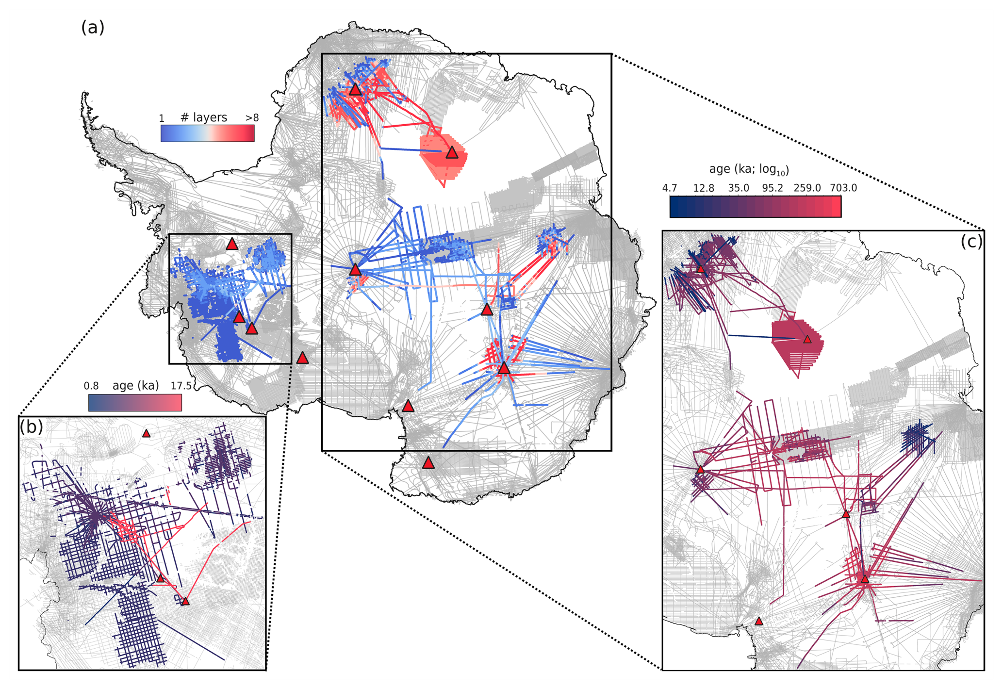
Figure 7Existing open-access dated stratigraphies across Antarctica obtained from the Digital Object Identifiers (DOIs) provided in Table 1, with RES profiles for Bedmap-2 and Bedmap-3 products shown in the background (grey; Frémand et al., 2023). Existing deep ice cores (defined here as ice cores that have been drilled to near the ice-bed interface and that provide a multi-millennial record) are shown as red triangles. (a) Maximum number of isochrones traced through each dataset (from 1 to > 8); see Table 1 for full details. (b–c) Age of the deepest (oldest) isochrone across each dataset for the West Antarctic Ice Sheet (WAIS) (b) and the East Antarctic Ice Sheet (EAIS) (c) regions, respectively. Note that the scale used for (c) is logarithmic.
Despite the advances discussed here, the established radiostratigraphy across the Antarctic ice sheets currently represents only a small subset of the total available RES data (Fig. 7; refer back to Sect. 4.3 and Fig. 6). The establishment of the AntArchitecture community and its commitment to establishing protocols for sharing and processing internal architecture across the multiple datasets are expected to facilitate further isochrone tracing, which will, in turn, contribute to the development of the first three-dimensional age–depth model of the ice sheet.
Here, we now review for what scientific purposes internal architecture has already been exploited. Section 5.1 to 5.4, supported by Fig. 8, exemplify four primary applications of RES-imaged isochrones, Sect. 5.5 explores the scientific applications of other forms of internal architecture, and Sect. 5.6 discusses how radiostratigraphic data have been incorporated into numerical modelling and their use in calibrating ice-sheet models of varying complexity. This section contextualises Sect. 6, which suggests priorities for future research that will be enabled as Antarctica's internal architecture – and, particularly, its radiostratigraphy – continues to be explored and made available.
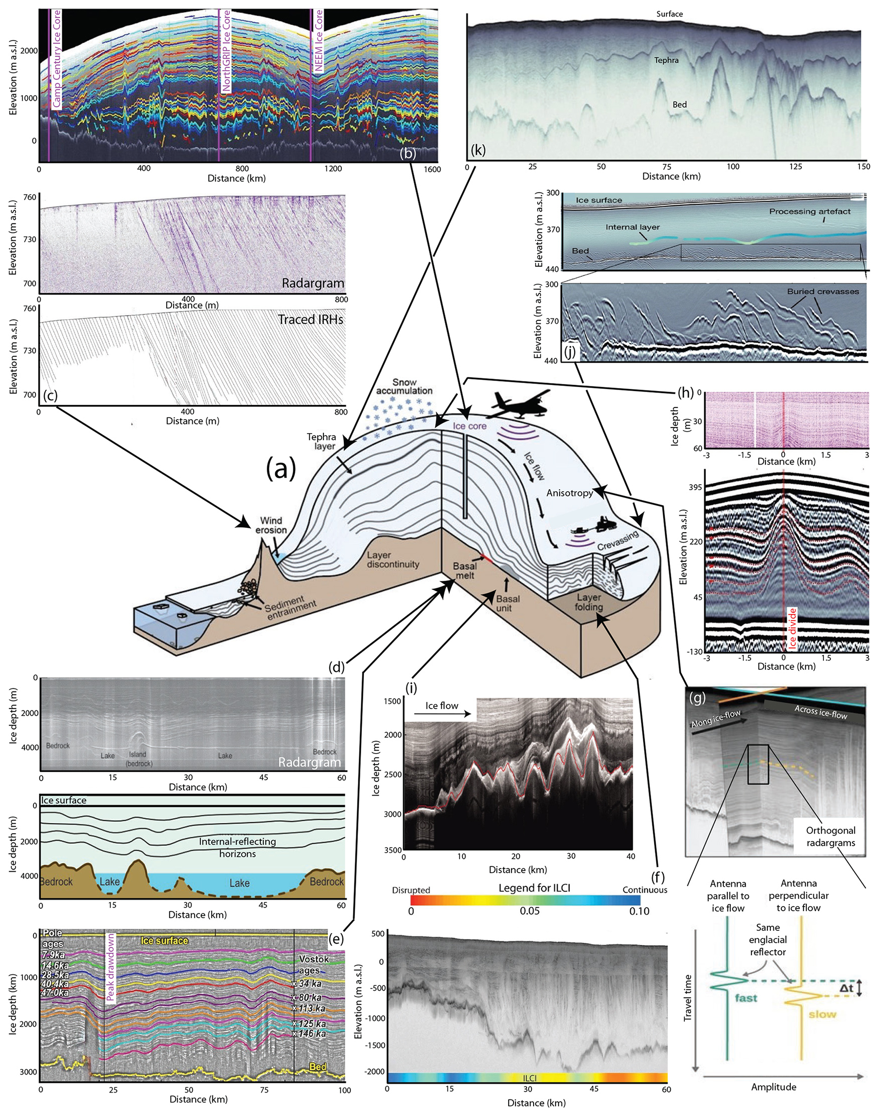
Figure 8Schematic illustration of radiostratigraphic observations within an ice sheet and their scientific applications; panel (a) in the centre depicts typical ice-sheet locations for the applications shown in subsequent panels. (b) Connecting and validating ice cores in Greenland (after MacGregor et al., 2015a). (c) Imaging intersections of IRHs with ice surface in the region of surface wind scouring (after Winter et al., 2016). (d) Using isochrones to calculate basal melting across Subglacial Lake Vostok (after Siegert et al., 2001). (e) Using isochrone drawdown to locate region of elevated geothermal heat flux near the South Pole (after Jordan et al., 2018). (f) Application of the Internal Layering Continuity Index (ILCI) to quantify disruption (folding or warping) to otherwise continuous isochrones (after Bingham et al., 2015). (g) Using intersecting RES profiles to explore ice anisotropy (after Gerber et al., 2023). (h) Raymond Arch imaged in near-surface (top panel) and deep RES across Derwael Ice Rise, Dronning Maud Land (after Drews et al., 2015). (i) Basal-ice units and suggested accreted basal ice in East Antarctica (after Bell et al., 2011). (j) Basal crevasses imaged in West Antarctica and used to date re-grounding of previously floating ice (after Kingslake et al., 2018). (k) Prominent tephra horizon imaged by RES across Pine Island Glacier, West Antarctica (after Corr and Vaughan, 2008).
5.1 Radiostratigraphy and ice cores
Ice cores from Antarctica provide fundamental palaeoclimate records (e.g. EPICA Community Members, 2004; WAIS Divide Project Members, 2015). The layering found in ice cores is also visible in radiostratigraphy as a function of the RES system resolution (Sect. 2), and we have already introduced the concept that RES records tied to existing ice cores provide a basis for extending these “point-source” age–depth chronologies into 3-D age–depth fields that extend widely across the Antarctic ice sheets (see Sects. 3.4 and 4.3.2). Conversely, RES-imaged radiostratigraphy can be used to guide researchers regarding the best locations for recovering future ice cores. Accumulation rate, ice dynamics and age–depth relationships extracted from isochrones have previously informed the appropriateness of coring sites (e.g. Neumann et al., 2008; Parrenin et al., 2017; Beem et al., 2021; Wang et al., 2023) and have been essential for pre-site surveys of potential future ice coring, e.g. for the Oldest Ice endeavour of the International Partnerships for Ice Core Sciences (IPICS; e.g. Fischer et al., 2013; Van Liefferinge and Pattyn, 2013; Karlsson et al., 2018; Lilien et al., 2021; Chung et al., 2023).
Radiostratigraphy has also provided opportunities for synchronising and reducing uncertainties in ice-core chronologies by facilitating the direct tracing of isochrones between two or more ice cores in order to correlate ice-core chronologies (as achieved for the Greenland Ice Sheet by MacGregor et al., 2015a; see Fig. 8b). In Antarctica, previous studies that have used isochrones to correlate chronologies between ice cores include Siegert et al. (1998), Steinhage et al. (2013), Cavitte et al. (2016), Le Meur et al. (2018), Winter et al. (2019a), and Sanderson et al. (2024) for East Antarctica and Muldoon et al. (2018) for West Antarctica. These studies have provided confidence that ice cores obtained from locations separate by hundreds of kilometres capture analogous variations in palaeoclimate at regional scales and that the signals recorded by RES correspond to genuine physical variations in the ice (typically variations in electrical conductivity, often related to fallout from past volcanic eruptions, as noted in Sect. 4.3.2).
The key challenge in synchronising ice-core records between distant sites using RES has been in resolving the radiostratigraphically derived and ice-core-derived chronologies between each ice-core site, given the order-of-magnitude difference in terms of the resolution of chronologies recoverable from RES (on the order of metres) versus ice-core records (on the order of centimetres). This has typically been dealt with using forward modelling based on electrical-conductivity measurements or dielectric profiling of the ice cores to provide a transfer function (e.g. Miners et al., 1997; Hempel et al., 2000; Eisen et al., 2003, 2006; Winter et al., 2017; Mojtabavi et al., 2022) or by adopting Bayesian frameworks which provide a probability distribution of the age of the isochrones (Muldoon et al., 2018). Thus, while the age–depth fields compiled from isochrones will never match the precision and accuracy of ice-core age–depth relationships (MacGregor et al., 2015a; Winter et al., 2017), they provide the spatial context that “point-source” ice cores cannot. Through isochrone constraint modelling (see Sect. 5.6), the age of the ice and its spatial distribution can be more effectively constrained in regions distant from the current drilling sites (Born and Robinson, 2021; Sutter et al., 2021).
In marginal locations of the ice sheets or around nunataks, where persistent pronounced surface scouring is co-located with upward ice flow over subglacial topography, i.e. in regions of so-called “blue ice”, very old ice may outcrop obliquely to the ice surface and hence allow the recovery of a “horizontal ice core” along the ice surface (Spaulding et al., 2013). Dated isochrones have been used to trace the age–depth model recovered from horizontal ice cores back into the ice sheet (Reeh et al., 2002; Siegert et al., 2003a; Winter et al., 2016; Fogwill et al., 2017; Baggenstos et al., 2018; see Fig. 8c). However, shearing and folding can disrupt the stratigraphic order of the outcropping IRHs, rendering the interpretation of their radiostratigraphy more complex than for most vertical ice cores.
5.2 Surface mass balance
Successive snowfall events create a record of progressively buried isochrones which can be observed in radargrams. In slow-flowing ice and, especially, around ice divides, the depth of isochrones is largely controlled by surface mass balance, and, therefore, dated radiostratigraphy has made it possible to reconstruct past surface mass balance over millennial timescales across spatially extensive regions (e.g. Nereson et al., 2000; Siegert, 2003; Siegert and Payne, 2004; Eisen et al., 2005; Waddington et al., 2007; Neumann et al., 2008; MacGregor et al., 2009; Leysinger Vieli et al., 2011; Karlsson et al., 2014; Koutnik et al., 2016; Cavitte et al., 2018; Bodart et al., 2023). Such records have fundamentally informed us about how mass balance has changed with time over past millenia, showing that, for example, accumulation rates changed significantly over central (Siegert and Payne, 2004; Neumann et al., 2008; Koutnik et al., 2016; Bodart et al., 2023) and coastal (Karlsson et al., 2014) West Antarctica throughout the Holocene. Typically, vertical strain rates must be corrected for the whole ice column, particularly in regions of (present or past) fast flow, or there is a need to account for basal processes such as enhanced basal melting (e.g. Leysinger Vieli et al., 2011; Chung et al., 2023) because, in such cases, the isochrone depths will be dynamically modified and therefore will not represent the surface mass balance at the time of deposition (e.g. Koutnik et al., 2016). Where the radiostratigraphy has not been impacted significantly by strain, the shallow-layer approximation can be applied, which allows us to ignore these strain rate corrections (Waddington et al., 2007). If horizontal advection influences the stratigraphy, 2-D, 2.5-D or 3-D modelling is required (see Sect. 5.6).
Regions with unconformable radiostratigraphy occurring throughout the ice column in parts of Antarctica have partly limited the extent to which some surface mass balance records could be more widely extrapolated (Arcone et al., 2012b; Cavitte et al., 2016). RES surveys of the upper ∼ 100 m of the ice column in the affected regions typically reveal widespread conformal, annual horizons modified by local variations in accumulation or ice flow (Eisen, 2008), and the majority of them have been ascribed to wind scouring out surface deposits and forming “megadunes” (Das et al., 2013; Traversa et al., 2023) that then become progressively buried as sets of unconformable IRHs. Studies have identified such unconformities in several locations in East Antarctica (Welch and Jacobel, 2005; Traversa et al., 2023) and West Antarctica (Woodward and King, 2009; Holschuh et al., 2018).
5.3 Basal melting and geothermal heat flux
The presence of a subglacial waterbody or enhanced geothermal heat flux draws isochrones down towards the ice base. Exploiting this principle, isochrones have been used to calculate melting at the base of the ice. Mismatches between surface-accumulation-driven modelled isochrones and traced isochrones have been used to infer regions of enhanced basal melting in Greenland (Dahl-Jensen et al., 1997; Fahnestock et al., 2001a) and Antarctica (Carter et al., 2009; Yan et al., 2025) on the principle that removal of ice at the base by basal melting thins annual layers above. However, for locating areas of enhanced geothermal heat flux (or subglacial lakes, which may sometimes owe their existence to enhanced geothermal heat flux), researchers now typically rely more on analysing the reflectivity or specularity of the ice-bed echo in RES data (e.g. Young et al., 2016; Chu et al., 2021) and only use isochrones to guide derivations of basal melting where such more direct data are lacking.
Isochrones have been analysed in more detail over parts of Antarctica to constrain basal melting in more localised settings. For example, Siegert et al. (2000) used deviations in the dip of deep isochrones away from parallelism with the ice-bed and/or subglacial-lake surface over Subglacial Lake Vostok to calculate basal melting and water exchange between the lake and the overlying ice sheet (Fig. 8d). Jordan et al. (2018) identified isochrones dipping towards the bed ∼ 200 km from the South Pole (Fig. 8e) and used these to model how much basal melt would be required to draw the isochrones down towards the bed. By assuming that minimal frictional melting would be generated by the slow ice flow in this region, they showed that the most likely cause of the isochrones being drawn down towards the bed must be enhanced geothermal heat flux in this region. Ross and Siegert (2020) undertook a detailed survey of isochrone geometry over Subglacial Lake Ellsworth, West Antarctica, and showed that the isochrones were preferentially drawn down over the northwestern shoreline of the lake rather than the lake itself. This conclusion was in agreement with the pattern of basal mass balance derived from previous numerical modelling of water circulation in the lake and indicated very high basal melting of ∼ 16 cm a−1 on its northern shoreline.
5.4 Ice-flow dynamics
Moving ice causes IRHs that were originally deposited flat at the surface to deform through folding, tilting and disruption. Therefore, deformed isochrones may be analysed to interpret past ice-flow dynamics. Present-day (last ∼ 35 years) information on ice-flow dynamics is derived from satellite monitoring of ice-surface flow (Rignot et al., 2017), but to understand fully where and how ice-flow dynamics have changed over the last several thousand years and, hence, how they may be likely to do so again, researchers have interrogated how changes in ice-flow dynamics have been imprinted into the RES-imaged internal architecture. The most common methodology has been to explore and classify where the radiostratigraphy diverges from relatively flat isochrones to profiles that show folding (a.k.a. buckling, warping or disruption) of the isochrones (Fig. 8f). Wherever there is folding of isochrones, it is an indication that the ice has experienced considerable strain, often as a result of flowing around or over significant bedrock obstacles (Robin and Millar, 1982; Hindmarsh et al., 2006; Tang et al., 2022) or becoming variously stretched and compressed as it flows through an ice-stream onset region or through ice-stream shear margins (Jacobel et al., 1993; Bell et al., 1998; Ng and Conway, 2004; King, 2011). Overall, isochrone folding can indicate convergent ice flow, anisotropic rheology, basal freeze-on, basal sliding, non-negligible transverse velocity gradients or the abutting of units of contrasting rheology. Importantly, the signature recorded by these processes is often advected downstream so that where it is observed does not necessarily indicate where the folding took place (Weertman, 1976; Jacobel et al., 1993; Leysinger Vieli et al., 2004; NEEM Community Members, 2013; Wolovick et al., 2014; Bons et al., 2016; Leysinger Vieli et al., 2018; Ross et al., 2020; Franke et al., 2021; Jennings and Hambrey, 2021; Jansen et al., 2024). In certain cases, relict folds that do not correspond to the current ice-flow direction indicate a past change in ice-flow direction (Conway et al., 2002; Siegert et al., 2004; Rippin et al., 2006; Franke et al., 2022).
Therefore, while there are multiple origins for isochrone folding, their geographical association with fast ice flow has led to their presence being used as a broad diagnostic of the long-term stability (or otherwise) of ice flow around Antarctica (e.g. Rippin et al., 2003; Siegert et al., 2003b; Bingham et al., 2007; Karlsson et al., 2009; Ross et al., 2011; Bingham et al., 2015; Winter et al., 2015; Sanderson et al., 2023). In areas where isochrones are strongly disrupted by (past or present) enhanced flow, extracting the ILCI or isochrone-slope products from the radiostratigraphy (as introduced in Sect. 3.3) has helped to complement reconstructions of past or present ice-flow dynamics (e.g. Karlsson et al., 2012; Bingham et al., 2015; Holschuh et al., 2017; Ashmore et al., 2020; Luo et al., 2020; Sanderson et al., 2023). In some cases, sequences of folded isochrones have been observed beneath sequences of conformable isochrones, indicative of a past sudden change from fast to slow ice flow (e.g. Conway et al., 2002; Siegert et al., 2013; Kingslake et al., 2016). Obtaining more complex information on past ice-dynamic changes falls into the realm of applying numerical modelling, which is taken up in Sect. 5.6.
An important outcome of most ice flow is that the ice crystals themselves develop a preferred orientation, typically termed as anisotropic crystal orientation fabric, which may then influence the direction-dependent propagation speed of radio waves through ice (Gow and Williamson, 1976; Robin and Millar, 1982; Fujita et al., 1999; Matsuoka et al., 2003; Eisen et al., 2007; Drews et al., 2012; Jordan et al., 2020, 2022). Studies have reconstructed and constrained the mechanical anisotropy of ice and histories of ice deformation by calculating the travel time difference for IRHs across intersecting RES profiles where the radio waves have been polarised in different directions (e.g. Fig. 8g; Ershadi et al., 2022; Jordan et al., 2022; Gerber et al., 2023; Zeising et al., 2023). A special case of isochrone folding due to changes in ice-crystal fabric occurs at ice divides, where upward-pointing folds termed Raymond arches (Fig. 8h) form due to the interplay of the strain rate dependence of ice viscosity, which leads to stiffer ice beneath the divide, slowing isochrone thinning down relative to the flanks (Raymond, 1983; Vaughan et al., 1999; Martín et al., 2009; Hindmarsh et al., 2011; Matsuoka et al., 2015). The special geometry of these isochrone arches has been used to infer local ice-flow history, including the onset of divide flow (Conway et al., 1999; Kingslake et al., 2016), divide migration (Nereson et al., 1998; Martín et al., 2009; Schannwell et al., 2019) and ice-thickness changes (Drews et al., 2015). With stable ice-divide positions over extended periods of time, these arches can evolve further into double-peaked Raymond arches, as observed (Drews et al., 2013) and simulated by incorporating anisotropy into the ice-flow models (Pettit et al., 2007; Martín and Gudmundsson, 2012; Martín et al., 2014). In terms of efforts to trace isochrones widely across the Antarctic ice sheets, Raymond arches have the greatest relevance in how they affect site selection for deep ice cores that are ideally used to assign ages to Antarctic-wide isochrones (as introduced in Sect. 3.4). The relative thinness of isochrones at the apex of Raymond arches implies that better-resolution age–depth records reaching further back in time would be obtained around the flanks rather than on the apexes of ice divides where arches are present.
5.5 Applications of internal architecture complementary to radiostratigraphy
Ice located near to the bed of an ice sheet is typically expected to have undergone strong deformation due to shear or to originate from processes other than earlier surface accumulation. The basal ice of Antarctica and Greenland is typically characterised by an echo-free or low-backscatter zone lacking coherent layered reflections, termed an echo-free zone (EFZ) in early observations (Drewry and Meldrum, 1978; Robin and Millar, 1982; Fujita et al., 1999). With modern RES systems, this zone now appears as a basal unit in which IRHs are often warped, folded and pinched out and consequently lack coherent reflections (Drews et al., 2009), but, even without traceable radiostratigraphy, this architecture contains useful information about ice properties and origins. With the progressive enhancement of RES system range resolution, a variety of reflection sub-units distinctly standing out from the otherwise low-backscatter zone have been identified (e.g. Fig 8i; Bell et al., 2011, 2014; Wrona et al., 2018; Ross et al., 2020; Lilien et al., 2021; Franke et al., 2024). Some of these features manifest as zones with nearly continuous high backscatter spanning several hundred metres in thickness. Some features drape over mountainous subglacial regions (e.g. in Antarctica's Gamburtsev Mountains and the Jutulstraumen drainage basin; Bell et al., 2011; Wrona et al., 2018; Franke et al., 2024), while others build plume-like structures within the cores of englacial folds (e.g. in northern Greenland and Antarctica's Institute Ice Stream; Bell et al., 2014; Ross et al., 2020). These basal units are likely to be of different origins and exhibit different dielectric properties compared to their low-backscatter surroundings, offering insights into potential formation mechanisms. Current hypotheses include strong deformation on the micro-scale by ice dynamics (Drews et al., 2009), freeze-on of subglacial water at the ice base (Bell et al., 2011; Creyts et al., 2014; Leysinger Vieli et al., 2018) and the incorporation of point reflectors (e.g. basal sediment; Winter et al., 2019b; Franke et al., 2024), as well as ice flowing over regions with changes in basal friction (Wolovick et al., 2014; Wolovick and Creyts, 2016) or convergent flow (Bons et al., 2016; Ross et al., 2020). The presence of these basal units can influence the rheological properties and fabric structure of the ice column, as well as impact the continuity of climatic records, highlighting their significance for ice-core drilling projects and ice-flow-modelling endeavours (Bell et al., 2014; MacGregor et al., 2015a; Panton and Karlsson, 2015).
Buried surface crevasses imaged in RES data have been used as key evidence for timing the shutdown of Kamb Ice Stream (Retzlaff et al., 1993; Jacobel et al., 2000; Smith et al., 2002; Catania et al., 2006) and for the reorganisation of flow through Whillans Ice Stream (Conway et al., 2002). The locations and geometry of basal crevasses formed near the grounding line (Fig. 8j) have also been used to identify previously floating ice and to time the formation of ice rises and ice-flow reorganisation during the Holocene in Antarctica's Weddell Sea sector (Kingslake et al., 2018; Wearing and Kingslake, 2019).
Finally, some particularly bright isochrones have been used to constrain the timing of past volcanic eruptions and to constrain the ranges of their tephra fallout. Most reflectors of this sort are relatively bright through chemical signatures alone (e.g. Welch and Jacobel, 2003), but a particularly prominent isochrone, ∼ 30 dB stronger than other typical isochrone reflection strengths and, thus, interpreted as containing physical tephra fragments in addition to chemical residues, was mapped and interpreted by Corr and Vaughan (2008) to demonstrate that a volcanic eruption occurred ∼ 2000 years ago in West Antarctica and covered much of the Pine Island Glacier basin (Fig. 8k).
5.6 Using isochrones in ice-sheet models
Ice-flow models of different complexities comprise the foremost tools for projecting future ice-sheet and glacier evolution (e.g. Gagliardini et al., 2013; Cornford et al., 2015; DeConto and Pollard, 2016; Seroussi et al., 2020; 2024). Incorporating radiostratigraphic data into ice-sheet models provides a means for validation, improves their calibration and might be essential for making more robust projections by models seeking to constrain ice-sheet evolution over the past few centuries to the late Quaternary (Hindmarsh et al., 2009; Leysinger Vieli et al., 2011; Holschuh et al., 2017; Born and Robinson, 2021; Sutter et al., 2021). Palaeoproxy records such as exposure age dating (Brook and Kurz, 1993; Mackintosh et al., 2014; Hillebrand et al., 2021), grounding-line reconstructions (Bentley et al., 2014; Wearing and Kingslake, 2019) or estimates of past sea-level highstands (Dutton et al., 2015) provide invaluable snapshots of ice-sheet variability on local, regional and continental scales (Lecavalier et al., 2023, present a state-of-the-art database), but their interpretation remains challenging in terms of attribution of ice volume and changes to the grounding zone and ice elevation. Dated radiostratigraphy, on the other hand, contains detailed information on the evolution of ice flow on the relevant timescales (as compiled for today in Sect. 4.3.2) and thus provides a much-refined calibration target bridging gaps in between snapshot proxy data. Although the theoretical link between ice flow and isochrone geometry has been established for the steady tube flow of an ice sheet (Parrenin and Hindmarsh, 2007), the general 3-D, transient case remains far more challenging. In this section, we present an overview of recent developments in ice-sheet modelling that incorporate or exploit isochronal data from RES surveys.
5.6.1 Modelling past climate and ice-dynamic changes
Radiostratigraphy is an ideal tuning target for ice-sheet models on continental, regional (catchment) and local scales because it inherently records the history of the ice flow, as well as its response to changing climate conditions in terms of its geometry. As opposed to traditionally employed tuning targets such as surface flow, ice-sheet geometry or ice volume, which only represent snapshots of ice-sheet evolution, radiostratigraphy provides a 3-D structure which has been formed by the transient palaeo-evolution of the ice sheet. Modelling isochronal geometry and age is technically relatively straightforward, with the main challenge being pervasive uncertainties in boundary conditions (e.g. climate forcing and geothermal heat flux) and the intrinsic uncertainties of ice-sheet models due to their parameterisations of physical processes (Sutter et al., 2021). Isochrones in RES data, age–depth profiles in ice cores and the isotopic content of ice sheets have been modelled by employing either Lagrangian (Sutter et al., 2021) or semi-Lagrangian (Tarasov and Peltier, 2003; Clarke et al., 2005; Goelles et al., 2014) advection or isochronal models (Born, 2017; Rieckh et al., 2024). Models that simulate stratigraphy can thus be used to explore the effects of palaeoclimate evolution on ice-dynamic changes, such as marine ice-sheet instabilities or the evolution of ice-sheet drainage systems.
Continental-scale ice-sheet models employing approximations of the full Stokes equations have allowed for the computation of ice flow on timescales of centuries to millions of years, albeit at the cost of resolution, which is usually ∼ 5–40 km (Pollard and DeConto, 2009; Golledge et al., 2015; Sutter et al., 2019; Albrecht et al., 2020; Seroussi et al., 2024). While these relatively coarse grid sizes (compared to applications of full Stokes models; e.g. Zhao et al., 2018) preclude a meaningful interpretation of small-scale processes that influence radiostratigraphy (e.g. local freezing, melting, bedrock features), large-scale models have the advantage of incorporating the whole thermomechanically coupled ice-sheet system and its response to changing climate conditions. Consequently, large-scale models are also the main tools for projections of sea-level contributions from the Antarctic and Greenland ice sheets (e.g. Goelzer et al., 2020; Seroussi et al., 2020, 2024).
The analysis of isochrones to inform us of past ice flow need not be limited to the grounded parts of an ice sheet and has been extended to ice shelves (Višnjević et al., 2022; Moss et al., 2025), ice rises (Goel et al., 2018, 2024) and the ice-rise–ice-shelf system (Henry et al., 2025). In these studies, isochrones have served as valuable resources for reconstructing both the surface and/or basal mass balance of ice shelves and ice rises using forward and inverse modelling along the flowline (in 2-D) and for investigating rheological properties of ice-rise–ice-shelf systems in 3-D (Henry et al., 2025). Extending this approach to include the past ice-shelf evolution and linking the isochronal structure to its grounded counterparts remain challenging due to the lack of tie points in relation to dated isochrones and a lack of observable isochronal structure across the grounding line.
5.6.2 Model integration of isochronal data
A range of models have been used to calculate the age–depth relationship in ice over both large and small portions of Antarctica and to compare this with existing radiostratigraphies, an exercise that can offer valuable insights into ice-sheet processes and how these are represented in ice-sheet models (Fig. 9). When integrating isochronal data in models, multiple factors play a role in the choice of model setup, such as the size of the area of interest (e.g. regional or continental) and the type of flow regime present (e.g. dome, vertical shearing, extension). Various types of flow regime are found in Antarctica, ranging from vertical compression at domes to vertical shear and, finally, to longitudinal extension in ice streams and ice shelves. Consequently, it is important to use a model with the most suitable dimensionality (1-D, 2-D or 3-D) for the specific glaciological conditions in the area being studied. We note that 2.5-D models, i.e. 2-D models that take into account some aspects of a third dimension, provide another option (Chung et al., 2024).
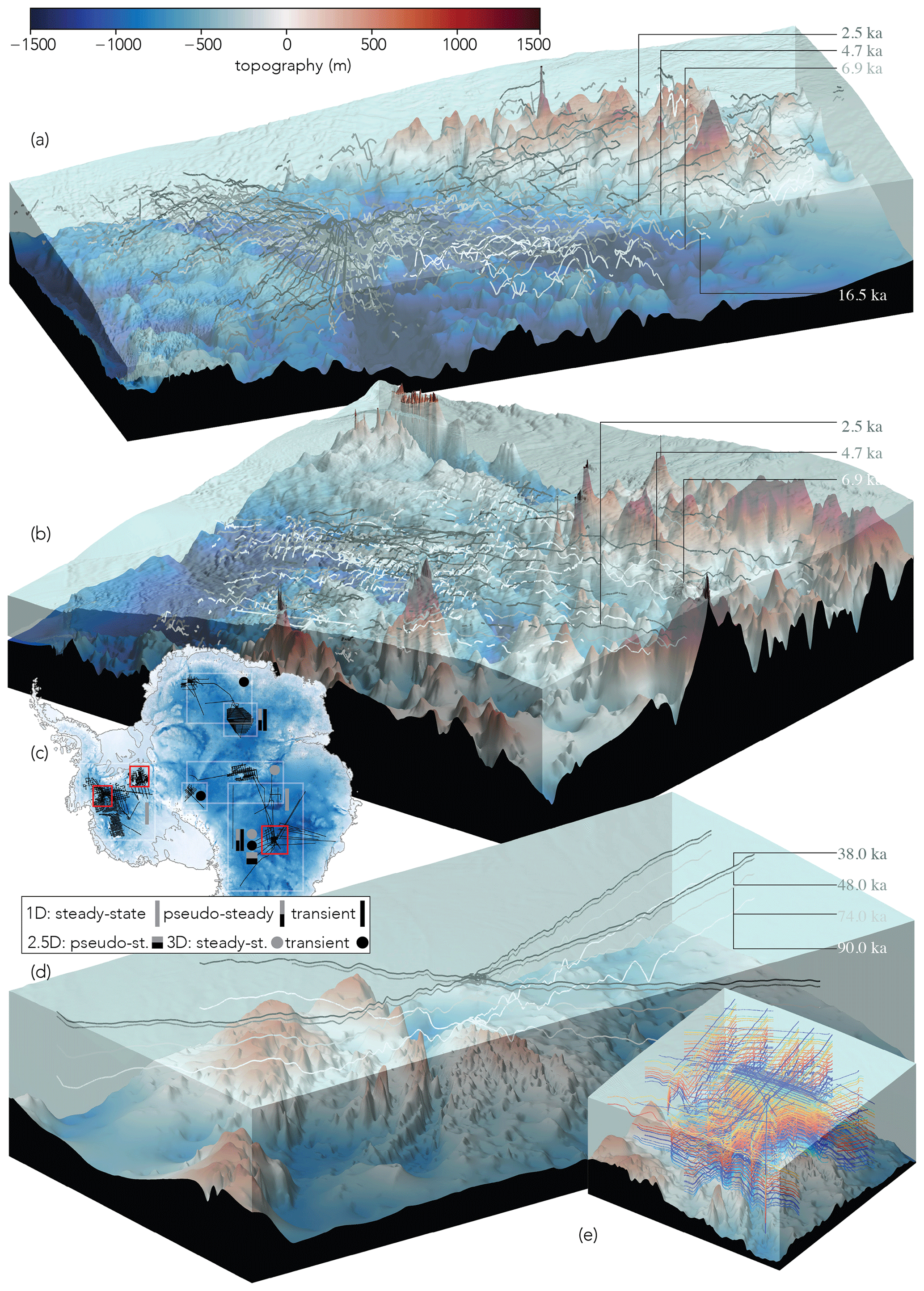
Figure 9A 3-D visualisation of selected traced and dated isochrones in East and West Antarctica and locations where different modelling applications have been conducted. Panel (a) shows 2.5, 4.7, 6.9 and 16.5 ka isochrones (greyscale lines) across the Pine Island–Thwaites Glacier catchment area (Bodart et al., 2021). Panel (b) shows 2.5, 4.7 and 6.9 ka isochrones spanning Institute Ice Stream (Ashmore et al., 2020). (c) Map of Antarctic traced and dated isochrone transects (black lines) and areas where at least one modelling study is available (grey boxes); red boxes denote areas of the 3-D visualisations. (d) Traced and dated (38, 48, 74 and 90 ka) isochronal structure around Dome C from Winter et al. (2019a) and (e) 19 isochrones (10–366 ka) from Cavitte et al. (2021).
The 1-D models typically assume negligible horizontal flow, making simplifying assumptions such as a steady-state velocity field and the local layer approximation (Waddington et al., 2007, provide guidelines on applicability) and have predominantly been used at domes such as Dome C (Parrenin et al., 2017; Lilien et al., 2021; Chung et al., 2023) and Dome F (Obase et al., 2023; Wang et al., 2023), where vertical compression dominates. Dated isochrones have been used in multiple studies to constrain 1-D age–depth models of different complexity to determine millennial-scale accumulation rates in Antarctica (e.g. Leysinger Vieli et al., 2004; Siegert and Payne, 2004; MacGregor et al., 2009; Karlsson et al., 2014; Koutnik et al., 2016; Cavitte et al., 2018; Zhao et al., 2018; Ashmore et al., 2020; Bodart et al., 2023; Sanderson et al., 2024) and to retrieve horizontal flow velocity from 2-D isochrone architecture (Eisen, 2008). While most such studies have been restricted to using a steady state due to temporal limitations in the available data, some models have allowed for temporal changes in boundary conditions (Callens et al., 2016; Parrenin et al., 2017; Chung et al., 2023).
The 3-D modelling of ice-rise stratigraphy (Henry et al., 2025) has provided a step towards constraining long-term simulations in coastal areas. The influence of model physics on this stratigraphy was first investigated in 2-D idealised studies of Raymond arches (Pettit and Waddington, 2003; Pettit et al., 2007; Martín and Gudmundsson, 2012), with Hindmarsh et al. (2011) extending this work in 3-D idealised simulations. Modelling studies have examined the influence of Glen's flow law exponent on Raymond arch amplitude (Pettit and Waddington, 2003; Martín et al., 2006; Martín and Gudmundsson, 2012). This methodology has been extended to 2-D simulations of real-world ice rises and domes in coastal Antarctica with the comparison of modelled and observed Raymond arches at ice divides (Martín et al., 2009; Hindmarsh et al., 2011; Pettit et al., 2011; Martín et al., 2014; Drews et al., 2015; Goel et al., 2018, 2024).
Isochrones have also been used to estimate ice temperature on catchment- to continent-wide scales. Because the electrical conductivity of ice varies exponentially with temperature, resulting in higher dielectric attenuation in warmer ice (MacGregor et al., 2007), temperature variability across the ice sheets leaves a signature in the returned power of measured radio waves. To date, studies have concentrated on using thermomechanical ice-sheet models to improve the interpretation of RES data by using modelled temperature fields to remove attenuation effects and to strengthen interpretations of bed properties based on basal reflectivity (Matsuoka et al., 2012; MacGregor et al., 2015b; Chu et al., 2021; Dawson et al., 2022). This approach assumes that thermomechanical models can estimate the ice temperature field with high confidence. Additionally, 1-D age–depth models that incorporate a thermomechanical component (Parrenin et al., 2017; Passalacqua et al., 2017; Obase et al., 2023) have been used to infer basal-melt rates in Antarctica close to domes. Temperature modelling, however, can be challenging in fast-flowing areas where heat production by viscous dissipation is substantial, such as along shear margins or ice streams. As efforts to reduce ambiguity in the direct inference of temperature from RES reflection strength develop, it will become possible to assimilate RES measurements of temperature to improve model performance, as has been done with other direct and indirect observations of subsurface temperature (Pattyn, 2010; Van Liefferinge and Pattyn, 2013). While a combined evaluation of model temperature and velocity data from RES data has been performed qualitatively (Holschuh et al., 2019), there is a growing desire to incorporate both radiometric and structural information into a formal modelling framework.
In this review, we have considered how the internal architecture of the Antarctic ice sheets – and, in particular, their radiostratigraphy – is increasingly being exploited to elucidate ice and climate history. The ultimate aim of these endeavours is to constrain in ever finer detail the rates, locations and underlying processes of past ice-sheet changes in response to climate forcing. This is crucial to inform us of and to reduce uncertainties in models projecting future ice-sheet changes and concomitant global sea-level rise. Yet, despite the progress reported above, Antarctica's internal architecture remains an underutilised resource for this purpose. In this final section, we set out recommendations for future research activities to be underpinned by an expanded and accessible database of Antarctica's internal architecture. Firstly (Sect. 6.1), we present a pathway towards expanding the volume of radiostratigraphy across Antarctica towards the goal of building a 3-D age–depth model of the ice; secondly (Sect. 6.2), we set out a number of future science challenges that a comprehensive database of Antarctica's englacial architecture can help to address; and, finally (Sect. 6.3), we make some recommendations for community actions to facilitate the delivery of these goals.
6.1 Pathway to expanding Antarctic radiostratigraphy
We have identified throughout this review a clear need to expand significantly the traced radiostratigraphy across the Antarctic ice sheets, covering both more area and a greater depth range through the ice. To achieve this requires the following steps.
6.1.1 Numerical modelling to guide where radiostratigraphic constraints are most needed
We recommend that future targets for tracing radiostratigraphy across different regions of Antarctica, from existing RES data to guiding new RES surveys, be informed directly by the needs of the ice-sheet modelling community to benchmark and constrain their models. Modelling can guide location-based suggestions (e.g. to recover more radiostratigraphy away from ice divides and into more dynamic regions where simple model heuristics may misrepresent englacial conditions) or require targeting of particular time periods (e.g. targeting older isochrones that could advance understanding of glacial–interglacial transitions, amongst others).
6.1.2 Systematic assessment of the potential of existing data for tracing radiostratigraphy
For this review, we have compiled the spatial coverage of existing published RES data across Antarctica that have high-quality (GNSS) navigation and were acquired digitally and, often, coherently (Fig. 6d). In principle, this demonstrates the present coverage of RES data from which radiostratigraphy could be extracted and mapped and indicates that RES datasets range and interconnect widely across both the East and West Antarctic ice sheets. While this presents a positive message of the potential for pan-Antarctic tracing of radiostratigraphy, whether and how much radiostratigraphy can be extracted so widely across the ice sheets from all of these profiles remain unknown. Not all of the RES tracks necessarily contain traceable radiostratigraphy for reasons that range from inherent RES system limitations regarding data acquisition to decisions made in the processing of the data that are available (see Sect. 3) to the presence of physical phenomena in the ice that disrupt radiostratigraphy or steeply sloping basal topography that makes isochrones too steep to be traced (Sect. 5).
A community effort is therefore required to investigate the full potential for mapping radiostratigraphy through these existing datasets. A useful first step, which was beyond the scope of this paper, would be to apply the ILCI to all of the modern datasets presented in Fig. 6d to assess their viability for tracing isochrones across different regions, i.e. to produce a more comprehensive version of Fig. 5, expanded to all of the datasets discussed in Sect. 4.
6.1.3 Reprocessing of existing datasets to accentuate internal architecture
While the visibility of internal architecture is partly determined by the initial acquisition parameters and varies across Antarctica, the information visible in RES data is also influenced significantly by the processing applied to the data after they have been acquired (Sect. 3.1). Where the raw data exist, the data can be reprocessed, which may significantly enhance the value of some existing datasets for tracing their radiostratigraphy. For much of Antarctica's RES data, the only processing that has been applied was implemented to emphasise and pick the bed echo. In some cases, the same processing accentuated radiostratigraphy in parallel, but, in others, it has suppressed the imaging of isochrones or induced artefacts in the radargrams that have hampered or precluded any tracing of radiostratigraphy. Therefore, where existing data lack distinct isochrones in locations identified by numerical modelling as optimal candidates for radiostratigraphy, we recommend, where feasible, firstly reprocessing the raw data to enhance internal architecture. Such an initiative is currently being trialled as part of the Open Polar Radar project using AWI-, BAS- and USA-acquired RES data across Antarctica (Paden et al., 2021).
6.1.4 New data acquisition
Importantly, new RES data for radiostratigraphic constraints need only be acquired where the processes described above have highlighted that existing data cannot provide the radiostratigraphic constraints required by modelling applications. Such areas will fall into three categories:
- a.
Regions that are still unsurveyed or undersurveyed. Clear examples of this situation, as seen in Fig. 6d, comprise data gaps > 100 km wide in East Antarctica in Enderby Land, between the South Pole and Vostok, and between Wilkes and Kemp lands, and we also note that the Filchner–Ronne Ice Shelf does not have dense survey cover.
- b.
Regions where RES surveys have occurred but where the existing data – even after reprocessing – do not contain any internal architecture. These regions typically comprise those last surveyed by RES several decades ago with less sophisticated RES systems. From Fig. 6d, we identify the Siple Coast region of West Antarctica as one such data gap. Although this region was intensively studied and surveyed during the 1980s and 1990s, its last major RES surveys predate widespread use of coherent RES systems.
- c.
Regions where RES surveys have occurred but where the existing data – even after reprocessing – contain some internal architecture which does not meet modelling needs. Likely scenarios here are that age–depth information is needed at a finer resolution than is retrievable in the existing data or that there is a requirement to recover radiostratigraphy deeper into the ice than has been imaged by the existing survey. This situation is common amongst existing datasets that were acquired for projects focused on other scientific priorities. For example, where some airborne RES datasets have been acquired in combination with potential-field data (gravity and magnetics), the requirement to fly the aircraft at a stable elevation has sometimes led to poor-quality radiostratigraphy, where the range from the aircraft to the ice surface was too large.
These cases should fundamentally guide the locations, nature and platforms of any new RES data acquisition for internal architecture. As reviewed in Sect. 4, modern airborne RES systems and processing algorithms are adept at detecting multiple isochrones over large regions. In some cases, such as with regions of complex topography, complex flow dynamics or a requirement for a very fine resolution of isochrones over regional scales, ground-based RES systems that can typically sound more IRHs and deeper into the underlying ice may still represent the optimal tool and justify the resources required to emplace deep-field parties. However, uncrewed aerial vehicles capable of carrying RES systems (Arnold et al., 2020; Teisberg et al., 2022), when routinely operationalised, may offer a cheaper and safer solution over remote and challenging terrains.
6.1.5 Advances in deep learning to expedite the extraction of internal architecture from RES data
As reviewed in Sect. 3, all of the present radiostratigraphy mapped across Antarctica (Fig. 7) has been generated in the absence of a fully automated isochrone-picking algorithm. Although substantial progress has been made, the need for frequent manual intervention has slowed the generation of pan-Antarctic radiostratigraphy. The greatest promise for a step change in our ability to trace radiostratigraphy significantly faster lies in the application of deep-learning methods to the challenge. As we discussed in Sect. 3.2, deep-learning applications for isochrone tracing are in their infancy but have already shown great promise for the fast extraction of both near-surface and (more recently) deeper isochrones. While surface-conformable isochrones are relatively more straightforward to trace by machine-learning models, tracing isochrones deeper in the ice column is challenged by IRH fading, unconformities, and/or merging and splitting of isochrones as ice flows over or around large bedrock obstacles. The significant volume of traced radiostratigraphic data assembled to date across Antarctica (Fig. 7) may now contribute training data to facilitate the advance and wider application of deep learning to tracing Antarctica's deeper isochrones. However, for recently established machine-learning pipelines (e.g. Moqadam et al., 2025) to use Antarctic radiostratigraphies most effectively, ideally, the number of isochrones traced through different regions would need to be increased significantly. A further limitation to this goal is that machine-learning models are highly data-dependent, such that it is still challenging to analyse in parallel datasets derived from different RES systems and/or derived through diverse processing flows. Despite these challenges, the fast progress made towards the successful implementation of such applications, the growing availability of traced radiostratigraphy and the fact of underlying RES data now being available are collectively expected to facilitate a step change in the growing coverage of Antarctic radiostratigraphy in the years to come.
6.2 Scientific challenges to be addressed using internal architecture
6.2.1 Identification of optimal areas for retrieving new palaeoclimate records
As outlined in Sect. 5.1, Antarctica's deep ice cores have provided invaluable palaeoclimate records from both West and East Antarctica, and, yet, there remain two outstanding directives in the quest for augmenting these existing datasets. One, which is presently the primary focus of the SCAR IPICS Oldest Ice programme, is to identify where a potential climate record extending further back in time than Antarctica's current record (back to ∼ 800 000 ka from Dome C; Bouchet et al., 2023) can be sampled. This would address the substantial unknown of whether Antarctica's ice holds a direct continuous record of the mid-Pleistocene transition switch from 41 kyr to 100 kyr glacial–interglacial cycles that is inferred to have occurred between ∼ 1.25–0.8 Ma from marine-sediment oxygen-isotope records (Hays et al., 1976; Clark et al., 2006; Legrain et al., 2023). A second requirement is to locate sites in the Antarctic ice sheets that preserve higher-resolution palaeoclimate records of epochs than what is currently represented in the already sampled sites. In particular, regions with relatively high present or past accumulation rates can potentially preserve high-resolution climate records of the last millenia. We contend that the development of a pan-continental radiostratigraphy could form a crucial tool for identifying most future ice-core locations around Antarctica.
We further recommend that attention be placed on tracing radiostratigraphy around Antarctica's blue-ice zones which, as discussed in Sect. 5.1, have and can represent sites for retrieving ice older than 800 ka. Targeted studies on their radiostratigraphy could improve our understanding of how ice is deformed to produce the sampled structures and, hence, better contextualise how the ice outcropping in such regions is related to ice buried at depth in interior Antarctica.
These initiatives may be complemented by the strategic deployment of rapid-access drilling techniques that could be deployed, alongside intersections with ice cores (discussed in Sect. 5.1), to date and validate the radiostratigraphy. Rapid-access drilling (e.g. Goodge and Severinghaus, 2016; Rix et al., 2019; Goodge et al., 2021; Schwander et al., 2023) can provide borehole access into the ice for deploying sensors to record physical characteristics that correlate with RES isochrones (IceCube Collaboration, 2013; Goodge et al., 2021; Schwander et al., 2023). Additionally, rapid-access drilling allows for direct sampling of ice that can be used for radiometric-age dating that can validate the radiostratigraphy (e.g. Bender et al., 2008; Rowell et al., 2023). A dedicated programme of rapid-access ice drilling coordinated with AntArchitecture could therefore both help validate radiostratigraphic age–depth models and provide a relatively quick and cost-effective methodology for targeting potential future sites for both vertical and horizontal ice coring.
6.2.2 Reconstruction of surface mass balance – millennial timescales
In Sect. 5.2, we discussed the fact that tracing deep (> 200 m below the ice surface) isochrones across the Antarctic ice sheets enables reconstruction of changes in surface mass balance over the past several millenia. While the few existing studies have mostly been focused at or near ice divides, where horizontal flow and its associated complexities can mostly be neglected, an expanded pan-continental radiostratigraphy that more comprehensively covers and connects all of Antarctica's central divide regions will enable these simple applications to be expanded and can provide a spatially widespread record of how surface mass balance has varied regionally on millennial timescales. Such a record would help us to understand the pervasiveness of synoptic snow-accumulation patterns (e.g. Le Meur et al., 2018; Pauling et al., 2023) and could inform scenarios of future plausible surface mass balance variability to be incorporated into model projections (see Lenaerts et al., 2019, for a review). In turn, such refined surface mass balance reconstructions would greatly improve the climate forcings employed by palaeo-ice-sheet-modelling studies and increase confidence in their conclusions.
6.2.3 Reconstruction of surface mass balance – historical timescales
To reduce uncertainties in near-term (i.e. ∼ next 200 years) projections of Antarctica's future evolution and thereby improve global sea-level projections, there is a critical need to constrain further the regional climate models (e.g. Pratap et al., 2022) that are fundamental to forcing ice-sheet models. Important validation of these models comes from the historical record provided primarily by ice cores but also by near-surface radiostratigraphy sounded in the upper few 100 m of the ice sheet. Neither this review nor the AntArchitecture community has focused on near-surface IRHs to date. However, the majority of RES surveys depicted in Fig. 6 also detected near-surface radiostratigraphy, and many additional surveys have been undertaken over the last decades across Antarctica using a range of airborne and ground-based platforms that focused on detecting shallow isochrones, often for local but sometimes also for more regional scientific applications (e.g. Medley et al., 2013, 2014; Konrad et al., 2019; Kowalewski et al., 2021; Cavitte et al., 2022). We therefore propose that an important future activity should be the development of a “near-surface” pan-Antarctic radiostratigraphy complementary to the deeper version that has primarily formed the focus of this review. In parallel with the techniques and philosophy we have discussed for dating deep isochrones across Antarctica, near-surface radiostratigraphy can be dated from intersections with near-surface ice-core records, and the product could be progressively refined by using it to identify where future near-surface ice cores should be drilled to provide finer dating control. The overall task of tracing near-surface isochrones across Antarctica should benefit from the application of machine learning to isochrone tracing, as already exemplified by several studies (e.g. Dong et al., 2021; Rahnemoonfar et al., 2021; Yari et al., 2021).
6.2.4 Estimate geothermal heat flux from radiostratigraphy
The studies mentioned in Sect. 5.3 speak to the significant potential for Antarctica's radiostratigraphy to be used as a resource for constraining variations in the continent's geothermal heat flux, which remain enigmatic (Burton-Johnson et al., 2020). As exemplified by Fahnestock et al. (2001a) across the Greenland Ice Sheet and by Jordan et al. (2018) more locally in Antarctica, it is possible to quantify basal melt with isochrones by calculating how much melting is required to draw isochrones down towards the base. However, the relationship between isochrone geometry and basal melting is complex, multi-dimensional and partly controversial (Leysinger Vieli et al., 2007; Carter et al., 2009; Bons et al., 2021; Wolovick et al., 2021a, b). For a continental-scale application of this technique, a more detailed pan-Antarctic radiostratigraphy is needed. The optimal data product to invert for geothermal heat flux would be the most widespread tracings of the deepest undisrupted isochrones across the ice sheets, which is challenging because deeper isochrones are harder to image, and significant drawdown of isochrones where basal melting is high can prohibit widespread tracing (e.g. Ross and Siegert, 2020). Nevertheless, there is significant potential to use deep isochrone geometry as further calibration for numerical models seeking to invert geothermal heat flux (Pattyn, 2010; Van Liefferinge and Pattyn, 2013; Burton-Johnson et al., 2020).
6.2.5 Comprehensive mapping of basal-ice units and deep-isochrone geometry
In Sect. 5.5, we noted that, in some regions of the Antarctic ice sheets, RES data indicate that the deeper ice has distinctive physical characteristics compared with the ice above, i.e. where this deeper ice obscures or precludes imaging of IRHs and where distinct basal-ice units exist around which the overlying IRHs have become folded or warped. An improved understanding of the distribution of these features across Antarctica is important for several reasons. Firstly, it would identify where deep-ice palaeoclimate records would be compromised by ice deformation or basal melting, thus critically informing ice-core site identification. Secondly, it would act as an observationally informed broad-scale indicator of which areas of the ice sheet are prone to basal melting and, hence, would inform mapping of geothermal heat flux. Thirdly, it would provide information for a better understanding of how the rheology of Antarctica's ice varies, what the causes of this variation are and how these effects impact on Antarctica's ice dynamics. Some of these issues would be informed by some specific rapid-access drilling into basal-ice units, and a comprehensive mapping exercise of basal-unit distribution would inform which targets might be most easily accessed. In addition to mapping basal units themselves, a complementary activity could be to map the degree to which deep-ice radiostratigraphy follows or diverges from the ice-bed interface across Antarctica. This exercise would inform modelling aiming to deconvolve how much isochrone geometry is affected by basal topography versus ice dynamics versus basal melt. This, in turn, will better inform projections of the ice sheets' future with radiostratigraphic constraints.
6.2.6 Advance knowledge of volcanic activity and fallout across Antarctica
Given that most isochrones traced across the Antarctic ice sheets manifest changes in acidity and that some of the brightest have been linked to precipitated fallout from volcanic eruptions within and beyond Antarctica, there is significant potential to use isochrones across Antarctica more comprehensively to trace the spatial distribution of volcanic fallout from the numerous past eruptions that have been identified by chemical analyses of Antarctica's ice cores (Narcisi and Petit, 2021). Despite many tephra and cryptotephra (microscopic layers of volcanic ash) having been detected in Antarctica's ice cores, few have explicitly been traced widely beyond the ice cores using radiostratigraphy, and most isochrones that have been linked to past volcanic events have been used as time markers for other purposes, e.g. calculating past accumulation, rather than having been traced to focus on the origins and properties of the volcanic events themselves (e.g. Jacobel and Welch, 2005; Bodart et al., 2023). There is therefore already significant potential within existing data to use Antarctica's radiostratigraphy to trace the geographical distribution of volcanic fallout from numerous eruptions that have been detected in ice-core records, and this information may be used to help trace further the origins and nature of past eruptions beyond that which can be gleaned solely from the ice-core chemistry. This objective would complement the ongoing activities and recent recommendations for future research on volcanism presented by the SCAR AntVolc group (Geyer et al., 2023).
6.2.7 Development of a new model benchmark for the Antarctic ice sheets
As reviewed in Sect. 5.6, the vast majority of ice-sheet models presently employed for ice-sheet reconstruction and future projections are initialised with present-day snapshots of the ice-sheet state (e.g. surface velocity, ice thickness). An Antarctic-wide radiostratigraphy would provide a much better initialisation and tuning target for ice-sheet models as it inherently records both ice-flow history and the ice sheet's response to changing external forcings (e.g. atmospheric and ocean conditions) – all within a tangible set of physical horizons that can be reproduced by existing models. The development of an Antarctic-wide radiostratigraphically calibrated model benchmark is therefore a primary scientific objective for SCAR's AntArchitecture community.
6.3 Community actions
The greatest challenge for attaining the outcomes described above is the matter of how to foster and maintain engagement between scientists working across numerous different disciplines and operating at institutions spread across the Earth. Even within the scientific community self-describing as RES, radar or even radioglaciology specialists, this challenge is innate. As we have reviewed, the history and ongoing practices of Antarctic RES surveying encompass multiple agencies whose foci are typically on medium-term projects of a few years' duration. The intent of this review was to communicate to a wider audience (both within and beyond the radioglaciology community) the baseline availability and potential of the present archive of existing RES data spanning both East and West Antarctica's ice sheets and to showcase their value for tackling major science questions concerning Antarctica's ice and climate history and future.
A major challenge to greater progress in the study of Antarctica's internal architecture has been the lack of a common framework for archiving RES data and metadata between different operators and potential users. The establishment of the FAIR (Findable, Accessible, Interoperable and Reusable; Wilkinson et al., 2016) data exchange guidelines has provided a clear framework, making possible the release of RES data in open-access repositories and facilitating open-access releases of some of the datasets discussed in Sect. 4.3.2. These releases have been accompanied by interactive data portals and FAIR-compliant data standards, including rich metadata relating to the acquisition, processing and quality of the data, and provide examples for releasing further data in the future. We recommend that the next significant community data focus should be on developing common protocols for processing RES data; formatting and sharing raw data files; and, in some cases, reprocessing existing data to facilitate much greater interoperability of the data moving into the future. This recommendation falls into the remit of the Open Polar Radar project currently being trialled with AWI, BAS and USA-acquired RES data (Paden et al., 2021) but, specifically with regard to publishing and sharing future radiostratigraphy datasets, there remains a need to set a common standard. We suggest a standardised structure in Appendix A.
A core principle in moving forwards with our science must also be on improving sustainability, given the significant resource and carbon impact of using aircraft and establishing deep-field camps in Antarctica. When proposing new Antarctic RES acquisition, we suggest that it first be demonstrated that it is needed following the procedures laid out in Sect. 6.1. Presently, crewed airborne and ground-based RES platforms continue to provide the most reliable options for acquiring new data, but pathways for improving the sustainability of data collection are opening up with the development of uncrewed aerial vehicles capable of hosting RES systems (Arnold et al., 2020; Teisberg et al., 2022).
In this review, we have highlighted the vast scientific potential that is contained in radio-echo sounding (RES) data that have been acquired across the Antarctic ice sheets. The majority of these data have been analysed only to measure ice thickness, using only the bed echoes which are just one component of the complex data that RES surveys routinely acquire. However, Antarctic RES surveys, conducted for the last 6 decades, have also generated vast archives of internal architecture (typically 3-D fields of RES-imaged isochrones) that record the depositional, deformational and melting histories of ice around Antarctica. Until recently, this vast archive has been utilised relatively little, for reasons ranging from the challenges of working with datasets acquired with differing RES systems by multiple operators from different countries to limitations with processing big datasets and limited capacity to the difficulty of tracing many tens to hundreds of RES-imaged isochrones through hundreds of thousands of kilometres of RES profiles. We have detailed how RES data are processed and can be optimised to make them scientifically useful for a wide range of scientific applications exploring the past and future evolution of the Antarctic ice sheets (Sect. 3); we have inventoried where RES data are available to analyse (Sect. 4.1 and 4.2 and Fig. 6) and detailed where this process has begun (Sect. 4.3, Fig. 7 and Table 1); and we have reviewed how internal architecture has been applied so far to make progress in linking and verifying ice-core chronologies and in reconstructing surface mass balance, basal melting and ice-flow dynamics and how it has been integrated into numerical modelling of ice-sheet evolution (Sect. 5). We have presented a vision for future research in Antarctic science that can be underpinned by RES-imaged internal architecture of the ice (Sect. 6), which can inform (1) identification of optimal sites for retrieving new ice-core palaeoclimate records targeting different periods; (2) reconstruction of the surface mass balance on millennial or historical timescales; (3) estimates of basal melting and geothermal heat flux from radiostratigraphy and comprehensive mapping of basal-ice units to complement inferences from other geophysical and geological methods; (4) the advancement of knowledge of volcanic activity and fallout across Antarctica; and (5) the refinement of numerical models that leverage radiostratigraphy to tune time-varying accumulation, basal melting and ice flow, firstly to reconstruct past behaviour and then to reduce uncertainties in projecting future ice-sheet behaviour.
To address our scientific goals, we call for continued efforts to build and enhance the inclusion and diversity of researchers involved in acquiring and analysing RES datasets in order to better understand Antarctica's past and future. This paper has benefitted immeasurably from including perspectives from authors spread across the world; navigating different stages of their careers; and identifying as different genders, ethnicities, nationalities and religions and from including the expertise of field- and data-focused scientists in the same space as the expertise of practitioners whose focus is on applying the data and integrating them into numerical models. We conclude by reiterating our core scientific ambitions for AntArchitecture as outlined above: to build a pan-Antarctic database of isochrones that is accessible, sustainable over the long term and useful for multiple scientific applications across multiple users (for example, ice-sheet modellers and the substantial ice-core community). Alongside this and of equal importance, the community that is active in both acquiring and analysing Antarctica's internal architecture must continue to diversify.
Here, we present a suggested standardised structure for the publication of traced IRHs across Antarctica.
For publishing future radiostratigraphy datasets, we recommend that scientists follow the structure and naming convention specified in Table A1 for the first 10 columns, after which additional columns may be added at the discretion of the scientists.
In the metadata, we recommend that authors also provide at least the following information:
- a.
name(s), version(s) and frequency of RES system(s) used;
- b.
value for speed of radar wave in ice used to convert IRH depths to metres below the ice surface;
- c.
value for any firn correction applied;
- d.
the coordinate system(s) used following the World Geodetic System 1984 datum and appropriate projection (i.e. EPSG:3031 for Antarctica);
- e.
if applicable, the type of radar product (e.g. waveform) on which the IRHs were traced;
- f.
the uncertainties associated with either the IRH age or the IRH depth based on the RES system resolution and IRH picking, amongst others (ideally, if the metadata vary throughout the dataset then such information should be attached to each data point as columns in addition to those shown in Table A1);
- g.
the source of age control (i.e. ice-core age scale, model).
Additional information may also be added to the metadata, such as the type of processing used to extract the IRHs (if different from the processing used to trace the bed); the distance in the along-track direction along the RES transect for each data point; a flag number indicating whether the ice thickness, surface and bed elevations come directly from the along-track radar or from an interpolated gridded product, if applicable; the spatial resolution (or spacing distance between each data point); the dating method (s) used to provide an age for each IRH; and the type of software and tools used to pick the IRHs. Missing values in the float data should be set to NaN and specified in the metadata. We also recommend the use of open-access and FAIR data formats for storing the data, such as CSV or a tabular data file (or NetCDF if CSV or a tabular data file is not suitable) where metadata can be easily embedded together with the data. Finally, we recommend that scientists publish their data in open-access repositories alongside the paper publication, with a DOI that can be linked back to the original paper. Together, these suggested protocols will ensure the longevity of the data products for future applications and enable faster retrieval thereof, particularly with regard to the large data volumes expected from automatic IRH tracking algorithms in the future.
Table A1Suggested standardised structure for the publication of IRH datasets associated with the AntArchitecture community effort following FAIR data standards.

Figure 5 was modified from Frémand et al. (2022) using data available from the BAS Discovery Metadata System (https://data.bas.ac.uk/, last access 25 September 2025) and code that is available on Zenodo (https://doi.org/10.5281/zenodo.6858932, Bodart, 2022).
Figure 6 was produced using RES profile locations that are detailed in Tables S1 and S2 of Frémand et al. (2023) and are available on the SCAR Bedmap Data Portal (https://bedmap.scar.org/, last access: 25 September 2025).
Figure 7 was produced from the datasets that are listed, with links, in Table 1.
The paper was jointly written by RGB, JAB, MGPC, AC, RJS and JCRS (the lead writing team). All of the co-authors contributed ideas, perspectives and edits. The review was conceptualised by RGB, OE, NBK, JAM, NR and DAY as a deliverable for the SCAR AntArchitecture 2018–2022 Action Group. RGB coordinated the writing process. DWA, RGB, JAB, AB, MGPC, WC, OE, NH, NBK, MRK, GJMCLV, JAM, EJM, EM, CM, FP, NR, JCRS, KW and DAY made significant contributions to the first draft, compiled during the Covid-19 pandemic in 2020–2021, forming the framework for the current version handled by the lead writing team since 2023. The original figures were drawn by KW, NBK and JAB (Fig. 1); DWA (Fig. 2); SF (Fig. 3); JAB (Figs. 5 and 7); RGB (Fig. 6); MGCP and RJS (Fig. 8); and JCRS (Fig. 9), and Table 1 was assembled by JAB. Prior to submission, DWA, AB, RD, JWG, MRK, CM, FN, SVP, DMS, TOT, XC and XT provided substantive edits. SF, VG, ACJC, AH, BHH, FMO, TR and SY led detailed reviews of each section of the paper, which shaped further edits. OE, NBK, GJMCLV, JAM, FSLN, NR, RS, MJS and DAY contributed the final checks and perspectives informing the final version of the paper.
At least one of the (co-)authors is a member of the editorial board of The Cryosphere. The peer-review process was guided by an independent editor, and the authors also have no other competing interests to declare.
The views and opinions expressed here are those of the author(s) only and do not necessarily reflect those of the European Union or the European Research Council Executive Agency. Neither the European Union nor the granting authority can be held responsible for them.
Publisher’s note: Copernicus Publications remains neutral with regard to jurisdictional claims made in the text, published maps, institutional affiliations or any other geographical representation in this paper. While Copernicus Publications makes every effort to include appropriate place names, the final responsibility lies with the authors.
This research is an outcome of the Scientific Committee for Antarctic Research's (SCAR's) AntArchitecture Action Group, and we thank the members of SCAR's Physical Sciences and Geosciences Divisions for the ongoing support of the group since 2018. We additionally thank members of SCAR's INSTANT (INStabilities and Thresholds in ANTarctica) Science Research Programme for many fruitful wider discussions during the writing process. We are grateful to Alan Aitken and an anonymous reviewer, and to Associate Editor Huw Horgan, for thorough and insightful reviews and editorial work that have considerably improved the clarity of this final version.
All of the UK-based authors received research funding support from the UK Natural Environment Research Council, including Doctoral Training Scholarships to Clara J. Nyqvist (Edinburgh E4), Rebecca J. Sanderson (One Planet) and Harry Davis (SENSE). Johannes C. R. Sutter, Julien A. Bodart, Antoine Hermant, and Vjeran Višnjević received funding from the Swiss National Science Foundation (grant no. 211542). Marie G. P. Cavitte received postdoctoral research support from the FRS-FNRS. Ailsa Chung, Olaf Eisen, Elisa Mantelli and Frédéric Parrenin received funding from the European Union: Ailsa Chung, Olaf Eisen and Frédéric Parrenin via the EU Horizon 2020 Marie Skłodowska-Curie grant agreement no. 955750 (DEEPICE), Elisa Mantelli from European Research Council Starting Grant 101076793. Joseph A. MacGregor, Duncan A. Young, Thomas O. Teisberg, Shuai Yan and Shivangini Singh received support from the US National Aeronautical and Space Administration; Thomas O. Teisberg was supported by a NASA FINESST Grant (grant no. 80NSSC23K0271) and the TomKat Center for Sustainable Energy. Duncan A. Young, Benjamin H. Hills, Nicholas Holschuh, Michelle R. Koutnik, Emma J. MacKie, Dustin M. Schroeder, Shuai Yan, Maryam Rahnemoonfar and Shivangini Singh received funding from the US National Science Foundation: for Duncan A. Young, Nicholas Holschuh, Michelle R. Koutnik, Shuai Yan and Shivangini Singh through the Center for Oldest Ice Exploration, an NSF Science and Technology Center (NSF grant no. 2019719); for Duncan A. Young, Shuai Yan and Shivangini Singh additionally from Earthcube (NSF grant no. 2127606); for Benjamin H. Hills from an Office of Polar Programs Postdoctoral Research Fellowship (NSF grant no. 2317927); for Emma J. Mackie from Geosciences Open System Ecosystem Award (NSF grant no. 2324092); for Dustin M. Schroeder from Office of Polar Programs Award (NSF grant no. 1745137); and for Maryam Rahnemoonfar from BIGDATA (grant nos. IIS-1838230, 2308649) and NSF Leadership Class Computing (grant no. OAC-2139536) awards. Duncan A. Young, Shuai Yan and Shivangini Singh were also supported by the G. Unger Vetlesen Foundation. This paper is University of Texas Institute for Geophysics contribution no. 4012. Andreas Born and Therese Rieckh received funding from the Norwegian Research Council (grant no. 314614) (Simulating Ice Cores and Englacial Tracers in the Greenland Ice Sheet). Reinhard Drews was supported by an Emmy Noether Grant from the Deutsche Forschungsgemeinschaft (grant no. DR 822/3-1). Steven Franke was funded by the Walter Benjamin Programme of the German Research Foundation (DFG; project no. 506043073). A. Clara J. Henry is supported by the Wallenberg Foundation (grant no. KAW 2021.0275). Falk M. Oraschewski received support from the German Academic Scholarship Foundation. Xiangbin Cui (grant no. 42376253) and Xueyuan Tang (grant no. 42276257) were supported by National Natural Science Foundation of China. Christine F. Dow was funded by the Natural Sciences and Engineering Research Council of Canada (NSERC; grant no. RGPIN-03761-2017) and the Canada Research Chairs Program (grant no. 950-231237).
This paper was edited by Huw Horgan and reviewed by Alan Aitken and one anonymous referee.
Albrecht, T., Winkelmann, R., and Levermann, A.: Glacial-cycle simulations of the Antarctic Ice Sheet with the Parallel Ice Sheet Model (PISM) – Part 2: Parameter ensemble analysis, The Cryosphere, 14, 633–656, https://doi.org/10.5194/tc-14-633-2020, 2020.
Allen, C.: A brief history of radio-echo sounding of ice, Earthzine Monthly Newsletter, https://earthzine.org/a-brief-history-of-radio-echo-sounding-of-ice-2/ (last access: 28 May 2025), 2008.
Arcone, S. A., Jacobel, R., and Hamilton, G.: Unconformable stratigraphy in East Antarctica: Part II. Englacial cosets and recrystallized layers, J. Glaciol., 58, 253–264, https://doi.org/10.3189/2012JoG11J045, 2012a.
Arcone, S. A., Jacobel, R., and Hamilton, G.: Unconformable stratigraphy in East Antarctica: Part I. Large firn cosets, recrystallized growth, and model evidence for intensified accumulation, J. Glaciol., 58, 240–252, https://doi.org/10.3189/2012JoJ11J044, 2012b.
Arenas-Pingarrón, Á., Corr, H. F. J., Robinson, C., Jordan, T. A., and Brennan, P. V.: Polarimetric Airborne Scientific Instrument, Mark 2: An ice-sounding airborne synthetic-aperture radar for subglacial 3D imagery, IET Radar, Sonar Navigat., 17, 1391–1404, https://doi.org/10.1049/rsn2.12428, 2023.
Arnold, E., Leuschen, C., Rodriguez-Morales, F., Li, J., Paden, J., Hale, R., and Keshmiri, S.: CReSIS airborne radars and platforms for ice and snow sounding, Ann. Glaciol., 61, 58–67, https://doi.org/10.1017/aog.2019.37, 2020.
Ashmore, D. W., Bingham, R. G., Ross, N., Siegert, M. J., Jordan, T. A., and Mair, D. W. F.: Englacial architecture and age-depth constraints across the West Antarctic Ice Sheet, Geophys. Res. Lett., 47, e2019GL086663, https://doi.org/10.1029/2019gl086663, 2020.
Baggenstos, D., Severinghaus, J. P., Mulvaney, R., McConnell, J. R., Sigl, M., Maselli, O. J., Petit, J.-R., Grente, B., and Steig, E. J.: A horizontal ice core from Taylor Glacier, its implications for Antarctic climate history, and an improved Taylor Dome Ice Core time scale, Paleoceanogr. Paleocl., 33, 778–794, https://doi.org/10.1029/2017PA003297, 2018.
Beem, L. H., Young, D. A., Greenbaum, J. S., Blankenship, D. D., Cavitte, M. G. P., Guo, J., and Sun, B.: Aerogeophysical characterization of Titan Dome, East Antarctica, and potential as an ice-core target, The Cryosphere, 15, 1719–1730, https://doi.org/10.5194/tc-15-1719-2021, 2021.
Bell, R. E., Blankenship, D. D., Finn, C. A., Morse, D. L., Scambos, T. A., Brozena, J. M., and Hodge, S. M.: Influence of subglacial geology on the onset of a West Antarctic ice stream from aerogeophysical observations, Nature, 394, 58–62, https://doi.org/10.1038/27883, 1998.
Bell, R. E., Ferraccioli, F., Creyts, T. T., Braaten, D., Corr, H., Das, I., Damaske, D., Frearson, N., Jordan, T., Rose, K., Studinger, M., and Wolovick, M.: Widespread persistent thickening of the East Antarctic Ice Sheet by freezing from the base, Science, 331, 1592–1595, https://doi.org/10.1126/science.1200109, 2011.
Bell, R. E., Tinto, K., Das, I., Wolovick, M., Chu, W., Creyts, T. T., Frearson, N., Abdi, A., and Paden, J. D.: Deformation, warming and softening of Greenland's ice by refreezing meltwater, Nat. Geosci., 7, 497–502, https://doi.org/10.1038/ngeo2179, 2014.
Bender, M. L., Barnett, B., Dreyfus, G., Jouzel, J., and Porcelli, D.: The contemporary degassing rate of 40Ar from the solid Earth, P. Natl. Acad. Sci. USA, 105, 8232–8237, https://doi.org/10.1073/pnas.0711679105, 2008.
Bentley, M. J., Ó Cofaigh, C., Anderson, J. B., Conway, H., Davies, B., Graham, A. G. C., Hillenbrand, C.-D., Hodgson, D. A., Jamieson, S. S. R., Larter, R. D., Mackintosh, A., Smith, J. A., Verleyen, E., Ackert, R. P., Bart, P. J., Berg, S., Brunstein, D., Canals, M., Colhoun, E. A., Crosta, X., Dickens, W. A., Domack, E., Dowdeswell, J. A., Dunbar, R. B., Ehrmann, W., Evans, J., Favier, V., Fink, D., Fogwill, C. J., Glasser, N. F., Gohl, K., Golledge, N. R., Goodwin, I., Gore, D. B., Greenwood, S. L., Hall, B. L., Hall, K., Hedding, D. W., Hein, A. S., Hocking, E. P., Jakobsson, M., Johnson, J. S., Jomelli, V., Jones, R. S., Klages, J. P., Kristoffersen, Y., Kuhn, G., Leventer, A., Licht, K., Lilly, K., Lindow, J., Livingstone, S. J., Massé, G., McGlone, M. S., McKay, R. M., Melles, M., Miura, H., Mulvaney, R., Nel, W., Nitsche, F. O., O'Brien, P. E., Post, A. L., Roberts, S. J., Saunders, K. M., Selkirk, P. M., Simms, A. R., Spiegel, C., Stolldorf, T. D., Sugden, D. E., van der Putten, N., van Ommen, T., Verfaillie, D., Vyverman, W., Wagner, B., White, D. A., Witus, A. E., and Zwartz, D.: A community-based geological reconstruction of Antarctic Ice Sheet deglaciation since the Last Glacial Maximum, Quaternary Sci. Rev., 100, 1–9, https://doi.org/10.1016/j.quascirev.2014.06.025, 2014.
Bingham, R. G., Rippin, D. M., Karlsson, N. B., Corr, H. F. J., Ferraccioli, F., Jordan, T. A., Le Brocq, A. M., Rose, K. C., Ross, N., and Siegert, M. J.: Ice-flow structure and ice-dynamic changes in the Weddell Sea sector of West Antarctica from radar-imaged internal layering, J. Geophys. Res.-Earth, 120, 655–670, https://doi.org/10.1002/2014jf003291, 2015.
Bingham, R. G. and Siegert, M. J.: Radio-echo sounding over polar ice masses, J. Environ. Eng. Geophys., 12, 47–62, https://doi.org/10.2113/jeeg12.1.47, 2007.
Bingham, R. G., Siegert, M. J., Young, D. A., and Blankenship, D. D.: Organized flow from the South Pole to the Filchner-Ronne Ice Shelf: An assessment of balance velocities in interior East Antarctica using radio-echo sounding data, J. Geophys. Res.-Earth, 112, F03S26, https://doi.org/10.1029/2006jf000556, 2007.
Blankenship, D. D., Morse, D. L., Finn, C. A., Bell, R. E., Peters, M. E., Kempf, S. D., Hodge, S. M., Studinger, M., Behrendt, J. C., and Brozena, J. M.: Geologic controls on the initiation of rapid basal motion for West Antarctic ice streams: A geophysical perspective including new airborne radar sounding and laser altimetry results, Antar. Res. Ser., 77, 105–121, https://doi.org/10.1029/AR077p0105, 2001.
Blankenship, D. D., Kempf, S. D., Young, D. A., Richter, T. G., Schroeder, D. M., Greenbaum, J. S., van Ommen, T., Warner, R. C., Roberts, J. L., Young, N. W., Le Meur, E., Siegert, M. J., and Holt, J. W.: IceBridge HiCARS 1 L1B Time-Tagged Echo Strength Profiles, Version 1, NASA National Snow and Ice Data Center Distributed Active Archive Center [data set], https://doi.org/10.5067/W2KXX0MYNJ9G, 2017.
Bodart, J.: julbod/Calculate englacial layer continuity from BAS airborne radar data, Zenodo [code], https://doi.org/10.5281/zenodo.6858932, 2022.
Bodart, J. A., Bingham, R. G., Ashmore, D. W., Karlsson, N. B., Hein, A. S., and Vaughan, D. G.: Age-depth stratigraphy of Pine Island Glacier inferred from airborne radar and ice-core chronology, J. Geophys. Res.-Earth, 126, e2020JF005927, https://doi.org/10.1029/2020jf005927, 2021.
Bodart, J. A., Bingham, R. G., Young, D. A., MacGregor, J. A., Ashmore, D. W., Quartini, E., Hein, A. S., Vaughan, D. G., and Blankenship, D. D.: High mid-Holocene accumulation rates over West Antarctica inferred from a pervasive ice-penetrating radar reflector, The Cryosphere, 17, 1497–1512, https://doi.org/10.5194/tc-17-1497-2023, 2023.
Bons, P. D., de Riese, T., Franke, S., Llorens, M. G., Sachau, T., Stoll, N., Weikusat, I., Westhoff, J., and Zhang, Y.: Comment on “Exceptionally high heat flux needed to sustain the Northeast Greenland Ice Stream” by Smith-Johnsen et al. (2020), The Cryosphere, 15, 2251–2254, https://doi.org/10.5194/tc-15-2251-2021, 2021.
Bons, P. D., Jansen, D., Mundel, F., Bauer, C. C., Binder, T., Eisen, O., Jessell, M. W., Llorens, M. G., Steinbach, F., Steinhage, D., and Weikusat, I.: Converging flow and anisotropy cause large-scale folding in Greenland's ice sheet, Nat. Commun., 7, 11427, https://doi.org/10.1038/ncomms11427, 2016.
Born, A.: Tracer transport in an isochronal ice-sheet model, J. Glaciol., 63, 22–38, https://doi.org/10.1017/jog.2016.111, 2017.
Born, A. and Robinson, A.: Modeling the Greenland englacial stratigraphy, The Cryosphere, 15, 4539–4556, https://doi.org/10.5194/tc-15-4539-2021, 2021.
Bouchet, M., Landais, A., Grisart, A., Parrenin, F., Prié, F., Jacob, R., Fourré, E., Capron, E., Raynaud, D., Lipenkov, V. Y., Loutre, M. F., Extier, T., Svensson, A., Legrain, E., Martinerie, P., Leuenberger, M., Jiang, W., Ritterbusch, F., Lu, Z. T., and Yang, G. M.: The Antarctic Ice Core Chronology 2023 (AICC2023) chronological framework and associated timescale for the European Project for Ice Coring in Antarctica (EPICA) Dome C ice core, Clim. Past, 19, 2257–2286, https://doi.org/10.5194/cp-19-2257-2023, 2023.
Brook, E. J. and Buizert, C.: Antarctic and global climate history viewed from ice cores, Nature, 558, 200–208, https://doi.org/10.1038/s41586-018-0172-5, 2018.
Brook, E. J. and Kurz, M. D.: Surface-exposure chronology using in situ cosmogenic 3He in Antarctic quartz sandstone boulders, Quaternary Res., 39, 1–10, https://doi.org/10.1006/qres.1993.1001, 1993.
Burton-Johnson, A., Dziadek, R., and Martín, C.: Geothermal heat flow in Antarctica: Current and future directions, The Cryosphere, 14, 3843–3873, https://doi.org/10.5194/tc-14-3843-2020, 2020.
Callens, D., Drews, R., Witrant, E., Philippe, M., and Pattyn, F.: Temporally stable surface mass balance asymmetry across an ice rise derived from radar internal-reflection horizons through inverse modeling, J. Glaciol., 62, 525–534, https://doi.org/10.1017/jog.2016.41, 2016.
Carter, S. P., Blankenship, D. D., Peters, M. E., Young, D. A., Holt, J. W., and Morse, D. L.: Radar-based subglacial-lake classification in Antarctica, Geochem. Geophy. Geosy., 8, Q03016, https://doi.org/10.1029/2006GC001408, 2007.
Carter, S. P., Blankenship, D. D., Young, D. A., and Holt, J. W.: Using radar-sounding data to identify the distribution and sources of subglacial water: Application to Dome C, East Antarctica, J. Glaciol., 55, 1025–1040, https://doi.org/10.3189/002214309790794931, 2009.
Castelletti, D., Schroeder, D. M., Hensley, S., Grima, C., Ng, G., Young, D., Gim, Y., Bruzzone, L., Moussessian, A., and Blankenship, D. D.: An interferometric approach to cross-track clutter detection in two-channel VHF radar sounders, IEEE T. Geosci. Remote Sens., 55, 6128–6140, https://doi.org/10.1109/TGRS.2017.2721433, 2017.
Castelletti, D., Schroeder, D. M., Jordan, T. M., and Young, D.: Permanent scatterers in repeat-pass airborne VHF radar sounder for layer-velocity estimation, IEEE Geosci. Remote Sens. Lett., 18, 1766–1770, https://doi.org/10.1109/LGRS.2020.3007514, 2021.
Castelletti, D., Schroeder, D. M., Mantelli, E., and Hilger, A.: Layer-optimized SAR processing and slope estimation in radar-sounder data, J. Glaciol., 65, 983–988, https://doi.org/10.1017/jog.2019.72, 2019.
Catania, G., Hulbe, C., and Conway, H.: Grounding-line basal melt rates determined using radar-derived internal stratigraphy, J. Glaciol., 56, 545–554, https://doi.org/10.3189/002214310792447842, 2010.
Catania, G. A., Scambos, T. A., Conway, H., and Raymond, C. F.: Sequential stagnation of Kamb Ice Stream, West Antarctica, Geophys. Res. Lett., 33, L14502, https://doi.org/10.1029/2006gl026430, 2006.
Cavitte, M. G. P., Blankenship, D. D., Young, D. A., Schroeder, D. M., Parrenin, F., Le Meur, E., MacGregor, J. A., and Siegert, M. J.: Deep radiostratigraphy of the East Antarctic plateau: Connecting the Dome C and Vostok ice-core sites, J. Glaciol., 62, 323–334, https://doi.org/10.1017/jog.2016.11, 2016.
Cavitte, M. G. P., Goosse, H., Matsuoka, K., Wauthy, S., Goel, V., Dey, R., Pratap, B., Van Liefferinge, B., Meloth, T., and Tison, J. L.: Investigating the spatial representativeness of East Antarctic ice cores: A comparison of ice core and radar-derived surface mass balance over coastal ice rises and Dome Fuji, The Cryosphere, 17, 4779–4795, https://doi.org/10.5194/tc-17-4779-2023, 2023.
Cavitte, M. G. P., Goosse, H., Wauthy, S., Kausch, T., Tison, J.-L., Van Liefferinge, B., Pattyn, F., Lenaerts, J. T. M., and Claeys, P.: From ice core to ground-penetrating radar: Representativeness of SMB at three ice rises along the Princess Ragnhild Coast, East Antarctica, J. Glaciol., 68, 1221–1233, https://doi.org/10.1017/jog.2022.39, 2022.
Cavitte, M. G. P., Parrenin, F., Ritz, C., Young, D. A., Van Liefferinge, B., Blankenship, D. D., Frezzotti, M., and Roberts, J. L.: Accumulation patterns around Dome C, East Antarctica, in the last 73 kyr, The Cryosphere, 12, 1401–1414, https://doi.org/10.5194/tc-12-1401-2018, 2018.
Cavitte, M. G. P., Young, D. A., Mulvaney, R., Ritz, C., Greenbaum, J. S., Ng, G., Kempf, S. D., Quartini, E., Muldoon, G. R., Paden, J., Frezzotti, M., Roberts, J. L., Tozer, C. R., Schroeder, D. M., and Blankenship, D. D.: A detailed radiostratigraphic data set for the central East Antarctic Plateau spanning from the Holocene to the mid-Pleistocene, Earth Syst. Sci. Data, 13, 4759–4777, https://doi.org/10.5194/essd-13-4759-2021, 2021.
Christianson, K., Jacobel, R. W., Horgan, H. J., Anandakrishnan, S., and Alley, R. B.: Subglacial Lake Whillans: Ice-penetrating radar and GPS observations of a shallow active reservoir beneath a West Antarctic ice stream, Earth Planet. Sc. Lett., 331/332, 237–245, https://doi.org/10.1016/j.epsl.2012.03.013, 2012.
Chu, W., Hilger, A. M., Culberg, R., Schroeder, D. M., Jordan, T. M., Seroussi, H., Young, D. A., Blankenship, D. D., and Vaughan, D. G.: Multisystem synthesis of radar sounding observations of the Amundsen Sea Sector from the 2004–2005 field season, J. Geophys. Res.-Earth, 126, e2021JF006296, https://doi.org/10.1029/2021JF006296, 2021.
Chung, A., Parrenin, F., Mulvaney, R., Vittuari, L., Frezzotti, M., Zanutta, A., Lilien, D. A., Cavitte, M. G. P., and Eisen, O.: Age, thinning and spatial origin of the Beyond EPICA ice from a 2.5D ice flow model, EGUsphere [preprint], https://doi.org/10.5194/egusphere-2024-1650, 2024.
Chung, A., Parrenin, F., Steinhage, D., Mulvaney, R., Martín, C., Cavitte, M. G. P., Lilien, D. A., Helm, V., Taylor, D., Gogineni, P., Ritz, C., Frezzotti, M., O'Neill, C., Miller, H., Dahl-Jensen, D., and Eisen, O.: Stagnant ice and age modelling in the Dome C region, Antarctica, The Cryosphere, 17, 3461–3483, https://doi.org/10.5194/tc-17-3461-2023, 2023.
Clark, P. U., Archer, D., Pollard, D., Blum, J. D., Rial, J. A., Brovkin, V., Mix, A. C., Pisias, N. G., and Roy, M.: The middle Pleistocene transition: Characteristics, mechanisms, and implications for long-term changes in atmospheric pCO2, Quaternary Sci. Rev., 25, 3150–3184, https://doi.org/10.1016/j.quascirev.2006.07.008, 2006.
Clarke, G. K. C., Lhomme, N., and Marshall, S. J.: Tracer transport in the Greenland Ice Sheet: Three-dimensional isotopic stratigraphy, Quaternary Sci. Rev., 24, 155–171, https://doi.org/10.1016/j.quascirev.2004.08.021, 2005.
Clough, J. W.: Radio-echo sounding: Reflections from internal layers in ice sheets, J. Glaciol., 18, 3–14, https://doi.org/10.3189/S002214300002147X, 1977.
Cole-Dai, J., Ferris, D. G., Kennedy, J. A., Sigl, M., McConnell, J. R., Fudge, T. J., Geng, L., Maselli, O. J., Taylor, K. C., and Souney, J. M.: Comprehensive record of volcanic eruptions in the Holocene (11,000 years) from the WAIS Divide, Antarctica, ice core, J. Geophys. Res.-Atmos., 126, e2020JD032855, https://doi.org/10.1029/2020JD032855, 2021.
Conway, H., Catania, G., Raymond, C. F., Gades, A. M., Scambos, T. A., and Engelhardt, H.: Switch of flow direction in an Antarctic ice stream, Nature, 419, 465–467, https://doi.org/10.1038/nature01081, 2002.
Conway, H., Hall, B. L., Denton, G. H., Gades, A. M., and Waddington, E. D.: Past and future grounding-line retreat of the West Antarctic Ice Sheet, Science, 286, 280–283, https://doi.org/10.1126/science.286.5438.280, 1999.
Cook, C. P., van de Flierdt, T., Williams, T., Hemming, S. R., Iwai, M., Kobayashi, M., Jimenez-Espejo, F. J., Escutia, C., González, J. J., Khim, B.-K., McKay, R. M., Passchier, S., Bohaty, S. M., Riesselman, C. R., Tauxe, L., Sugisaki, S., Galindo, A. L., Patterson, M. O., Sangiorgi, F., Pierce, E. L., Brinkhuis, H., Klaus, A., Fehr, A., Bendle, J. A. P., Bijl, P. K., Carr, S. A., Dunbar, R. B., Flores, J. A., Hayden, T. G., Katsuki, K., Kong, G. S., Nakai, M., Olney, M. P., Pekar, S. F., Pross, J., Röhl, U., Sakai, T., Shrivastava, P. K., Stickley, C. E., Tuo, S., Welsh, K., and Yamane, M.: Dynamic behaviour of the East Antarctic Ice Sheet during Pliocene warmth, Nat. Geosci., 6, 765–769, https://doi.org/10.1038/ngeo1889, 2013.
Cornford, S. L., Martin, D. F., Payne, A. J., Ng, E. G., Le Brocq, A. M., Gladstone, R. M., Edwards, T. L., Shannon, S. R., Agosta, C., van den Broeke, M. R., Hellmer, H. H., Krinner, G., Ligtenberg, S. R. M., Timmermann, R., and Vaughan, D. G.: Century-scale simulations of the response of the West Antarctic Ice Sheet to a warming climate, The Cryosphere, 9, 1579–1600, https://doi.org/10.5194/tc-9-1579-2015, 2015.
Corr, H., Ferraccioli, F., Frearson, N., Jordan, T., Robinson, C., Armadillo, E., Caneva, G., Bozzo, E., and Tabacco, I.: Airborne radio-echo sounding of the Wilkes Subglacial Basin, the Transantarctic Mountains, and the Dome C region, Terra Ant. Reports, 13, 55-63, 2007.
Corr, H. F. J. and Vaughan, D. G.: A recent volcanic eruption beneath the West Antarctic Ice Sheet, Nat. Geosci., 1, 122–125, https://doi.org/10.1038/ngeo106, 2008.
Creyts, T. T., Ferraccioli, F., Bell, R. E., Wolovick, M., Corr, H., Rose, K. C., Frearson, N., Damaske, D., Jordan, T., Braaten, D., and Finn, C.: Freezing of ridges and water networks preserves the Gamburtsev Subglacial Mountains for millions of years, Geophys. Res. Lett., 41, 8114–8122, https://doi.org/10.1002/2014GL061491, 2014.
Cui, X., Greenbaum, J. S., Lang, S., Zhao, X., Li, L., Guo, J., and Sun, B.: The scientific operations of Snow Eagle 601 in Antarctica in the past five austral seasons, Remote Sens., 12, 2994, https://doi.org/10.3390/rs12182994, 2020a.
Cui, X., Jeofry, H., Greenbaum, J. S., Guo, J., Li, L., Lindzey, L. E., Habbal, F. A., Wei, W., Young, D. A., Ross, N., Morlighem, M., Jong, L. M., Roberts, J. L., Blankenship, D. D., Sun, B., and Siegert, M. J.: Bed topography of Princess Elizabeth Land in East Antarctica, Earth Syst. Sci. Data, 12, 2765–2774, https://doi.org/10.5194/essd-12-2765-2020, 2020b.
Cui, X. B., Du, W. J., Xie, H., and Sun, B.: The ice flux to the Lambert Glacier and Amery Ice Shelf along the Chinese inland traverse and implications for mass balance of the drainage basins, East Antarctica, Polar Res., 39, 3582, https://doi.org/10.33265/polar.v39.3582, 2020c.
Dahl-Jensen, D., Gundestrup, N. S., Keller, K., Johnsen, S. J., Gogineni, S. P., Allen, C. T., Chuah, T. S., Miller, H., Kipfstuhl, S., and Waddington, E. D.: A search in north Greenland for a new ice-core drill site, J. Glaciol., 43, 300–306, https://doi.org/10.3189/S0022143000003245, 1997.
Damaske, D. and McLean, M.: An aerogeophysical survey south of the Prince Charles Mountains, East Antarctica, Terra Ant., 12, 87–98, 2005.
Dansgaard, W. and Johnsen, S. J.: A flow model and a time scale for the ice core from Camp Century, Greenland, J. Glaciol., 8, 215–223, https://doi.org/10.3189/S0022143000031208, 1969.
Das, I., Bell, R. E., Scambos, T. A., Wolovick, M., Creyts, T. T., Studinger, M., Frearson, N., Nicolas, J. P., Lenaerts, J. T. M., and van den Broeke, M. R.: Influence of persistent wind scour on the surface mass balance of Antarctica, Nat. Geosci., 6, 367–371, https://doi.org/10.1038/ngeo1766, 2013.
Das, I., Padman, L., Bell, R. E., Fricker, H. A., Tinto, K. J., Hulbe, C., Siddoway, C. S., Dhakal, T., Frearson, N. P., Mosbeux, C., Cordero, S. I., and Siegfried, M. R.: Multidecadal basal-melt rates and structure of the Ross Ice Shelf, Antarctica, using airborne ice-penetrating radar, J. Geophys. Res.-Earth, 125, e2019JF005241, https://doi.org/10.1029/2019JF005241, 2020.
Dawson, E. J., Schroeder, D. M., Chu, W., Mantelli, E., and Seroussi, H.: Ice mass-loss sensitivity to the Antarctic Ice Sheet basal thermal state, Nat. Commun., 13, 4957, https://doi.org/10.1038/s41467-022-32632-2, 2022.
DeConto, R. M. and Pollard, D.: Contribution of Antarctica to past and future sea-level rise, Nature, 531, 591–597, https://doi.org/10.1038/nature17145, 2016.
DeConto, R. M., Pollard, D., Alley, R. B., Velicogna, I., Gasson, E., Gomez, N., Sadai, S., Condron, A., Gilford, D. M., Ashe, E. L., Kopp, R. E., Li, D., and Dutton, A.: The Paris Climate Agreement and future sea-level rise from Antarctica, Nature, 593, 83–89, https://doi.org/10.1038/s41586-021-03427-0, 2021.
Delf, R., Schroeder, D. M., Curtis, A., Giannopoulos, A., and Bingham, R. G.: A comparison of automated approaches to extracting englacial-layer geometry from radar data across ice sheets, Ann. Glaciol., 61, 234–241, https://doi.org/10.1017/aog.2020.42, 2020.
Dome Fuji Ice Core Project Members: State dependence of climatic instability over the past 720,000 years from Antarctic ice cores and climate modeling, Sci. Adv., 3, e1600446, https://doi.org/10.1126/sciadv.1600446, 2017.
Dong, S., Tang, X., Guo, J., Fu, L., Chen, X., and Sun, B.: EisNet: Extracting bedrock and internal layers from radiostratigraphy of ice sheets with machine learning, IEEE T. Geosci. Remote Sens., 60, 4303212, https://doi.org/10.1109/TGRS.2021.3136648, 2021.
Dowdeswell, J. A. and Evans, S.: Investigations of the form and flow of ice sheets and glaciers using radio-echo sounding, Rep. Prog. Phys., 67, 1821–1861, https://doi.org/10.1088/0034-4885/67/10/r03, 2004.
Drewry, D. J.: Terrain units in eastern Antarctica, Nature, 256, 194–195, https://doi.org/10.1038/256194a0, 1975.
Drewry, D. J. (Ed.) Antarctica: Glaciological and Geophysical Folio, Cambridge University Press, Cambridge, ISBN 0901021040, 1983.
Drewry, D. J.: The Land Beneath the Ice: The Pioneering Years of Radar Exploration in Antarctica, Princeton University Press, Princeton, ISBN 9780691237916, 2023.
Drewry, D. J. and Meldrum, D. T.: Antarctic airborne radio-echo sounding, 1977–78, Polar Rec., 19, 267–273, https://doi.org/10.1017/S0032247400018271, 1978.
Drews, R., Eisen, O., Steinhage, D., Weikusat, I., Kipfstuhl, S., and Wilhelms, F.: Potential mechanisms for anisotropy in ice-penetrating radar data, J. Glaciol., 58, 613–624, https://doi.org/10.3189/2012JoG11J114, 2012.
Drews, R., Eisen, O., Weikusat, I., Kipfstuhl, S., Lambrecht, A., Steinhage, D., Wilhelms, F., and Miller, H.: Layer disturbances and the radio-echo free zone in ice sheets, The Cryosphere, 3, 195–203, https://doi.org/10.5194/tc-3-195-2009, 2009.
Drews, R., Martín, C., Steinhage, D., and Eisen, O.: Characterizing the glaciological conditions at Halvfarryggen Ice Dome, Dronning Maud Land, Antarctica, J. Glaciol., 59, 9–20, https://doi.org/10.3189/2013JoG12J134, 2013.
Drews, R., Matsuoka, K., Martín, C., Callens, D., Bergeot, N., and Pattyn, F.: Evolution of Derwael Ice Rise in Dronning Maud Land, Antarctica, over the last millennia, J. Geophys. Res.-Earth, 120, 564–579, https://doi.org/10.1002/2014JF003246, 2015.
Dutton, A., Carlson, A. E., Long, A. J., Milne, G. A., Clark, P. U., DeConto, R., Horton, B. P., Rahmstorf, S., and Raymo, M. E.: Sea-level rise due to polar ice-sheet mass loss during past warm periods, Science, 349, aaa4019, https://doi.org/10.1126/science.aaa4019, 2015.
Eisen, O.: Inference of velocity pattern from isochronous layers in firn, using an inverse method, J. Glaciol., 54, 613–630, https://doi.org/10.3189/002214308786570818, 2008.
Eisen, O., Hamann, I., Kipfstuhl, S., Steinhage, D., and Wilhelms, F.: Direct evidence for continuous radar reflector originating from changes in crystal-orientation fabric, The Cryosphere, 1, 1–10, https://doi.org/10.5194/tc-1-1-2007, 2007.
Eisen, O., Nixdorf, U., Wilhelms, F., and Miller, H.: Electromagnetic wave speed in polar ice: Validation of the common-midpoint technique with high-resolution dielectric-profiling and γ-density measurements, Ann. Glaciol., 34, 150–156, https://doi.org/10.3189/172756402781817509, 2002.
Eisen, O., Rack, W., Nixdorf, U., and Wilhelms, F.: Characteristics of accumulation around the EPICA deep-drilling site in Dronning Maud Land, Antarctica, Ann. Glaciol., 41, 41–46, https://doi.org/10.3189/172756405781813276, 2005.
Eisen, O., Wilhelms, F., Nixdorf, U., and Miller, H.: Revealing the nature of radar reflections in ice: DEP-based FDTD forward modeling, Geophys. Res. Lett., 30, 1218, https://doi.org/10.1029/2002GL016403, 2003.
Eisen, O., Wilhelms, F., Steinhage, D., and Schwander, J.: Improved method to determine radio-echo sounding reflector depths from ice-core profiles of permittivity and conductivity, J. Glaciol., 52, 299–310, https://doi.org/10.3189/172756506781828674, 2006.
EPICA Community Members: Eight glacial cycles from an Antarctic ice core, Nature, 429, 623–628, https://doi.org/10.1038/nature02599, 2004.
Ershadi, M. R., Drews, R., Martín, C., Eisen, O., Ritz, C., Corr, H., Christmann, J., Zeising, O., Humbert, A., and Mulvaney, R.: Polarimetric radar reveals the spatial distribution of ice fabric at domes and divides in East Antarctica, The Cryosphere, 16, 1719–1739, https://doi.org/10.5194/tc-16-1719-2022, 2022.
Escutia, C., Bárcena, M. A., Lucchi, R. G., Romero, O., Ballegeer, A. M., Gonzalez, J. J., and Harwood, D. M.: Circum-Antarctic warming events between 4 and 3.5 Ma recorded in marine sediments from the Prydz Bay (ODP Leg 188) and the Antarctic Peninsula (ODP Leg 178) margins, Glob. Planet. Change, 69, 170–184, https://doi.org/10.1016/j.gloplacha.2009.09.003, 2009.
Evans, S. and Smith, B. M. E.: Radio-echo exploration of the Antarctic Ice Sheet, 1969–70, Polar Rec., 15, 336–338, https://doi.org/10.1017/S0032247400061143, 1970.
Fahnestock, M. A., Abdalati, W., Joughin, I. R., Brozena, J. M., and Gogineni, P.: High geothermal heat flow, basal melt, and the origin of rapid ice flow in central Greenland, Science, 294, 2338–2342, https://doi.org/10.1126/science.1065370, 2001a.
Fahnestock, M., Abdalati, W., Luo, S., and Gogineni, S.: Internal-layer tracing and age-depth-accumulation relationships for the northern Greenland Ice Sheet, J. Geophys. Res.-Atmos., 106, 33789–33797, https://doi.org/10.1029/2001jd900200, 2001b.
Fischer, H., Severinghaus, J., Brook, E., Wolff, E., Albert, M., Alemany, O., Arthern, R., Bentley, C., Blankenship, D., Chappellaz, J., Creyts, T., Dahl-Jensen, D., Dinn, M., Frezzotti, M., Fujita, S., Gallee, H., Hindmarsh, R., Hudspeth, D., Jugie, G., Kawamura, K., Lipenkov, V., Miller, H., Mulvaney, R., Parrenin, F., Pattyn, F., Ritz, C., Schwander, J., Steinhage, D., van Ommen, T., and Wilhelms, F.: Where to find 1.5 million yr old ice for the IPICS “Oldest-Ice” ice core, Clim. Past, 9, 2489–2505, https://doi.org/10.5194/cp-9-2489-2013, 2013.
Fogwill, C. J., Turney, C. S. M., Golledge, N. R., Etheridge, D. M., Rubino, M., Thornton, D. P., Baker, A., Woodward, J., Winter, K., van Ommen, T. D., Moy, A. D., Curran, M. A. J., Davies, S. M., Weber, M. E., Bird, M. I., Munksgaard, N. C., Menviel, L., Rootes, C. M., Ellis, B., Millman, H., Vohra, J., Rivera, A., and Cooper, A.: Antarctic ice-sheet discharge driven by atmosphere-ocean feedbacks at the Last Glacial Termination, Sci. Rep., 7, 39979, https://doi.org/10.1038/srep39979, 2017.
Fox-Kemper, B., Hewitt, H. T., Xiao, C., Aðalgeirsdóttir, G., Drijfhout, S. S., Edwards, T. L., Golledge, N. R., Hemer, M., Kopp, R. E., Krinner, G., Mix, A., Notz, D., Nowicki, S., Nurhati, I. S., Ruiz, L., Sallée, J.-B., Slangen, A. B. A., and Yu, Y.: Ocean, cryosphere and sea-level change, in: Climate Change 2021: The Physical Science Basis. Contribution of Working Group I to the Sixth Assessment Report of the Intergovernmental Panel on Climate Change, edited by: Masson-Delmotte, V., Zhai, P., Pirani, A., Connors, S. L., Péan, C., Berger, S., Caud, N., Chen, Y., Goldfarb, L., Gomis, M. I., Huang, M., Leitzell, K., Lonnoy, E., Matthews, J. B. R., Maycock, T. K., Waterfield, T., Yelekçi, O., Yu, R., and Zhou, B., Cambridge University Press, Cambridge, 1211–1362, https://doi.org/10.1017/9781009157896.011, 2021.
Franke, S., Bons, P. D., Streng, K., Mundel, F., Binder, T., Weikusat, I., Bauer, C. C., Paden, J. D., Dörr, N., Helm, V., Steinhage, D., Eisen, O., and Jansen, D.: Three-dimensional topology dataset of folded radar stratigraphy in northern Greenland, Sci. Data, 10, 525, https://doi.org/10.1038/s41597-023-02339-0, 2023a.
Franke, S., Bons, P. D., Westhoff, J., Weikusat, I., Binder, T., Streng, K., Steinhage, D., Helm, V., Eisen, O., Paden, J. D., Eagles, G., and Jansen, D.: Holocene ice-stream shutdown and drainage basin reconfiguration in northeast Greenland, Nat. Geosci., 15, 995–1001, https://doi.org/10.1038/s41561-022-01082-2, 2022.
Franke, S., Eisermann, H., Jokat, W., Eagles, G., Asseng, J., Miller, H., Steinhage, D., Helm, V., Eisen, O., and Jansen, D.: Preserved landscapes underneath the Antarctic Ice Sheet reveal the geomorphological history of Jutulstraumen Basin, Earth Surf. Process. Land., 46, 2728–2745, https://doi.org/10.1002/esp.5203, 2021.
Franke, S., Gerber, T., Warren, C., Jansen, D., Eisen, O., and Dahl-Jensen, D.: Investigating the radar response of englacial-debris-entrained basal-ice units in East Antarctica using electromagnetic forward modeling, IEEE T. Geosci. Remote Sens., 61, 4301516, https://doi.org/10.1109/TGRS.2023.3277874, 2023b.
Franke, S., Steinhage, D., Helm, V., Zuhr, A. M., Bodart, J. A., Eisen, O., and Bons, P.: Age–depth distribution in western Dronning Maud Land, East Antarctica, and Antarctic-wide comparisons of internal reflection horizons, The Cryosphere, 19, 1153–1180, https://doi.org/10.5194/tc-19-1153-2025, 2025.
Franke, S., Wolovick, M., Drews, R., Jansen, D., Matsuoka, K., and Bons, P. D.: Sediment freeze-on and transport near the onset of a fast-flowing glacier in East Antarctica, Geophys. Res. Lett., 51, e2023GL107164, https://doi.org/10.1029/2023GL107164, 2024.
Frémand, A. C., Bodart, J. A., Jordan, T. A., Ferraccioli, F., Robinson, C., Corr, H. F. J., Peat, H. J., Bingham, R. G., and Vaughan, D. G.: British Antarctic Survey's aerogeophysical data: Releasing 25 years of airborne gravity, magnetic, and radar datasets over Antarctica, Earth Syst. Sci. Data, 14, 3379–3410, https://doi.org/10.5194/essd-14-3379-2022, 2022.
Frémand, A. C., Fretwell, P., Bodart, J. A., Pritchard, H. D., Aitken, A., Bamber, J. L., Bell, R., Bianchi, C., Bingham, R. G., Blankenship, D. D., Casassa, G., Catania, G., Christianson, K., Conway, H., Corr, H. F. J., Cui, X., Damaske, D., Damm, V., Drews, R., Eagles, G., Eisen, O., Eisermann, H., Ferraccioli, F., Field, E., Forsberg, R., Franke, S., Fujita, S., Gim, Y., Goel, V., Gogineni, S. P., Greenbaum, J., Hills, B., Hindmarsh, R. C. A., Hoffman, A. O., Holmlund, P., Holschuh, N., Holt, J. W., Horlings, A. N., Humbert, A., Jacobel, R. W., Jansen, D., Jenkins, A., Jokat, W., Jordan, T., King, E., Kohler, J., Krabill, W., Kusk Gillespie, M., Langley, K., Lee, J., Leitchenkov, G., Leuschen, C., Luyendyk, B., MacGregor, J., MacKie, E., Matsuoka, K., Morlighem, M., Mouginot, J., Nitsche, F. O., Nogi, Y., Nost, O. A., Paden, J., Pattyn, F., Popov, S. V., Rignot, E., Rippin, D. M., Rivera, A., Roberts, J., Ross, N., Ruppel, A., Schroeder, D. M., Siegert, M. J., Smith, A. M., Steinhage, D., Studinger, M., Sun, B., Tabacco, I., Tinto, K., Urbini, S., Vaughan, D., Welch, B. C., Wilson, D. S., Young, D. A., and Zirizzotti, A.: Antarctic Bedmap data: Findable, Accessible, Interoperable, and Reusable (FAIR) sharing of 60 years of ice bed, surface, and thickness data, Earth Syst. Sci. Data, 15, 2695–2710, https://doi.org/10.5194/essd-15-2695-2023, 2023.
Frezzotti, M., Bitelli, G., De Michelis, P., Deponti, A., Forieri, A., Gandolfi, S., Maggi, V., Mancini, F., Remy, F., Tabacco, I., Urbini, S., Vittuari, L., and Zirizzotti, A.: Geophysical survey at Talos Dome, East Antarctica: The search for a new deep-drilling site, Ann. Glaciol., 39, 423–432, https://doi.org/10.3189/172756404781814591, 2004.
Fudge, T. J., Hills, B. H., Horlings, A. N., Holschuh, N., Christian, J. E., Davidge, L., Hoffman, A., O'Connor, G. K., Christianson, K., and Steig, E. J.: A site for deep ice coring at West Hercules Dome: Results from ground-based geophysics and modeling, J. Glaciol., 69, 538–550, https://doi.org/10.1017/jog.2022.80, 2023.
Fujita, S., Holmlund, P., Andersson, I., Brown, I., Enomoto, H., Fujii, Y., Fujita, K., Fukui, K., Furukawa, T., Hansson, M., Hara, K., Hoshina, Y., Igarashi, M., Iizuka, Y., Imura, S., Ingvander, S., Karlin, T., Motoyama, H., Nakazawa, F., Oerter, H., Sjöberg, L. E., Sugiyama, S., Surdyk, S., Ström, J., Uemura, R., and Wilhelms, F.: Spatial and temporal variability of snow accumulation rate on the East Antarctic ice divide between Dome Fuji and EPICA DML, The Cryosphere, 5, 1057–1081, https://doi.org/10.5194/tc-5-1057-2011, 2011.
Fujita, S., Maeno, H., Uratsuka, S., Furukawa, T., Mae, S., Fujii, Y., and Watanabe, O.: Nature of radio-echo layering in the Antarctic Ice Sheet detected by a two-frequency experiment, J. Geophys. Res.-Sol. Ea., 104, 13013–13024, https://doi.org/10.1029/1999jb900034, 1999.
Fujita, S., Matsuoka, T., Ishida, T., Matsuoka, K., and Mae, S.: A summary of the complex dielectric permittivity of ice in the megahertz range and its applications for radar sounding of polar ice sheets, International Symposium on Physics of Ice Core Records, Shikotsukohan, Hokkaido, Japan, 14–17 September, 185–212, ISBN 4832902822, 1998.
Gagliardini, O., Zwinger, T., Gillet-Chaulet, F., Durand, G., Favier, L., de Fleurian, B., Greve, R., Malinen, M., Martín, C., Råback, P., Ruokolainen, J., Sacchettini, M., Schäfer, M., Seddik, H., and Thies, J.: Capabilities and performance of Elmer/Ice, a new-generation ice-sheet model, Geosci. Model Dev., 6, 1299–1318, https://doi.org/10.5194/gmd-6-1299-2013, 2013.
Gasson, E., DeConto, R., Pollard, D., and Levy, R. H.: Dynamic Antarctic ice sheet during the early to mid-Miocene, P. Natl. Acad. Sci. USA, 113, 3459–3464, https://doi.org/10.1073/pnas.1516130113, 2016.
Gerber, T. A., Lilien, D. A., Rathmann, N. M., Franke, S., Young, T. J., Valero-Delgado, F., Ershadi, M. R., Drews, R., Zeising, O., Humbert, A., Stoll, N., Weikusat, I., Grinsted, A., Hvidberg, C. S., Jansen, D., Miller, H., Helm, V., Steinhage, D., O'Neill, C., Paden, J., Gogineni, S. P., Dahl-Jensen, D., and Eisen, O.: Crystal-orientation-fabric anisotropy causes directional hardening of the Northeast Greenland Ice Stream, Nat. Commun., 14, 2653, https://doi.org/10.1038/s41467-023-38139-8, 2023.
Geyer, A., Di Roberto, A., Smellie, J. L., Van Wyk de Vries, M., Panter, K. S., Martin, A. P., Cooper, J. R., Young, D., Pompilio, M., Kyle, P. R., and Blankenship, D.: Volcanism in Antarctica: An assessment of the present state of research and future directions, J. Volcanol. Geoth. Res., 444, 107941, https://doi.org/10.1016/j.jvolgeores.2023.107941, 2023.
Goel, V., Martín, C., and Matsuoka, K.: Ice-rise stratigraphy reveals changes in surface mass balance over the last millennia in Dronning Maud Land, J. Glaciol., 64, 932–942, https://doi.org/10.1017/jog.2018.81, 2018.
Goel, V., Martín, C., and Matsuoka, K.: Evolution of ice rises in the Fimbul Ice Shelf, Dronning Maud Land, over the last millennium, Antar. Sci., 36, 110–124, https://doi.org/10.1017/S0954102023000330, 2024.
Goelles, T., Grosfeld, K., and Lohmann, G.: Semi-Lagrangian transport of oxygen isotopes in polythermal ice sheets: implementation and first results, Geosci. Model Dev., 7, 1395–1408, https://doi.org/10.5194/gmd-7-1395-2014, 2014.
Goelzer, H., Nowicki, S., Payne, A., Larour, E., Seroussi, H., Lipscomb, W. H., Gregory, J., Abe-Ouchi, A., Shepherd, A., Simon, E., Agosta, C., Alexander, P., Aschwanden, A., Barthel, A., Calov, R., Chambers, C., Choi, Y., Cuzzone, J., Dumas, C., Edwards, T., Felikson, D., Fettweis, X., Golledge, N. R., Greve, R., Humbert, A., Huybrechts, P., Le clec'h, S., Lee, V., Leguy, G., Little, C., Lowry, D. P., Morlighem, M., Nias, I., Quiquet, A., Rückamp, M., Schlegel, N. J., Slater, D. A., Smith, R. S., Straneo, F., Tarasov, L., van de Wal, R., and van den Broeke, M.: The future sea-level contribution of the Greenland Ice Sheet: A multi-model ensemble study of ISMIP6, The Cryosphere, 14, 3071–3096, https://doi.org/10.5194/tc-14-3071-2020, 2020.
Gogineni, P., Chuah, T., Allen, C., Jezek, K., and Moore, R. K.: An improved coherent radar depth sounder, J. Glaciol., 44, 659–669, https://doi.org/10.3189/S0022143000002161, 1998.
Golledge, N. R., Keller, E. D., Gomez, N., Naughten, K. A., Bernales, J., Trusel, L. D., and Edwards, T. L.: Global environmental consequences of twenty-first-century ice-sheet melt, Nature, 566, 65–72, https://doi.org/10.1038/s41586-019-0889-9, 2019.
Golledge, N. R., Kowalewski, D. E., Naish, T. R., Levy, R. H., Fogwill, C. J., and Gasson, E. G. W.: The multi-millennial Antarctic commitment to future sea-level rise, Nature, 526, 421–425, https://doi.org/10.1038/nature15706, 2015.
Goodge, J. W. and Severinghaus, J. P. Rapid Access Ice Drill: A new tool for exploration of the deep Antarctic ice sheets and subglacial geology, J. Glaciol., 62, 1049-1064, https://doi.org/10.1017/jog.2016.97, 2016.
Goodge, J. W., Severinghaus, J. P., Johnson, J., Tosi, D., and Bay, R.: Deep ice drilling, bedrock coring and dust logging with the Rapid Access Ice Drill (RAID) at Minna Bluff, Antarctica, Ann. Glaciol., 62, 324–339, https://doi.org/10.1017/aog.2021.13, 2021.
Gow, A. J. and Williamson, T.: Rheological implications of the internal structure and crystal fabrics of the West Antarctic Ice Sheet as revealed by deep core drilling at Byrd Station, Geological Society of America Bulletin, 87, 1665–1677, https://doi.org/10.1130/0016-7606(1976)87<1665:Riotis>2.0.Co;2, 1976.
Gudmandsen, P., Nilsson, E., Pallisgaard, M., Skou, N., and Søndergaard, F.: New equipment for radio-echo sounding, Antarct. J. US, 10, 234–236, 1975.
Gulick, S. P. S., Shevenell, A. E., Montelli, A., Fernandez, R., Smith, C., Warny, S., Bohaty, S. M., Sjunneskog, C., Leventer, A., Frederick, B., and Blankenship, D. D.: Initiation and long-term instability of the East Antarctic Ice Sheet, Nature, 552, 225–229, https://doi.org/10.1038/nature25026, 2017.
Hammer, C. U.: Acidity of polar ice cores in relation to absolute dating, past volcanism, and radio–echoes, J. Glaciol., 25, 359–372, https://doi.org/10.3189/S0022143000015227, 1980.
Hammer, C. U., Clausen, H. B., and Langway, C. C.: 50,000 years of recorded global volcanism, Climatic Change, 35, 1–15, https://doi.org/10.1023/A:1005344225434, 1997.
Harrison, C. H.: Radio-echo sounding of horizontal layers in ice, J. Glaciol., 12, 383–397, https://doi.org/10.3189/S0022143000031804, 1973.
Hays, J. D., Imbrie, J., and Shackleton, N. J.: Variations in the Earth's orbit: Pacemaker of the ice ages, Science, 194, 1121–1132, https://doi.org/10.1126/science.194.4270.1121, 1976.
Hein, A. S., Marrero, S. M., Woodward, J., Dunning, S. A., Winter, K., Westoby, M. J., Freeman, S. P. H. T., Shanks, R. P., and Sugden, D. E.: Mid-Holocene pulse of thinning in the Weddell Sea sector of the West Antarctic ice sheet, Nat. Commun., 7, 12511, https://doi.org/10.1038/ncomms12511, 2016.
Heister, A. and Scheiber, R.: Coherent large-beamwidth processing of radio-echo sounding data, The Cryosphere, 12, 2969–2979, https://doi.org/10.5194/tc-12-2969-2018, 2018.
Hélière, F., Lin, C.-C., Corr, H. F. J., and Vaughan, D. G.: Radio-echo sounding of Pine Island Glacier, West Antarctica: Aperture-synthesis processing and analysis of feasibility from space, IEEE T. Geosci. Remote Sens., 45, 2573–2582, https://doi.org/10.1109/TGRS.2007.897433, 2007.
Hempel, L., Thyssen, F., Gundestrup, N., Clausen, H. B., and Miller, H.: A comparison of radio-echo sounding data and electrical conductivity of the GRIP Ice Core, J. Glaciol., 46, 369–374, https://doi.org/10.3189/172756500781833070, 2000.
Henry, A. C. J., Schannwell, C., Višnjević, V., Millstein, J., Bons, P. D., Eisen, O., and Drews, R.: Predicting the three-dimensional stratigraphy of an ice rise, J. Geophys. Res.-Earth, 130, e2024JF007924, https://doi.org/10.1029/2024JF007924, 2025.
Higgins, J. A., Kurbatov, A. V., Spaulding, N. E., Brook, E., Introne, D. S., Chimiak, L. M., Yan, Y., Mayewski, P. A., and Bender, M. L.: Atmospheric composition 1 million years ago from blue ice in the Allan Hills, Antarctica, P. Natl. Acad. Sci. USA, 112, 6887–6891, https://doi.org/10.1073/pnas.1420232112, 2015.
Hillebrand, T. R., Stone, J. O., Koutnik, M., King, C., Conway, H., Hall, B., Nichols, K., Goehring, B., and Gillespie, M. K.: Holocene thinning of Darwin and Hatherton glaciers, Antarctica, and implications for grounding-line retreat in the Ross Sea, The Cryosphere, 15, 3329–3354, https://doi.org/10.5194/tc-15-3329-2021, 2021.
Hillenbrand, C.-D., Smith, J. A., Hodell, D. A., Greaves, M., Poole, C. R., Kender, S., Williams, M., Andersen, T. J., Jernas, P. E., Elderfield, H., Klages, J. P., Roberts, S. J., Gohl, K., Larter, R. D., and Kuhn, G.: West Antarctic Ice Sheet retreat driven by Holocene warm water incursions, Nature, 547, 43–48, https://doi.org/10.1038/nature22995, 2017.
Hills, B. H., Christianson, K., Hoffman, A. O., Fudge, T. J., Holschuh, N., Kahle, E. C., Conway, H., Christian, J. E., Horlings, A. N., O'Connor, G. K., and Steig, E. J.: Geophysics and thermodynamics at South Pole Lake indicate stability and a regionally thawed bed, Geophys. Res. Lett., 49, e2021GL096218, https://doi.org/10.1029/2021GL096218, 2022.
Hindmarsh, R. C. A., King, E. C., Mulvaney, R., Corr, H. F. J., Hiess, G., and Gillet-Chaulet, F.: Flow at ice-divide triple junctions: 2. Three-dimensional views of isochrone architecture from ice-penetrating radar surveys, J. Geophys. Res.-Earth, 116, F02024, https://doi.org/10.1029/2009JF001622, 2011.
Hindmarsh, R. C. A., Leysinger Vieli, G. J.-M. C., and Parrenin, F.: A large-scale numerical model for computing isochrone geometry, Ann. Glaciol., 50, 130–140, https://doi.org/10.3189/172756409789097450, 2009.
Hindmarsh, R. C. A., Leysinger Vieli, G. J.-M. C., Raymond, M. J., and Gudmundsson, G. H.: Draping or overriding: The effect of horizontal stress gradients on internal layer architecture in ice sheets, J. Geophys. Res.-Earth, 111, F02018, https://doi.org/10.1029/2005JF000309, 2006.
Hodgkins, R., Siegert, M. J., and Dowdeswell, J. A.: Geophysical investigations of ice-sheet internal layering and deformation in the Dome C region of central East Antarctica, J. Glaciol., 46, 161–166, https://doi.org/10.3189/172756500781833223, 2000.
Holland, P. R., Corr, H. F. J., Vaughan, D. G., Jenkins, A., and Skvarca, P.: Marine ice in Larsen Ice Shelf, Geophys. Res. Lett., 36, L11604, https://doi.org/10.1029/2009GL038162, 2009.
Holschuh, N., Christianson, K., and Anandakrishnan, S.: Power loss in dipping internal reflectors, imaged using ice-penetrating radar, Ann. Glaciol., 55, 49–56, https://doi.org/10.3189/2014AoG67A005, 2014.
Holschuh, N., Christianson, K., Conway, H., Jacobel, R., and Welch, B.: Persistent tracers of historic ice flow in glacial stratigraphy near Kamb Ice Stream, West Antarctica, The Cryosphere, 12, 2821–2829, https://doi.org/10.5194/tc-12-2821-2018, 2018.
Holschuh, N., Lilien, D. A., and Christianson, K.: Thermal weakening, convergent flow, and vertical heat transport in the Northeast Greenland Ice Stream shear margins, Geophys. Res. Lett., 46, 8184–8193, https://doi.org/10.1029/2019gl083436, 2019.
Holschuh, N., Parizek, B. R., Alley, R. B., and Anandakrishnan, S.: Decoding ice-sheet behavior using englacial layer slopes, Geophys. Res. Lett., 44, 5561–5570, https://doi.org/10.1002/2017GL073417, 2017.
Humbert, A., Steinhage, D., Helm, V., Beyer, S., and Kleiner, T.: Missing evidence of widespread subglacial lakes at Recovery Glacier, Antarctica, J. Geophys. Res.-Earth, 123, 2802–2826, https://doi.org/10.1029/2017JF004591, 2018.
IceCube Collaboration: South Pole glacial climate reconstruction from multi-borehole laser particulate stratigraphy, J. Glaciol., 59, 1117–1128, https://doi.org/10.3189/2013JoG13J068, 2013.
Jacobel, R. W., Gades, A. M., Gottschling, D. L., Hodge, S. M., and Wright, D. L.: Interpretation of radar-detected internal layer folding in West Antarctic ice streams, J. Glaciol., 39, 528–537, https://doi.org/10.3189/S0022143000016427, 1993.
Jacobel, R. W., Scambos, T. A., Nereson, N. A., and Raymond, C. F.: Changes in the margin of Ice Stream C, Antarctica, J. Glaciol., 46, 102–110, https://doi.org/10.3189/172756500781833485, 2000.
Jacobel, R. W. and Welch, B. C.: A time marker at 17.5 kyr BP detected throughout West Antarctica, Ann. Glaciol., 41, 47–51, https://doi.org/10.3189/172756405781813348, 2005.
Jansen, D., Franke, S., Bauer, C. C., Binder, T., Dahl-Jensen, D., Eichler, J., Eisen, O., Hu, Y., Kerch, J., Llorens, M.-G., Miller, H., Neckel, N., Paden, J., de Riese, T., Sachau, T., Stoll, N., Weikusat, I., Wilhelms, F., Zhang, Y., and Bons, P. D.: Shear margins in upper half of Northeast Greenland Ice Stream were established two millennia ago, Nat. Commun., 15, 1193, https://doi.org/10.1038/s41467-024-45021-8, 2024.
Jennings, S. J. A. and Hambrey, M. J.: Structures and deformation in glaciers and ice sheets, Rev. Geophys., 59, e2021RG000743, https://doi.org/10.1029/2021RG000743, 2021.
Johnson, J. S., Bentley, M. J., and Gohl, K.: First exposure ages from the Amundsen Sea Embayment, West Antarctica: The Late Quaternary context for recent thinning of Pine Island, Smith, and Pope Glaciers, Geology, 36, 223–226, https://doi.org/10.1130/g24207a.1, 2008.
Jordan, T. A., Martín, C., Ferraccioli, F., Matsuoka, K., Corr, H., Forsberg, R., Olesen, A., and Siegert, M.: Anomalously high geothermal flux near the South Pole, Sci. Rep., 8, 16785, https://doi.org/10.1038/s41598-018-35182-0, 2018.
Jordan, T. M., Martín, C., Brisbourne, A. M., Schroeder, D. M., and Smith, A. M.: Radar characterization of ice-crystal-orientation fabric and anisotropic viscosity within an Antarctic ice stream, J. Geophys. Res.-Earth, 127, e2022JF006673, https://doi.org/10.1029/2022JF006673, 2022.
Jordan, T. M., Schroeder, D. M., Elsworth, C. W., and Siegfried, M. R.: Estimation of ice fabric within Whillans Ice Stream using polarimetric phase-sensitive radar sounding, Ann. Glaciol., 61, 74–83, https://doi.org/10.1017/aog.2020.6, 2020.
Jouzel, J., Masson-Delmotte, V., Cattani, O., Dreyfus, G., Falourd, S., Hoffmann, G., Minster, B., Nouet, J., Barnola, J. M., Chappellaz, J., Fischer, H., Gallet, J. C., Johnsen, S., Leuenberger, M., Loulergue, L., Luethi, D., Oerter, H., Parrenin, F., Raisbeck, G., Raynaud, D., Schilt, A., Schwander, J., Selmo, E., Souchez, R., Spahni, R., Stauffer, B., Steffensen, J. P., Stenni, B., Stocker, T. F., Tison, J. L., Werner, M., and Wolff, E. W.: Orbital and millennial Antarctic climate variability over the past 800,000 years, Science, 317, 793–796, https://doi.org/10.1126/science.1141038, 2007.
Karlsson, N. B., Binder, T., Eagles, G., Helm, V., Pattyn, F., Van Liefferinge, B., and Eisen, O.: Glaciological characteristics in the Dome Fuji region and new assessment for “Oldest Ice”, The Cryosphere, 12, 2413–2424, https://doi.org/10.5194/tc-12-2413-2018, 2018.
Karlsson, N. B., Bingham, R. G., Rippin, D. M., Hindmarsh, R. C. A., Corr, H. F. J., and Vaughan, D. G.: Constraining past accumulation in the central Pine Island Glacier basin, West Antarctica, using radio-echo sounding, J. Glaciol., 60, 553–562, https://doi.org/10.3189/2014JoG13J180, 2014.
Karlsson, N. B., Rippin, D. M., Bingham, R. G., and Vaughan, D. G.: A `continuity-index' for assessing ice-sheet dynamics from radar-sounded internal layers, Earth Planet. Sc. Lett., 335/336, 88–94, https://doi.org/10.1016/j.epsl.2012.04.034, 2012.
Karlsson, N. B., Rippin, D. M., Vaughan, D. G., and Corr, H. F. J.: The internal layering of Pine Island Glacier, West Antarctica, from airborne radar-sounding data, Ann. Glaciol., 50, 141–146, https://doi.org/10.3189/s0260305500250660, 2009.
King, E. C.: Ice stream or not? Radio-echo sounding of Carlson Inlet, West Antarctica, The Cryosphere, 5, 907–916, https://doi.org/10.5194/tc-5-907-2011, 2011.
Kingslake, J., Hindmarsh, R. C. A., Aðalgeirsdóttir, G., Conway, H., Corr, H. F. J., Gillet-Chaulet, F., Martín, C., King, E. C., Mulvaney, R., and Pritchard, H. D.: Full-depth englacial vertical ice-sheet velocities measured using phase-sensitive radar, J. Geophys. Res.-Earth, 119, 2604–2618, https://doi.org/10.1002/2014JF003275, 2014.
Kingslake, J., Martín, C., Arthern, R. J., Corr, H. F. J., and King, E. C.: Ice-flow reorganization in West Antarctica 2.5 kyr ago dated using radar-derived englacial flow velocities, Geophys. Res. Lett., 43, 9103–9112, https://doi.org/10.1002/2016GL070278, 2016.
Kingslake, J., Scherer, R. P., Albrecht, T., Coenen, J., Powell, R. D., Reese, R., Stansell, N. D., Tulaczyk, S., Wearing, M. G., and Whitehouse, P. L.: Extensive retreat and re-advance of the West Antarctic Ice Sheet during the Holocene, Nature, 558, 430–434, https://doi.org/10.1038/s41586-018-0208-x, 2018.
Koch, I., Drews, R., Eisen, O., Franke, S., Jansen, D., Matsuoka, K., Muhle, L. S., Oraschewski, F. M., Pattyn, F., and Višnjević, V.: Radar internal reflection horizons from multisystem data reflect ice dynamic and surface accumulation history along the Princess Ragnhild Coast, Dronning Maud Land, East Antarctica, J. Glaciol., 70, e18, https://doi.org/10.1017/jog.2023.1093 10.1017/jog.2023.93, 2024.
Konrad, H., Hogg, A. E., Mulvaney, R., Arthern, R., Tuckwell, R. J., Medley, B., and Shepherd, A.: Observations of surface mass balance on Pine Island Glacier, West Antarctica, and the effect of strain history in fast-flowing sections, J. Glaciol., 65, 595–604, https://doi.org/10.1017/jog.2019.36, 2019.
Koutnik, M. R., Fudge, T. J., Conway, H., Waddington, E. D., Neumann, T. A., Cuffey, K. M., Buizert, C., and Taylor, K. C.: Holocene accumulation and ice flow near the West Antarctic Ice Sheet Divide ice-core site, J. Geophys. Res.-Earth, 121, 907–924, https://doi.org/10.1002/2015jf003668, 2016.
Kovacs, A., Gow, A. J., and Morey, R. M.: The in-situ dielectric constant of polar firn revisited, Cold Reg. Sci. Technol., 23, 245–256, https://doi.org/10.1016/0165-232X(94)00016-Q, 1995.
Kowalewski, S., Helm, V., Morris, E. M., and Eisen, O.: Picked reflection layer data, ASIRAS Flight Profile: 20156114, PANGAEA [data set], https://doi.org/10.1594/PANGAEA.926987, 2021.
Laird, C. M., Blake, W. A., Matsuoka, K., Conway, H., Allen, C. T., Leuschen, C. J., and Gogineni, S.: Deep ice stratigraphy and basal conditions in central West Antarctica revealed by coherent radar, IEEE Geosci. Remote Sens. Lett., 7, 246–250, https://doi.org/10.1109/LGRS.2009.2032304, 2010.
Le Meur, E., Magand, O., Arnaud, L., Fily, M., Frezzotti, M., Cavitte, M., Mulvaney, R., and Urbini, S.: Spatial and temporal distributions of surface mass balance between Concordia and Vostok stations, Antarctica, from combined radar and ice-core data: First results and detailed error analysis, The Cryosphere, 12, 1831–1850, https://doi.org/10.5194/tc-12-1831-2018, 2018.
Lecavalier, B. S., Tarasov, L., Balco, G., Spector, P., Hillenbrand, C. D., Buizert, C., Ritz, C., Leduc-Leballeur, M., Mulvaney, R., Whitehouse, P. L., Bentley, M. J., and Bamber, J.: Antarctic Ice Sheet paleo-constraint database, Earth Syst. Sci. Data, 15, 3573–3596, https://doi.org/10.5194/essd-15-3573-2023, 2023.
Lee, H., Seo, H., Han, H., Ju, H., and Lee, J.: Velocity anomaly of Campbell Glacier, East Antarctica, observed by double-differential interferometric SAR and ice-penetrating radar, Remote Sens., 13, 2691, https://doi.org/10.3390/rs13142691, 2021.
Legrain, E., Parrenin, F., and Capron, E.: A gradual change is more likely to have caused the Mid-Pleistocene Transition than an abrupt event, Commun. Earth Environ., 4, 90, https://doi.org/10.1038/s43247-023-00754-0, 2023.
Lenaerts, J. T. M., Medley, B., van den Broeke, M. R., and Wouters, B.: Observing and modeling ice-sheet surface mass balance, Rev. Geophys., 57, 376–420, https://doi.org/10.1029/2018RG000622, 2019.
Leysinger Vieli, G. J.-M. C., Siegert, M. J., and Payne, A. J.: Reconstructing ice-sheet accumulation rates at Ridge B, East Antarctica, Ann. Glaciol., 39, 326–330, https://doi.org/10.3189/172756404781814519, 2004.
Leysinger Vieli, G. J.-M. C., Hindmarsh, R. C. A., and Siegert, M. J.: Three-dimensional flow influences on radar layer stratigraphy, Ann. Glaciol., 46, 22–28, https://doi.org/10.3189/172756407782871729, 2007.
Leysinger Vieli, G. J.-M. C., Hindmarsh, R. C. A., Siegert, M. J., and Sun, B.: Time-dependence of the spatial pattern of accumulation rate in East Antarctica deduced from isochronic radar layers using a 3-D numerical ice flow model, J. Geophys. Res.-Earth, 116, F02018, https://doi.org/10.1029/2010jf001785, 2011.
Leysinger Vieli, G. J.-M. C., Martín, C., Hindmarsh, R. C. A., and Lüthi, M. P.: Basal freeze-on generates complex ice-sheet stratigraphy, Nat. Commun., 9, 4669, https://doi.org/10.1038/s41467-018-07083-3, 2018.
Lilien, D. A., Steinhage, D., Taylor, D., Parrenin, F., Ritz, C., Mulvaney, R., Martín, C., Yan, J. B., O'Neill, C., Frezzotti, M., Miller, H., Gogineni, P., Dahl-Jensen, D., and Eisen, O.: New radar constraints support presence of ice older than 1.5 Myr at Little Dome C, The Cryosphere, 15, 1881–1888, https://doi.org/10.5194/tc-15-1881-2021, 2021.
Lindzey, L. E., Beem, L. H., Young, D. A., Quartini, E., Blankenship, D. D., Lee, C. K., Lee, W. S., Lee, J. I., and Lee, J.: Aerogeophysical characterization of an active subglacial lake system in the David Glacier catchment, Antarctica, The Cryosphere, 14, 2217–2233, https://doi.org/10.5194/tc-14-2217-2020, 2020.
Luo, K., Liu, S., Guo, J., Wang, T., Li, L., Cui, X., Sun, B., and Tang, X.: Radar-derived internal structure and basal roughness characterization along a traverse from Zhongshan Station to Dome A, East Antarctica, Remote Sens., 12, 1079, https://doi.org/10.3390/rs12071079, 2020.
Luo, K., Tang, X., Liu, S., Guo, J., Greenbaum, J. S., Li, L., and Sun, B.: Deep radiostratigraphy constraints support the presence of persistent wind scouring behavior for more than 100 ka in the East Antarctic Ice Sheet, IEEE T. Geosci. Remote Sens., 60, 4306213, https://doi.org/10.1109/TGRS.2022.3209543, 2022.
MacGregor, J. A., Boisvert, L. N., Medley, B., Petty, A. A., Harbeck, J. P., Bell, R. E., Blair, J. B., Blanchard-Wrigglesworth, E., Buckley, E. M., Christoffersen, M. S., Cochran, J. R., Csatho, B. M., De Marco, E. L., Dominguez, R. T., Fahnestock, M. A., Farrell, S. L., Gogineni, S. P., Greenbaum, J. S., Hansen, C. M., Hofton, M. A., Holt, J. W., Jezek, K. C., Koenig, L. S., Kurtz, N. T., Kwok, R., Larsen, C. F., Leuschen, C. J., Locke, C. D., Manizade, S. S., Martin, S., Neumann, T. A., Nowicki, S. M. J., Paden, J. D., Richter-Menge, J. A., Rignot, E. J., Rodriguez-Morales, F., Siegfried, M. R., Smith, B. E., Sonntag, J. G., Studinger, M., Tinto, K. J., Truffer, M., Wagner, T. P., Woods, J. E., Young, D. A., and Yungel, J. K.: The scientific legacy of NASA's Operation IceBridge, Rev. Geophys., 59, e2020RG000712, https://doi.org/10.1029/2020rg000712, 2021.
MacGregor, J. A., Colgan, W. T., Fahnestock, M. A., Morlighem, M., Catania, G. A., Paden, J. D., and Gogineni, S. P.: Holocene deceleration of the Greenland Ice Sheet, Science, 351, 590–593, https://doi.org/10.1126/science.aab1702, 2016.
MacGregor, J. A., Fahnestock, M. A., Catania, G. A., Paden, J. D., Gogineni, S. P., Young, S. K., Rybarski, S. C., Mabrey, A. N., Wagman, B. M., and Morlighem, M.: Radiostratigraphy and age structure of the Greenland Ice Sheet, J. Geophys. Res.-Earth, 120, 212–241, https://doi.org/10.1002/2014jf003215, 2015a.
MacGregor, J. A., Fahnestock, M. A., Paden, J. D., Li, J., Harbeck, J. P., and Aschwanden, A.: A revised and expanded deep radiostratigraphy of the Greenland Ice Sheet from airborne radar sounding surveys between 1993 and 2019, Earth Syst. Sci. Data, 17, 2911–2931, https://doi.org/10.5194/essd-17-2911-2025, 2025.
MacGregor, J. A., Li, J. L., Paden, J. D., Catania, G. A., Clow, G. D., Fahnestock, M. A., Gogineni, S. P., Grimm, R. E., Morlighem, M., Nandi, S., Seroussi, H., and Stillman, D. E.: Radar attenuation and temperature within the Greenland Ice Sheet, J. Geophys. Res.-Earth, 120, 983–1008, https://doi.org/10.1002/2014jf003418, 2015b.
MacGregor, J. A., Matsuoka, K., Koutnik, M. R., Waddington, E. D., Studinger, M., and Winebrenner, D. P.: Millennially averaged accumulation rates for the Vostok Subglacial Lake region inferred from deep internal layers, Ann. Glaciol., 50, 25–34, https://doi.org/10.3189/172756409789097441, 2009.
MacGregor, J. A., Winebrenner, D. P., Conway, H., Matsuoka, K., Mayewski, P. A., and Clow, G. D.: Modeling englacial radar attenuation at Siple Dome, West Antarctica, using ice chemistry and temperature data, J. Geophys. Res.-Earth, 112, F03008, https://doi.org/10.1029/2006JF000717, 2007.
Mackintosh, A. N., Verleyen, E., O'Brien, P. E., White, D. A., Jones, R. S., McKay, R., Dunbar, R. B., Gore, D. B., Fink, D., Post, A. L., Miura, H., Leventer, A., Goodwin, I., Hodgson, D. A., Lilly, K., Crosta, X., Golledge, N. R., Wagner, B., Berg, S., van Ommen, T., Zwartz, D., Roberts, S. J., Vyverman, W., and Masse, G.: Retreat history of the East Antarctic Ice Sheet since the Last Glacial Maximum, Quaternary Sci. Rev., 100, 10–30, https://doi.org/10.1016/j.quascirev.2013.07.024, 2014.
Martín, C. and Gudmundsson, G. H.: Effects of nonlinear rheology, temperature and anisotropy on the relationship between age and depth at ice divides, The Cryosphere, 6, 1221–1229, https://doi.org/10.5194/tc-6-1221-2012, 2012.
Martín, C., Gudmundsson, G. H., and King, E. C.: Modelling of Kealey Ice Rise, Antarctica, reveals stable ice-flow conditions in East Ellsworth Land over millennia, J. Glaciol., 60, 139–146, https://doi.org/10.3189/2014JoG13J089, 2014.
Martín, C., Hindmarsh, R. C. A., and Navarro, F. J.: Dating ice flow change near the flow divide at Roosevelt Island, Antarctica, by using a thermomechanical model to predict radar stratigraphy, J. Geophys. Res.-Earth, 111, F01011, https://doi.org/10.1029/2005JF000326, 2006.
Martín, C., Hindmarsh, R. C. A., and Navarro, F. J.: On the effects of divide migration, along-ridge flow, and basal sliding on isochrones near an ice divide, J. Geophys. Res.-Earth, 114, F02006, https://doi.org/10.1029/2008JF001025, 2009.
Matsuoka, K., Furukawa, T., Fujita, S., Maeno, H., Uratsuka, S., Naruse, R., and Watanabe, O.: Crystal-orientation fabrics within the Antarctic Ice Sheet revealed by a multipolarization plane and dual-frequency radar survey, J. Geophys. Res.-Sol. Ea., 108, 2499, https://doi.org/10.1029/2003JB002425, 2003.
Matsuoka, K., Gades, A., Conway, H., Catania, G., and Raymond, C. F.: Radar signatures beneath a surface topographic lineation near the outlet of Kamb Ice Stream and Engelhardt Ice Ridge, West Antarctica, Ann. Glaciol., 50, 98–104, https://doi.org/10.3189/172756409789097595, 2009.
Matsuoka, K., Hindmarsh, R. C. A., Moholdt, G., Bentley, M. J., Pritchard, H. D., Brown, J., Conway, H., Drews, R., Durand, G., Goldberg, D., Hattermann, T., Kingslake, J., Lenaerts, J. T. M., Martín, C., Mulvaney, R., Nicholls, K. W., Pattyn, F., Ross, N., Scambos, T., and Whitehouse, P. L.: Antarctic ice rises and rumples: Their properties and significance for ice-sheet dynamics and evolution, Earth-Sci. Rev., 150, 724–745, https://doi.org/10.1016/j.earscirev.2015.09.004, 2015.
Matsuoka, K., MacGregor, J. A., and Pattyn, F.: Predicting radar attenuation within the Antarctic Ice Sheet, Earth Planet. Sc. Lett., 359/360, 173–183, https://doi.org/10.1016/j.epsl.2012.10.018, 2012.
Mayewski, P. A., Frezzotti, M., Bertler, N., van Ommen, T., Hamilton, G., Jacka, T. H., Welch, B., Frey, M., Dahe, Q., Jiawen, R., Simões, J., Fily, M., Oerter, H., Nishio, F., Isaksson, E., Mulvaney, R., Holmund, P., Lipenkov, V., and Goodwin, I.: The International Trans-Antarctic Scientific Expedition (ITASE): an overview, Ann. Glaciol., 41, 180–185, https://doi.org/10.3189/172756405781813159, 2005.
McConnell, J. R., Burke, A., Dunbar, N. W., Köhler, P., Thomas, J. L., Arienzo, M. M., Chellman, N. J., Maselli, O. J., Sigl, M., Adkins, J. F., Baggenstos, D., Burkhart, J. F., Brook, E. J., Buizert, C., Cole-Dai, J., Fudge, T. J., Knorr, G., Graf, H.-F., Grieman, M. M., Iverson, N., McGwire, K. C., Mulvaney, R., Paris, G., Rhodes, R. H., Saltzman, E. S., Severinghaus, J. P., Steffensen, J. P., Taylor, K. C., and Winckler, G.: Synchronous volcanic eruptions and abrupt climate change ∼ 17.7 ka plausibly linked by stratospheric ozone depletion, P. Natl. Acad. Sci. USA, 114, 10035–10040, https://doi.org/10.1073/pnas.1705595114, 2017.
Medley, B., Joughin, I., Das, S. B., Steig, E. J., Conway, H., Gogineni, S., Criscitiello, A. S., McConnell, J. R., Smith, B. E., van den Broeke, M. R., Lenaerts, J. T. M., Bromwich, D. H., and Nicolas, J. P.: Airborne-radar and ice-core observations of annual snow accumulation over Thwaites Glacier, West Antarctica, confirm the spatiotemporal variability of global and regional atmospheric models, Geophys. Res. Lett., 40, 3649–3654, https://doi.org/10.1002/grl.50706, 2013.
Medley, B., Joughin, I., Smith, B. E., Das, S. B., Steig, E. J., Conway, H., Gogineni, S., Lewis, C., Criscitiello, A. S., McConnell, J. R., van den Broeke, M. R., Lenaerts, J. T. M., Bromwich, D. H., Nicolas, J. P., and Leuschen, C.: Constraining the recent mass balance of Pine Island and Thwaites glaciers, West Antarctica, with airborne observations of snow accumulation, The Cryosphere, 8, 1375–1392, https://doi.org/10.5194/tc-8-1375-2014, 2014.
Millar, D. H. M.: Radio-echo layering in polar ice sheets and past volcanic activity, Nature, 292, 441–443, https://doi.org/10.1038/292441a0, 1981.
Millar, D. H. M.: Acidity levels in ice sheets from radio echo-sounding, Ann. Glaciol., 3, 199–203, https://doi.org/10.3189/S0260305500002779, 1982.
Miners, W. D., Hildebrand, A., Gerland, S., Blindow, N., Steinhage, D., and Wolff, E. W.: Forward modeling of the internal layers in radio-echo sounding using electrical and density measurements from ice cores, J. Phys. Chem. B, 101, 6201–6204, https://doi.org/10.1021/jp963218+, 1997.
Mojtabavi, S., Eisen, O., Franke, S., Jansen, D., Steinhage, D., Paden, J., Dahl-Jensen, D., Weikusat, I., Eichler, J., and Wilhelms, F.: Origin of englacial stratigraphy at three deep ice core sites of the Greenland Ice Sheet by synthetic radar modelling, J. Glaciol., 68, 799–811, https://doi.org/10.1017/jog.2021.137, 2022.
Moqadam, H. and Eisen, O.: Review article: Feature tracing in radio-echo sounding products of terrestrial ice sheets and planetary bodies, The Cryosphere, 19, 2159–2196, https://doi.org/10.5194/tc-19-2159-2025, 2025.
Moqadam, H., Steinhage, D., Wilhelm, A., and Eisen, O.: Going deeper with deep learning: Automatically tracing internal reflection horizons in ice sheets – methodology and benchmark dataset, Mach. Learn. Comput., 2, e2024JH000493, https://doi.org/10.1029/2024JH000493, 2025.
Morgan, V., Jacka, T., Akerman, G., and Clarke, A.: Outlet glacier and mass-budget studies in Enderby, Kemp, and Mac. Robertson Lands, Antarctica, Ann. Glaciol., 3, 204–210, https://doi.org/10.3189/S0260305500002780, 1982.
Morlighem, M.: MEaSUREs BedMachine Antarctica, Version 2 [data set], https://doi.org/10.5067/E1QL9HFQ7A8M, 2020.
Moss, G., Višnjević, V., Eisen, O., Oraschewski, F. M., Schröder, C., Macke, J. H., and Drews, R.: Simulation-based inference of surface accumulation and basal-melt rates of an Antarctic ice shelf from isochronal layers, J. Glaciol., 71, e44, https://doi.org/10.1017/jog.2025.13, 2025.
Moussessian, A., Jordan, R. L., Rodriguez, E., Safaeinili, A., Akins, T. L., Edelstein, W. N., Kim, Y., and Gogineni, S. P.: A new coherent radar for ice sounding in Greenland, International Geoscience and Remote Sensing Symposium (IGARRS) Proceedings, 24–28 July 2000, Vol. 482, 484–486, https://doi.org/10.1109/IGARSS.2000.861604, 2000.
Muldoon, G. R., Jackson, C. S., Young, D. A., and Blankenship, D. D.: Bayesian estimation of englacial radar chronology in Central West Antarctica, Dynam. Stat. Clim. Syst., 3, dzy004, https://doi.org/10.1093/climatesystem/dzy004, 2018.
Naish, T., Powell, R., Levy, R., Wilson, G., Scherer, R., Talarico, F., Krissek, L., Niessen, F., Pompilio, M., Wilson, T., Carter, L., DeConto, R., Huybers, P., McKay, R., Pollard, D., Ross, J., Winter, D., Barrett, P., Browne, G., Cody, R., Cowan, E., Crampton, J., Dunbar, G., Dunbar, N., Florindo, F., Gebhardt, C., Graham, I., Hannah, M., Hansaraj, D., Harwood, D., Helling, D., Henrys, S., Hinnov, L., Kuhn, G., Kyle, P., Läufer, A., Maffioli, P., Magens, D., Mandernack, K., McIntosh, W., Millan, C., Morin, R., Ohneiser, C., Paulsen, T., Persico, D., Raine, I., Reed, J., Riesselman, C., Sagnotti, L., Schmitt, D., Sjunneskog, C., Strong, P., Taviani, M., Vogel, S., Wilch, T., and Williams, T.: Obliquity-paced Pliocene West Antarctic ice sheet oscillations, Nature, 458, 322–328, https://doi.org/10.1038/nature07867, 2009.
Narcisi, B. and Petit, J. R.: Englacial tephras of East Antarctica, Geological Society, London, Memoirs, 55, 649–664, https://doi.org/10.1144/M55-2018-86, 2021.
NEEM Community Members: Eemian interglacial reconstructed from a Greenland folded ice core, Nature, 493, 489–494, https://doi.org/10.1038/nature11789, 2013.
Nereson, N. A., Raymond, C. F., Jacobel, R. W., and Waddington, E. D.: The accumulation pattern across Siple Dome, West Antarctica, inferred from radar-detected internal layers, J. Glaciol., 46, 75–87, https://doi.org/10.3189/172756500781833449, 2000.
Nereson, N. A., Raymond, C. F., Waddington, E. D., and Jacobel, R. W.: Migration of the Siple Dome ice divide, West Antarctica, J. Glaciol., 44, 643–652, https://doi.org/10.3189/S0022143000002148, 1998.
Neumann, T. A., Conway, H., Price, S. F., Waddington, E. D., Catania, G. A., and Morse, D. L.: Holocene accumulation and ice-sheet dynamics in central West Antarctica, J. Geophys. Res.-Earth, 113, F02018, https://doi.org/10.1029/2007JF000764, 2008.
Ng, F. and Conway, H.: Fast-flow signature in the stagnated Kamb Ice Stream, West Antarctica, Geology, 32, 481–484, https://doi.org/10.1130/g20317.1, 2004.
Ng, F. and King, E. C.: Kinematic waves in polar firn stratigraphy, J. Glaciol., 57, 1119–1134, https://doi.org/10.3189/002214311798843340, 2011.
Nicholls, K. W., Corr, H. F. J., Stewart, C. L., Lok, L. B., Brennan, P. V., and Vaughan, D. G.: A ground-based radar for measuring vertical strain rates and time-varying basal melt rates in ice sheets and shelves, J. Glaciol., 61, 1079–1087, https://doi.org/10.3189/2015JoG15J073, 2015.
Nye, J.: The distribution of stress and velocity in glaciers and ice sheets, P. Roy. Soc. A-Math. Phy., 239, 113–133, https://doi.org/10.1098/rspa.1957.0026, 1957.
Obase, T., Abe-Ouchi, A., Saito, F., Tsutaki, S., Fujita, S., Kawamura, K., and Motoyama, H.: A one-dimensional temperature and age modeling study for selecting the drill site of the oldest ice core near Dome Fuji, Antarctica, The Cryosphere, 17, 2543–2562, https://doi.org/10.5194/tc-17-2543-2023, 2023.
Oppenheimer, M., Glavovic, B. C., Hinkel, J., van de Wal, R., Magnan, A. K., Abd-Elgawad, A., Cai, R., Cifuentes-Jara, M., DeConto, R. M., Ghosh, T., Hay, J., Isla, F., Marzeion, B., Meyssignac, B., and Sebesvari, Z.: Sea-level rise and implications for low-lying islands, coasts and communities, in: IPCC Special Report on the Ocean and Cryosphere in a Changing Climate, edited by: Pörtner, H.-O., Roberts, D. C., Masson-Delmotte, V., Zhai, P., Tignor, M., Poloczanska, E., Mintenbeck, K., Alegría, A., Nicolai, M., Okem, A., Petzold, J., Rama, B., and Weyer, N. M., Cambridge University Press, Cambridge, 321–445, https://doi.org/10.1017/9781009157964.006, 2019.
Oraschewski, F. M., Koch, I., Ershadi, M. R., Hawkins, J., Eisen, O., and Drews, R.: Layer-optimized synthetic aperture radar processing with a mobile phase-sensitive radar: A proof of concept for detecting the deep englacial stratigraphy of Colle Gnifetti, Switzerland and Italy, The Cryosphere, 18, 3875–3889, https://doi.org/10.5194/tc-18-3875-2024, 2024.
Otosaka, I. N., Shepherd, A., Ivins, E. R., Schlegel, N. J., Amory, C., van den Broeke, M. R., Horwath, M., Joughin, I., King, M. D., Krinner, G., Nowicki, S., Payne, A. J., Rignot, E., Scambos, T., Simon, K. M., Smith, B. E., Sørensen, L. S., Velicogna, I., Whitehouse, P. L., A, G., Agosta, C., Ahlstrøm, A. P., Blazquez, A., Colgan, W., Engdahl, M. E., Fettweis, X., Forsberg, R., Gallée, H., Gardner, A., Gilbert, L., Gourmelen, N., Groh, A., Gunter, B. C., Harig, C., Helm, V., Khan, S. A., Kittel, C., Konrad, H., Langen, P. L., Lecavalier, B. S., Liang, C. C., Loomis, B. D., McMillan, M., Melini, D., Mernild, S. H., Mottram, R., Mouginot, J., Nilsson, J., Noël, B., Pattle, M. E., Peltier, W. R., Pie, N., Roca, M., Sasgen, I., Save, H. V., Seo, K. W., Scheuchl, B., Schrama, E. J. O., Schröder, L., Simonsen, S. B., Slater, T., Spada, G., Sutterley, T. C., Vishwakarma, B. D., van Wessem, J. M., Wiese, D., van der Wal, W., and Wouters, B.: Mass balance of the Greenland and Antarctic ice sheets from 1992 to 2020, Earth Syst. Sci. Data, 15, 1597–1616, https://doi.org/10.5194/essd-15-1597-2023, 2023.
Paden, J., Tinto, K., Young, D., Christianson, K., Schroeder, D., Rahnemoonfar, M., Li, J., Talasila, H. M., Eisen, O., and Jordan, T.: Open Polar Radar software and services to standardize radar echograms and integrate into a geospatial database, AGU Fall Meeting Abstracts, 2021AGUFM.C2051A.2008P, https://ui.adsabs.harvard.edu/abs/2021AGUFM.C51A..08P/abstract (last access: 25 September 2025), 2021.
Panton, C.: Automated mapping of local layer slope and tracing of internal layers in radio echograms, Ann. Glaciol., 55, 71–77, https://doi.org/10.3189/2014AoG67A048, 2014.
Panton, C. and Karlsson, N. B.: Automated mapping of near-bed radio-echo layer disruptions in the Greenland Ice Sheet, Earth Planet. Sc. Lett., 432, 323–331, https://doi.org/10.1016/j.epsl.2015.10.024, 2015.
Parrenin, F., Cavitte, M. G. P., Blankenship, D. D., Chappellaz, J., Fischer, H., Gagliardini, O., Masson-Delmotte, V., Passalacqua, O., Ritz, C., Roberts, J., Siegert, M. J., and Young, D. A.: Is there 1.5-million-year-old ice near Dome C, Antarctica?, The Cryosphere, 11, 2427–2437, https://doi.org/10.5194/tc-11-2427-2017, 2017.
Parrenin, F. and Hindmarsh, R.: Influence of a non-uniform velocity field on isochrone geometry along a steady flowline of an ice sheet, J. Glaciol., 53, 612–622, https://doi.org/10.3189/002214307784409298, 2007.
Passalacqua, O., Ritz, C., Parrenin, F., Urbini, S., and Frezzotti, M.: Geothermal flux and basal melt rate in the Dome C region inferred from radar reflectivity and heat modelling, The Cryosphere, 11, 2231–2246, https://doi.org/10.5194/tc-11-2231-2017, 2017.
Pattyn, F.: Antarctic subglacial conditions inferred from a hybrid ice-sheet/ice-stream model, Earth Planet. Sc. Lett., 295, 451–461, https://doi.org/10.1016/j.epsl.2010.04.025, 2010.
Pauling, A. G., Bitz, C. M., and Steig, E. J.: Linearity of the climate-system response to raising and lowering West Antarctic and coastal Antarctic topography, J. Clim., 36, 6195–6212, https://doi.org/10.1175/JCLI-D-22-0416.1, 2023.
Peters, M. E., Blankenship, D. D., Carter, S. P., Kempf, S. D., Young, D. A., and Holt, J. W.: Along-track focusing of airborne radar sounding data from West Antarctica for improving basal reflection analysis and layer detection, IEEE T. Geosci. Remote Sens., 45, 2725–2736, https://doi.org/10.1109/tgrs.2007.897416, 2007.
Peters, M. E., Blankenship, D. D., and Morse, D. L.: Analysis techniques for coherent airborne radar sounding: Application to West Antarctic ice streams, J. Geophys. Res.-Sol. Ea., 110, B06303, https://doi.org/10.1029/2004jb003222, 2005.
Pettit, E. C., Thorsteinsson, T., Jacobson, H. P., and Waddington, E. D.: The role of crystal fabric in flow near an ice divide, J. Glaciol., 53, 277–288, https://doi.org/10.3189/172756507782202766, 2007.
Pettit, E. C. and Waddington, E. D.: Ice flow at low deviatoric stress, J. Glaciol., 49, 359–369, https://doi.org/10.3189/172756503781830584, 2003.
Pettit, E. C., Waddington, E. D., Harrison, W. D., Thorsteinsson, T., Elsberg, D., Morack, J., and Zumberge, M. A.: The crossover stress, anisotropy and the ice flow law at Siple Dome, West Antarctica, J. Glaciol., 57, 39–52, https://doi.org/10.3189/002214311795306619, 2011.
Pittard, M. L., Whitehouse, P. L., Bentley, M. J., and Small, D.: An ensemble of Antarctic deglacial simulations constrained by geological observations, Quaternary Sci. Rev., 298, 107800, https://doi.org/10.1016/j.quascirev.2022.107800, 2022.
Pollard, D. and DeConto, R. M.: Modelling West Antarctic Ice Sheet growth and collapse through the past five million years, Nature, 458, 329–332, https://doi.org/10.1038/nature07809, 2009.
Popov, S.: Fifty-five years of Russian radio-echo sounding investigations in Antarctica, Ann. Glaciol., 61, 14–24, https://doi.org/10.1017/aog.2020.4, 2020.
Popov, S.: Ice cover, subglacial landscape, and estimation of bottom melting of Mac. Robertson, Princess Elizabeth, Wilhelm II, and western Queen Mary Lands, East Antarctica, Remote Sens., 14, 241, https://doi.org/10.3390/rs14010241, 2022.
Pratap, B., Dey, R., Matsuoka, K., Moholdt, G., Lindbäck, K., Goel, V., Laluraj, C. M., and Thamban, M.: Three-decade spatial patterns in surface mass balance of the Nivlisen Ice Shelf, central Dronning Maud Land, East Antarctica, J. Glaciol., 68, 174–186, https://doi.org/10.1017/jog.2021.93, 2022.
Pritchard, H. D., Fretwell, P. T., Frémand, A. C., Bodart, J. A., Kirkham, J. D., Aitken, A., Bamber, J., Bell, R., Bianchi, C., Bingham, R. G., Blankenship, D. D., Casassa, G., Christianson, K., Conway, H., Corr, H. F. J., Cui, X., Damaske, D., Damm, V., Dorschel, B., Drews, R., Eagles, G., Eisen, O., Eisermann, H., Ferraccioli, F., Field, E., Forsberg, R., Franke, S., Goel, V., Gogineni, S. P., Greenbaum, J., Hills, B., Hindmarsh, R. C. A., Hoffman, A. O., Holschuh, N., Holt, J. W., Humbert, A., Jacobel, R. W., Jansen, D., Jenkins, A., Jokat, W., Jong, L., Jordan, T. A., King, E. C., Kohler, J., Krabill, W., Maton, J., Kusk Gillespie, M., Langley, K., Lee, J., Leitchenkov, G., Leuschen, C., Luyendyk, B., MacGregor, J. A., MacKie, E., Moholdt, G., Matsuoka, K., Morlighem, M., Mouginot, J., Nitsche, F. O., Nost, O. A., Paden, J., Pattyn, F., Popov, S., Rignot, E., Rippin, D. M., Rivera, A., Roberts, J. L., Ross, N., Ruppel, A., Schroeder, D. M., Siegert, M. J., Smith, A. M., Steinhage, D., Studinger, M., Sun, B., Tabacco, I., Tinto, K. J., Urbini, S., Vaughan, D. G., Wilson, D. S., Young, D. A., and Zirizzotti, A.: Bedmap3 updated ice bed, surface and thickness gridded datasets for Antarctica, Sci. Data, 12, 414, https://doi.org/10.1038/s41597-025-04672-y, 2025.
Rahnemoonfar, M., Yari, M., Paden, J., Koenig, L., and Ibikunle, O.: Deep multi-scale learning for automatic tracking of internal layers of ice in radar data, J. Glaciol., 67, 39–48, https://doi.org/10.1017/jog.2020.80, 2021.
Raymond, C. F.: Deformation in the vicinity of ice divides, J. Glaciol., 29, 357–373, https://doi.org/10.3189/S0022143000030288, 1983.
Reeh, N., Oerter, H., and Thomsen, H. H.: Comparison between Greenland ice-margin and ice-core oxygen-18 records, Ann. Glaciol., 35, 136–144, https://doi.org/10.3189/172756402781817365, 2002.
Retzlaff, R., Lord, N., and Bentley, C. R.: Airborne-radar studies: Ice Streams A, B and C, West Antarctica, J. Glaciol., 39, 495–506, https://doi.org/10.3189/S0022143000016397, 1993.
Rieckh, T., Born, A., Robinson, A., Law, R., and Gülle, G.: Design and performance of ELSA v2.0: an isochronal model for ice-sheet layer tracing, Geosci. Model Dev., 17, 6987–7000, https://doi.org/10.5194/gmd-17-6987-2024, 2024.
Rignot, E., Mouginot, J., and Scheuchl, B.: MEaSUREs InSAR-Based Antarctica Ice Velocity Map, Version 2 [data set], https://doi.org/10.5067/D7GK8F5J8M8R., 2017.
Rignot, E., Thomas, R. H., Kanagaratnam, P., Casassa, G., Frederick, E., Gogineni, S., Krabill, W., Rivera, A., Russell, R., Sonntag, J., Swift, R., and Yungel, J.: Improved estimation of the mass balance of glaciers draining into the Amundsen Sea sector of West Antarctica from the CECS/NASA 2002 campaign, Ann. Glaciol., 39, 231–237, https://doi.org/10.3189/172756404781813916, 2004.
Rippin, D. M., Siegert, M. J., and Bamber, J. L.: The englacial stratigraphy of Wilkes Land, East Antarctica, as revealed by internal radio-echo sounding layering, and its relationship with balance velocities, Ann. Glaciol., 36, 189–196, https://doi.org/10.3189/172756403781816356, 2003.
Rippin, D. M., Siegert, M. J., Bamber, J. L., Vaughan, D. G., and Corr, H. F. J.: Switch-off of a major enhanced ice-flow unit in East Antarctica, Geophys. Res. Lett., 33, L15501, https://doi.org/10.1029/2006GL026648, 2006.
Rix, J., Mulvaney, R., Hong, J., and Ashurst, D. A. N.: Development of the British Antarctic Survey Rapid-Access Isotope Drill, J. Glaciol., 65, 288–298, https://doi.org/10.1017/jog.2019.9, 2019.
Robin, G. de Q., Evans, S., and Bailey, J. T.: Interpretation of radio echo sounding in polar ice sheets, Philos. Trans. R. Soc. Ser. A-Math. Phys. Sci., 265, 437–505, https://doi.org/10.1098/rsta.1969.0063, 1969.
Robin, G. de Q. and Millar, D. H. M.: Flow of ice sheets in the vicinity of subglacial peaks, Ann. Glaciol., 3, 290–294, https://doi.org/10.3189/S0260305500002949, 1982.
Rodriguez-Morales, F., Gogineni, S., Leuschen, C. J., Paden, J. D., Li, J., Lewis, C. C., Panzer, B., Gomez-Garcia Alvestegui, D., Patel, A., Byers, K., Crowe, R., Player, K., Hale, R. D., Arnold, E. J., Smith, L., Gifford, C. M., Braaten, D., and Panton, C.: Advanced multifrequency radar instrumentation for polar research, IEEE T. Geosci. Remote Sens., 52, 2824–2842, https://doi.org/10.1109/TGRS.2013.2266415, 2013.
Ross, N., Corr, H., and Siegert, M.: Large-scale englacial folding and deep-ice stratigraphy within the West Antarctic Ice Sheet, The Cryosphere, 14, 2103–2114, https://doi.org/10.5194/tc-14-2103-2020, 2020.
Ross, N. and Siegert, M.: Basal melting over Subglacial Lake Ellsworth and its catchment: Insights from englacial layering, Ann. Glaciol., 61, 198–205, https://doi.org/10.1017/aog.2020.50, 2020.
Ross, N., Siegert, M. J., Woodward, J., Smith, A. M., Corr, H. F. J., Bentley, M. J., Hindmarsh, R. C. A., King, E. C., and Rivera, A.: Holocene stability of the Amundsen-Weddell ice divide, West Antarctica, Geology, 39, 935–938, https://doi.org/10.1130/G31920.1, 2011.
Rowell, I. F., Mulvaney, R., Rix, J., Tetzner, D. R., and Wolff, E. W.: Viability of chemical and water isotope ratio measurements of RAID ice chippings from Antarctica, J. Glaciol., 69, 623–638, https://doi.org/10.1017/jog.2022.94, 2023.
Sanderson, R. J., Ross, N., Winter, K., Bingham, R. G., Callard, S. L., Jordan, T. A., and Young, D. A.: Dated radar-stratigraphy between Dome A and South Pole, East Antarctica: Old-ice potential and ice-sheet history, J. Glaciol., 70, e74, https://doi.org/10.1017/jog.2024.60, 2024.
Sanderson, R. J., Winter, K., Callard, S. L., Napoleoni, F., Ross, N., Jordan, T. A., and Bingham, R. G.: Englacial architecture of Lambert Glacier, East Antarctica, The Cryosphere, 17, 4853–4871, https://doi.org/10.5194/tc-17-4853-2023, 2023.
Scambos, T. A., Bell, R. E., Alley, R. B., Anandakrishnan, S., Bromwich, D. H., Brunt, K., Christianson, K., Creyts, T., Das, S. B., DeConto, R., Dutrieux, P., Fricker, H. A., Holland, D., MacGregor, J., Medley, B., Nicolas, J. P., Pollard, D., Siegfried, M. R., Smith, A. M., Steig, E. J., Trusel, L. D., Vaughan, D. G., and Yager, P. L.: How much, how fast?: A science review and outlook for research on the instability of Antarctica's Thwaites Glacier in the 21st century, Glob. Planet. Change, 153, 16–34, https://doi.org/10.1016/j.gloplacha.2017.04.008, 2017.
Scanlan, K. M., Rutishauser, A., Young, D. A., and Blankenship, D. D.: Interferometric discrimination of cross-track bed clutter in ice-penetrating radar sounding data, Ann. Glaciol., 61, 68–73, https://doi.org/10.1017/aog.2020.20, 2020.
Schannwell, C., Drews, R., Ehlers, T. A., Eisen, O., Mayer, C., and Gillet-Chaulet, F.: Kinematic response of ice-rise divides to changes in ocean and atmosphere forcing, The Cryosphere, 13, 2673–2691, https://doi.org/10.5194/tc-13-2673-2019, 2019.
Schroeder, D. M., Bingham, R. G., Blankenship, D. D., Christianson, K., Eisen, O., Flowers, G. E., Karlsson, N. B., Koutnik, M. R., Paden, J. D., and Siegert, M. J.: Five decades of radioglaciology, Ann. Glaciol., 61, 1–13, https://doi.org/10.1017/aog.2020.11, 2020.
Schroeder, D. M., Broome, A. L., Conger, A., Lynch, A., Mackie, E. J., and Tarzona, A.: Radiometric analysis of digitized Z-scope records in archival radar sounding film, J. Glaciol., 68, 733–740, https://doi.org/10.1017/jog.2021.130, 2022.
Schroeder, D. M., Dowdeswell, J. A., Siegert, M. J., Bingham, R. G., Chu, W. N., MacKie, E. J., Siegfried, M. R., Vega, K. I., Emmons, J. R., and Winstein, K.: Multidecadal observations of the Antarctic Ice Sheet from restored analog radar records, P. Natl. Acad. Sci. USA, 116, 18867–18873, https://doi.org/10.1073/pnas.1821646116, 2019.
Schwander, J., Stocker, T. F., Walther, R., and Marending, S.: Progress of the RADIX (Rapid Access Drilling and Ice eXtraction) fast-access drilling system, The Cryosphere, 17, 1151–1164, https://doi.org/10.5194/tc-17-1151-2023, 2023.
Seroussi, H., Nowicki, S., Payne, A. J., Goelzer, H., Lipscomb, W. H., Abe-Ouchi, A., Agosta, C., Albrecht, T., Asay-Davis, X., Barthel, A., Calov, R., Cullather, R., Dumas, C., Galton-Fenzi, B. K., Gladstone, R., Golledge, N. R., Gregory, J. M., Greve, R., Hattermann, T., Hoffman, M. J., Humbert, A., Huybrechts, P., Jourdain, N. C., Kleiner, T., Larour, E., Leguy, G. R., Lowry, D. P., Little, C. M., Morlighem, M., Pattyn, F., Pelle, T., Price, S. F., Quiquet, A., Reese, R., Schlegel, N. J., Shepherd, A., Simon, E., Smith, R. S., Straneo, F., Sun, S., Trusel, L. D., Van Breedam, J., van de Wal, R. S. W., Winkelmann, R., Zhao, C., Zhang, T., and Zwinger, T.: ISMIP6 Antarctica: a multi-model ensemble of the Antarctic Ice Sheet evolution over the 21st century, The Cryosphere, 14, 3033–3070, https://doi.org/10.5194/tc-14-3033-2020, 2020.
Seroussi, H., Pelle, T., Lipscomb, W. H., Abe-Ouchi, A., Albrecht, T., Alvarez-Solas, J., Asay-Davis, X., Barre, J.-B., Berends, C. J., Bernales, J., Blasco, J., Caillet, J., Chandler, D. M., Coulon, V., Cullather, R., Dumas, C., Galton-Fenzi, B. K., Garbe, J., Gillet-Chaulet, F., Gladstone, R., Goelzer, H., Golledge, N., Greve, R., Gudmundsson, G. H., Han, H. K., Hillebrand, T. R., Hoffman, M. J., Huybrechts, P., Jourdain, N. C., Klose, A. K., Langebroek, P. M., Leguy, G. R., Lowry, D. P., Mathiot, P., Montoya, M., Morlighem, M., Nowicki, S., Pattyn, F., Payne, A. J., Quiquet, A., Reese, R., Robinson, A., Saraste, L., Simon, E. G., Sun, S., Twarog, J. P., Trusel, L. D., Urruty, B., Van Breedam, J., van de Wal, R. S. W., Wang, Y., Zhao, C., and Zwinger, T.: Evolution of the Antarctic Ice Sheet Over the Next Three Centuries From an ISMIP6 Model Ensemble, Earth's Future, 12, e2024EF004561, https://doi.org/10.1029/2024EF004561, 2024.
Siegert, M. J.: Glacial–interglacial variations in central East Antarctic ice accumulation rates, Quaternary Sci. Rev., 22, 741–750, https://doi.org/10.1016/S0277-3791(02)00191-9, 2003.
Siegert, M. J., Ellis-Evans, J. C., Tranter, M., Mayer, C., Petit, J.-R., Salamatin, A., and Priscu, J. C.: Physical, chemical and biological processes in Lake Vostok and other Antarctic subglacial lakes, Nature, 414, 603–609, https://doi.org/10.1038/414603a, 2001.
Siegert, M. J., Hindmarsh, R. C. A., and Hamilton, G. S.: Evidence for a large surface ablation zone in central East Antarctica during the last Ice Age, Quaternary Res., 59, 114–121, https://doi.org/10.1016/S0033-5894(02)00014-5, 2003a.
Siegert, M. J. and Hodgkins, R.: A stratigraphic link across 1100 km of the Antarctic Ice Sheet between the Vostok ice-core site and Titan Dome (near South Pole), Geophys. Res. Lett., 27, 2133–2136, https://doi.org/10.1029/2000gl008479, 2000.
Siegert, M. J., Hodgkins, R., and Dowdeswell, J. A.: A chronology for the Dome C deep ice-core site through radio-echo layer correlation with the Vostok Ice Core, Antarctica, Geophys. Res. Lett., 25, 1019–1022, https://doi.org/10.1029/98GL00718, 1998.
Siegert, M. J., Kwok, R., Mayer, C., and Hubbard, B.: Water exchange between the subglacial Lake Vostok and the overlying ice sheet, Nature, 403, 643–646, https://doi.org/10.1038/35001049, 2000.
Siegert, M. J. and Payne, A. J.: Past rates of accumulation in central West Antarctica, Geophys. Res. Lett., 31, L12403, https://doi.org/10.1029/2004gl020290, 2004.
Siegert, M. J., Payne, A. J., and Joughin, I.: Spatial stability of Ice Stream D and its tributaries, West Antarctica, revealed by radio-echo sounding and interferometry, Ann. Glaciol., 37, 377–382, https://doi.org/10.3189/172756403781816022, 2003b.
Siegert, M., Ross, N., Corr, H., Kingslake, J., and Hindmarsh, R.: Late Holocene ice-flow reconfiguration in the Weddell Sea sector of West Antarctica, Quaternary Sci. Rev., 78, 98–107, https://doi.org/10.1016/j.quascirev.2013.08.003, 2013.
Siegert, M. J., Welch, B., Morse, D., Vieli, A., Blankenship, D. D., Joughin, I., King, E. C., Leysinger Vieli, G. J.-M. C., Payne, A. J., and Jacobel, R.: Ice-flow direction change in interior West Antarctica, Science, 305, 1948–1951, https://doi.org/10.1126/science.1101072, 2004.
Sigl, M., Toohey, M., McConnell, J. R., Cole-Dai, J., and Severi, M.: Volcanic stratospheric sulfur injections and aerosol optical depth during the Holocene (past 11 500 years) from a bipolar ice-core array, Earth Syst. Sci. Data, 14, 3167–3196, https://doi.org/10.5194/essd-14-3167-2022, 2022.
Sime, L. C., Hindmarsh, R. C. A., and Corr, H.: Automated processing to derive dip angles of englacial radar reflectors in ice sheets, J. Glaciol., 57, 260–266, https://doi.org/10.3189/002214311796405870, 2011.
Sime, L. C., Karlsson, N. B., Paden, J. D., and Gogineni, S. P.: Isochronous information in a Greenland ice sheet radio echo sounding data set, Geophys. Res. Lett., 41, 1593–1599, https://doi.org/10.1002/2013GL057928, 2014.
Smith, B. E., Lord, N. E., and Bentley, C. R.: Crevasse ages on the northern margin of Ice Stream C, West Antarctica, Ann. Glaciol., 34, 209–216, https://doi.org/10.3189/172756402781817932, 2002.
Spaulding, N. E., Higgins, J. A., Kurbatov, A. V., Bender, M. L., Arcone, S. A., Campbell, S., Dunbar, N. W., Chimiak, L. M., Introne, D. S., and Mayewski, P. A.: Climate archives from 90 to 250 ka in horizontal and vertical ice cores from the Allan Hills Blue Ice Area, Antarctica, Quaternary Res., 80, 562–574, https://doi.org/10.1016/j.yqres.2013.07.004, 2013.
Steinhage, D., Kipfstuhl, S., Nixdorf, U., and Miller, H.: Internal structure of the ice sheet between Kohnen station and Dome Fuji, Antarctica, revealed by airborne radio-echo sounding, Ann. Glaciol., 54, 163–167, https://doi.org/10.3189/2013AoG64A113, 2013.
Steinhage, D., Nixdorf, U., Meyer, U., and Miller, H.: Subglacial topography and internal structure of central and western Dronning Maud Land, Antarctica, determined from airborne radio-echo sounding, J. Appl. Geophys., 47, 183–189, https://doi.org/10.1016/s0926-9851(01)00063-5, 2001.
Stone, J. O., Balco, G. A., Sugden, D. E., Caffee, M. W., Sass, L. C., Cowdery, S. G., and Siddoway, C.: Holocene deglaciation of Marie Byrd Land, West Antarctica, Science, 299, 99–102, https://doi.org/10.1126/science.1077998, 2003.
Sutter, J., Fischer, H., and Eisen, O.: Investigating the internal structure of the Antarctic Ice Sheet: The utility of isochrones for spatiotemporal ice-sheet model calibration, The Cryosphere, 15, 3839–3860, https://doi.org/10.5194/tc-15-3839-2021, 2021.
Sutter, J., Fischer, H., Grosfeld, K., Karlsson, N. B., Kleiner, T., Van Liefferinge, B., and Eisen, O.: Modelling the Antarctic Ice Sheet across the mid-Pleistocene transition: Implications for Oldest Ice, The Cryosphere, 13, 2023–2041, https://doi.org/10.5194/tc-13-2023-2019, 2019.
Svensson, A., Bigler, M., Blunier, T., Clausen, H. B., Dahl-Jensen, D., Fischer, H., Fujita, S., Goto-Azuma, K., Johnsen, S. J., Kawamura, K., Kipfstuhl, S., Kohno, M., Parrenin, F., Popp, T., Rasmussen, S. O., Schwander, J., Seierstad, I., Severi, M., Steffensen, J. P., Udisti, R., Uemura, R., Vallelonga, P., Vinther, B. M., Wegner, A., Wilhelms, F., and Winstrup, M.: Direct linking of Greenland and Antarctic ice cores at the Toba eruption (74 ka BP), Clim. Past, 9, 749–766, https://doi.org/10.5194/cp-9-749-2013, 2013.
Swithinbank, C.: Airborne radio-echo sounding by the British Antarctic Survey, Geogr. J., 135, 551–553, https://doi.org/10.2307/1795100, 1969.
Tabacco, I., Bianchi, C., Baskaradas, J., Cafarella, L., Umberto, S., Zirizzotti, A., and Zuccheretti, E.: Italian RES investigation in Antarctica: The new radar system, Terra Ant. Reports, 14, 213–216, 2008.
Tang, X., Luo, K., Dong, S., Zhang, Z., and Sun, B.: Quantifying basal roughness and internal-layer continuity index of ice sheets by an integrated means with radar data and deep learning, Remote Sens., 14, 4507, https://doi.org/10.3390/rs14184507, 2022.
Tarasov, L. and Peltier, W. R.: Greenland glacial history, borehole constraints, and Eemian extent, J. Geophys. Res.-Sol. Ea., 108, 2143, https://doi.org/10.1029/2001JB001731, 2003.
Teisberg, T. O. and Schroeder, D. M.: Digital tools for analog data: Reconstructing the first ice-penetrating radar surveys of Antarctica and Greenland, International Geoscience and Remote Sensing Symposium (IGARRS) Proceedings, 16–21 July 2023, 44–47, https://doi.org/10.1109/IGARSS52108.2023.10281876, 2023.
Teisberg, T. O., Schroeder, D. M., Broome, A. L., Lurie, F., and D., W.: Development of a UAV-borne pulsed ice-penetrating radar system, IGARSS 2022 – 2022 IEEE International Geoscience and Remote Sensing Symposium, 17–22 July 2022, 7405–7408, https://doi.org/10.1109/IGARSS46834.2022.9883583, 2022.
Thyssen, F. and Grosfeld, K.: Ekström Ice Shelf, Antarctica, Ann. Glaciol., 11, 180–183, https://doi.org/10.3189/S0260305500006510, 1988.
Traversa, G., Fugazza, D., and Frezzotti, M.: Megadunes in Antarctica: Migration and characterization from remote and in situ observations, The Cryosphere, 17, 427–444, https://doi.org/10.5194/tc-17-427-2023, 2023.
Tsutaki, S., Fujita, S., Kawamura, K., Abe-Ouchi, A., Fukui, K., Motoyama, H., Yu, H., Nakazawa, F., Obase, T., Ohno, H., Oyabu, I., Saito, F., Sugiura, K., and Suzuki, T.: High-resolution subglacial topography around Dome Fuji, Antarctica, based on ground-based radar surveys over 30 years, The Cryosphere, 16, 2967–2983, https://doi.org/10.5194/tc-16-2967-2022, 2022.
Ulaby, F. and Lang, D. B. (Eds.): A Strategy for Active Remote Sensing Amid Increased Demand for Radio Spectrum, The National Academies Press, Washington DC, https://doi.org/10.1109/USNC-URSI.2015.7303547, 2015.
Van Liefferinge, B. and Pattyn, F.: Using ice-flow models to evaluate potential sites of million year-old ice in Antarctica, Clim. Past, 9, 2335–2345, https://doi.org/10.5194/cp-9-2335-2013, 2013.
Van Liefferinge, B., Taylor, D., Tsutaki, S., Fujita, S., Gogineni, P., Kawamura, K., Matsuoka, K., Moholdt, G., Oyabu, I., Abe-Ouchi, A., Awasthi, A., Buizert, C., Gallet, J.-C., Isaksson, E., Motoyama, H., Nakazawa, F., Ohno, H., O'Neill, C., Pattyn, F., and Sugiura, K.: Surface mass balance controlled by local surface slope in inland Antarctica: Implications for ice-sheet mass balance and Oldest Ice delineation in Dome Fuji, Geophys. Res. Lett., 48, e2021GL094966, https://doi.org/10.1029/2021GL094966, 2021.
Vaughan, D. G., Corr, H. F. J., Doake, C. S. M., and Waddington, E. D.: Distortion of isochronous layers in ice revealed by ground-penetrating radar, Nature, 398, 323–326, https://doi.org/10.1038/18653, 1999.
Višnjević, V., Drews, R., Schannwell, C., Koch, I., Franke, S., Jansen, D., and Eisen, O.: Predicting the steady-state isochronal stratigraphy of ice shelves using observations and modeling, The Cryosphere, 16, 4763–4777, https://doi.org/10.5194/tc-16-4763-2022, 2022.
Waddington, E. D., Neumann, T. A., Koutnik, M. R., Marshall, H.-P., and Morse, D. L.: Inference of accumulation-rate patterns from deep layers in glaciers and ice sheets, J. Glaciol., 53, 694–712, https://doi.org/10.3189/002214307784409351, 2007.
WAIS Divide Project Members: Precise interpolar phasing of abrupt climate change during the last ice age, Nature, 520, 661–665, https://doi.org/10.1038/nature14401, 2015.
Wang, T. T., Sun, B., Tang, X. Y., Pang, X. P., Cui, X. B., Guo, J. X., and Wang, H.: Spatio-temporal variability of past accumulation rates inferred from isochronous layers at Dome A, East Antarctica, Ann. Glaciol., 57, 87–93, https://doi.org/10.1017/aog.2016.28, 2016.
Wang, Z., Chung, A., Steinhage, D., Parrenin, F., Freitag, J., and Eisen, O.: Mapping age and basal conditions of ice in the Dome Fuji region, Antarctica, by combining radar internal-layer stratigraphy and flow modeling, The Cryosphere, 17, 4297–4314, https://doi.org/10.5194/tc-17-4297-2023, 2023.
Wearing, M. G. and Kingslake, J.: Holocene formation of Henry Ice Rise, West Antarctica, inferred from ice-penetrating radar, J. Geophys. Res.-Earth, 124, 2224–2240, https://doi.org/10.1029/2018JF004988, 2019.
Weertman, J.: Sliding-no sliding zone effect and age determination of ice cores, Quaternary Res., 6, 203–207, https://doi.org/10.1016/0033-5894(76)90050-8, 1976.
Welch, B. C. and Jacobel, R. W.: Analysis of deep-penetrating radar surveys of West Antarctica, US-ITASE 2001, Geophys. Res. Lett., 30, 1444, https://doi.org/10.1029/2003GL017210, 2003.
Welch, B. C. and Jacobel, R. W.: Bedrock topography and wind erosion sites in East Antarctica: observations from the 2002 US-ITASE traverse, Ann. Glaciol., 41, 92–96, https://doi.org/10.3189/172756405781813258, 2005.
Welch, B. C., Jacobel, R. W., and Arcone, S. A.: First results from radar profiles collected along the US-ITASE traverse from Taylor Dome to South Pole (2006–2008), Ann. Glaciol., 50, 35–41, https://doi.org/10.3189/172756409789097496, 2009.
Wilkinson, M. D., Dumontier, M., Aalbersberg, I. J., Appleton, G., Axton, M., Baak, A., Blomberg, N., Boiten, J.-W., da Silva Santos, L. B., Bourne, P. E., Bouwman, J., Brookes, A. J., Clark, T., Crosas, M., Dillo, I., Dumon, O., Edmunds, S., Evelo, C. T., Finkers, R., Gonzalez-Beltran, A., Gray, A. J. G., Groth, P., Goble, C., Grethe, J. S., Heringa, J., 't Hoen, P. A. C., Hooft, R., Kuhn, T., Kok, R., Kok, J., Lusher, S. J., Martone, M. E., Mons, A., Packer, A. L., Persson, B., Rocca-Serra, P., Roos, M., van Schaik, R., Sansone, S.-A., Schultes, E., Sengstag, T., Slater, T., Strawn, G., Swertz, M. A., Thompson, M., van der Lei, J., van Mulligen, E., Velterop, J., Waagmeester, A., Wittenburg, P., Wolstencroft, K., Zhao, J., and Mons, B.: The FAIR guiding principles for scientific data management and stewardship, Sci. Data, 3, 160018, https://doi.org/10.1038/sdata.2016.18, 2016.
Winski, D. A., Fudge, T. J., Ferris, D. G., Osterberg, E. C., Fegyveresi, J. M., Cole-Dai, J., Thundercloud, Z., Cox, T. S., Kreutz, K. J., Ortman, N., Buizert, C., Epifanio, J., Brook, E. J., Beaudette, R., Severinghaus, J., Sowers, T., Steig, E. J., Kahle, E. C., Jones, T. R., Morris, V., Aydin, M., Nicewonger, M. R., Casey, K. A., Alley, R. B., Waddington, E. D., Iverson, N. A., Dunbar, N. W., Bay, R. C., Souney, J. M., Sigl, M., and McConnell, J. R.: The SP19 chronology for the South Pole Ice Core – Part 1: volcanic matching and annual layer counting, Clim. Past, 15, 1793–1808, https://doi.org/10.5194/cp-15-1793-2019, 2019.
Winter, A., Steinhage, D., Arnold, E. J., Blankenship, D. D., Cavitte, M. G. P., Corr, H. F. J., Paden, J. D., Urbini, S., Young, D. A., and Eisen, O.: Comparison of measurements from different radio-echo sounding systems and synchronization with the ice core at Dome C, Antarctica, The Cryosphere, 11, 653–668, https://doi.org/10.5194/tc-11-653-2017, 2017.
Winter, A., Steinhage, D., Creyts, T. T., Kleiner, T., and Eisen, O.: Age stratigraphy in the East Antarctic Ice Sheet inferred from radio-echo sounding horizons, Earth Syst. Sci. Data, 11, 1069–1081, https://doi.org/10.5194/essd-11-1069-2019, 2019a.
Winter, K., Woodward, J., Dunning, S. A., Turney, C. S. M., Fogwill, C. J., Hein, A. S., Golledge, N. R., Bingham, R. G., Marrero, S. M., Sugden, D. E., and Ross, N.: Assessing the continuity of the blue-ice climate record at Patriot Hills, Horseshoe Valley, West Antarctica, Geophys. Res. Lett., 43, 2019–2026, https://doi.org/10.1002/2015gl066476, 2016.
Winter, K., Woodward, J., Ross, N., Dunning, S. A., Bingham, R. G., Corr, H. F. J., and Siegert, M. J.: Airborne-radar evidence for tributary flow switching in Institute Ice Stream, West Antarctica: Implications for ice-sheet configuration and dynamics, J. Geophys. Res.-Earth, 120, 1611–1625, https://doi.org/10.1002/2015jf003518, 2015.
Winter, K., Woodward, J., Ross, N., Dunning, S. A., Hein, A. S., Westoby, M. J., Culberg, R., Marrero, S. M., Schroeder, D. M., Sugden, D. E., and Siegert, M. J.: Radar-detected englacial debris in the West Antarctic Ice Sheet, Geophys. Res. Lett., 46, 10454–10462, https://doi.org/10.1029/2019gl084012, 2019b.
Wolovick, M. J. and Creyts, T. T.: Overturned folds in ice sheets: Insights from a kinematic model of traveling sticky patches and comparisons with observations, J. Geophys. Res.-Earth, 121, 1065–1083, https://doi.org/10.1002/2015jf003698, 2016.
Wolovick, M. J., Creyts, T. T., Buck, W. R., and Bell, R. E.: Traveling slippery patches produce thickness-scale folds in ice sheets, Geophys. Res. Lett., 41, 8895–8901, https://doi.org/10.1002/2014GL062248, 2014.
Wolovick, M. J., Moore, J. C., and Zhao, L.: Joint inversion for surface accumulation rate and geothermal heat flow from ice-penetrating radar observations at Dome A, East Antarctica, Part II: Ice-sheet state and geophysical analysis, J. Geophys. Res.-Earth, 126, e2020JF005936, https://doi.org/10.1029/2020JF005936, 2021a.
Wolovick, M. J., Moore, J. C., and Zhao, L.: Joint inversion for surface accumulation rate and geothermal heat flow from ice-penetrating radar observations at Dome A, East Antarctica. Part I: Model description, data constraints, and inversion results, J. Geophys. Res.-Earth, 126, e2020JF005937, https://doi.org/10.1029/2020JF005937, 2021b.
Woodward, J. and King, E. C.: Radar surveys of the Rutford Ice Stream onset zone, West Antarctica: Indications of flow (in)stability?, Ann. Glaciol., 50, 57–62, https://doi.org/10.3189/172756409789097469, 2009.
Wrona, T., Wolovick, M. J., Ferraccioli, F., Corr, H., Jordan, T., and Siegert, M. J.: Position and variability of complex structures in the central East Antarctic Ice Sheet, Geol. Soc. Spec. Publ., 461, 113–129, https://doi.org/10.1144/sp461.12, 2018.
Xiong, S., Muller, J.-P., and Carretero, R. C.: A new method for automatically tracing englacial layers from MCoRDS data in NW Greenland, Remote Sens., 10, 43, https://doi.org/10.3390/rs10010043, 2018.
Xu, B., Lang, S., Cui, X., Li, L., Liu, X., Guo, J., and Sun, B.: Focused synthetic-aperture-radar processing of ice-sounding data collected over East Antarctic Ice Sheet via spatial-correlation-based algorithm using fast back projection, IEEE T. Geosci. Remote Sens., 60, 5233009, https://doi.org/10.1109/TGRS.2022.3198432, 2022.
Yan, S., Koutnik, M. R., Blankenship, D. D., Greenbaum, J. S., Young, D. A., Roberts, J. L., van Ommen, T., Sun, B., and Siegert, M. J.: Holocene hydrological evolution of subglacial Lake Snow Eagle, East Antarctica implied by englacial radiostratigraphy, J. Glaciol., 71, e29, https://doi.org/10.1017/jog.2025.15, 2025.
Yan, Y., Brook, E. J., Kurbatov, A. V., Severinghaus, J. P., and Higgins, J. A.: Ice-core evidence for atmospheric oxygen decline since the Mid-Pleistocene Transition, Sci. Adv., 7, eabj9341, https://doi.org/10.1126/sciadv.abj9341, 2021.
Yari, M., Ibikunle, O., Varshney, D., Chowdhury, T., Sarkar, A., Paden, J., Li, J., and Rahnemoonfar, M.: Airborne snow-radar data simulation with deep learning and physics-driven methods, IEEE J. Sel. Top. Appl., 14, 12035–12047, https://doi.org/10.1109/JSTARS.2021.3126547, 2021.
Yilmaz, Ö.: Seismic Data Analysis: Processing, Inversion, and Interpretation of Seismic Data, Society of Exploration Geophysicists, Tulsa, The Leading Edge, 20, 1305–1306, https://doi.org/10.1190/1.9781560801580, 2001.
Young, D. A., Schroeder, D. M., Blankenship, D. D., Kempf, S. D., and Quartini, E.: The distribution of basal water between Antarctic subglacial lakes from radar sounding, Philos. T. R. Soc. A, 374, 20140297, https://doi.org/10.1098/rsta.2014.0297, 2016.
Zeising, O., Gerber, T. A., Eisen, O., Ershadi, M. R., Stoll, N., Weikusat, I., and Humbert, A.: Improved estimation of the bulk ice-crystal-fabric asymmetry from polarimetric phase co-registration, The Cryosphere, 17, 1097–1105, https://doi.org/10.5194/tc-17-1097-2023, 2023.
Zhao, L. Y., Moore, J. C., Sun, B., Tang, X. Y., and Guo, X. R.: Where is the 1-million-year-old ice at Dome A?, The Cryosphere, 12, 1651–1663, https://doi.org/10.5194/tc-12-1651-2018, 2018.
Zirizzotti, A., Baskaradas, J. A., Bianchi, C., Sciacca, U., Tabacco, I. E., and Zuccheretti, E.: Glacio RADAR system and results, 2008 IEEE Radar Conference, 26–30 May 2008, 1–3, https://doi.org/10.1109/RADAR.2008.4720993, 2008.
- Abstract
- Introduction
- Internal architecture in ice sheets
- Extracting and dating internal architecture from RES data
- RES data availability and quality for characterising Antarctica's internal architecture
- Applications of internal architecture to wider Antarctic science
- Future directions
- Conclusions
- Appendix A
- Data availability
- Author contributions
- Competing interests
- Disclaimer
- Acknowledgements
- Financial support
- Review statement
- References